


- Time
- Makarora to Kerin Forks Hut, 5hr; Kerin Forks Hut to Top Forks Huts, 6-8hr; Kerin Forks Hut to Siberia Hut, 2-3hr; Siberia Hut to Young Hut, 6-8hr; Young Hut to Makarora, 6-8hr
- Accom.
- Kerin Forks Hut, Top Forks Huts, Siberia Hut, Young Hut
- Access
- 1hr drive from Wanaka to Makarora West. The Service Centre here has petrol, food and accommodation. A DOC Visitor Centre is nearby. Note: Considerable avalanche hazard exists during winter and spring. If the Makarora River cannot be crossed, parties can begin further upstream using the bridges on the Blue Pools Walk.
- Map
- BZ12
Ray Salisbury takes four friends from Auckland and plunges them deep into the remote reaches of Mt Aspiring National Park
Earlier in the day I had rendezvoused with my four friends at Queenstown Airport, played the chauffeur, and transported the two couples to Makarora where we left the highway and voyaged up the swollen Wilkin River with a local jet-boat operator.
As the tiny craft ploughed a path through the milky white water, we grinned; excited and expectant. While the mountain scenery slid past, we glimpsed waterfalls that gushed with maidenly restraint. A long way from home, we willingly gave ourselves over to this sudden immersion into the wilderness.
And it was sudden. In the morning my mates were threading through traffic in the heart of Auckland’s dense metropolis. By the afternoon, they were wandering wide open spaces in a remote locale east of Mt Aspiring. From their home in Mt Albert, they were transported into the backblocks of Mt Albert Station, a stone’s throw from Haast Pass.
In less than half an hour, we’re delivered to Kerin Forks Hut – population one. The 83-year-old warden here is on his ninth season fishing at the forks. His white beard, thick glasses, warm personality and kind heart endear Ivan to all visitors who pass through. His weather forecast is spot on, as thunder rolls up the valley accompanied by flashes of lightning and torrential rain.
The following morning a curtain of rain envelopes us and Ivan speculates that side-streams might be impassable. We’re going nowhere, so we dilly-dally, paralysed by indecision. The weather breaks at midday and I do the math. Nine hours of daylight should be sufficient to reach Top Forks Hut I calculate. We hurriedly pack and disappear into the silver beech forest. A delightful carpet of fallen leaves and ferns crunch under our boots. Nearby, the flooded Wilkin surges glacial green, cutting through gravel terraces. A large landslide has obliterated a section of track and takes an age to bush-bash around to regain the trail. Steep feeder streams are flowing thigh-deep, so our boots are baptised quickly; our feet will be wet for the next week.
After five hours on the go, we emerge from the bush. The original cattle-rustler in these parts had apparently lost his horse here – its name was Jumbo and ever since, these extensive flats have been known as Jumboland. The trunks of dead trees are white ghosts sticking up from the river flat like a graveyard and at every turn the distant roar from a hundred waterfalls fills our ears.
Further on, the high river level forces us onto terraces with uneven, boggy ground, slowing us to a crawl. Bill’s legs suffer cramp and his wife Deanne does not have a head for heights. The sting in the tail is a 100m-high hillock which rudely erupts from the plains like a bursting pimple. We should have arrived at the hut long ago, but here we are, struggling through windfall and hauling our weary bodies up a near-vertical cliff.
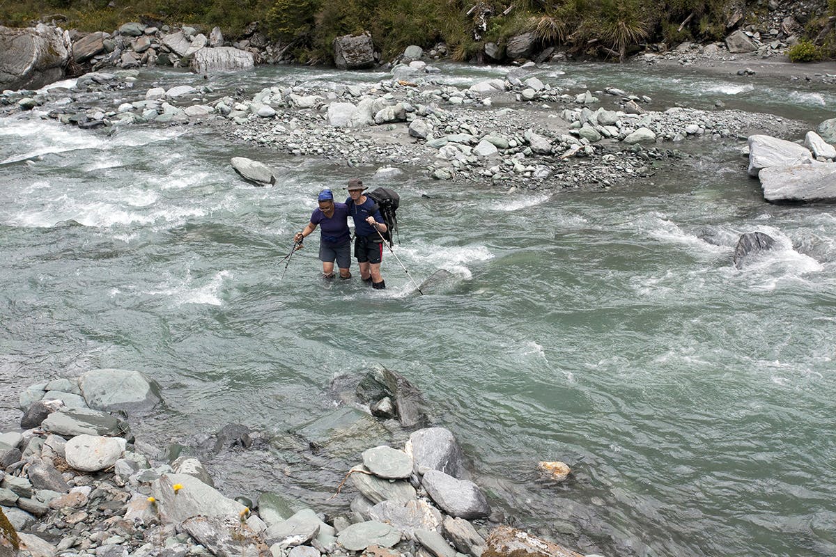
Malcolm and Millie link up to ford the Wilkin River South Branch. Photo: Ray Salisbury / Lighthouse Creative
Right on sundown, we arrive at Top Forks Hut. It’s actually two adjoining buildings; the 1968 deer-culler hut that houses two young track-cutters and the newer hut, built by the Park Board in 1978. We have truly earned our stripes today, so I volunteer to prepare dinner. Outside, a starry sky heralds clear weather as the last rays of sunlight creep up the summit cone of Mt Pollux. The alpenglow is truly a spectacle.
Viewing the notorious Waterfall Face was on our agenda, but our party is still in recovery mode from the previous day’s ordeal. A mild, sedate visit up-valley to some picturesque lakes is deemed more manageable by our adventurers from Auckland.
In the afternoon we ford the South Branch of the Wilkin, demonstrating the art of river-crossing to the newbies in our group. With some determination and a fair amount of profuse sweating, we clamber up a rooted track onto a high plateau. The Disappearing Tarn is spilling onto the path, so we splash along until bypassing the melancholic, moody waters of Lake Diana; another tanin tarn locked in a mountain cirque.
Across an alpine meadow, we follow the North Branch until the outlet at Lucidus Lake, an inland sea trapped by morraine; coloured slate grey like the clouds which scud overhead, obscuring the towering peaks of Castor, Apollo and Mercury. In 1891, Charlie ‘Explorer’ Douglas carried a copy of Homer so the legendary surveyor named these landmarks with Greek Olympic deities or their Romanised titles. In Roman mythology, Castor and Pollux were the twin sons of Zeus. In the Wilkin Valley, they are the highest 2500m-plus peaks. An avalanche careers off the slopes of Pollux, so we retreat to the perceived safety of the huts for the night.
The next morning we cross the Wilkin, its waters clear and inviting and no longer a fearsome force. Linking our arms together, we are like the Tight Five in a rolling maul – nothing can stop us now. We find it easier going on the true left, walking down an airstrip to Jumboland. My friends have found their tramping legs, so we carve three hours off our return journey to Kerin Forks and to our gear stash. It is great to see Ivan again, and reclaim our bunks at ‘KFC. Stage One is over. Deanne suggests a spontaneous swim in a side-stream, a welcome diversion in which all participate.
The following day, Malcolm assesses the Wilkin River, which is still running higher than usual. I remember an old kayaking motto: ‘If in doubt, scout’ so make a separate reconnaissance. We decide not to risk the crossing. Instead, we wave down Danyel in her jetboat and, for a meagre $15 each, hitch-hike to the far bank, and enjoy dry boots for one day.
Day walkers on the guided Siberia Experience trickle down the track to rendezvous with their jetboat pick-up. They’d been flown in by fixed-wing aircraft earlier in the day. This section of the Gillespie Pass circuit is therefore well-built and significantly easier to negotiate. A wide path utilises switch-backs to negotiate a bluff, then gently descends onto luxurious grassy flats beside Siberia Stream. After a couple of hours walk we spot Siberia Hut, a small dot on the swept ochre skirts of the mountains
We while away a lazy afternoon in our bunks, waiting for clear weather to cross Gillespie Pass. Two Aucklanders arrive via an adventurous route over Mt Turner and Tiel Creek. A trio of Israelis appear, then some Aussies. The hut wardens here are paid for the summer season and work two week rotations. In the winter, ‘our’ warden works for a local guiding company to manage base camp at Mt Everest.
We spend the next day at the hut, indulging in a cold-water wash, river-side. Malcolm and I, being achievement-oriented males, decide on a dash to Crucible Lake. This involves a calf-deep crossing of the Siberia and a half-hour ascent up a steeply rooted track which leads to a hanging valley. At the scrub-line, a profusion of red and yellow flowers grow in a natural rock garden. We wander along this beautiful alpine meadow to climb the morraine wall which dams the terminal lake.
Topping out, we gasp in amazement at the jaw-dropping, raw beauty of Crucible Lake, an aptly-named circle of teal-blue melt-water cluttered with icebergs; some glistening white, some dirtied with recent rock debri. Mt Alba appears through the mist, its brazen black ramparts sliced with a single silver thread of falling water draining the Axius Glacier. We drink in the monochrome world of grey cloud, black rock, and white ice. A hailstorm hits hard, so we scurry away like ants.
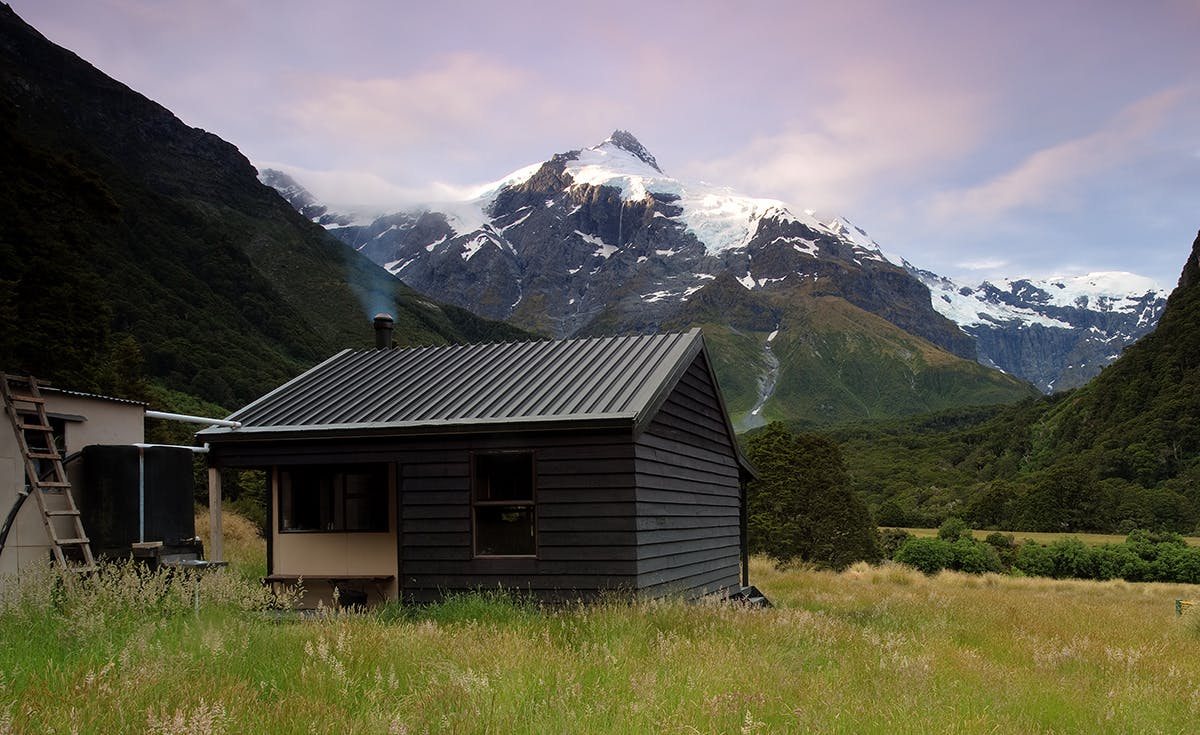
Top Forks Hut near the head of the Wilkin River: a perfect base for daywalks. Photo: Ray Salisbury / Lighthouse Creative
Back in Siberia Valley, we search for a suitable water-hole in which to bathe. Merely two minutes from our hut, Malcolm and I strip off under a triple-tiered waterfall for some hypothermic shock treatment – the water chills us to the bone, but we feel invigorated. Back in the hut, Bill has done himself proud as the party pyromaniac and his crackling fire has our wet gear drying.
My friends leave Siberia on our seventh day as low cloud hangs in the valley floor like an unwelcome guest. The mantle of mist is soon burnt off by a blazing summer sun. In no particular hurry, I indulge in tea-drinking and general lethargy, delaying my departure by some 45 minutes. Cruising along the old cattle flats, I think that Mt Dreadful doesn’t quite live up to its name. I catch up with Millie and slow to her pace. As a self-appointed Tail End Charlie, I act as sweeper at the back of the group, carrying the locator beacon and first aid kit.
The track gradually zigzags up a forested spur, then drops into an alpine basin. I can taste salt on my lips from sweating – this is a punishing 1000m climb. On a grassy clearing by the bubbling brook of Gillespie Stream we rest. I note that there’s excellent camping here as we refill our drink bottles. Three hours have passed when we climb out into open tussock terrain. Here we find Malcolm, so I push on ahead through the snowgrass, trying to catch those newbies from Auckland who are determined to complete this trip for their 25th wedding anniversary.
A flock of kea circle overhead, as I photograph the rich medley of subalpine plants. The final push for the pass necessitates kicking steps in the snow, then hopping along weathered schist slabs until reaching the flat ridge-top where my friends are lunching. At 2192m high, Mt Awful dominates the basin. The sound of birds chattering arouses my curiosity, so I mount a telephoto lens on my camera and began hunting. Sure enough, rock wren are busy hunting for insects amongst the nooks and crannies of this 1600m alpine pass. I am entertained as these rare, comical birds elude my advances.
We quickly dispense with the knee-wrenching descent into the Young Valley, where we find more water in the lush green headwaters. Boulder-hopping and route-finding is relatively easier along this section, following poles to a small bridge spanning the roiling reaches of Young River, still a benign stream. The track now plummets into the forest, losing altitude fast, until we arrive at Young Hut. We’ve had a Bluebird Day with knock-out scenery, but we’re knocked out too. Time to rest.
It’s our last day and the rain has really set in. So we set off, clad in polypro and waterproof shells, sweating in the humidity but glad we’re nearly out of the woods.
After a couple of hours of tough going, we arrive at the forks and head for the large cooking shelter nearby. Huddled together, drenched to the skin, we dine on dwindling rations as the voracious sandflies dine on our exposed flesh.
As the afternoon rolls out, patches of blue appear in the broken sky, allowing some sunshine through to lift our spirits. In places, the old track has fallen into the Young River. After a small eternity, we reach the radio shack at the river mouth. Malcolm and I scout for a suitable crossing of the Makarora and a fly-fisherman assists us in finding a shallow ford. Linked together, we carefully shuffle back to civilisation on the far bank. Relieved that we are all safely on terra firma, I stride out to SH6 and hitch-hike back to our car.
After eight days of tough travel, we are a week behind the rest of New Zealand – lost in time, and out of touch. When my friends do return to the city, nothing has changed, but they have. The wilderness has that effect on you. It reduces life down to stuff that actually matters: basic necessities such as friends, food and shelter.
