A return journey to a favourite hut has the makings of a grand trip
Twenty years is a fair stretch of time in anyone’s life, enough of a span of the years for much water to have passed beneath the planks and to have moved on to different places, even a different life. For me though, revisiting a secluded hut deep in the hills of central Canterbury, up on the Main Divide in Craigieburn Forest Park 20 years on brings great contentment – the contentment of the hills. God’s place I like to call it, where the passage of life is lost, for a moment, among the grandeur and serenity of the mountains where such a span of time is but a blink of an eye.
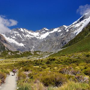
Unknown Stream Hut is a special place, way up where the Wilberforce Valley is constricted between the flanks of the ranges and Canterbury’s space is completely lost to view as the Unknown Stream curves in a wide arc southwards beneath the Cascade Range. This is magnificent isolation where the only track is the river bed, and even that at the whim of the river.
So it is that three of us, Nic Ashley, Mike Latty and I trek in late one mid-winter’s day, having left our car hours back at the homestead and taken to mountain bikes for the first lumpy section of 4WD road north of Castle Hill. The road is, fortunately, frozen – without the freeze it would be a mud-slick, something we are to discover on the return leg.
Bikes don’t normally feature in the tramps I do, but on this occasion we made a last minute decision to take them and speed our progress up valley during the shorter winter days. They prove their worth, despite the full packs we carry, and we reach Fanghill Stream in just over an hour. Though it’s possible to ride further we choose to ditch the bikes here as our round trip though the valleys and over a rugged little pass makes carrying them an unattractive option.
The eastern side of the Wilberforce has great walking access, all the way to Urquharts Hut, so we employ this alpine highway and make quick work of the mid-valley reaches passing below the mighty bastions of Mt Murchison, crossing the river at Logans Mistake to gain the west bank.
Our river crossing is dry-shod, quite a treat at this season, as the winter lock-up of melt water and rainfall usually results in any run-off disappearing into the river gravels for a large part of the river’s course. Farther up Nic and I make a side trip to historic Urquharts Hut while Mike heads round the big bend into the Unknown and our objective for this trip, Unknown Stream Hut.
Urquharts is a classic piece of high country history. Dating to 1930, it stands a safe distance from the riverbed on a lush terrace vegetated with a variety of sub-alpine species. As we unlatch the door and step into the spacious one-room interior it immediately feels like home. Eight bunks, a table, fireplace, and earthen floor it’s just the business for this neck of the woods. We sign the book, photograph the show, and head on into the Unknown.
Misty rain is pushing in from the north, occluding the tops. In the valley a chilly breeze is beginning to stir in what has been an otherwise windless day. Nic and I shoulder our packs once more, from where we dropped them on a river terrace, and set off over gravels to our rendezvous with my own personal history in this valley. It’s just a step or two up the stream until the valley sides fall back enough to allow terraces to survive the regular floods and there, snuggled onto and at the back of the first terrace, is Unknown Hut. Smoke curls from the chimney and there’s a welcome “Howdy boys” from Mike as we enter. “Brew’s on, so help yourself,” he says as I familiarise myself with this rustic little refuge, a legacy of the culler’s era and dating to 1970.
“Hey, it’s good to be back, Mike,” I start off. He was with me last time we passed this way, en route to Unknown Col and the Whitcombe, so our return is a shared memory of a good trip in the hills.
There’s little more to do now, other than soak up the hut experience, complete with roaring fire, hissing primus, hanging billy, warm sleeping bag, and a good old yarn about places been and people met.
Darkness fills the valley when I venture out after dinner, a few stars shine weakly and light rain is falling. Tomorrow is far away. For now, there’s a good kip to have in our snug haven.
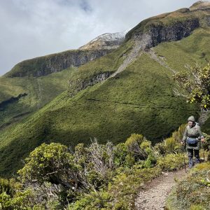
We schedule a pre-dawn start for our pass crossing day and outbound tramp down Moa Stream, a feeder of the lower Wilberforce. We are greeted by darkness, light snowfall and cool winds as we make our way over tussock and gravels to the foot of Moa Saddle. It’s an easy walk, but we are wary of the pass access due to the numerous hut book entries warning of bluffs, thick scrub, and steeper scree. We needn’t have worried however as we locate a poled route off the riverbed leading to a well marked, if slightly overgrown, track winding up through the forest and bluffs.
Mist drifts randomly, occasionally revealing mountain tops and snowy faces or a window along the corridor of the Unknown. A kea calls, a breeze stirs the tussock but otherwise all is still. The pass is just 200m above the valley floor and we gain it readily enough before pausing at the top in the stiff southerly flow emanating from Moa Stream. Below, to the north, Unknown Stream curves past in a graceful arc, her glacial heritage unmistakable from this angle – a flat gravely bed surrounded by steep sided mountains and truncated spurs.
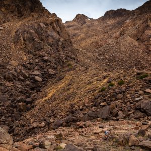
South of the pass we enter the Moa Basins, a world of sub-alpine shrublands festooned with snow where deep drifts make slow going until we gain the bed of North Stream and are able to make better progress, though care is required to avoid the ice sheets lying in the stream bed. The basins are remarkable landscape features nestled below the high peaks at the modest altitude of 1000m from where we gaze south, into the jumbled crests of the Rolleston Range. Gold miners once fossicked here, over 100 years ago but there were scant pickings.
North Stream is an easy descent with good boulder hopping in the lower valley as it nears the Moa Stream confluence. By the time we reach Moa Stream, the sky is rapidly clearing but it is still cold and our postponed lunch stop is beginning to tell. Moa Hut is not far off, so we head over the river flats and into the forest to locate the tidy little four-bunker for a cook-up and some respite from the cold.
The hut interior is dank but we make it homely for our short stay and enjoy a rest on the mattresses as the billy boils. Lunch is over far too soon, propelling us reluctantly into the winter world beyond the hut.
Though it is some weeks since the last fall, snow lies thickly on the forest and flats, protected from the weak winter sunlight by long shadows cast by the towering peaks.
Lower Moa Stream is a delight to tramp, with large open flats bordered by beech forest, a boisterous river and impressive views of the ranges as it nears the Wilberforce.
Dusk is stealing over the valley as we gain the Wilberforce and strike out across its bony wastes for Fanghill Stream where our bikes are stashed.
Though we are weary, we’re not beyond appreciating the marvellous space and beauty of the valley on a winter’s evening as breaks in the cloud allow intense patterns of sunlight to fall on the shoulders of the peaks.
Back at the bikes at last after 10 hours on the go, we mount up as the daylight fades. As we peddle off into the dark, uphill on the mud-slick trail, where a crescent moon casts its faint light on our labours, Mike calls out: “Hey mate, this isn’t just a good trip, it’s a grand trip.”
Wild File
Access From Rakaia Gorge (SH77) along the Coleridge, Homestead and Harper roads through to Harper River at the head of Lake Coleridge and then to Upper Glenthorne Station from whom permission is required to walk the 4WD road into the upper Wilberforce Valley (Ph 03 318 5801)
Time 2-3 days
Grade Moderate
Map BV19, BW19