
Tucked away in a knot of rugged country north of Haast Pass, the Macfarlane is not a river many will have heard of. It’s an isolated place, cut off from the Haast Highway by the Landsborough River and blocked in by Cuttance Ridge on one side and Shattered Peak on the other.
It’s one of those places no one ever mentions and was deliberately left out of Moirs Guide North. No one appeared to notice. But I was curious and last summer my curiosity got the better of me. So when a few capable friends from the Christchurch Tramping Club said they were interested in a five- or six-day trip over New Year, I told them I had just the place.
It was raining when I headed south to meet them at Hawea. The Rakaia River was within a metre of the road bridge. More fronts of similar severity were forecast, but I figured conditions weren’t likely to get worse. Heading to South Westland when conditions were so unsettled wasn’t the sort of advice Mountain Safety would give but it might improve, and we were inspired by the trip. Sometimes you have to suck it and see.
We hoped to approach the Macfarlane Valley by crossing the Mateketeke Range and the Thomas River then traversing part of the Thomas Range. Then we planned to climb out of the upper Macfarlane Valley and descend to Horseshoe Flat in the Moeraki to return to the car.
Sun sparkled on the bush and grass when we parked at the Moeraki end of the Haast Paringa Track. So far so good. It took about an hour and a half to wander in along the benched formation to Jack Farrells or Blowfly Hut, and it is one of the most pleasant bush walks I know. The forest is varied, with plants like the world’s largest moss, Dawsonia superba, beside the track and a rich variety of birds, tomtits, kakas, robins, fantails, brown creepers and even blue ducks in the river when we reached it. There are also yellowheads in the area.
Climbing above the track, we picked through the light scrub under silver beech, emerging onto the tussock tops of the Mateketeke Range. These are wonderful tops and worth a trip in their own right. Tarns studded the landscape and we enjoyed long stops and slow travel over knolls. But as so often happens, an easy afternoon stroll meant a rush later on as we tried to keep to schedule. Passing Lake Dime we climbed over Pt1319m and dropped down to another lake where, by 8pm, we camped. A long day, but a good start.

Morning saw us looking carefully at the Thomas Valley and beyond. Today’s mission was to cross and camp at the bushline opposite on the Thomas Range. We found a clean beech bushline to drop out of the tussock and open travel led down a spur towards the river. By lunchtime we were sitting on a grass flat by a fire boiling the billy. Nearby a stream entered the river from a pool the colour of sapphire and fed by a waterfall. The mountains have some gorgeous gems hidden away.
In the afternoon, with whio swimming in the river, we sidled up valley on the true left to Windrow Creek and the spur beyond. Windrow Spur proved good travel, leading us through red and silver beech to the bushline. Mist was down on the tops, and we looked for a cosy campsite with dead wood for a fire. Water came from a tarn, the only one nearby. Curious kea challenged us, and kaka called from the forest.
Based on the last long range forecast we’d seen, a small front was due and after dinner, sure enough, rain drifted in. By morning the world outside was sopping, mist hung down to the bushline and droplets weighed the tussock leaves down in arcs. Not good conditions to head into unknown tops travel. We waited a bit. By 10am the mist was still on the range, but the drizzle had eased. Time to suck it and see.
Climbing through an area of superb alpine flowers, celmisias mainly, we headed towards the range crest. Mist hung around all day, but the breeze was very light and drizzle held off, so travelling wasn’t unpleasant. Short clearances even gave us a look into the Roaring Billy, a valley I’d been in 30 years ago. It had been winter and I’ll never forget the excruciatingly cold crossing of the Landsborough to access it. Up here the tops were rocky and narrow in places, but still vegetated along the crest. Ourisias (mountain foxgloves) flowered in crevices and Racomitrium mosses on the rocks, tussock and bare ground raking across the saddles. Travel was good and we rolled along, enjoying the pleasure of being there. In the afternoon, we dropped into a saddle with a big tarn, reminiscent of tops near Lake Nerine. It would have been nice to stay there, but our plan meant we should be a bit further on. Besides, it was still misty and quite cold. A fire in the head of the Macfarlane sounded nice so we went for that.

Walls surrounded the head of the valley, but steep scree led us down into a jumble of boulders, some with heavy black veins of fine crystals. Down in tall tussock our eyes scanned for a salubrious campsite. The evening sky continued to clear as it darkened and dew chilled everything, but our fire roared in compensation. It was New Year’s Eve and nestling into my down bag I watched the stars in the wide night sky wheel from ridge to ridge. Nothing quite connects me with a place like a night outside, listening to sounds rising and falling, feeling the shifting air brush my face. I slept as deeply as the valley itself.
The morning bode well for the year – clear, bright and fresh. Leaving at 9.30am, we crossed tussock basins, followed the stream in places and then sidled on the true left from the bushline, emerging onto extensive flats at the junction with the Macfarlane. It was lunchtime so we lay and sizzled there in the sun. This was the life. But a warm, restless wind flicked around the flats. Time to move.
The upper valley is an expansive place, and travel is straightforward. Walking up the river stones allowed us to make good time past Blackfoot, Sioux and Ironstone Creeks to where the valley head splits into two. We moved a short way up the true left branch before climbing above the forks and over into tussock of the true right branch. Water bubbled and sparkled as we sidled up through tussock into a hanging basin. But the weather was catching us. Overcast skies squeezed out the last of the sun and cloud clambered onto the peaks. Pity, because the saddle between Ranganui and Rainytop is a cool place, with tarns and good camping. Just not in a storm.
We headed to our right, onto a spur off Ranganui despite being late in the afternoon. Once I probably would have tried to talk people into camping up here, but I’m getting boring and a night in a hut seemed preferable to another trashed tent. We got to the Moeraki River at. The trip down had turned into a bit of an epic. Things went well until we tried to force our way down a ferny bluff we weren’t prepared to go back up. You probably know how it goes. Anyway, ledges and greasy walls forced us into a rivulet of waterfalls, greasy sticks and bigger bluffs below. We took out our light rope and one of us climbed a log up a bluff to a place we could sidle out of the mess. All a bit dodgy, but it worked. Sort of. It was now dark, and somewhere in the mess my ice axe ripped off my pack. There were ferns and bluffs for Africa – it could be anywhere. The last hour or so by torchlight led us through light tunnels in a maze of supplejack and jungle, but finally we stumbled out into the Moeraki riverbed for a night crossing.

The river crossing was fine, but already the first drops were falling. Somewhere on the true right was a track. Somewhere on the track was a hut. Confidently we probed across flats expecting to see a marker or two. Nothing. We went further. We went up-valley a bit. Finally, grasping at a faint line in the grass since nothing else had brought success, we ambled along and a wonderful orange triangle loomed out of the dark. We finally arrived at Horseshoe Flat Hut at 11pm. My diary entry from that night says: ‘All completely knackered and ripped and torn and tired’. At least I was. Rain began in earnest overnight, heralded by massive thunderclaps. Getting down had been the right decision.
Rain pelted the tin roof while we were snuggled up dry and warm and purring with pleasure. But by 2pm it was time to move on or spend another night there. It is only a few hours to the road from Horseshoe Flat, and there is a DOC track all the way. How hard could that be?
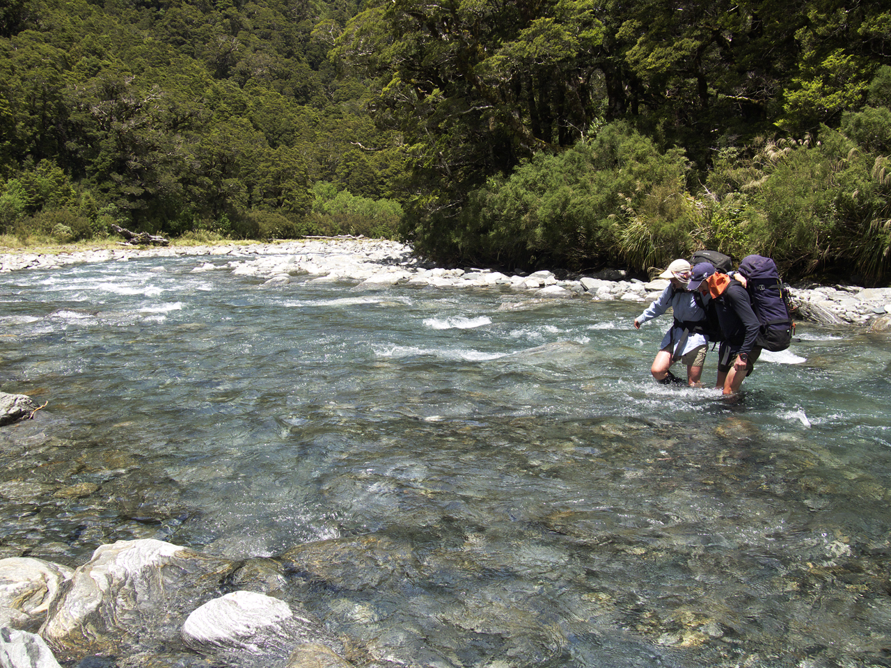
Linking up, we crossed a murky side channel of the river and back. So far so good. But the valley floor here is swamp country and water spread out under the forest in lakes. A minor creek became a linked-up chest-deep crossing. The next one became a swim, out of depth and uncertain how far through the scrub we would have to swim, with a gentle but insistent current pushing us off track into the brush. Water as far as we could see. Dripping wet we moved on, but worse was to come. A wide, deep and faster flowing channel brought us up short, and we stood there looking at it for a while. Sometimes the best choice is to back off, and that’s what we did, swimming and sloshing back to the hut. Huts can be havens, and Horseshoe Flat was for us right then. We lit a big fire and steamed and dried off.
Torrents fell overnight and in the morning the river was much higher. We waited. By late afternoon the river was down half a metre and we had another go. In places there were hundreds of metres to wade, but there was only one swim across a creek. The river frothed its way down beside the track and by 9pm we were on the old Haast Paringa Track again, reaching the car about 10pm. My old car leaks and about 100mm of swimming pool filled the floor wells.
But she still ran and we headed back to Hawea.


