
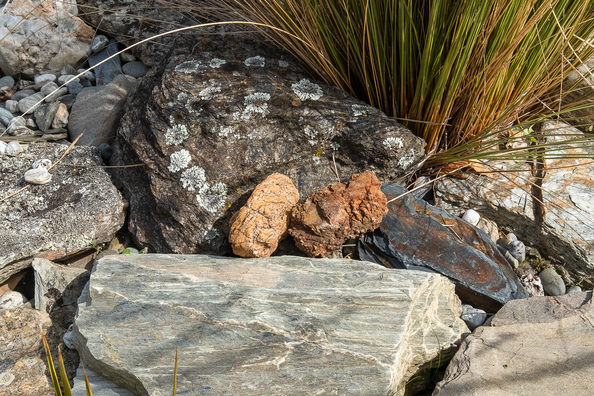
Ultramafic rocks were formed deep below ancient volcanoes over 250 million years ago and uplifted over millions of years by movement of the earth’s tectonic plates. They are mineral rich, high in concentrations of iron, magnesium, chromium and nickel. Their striking colour is effectively the iron within the rock rusting. The mineral soils produced are nutrient poor and toxic to most plants, resulting in vegetation that is small-leafed, stunted and sparse.
Nelson’s Red Hills is an intriguing landscape. On our first day we skirted the edge of the ultramafic zone, below the large expanse of The Plateau and Porter Ridge, where scrappy mānuka on the lower slopes transitioned to sparse tussock and exposed, coarse red rock higher up. Everything feels harsh in the ultramafic zone. An oppressive heat emanated from the dark rock, and we were relieved to find a small shady gap in the mānuka in which to pitch our tent at the end of the day.
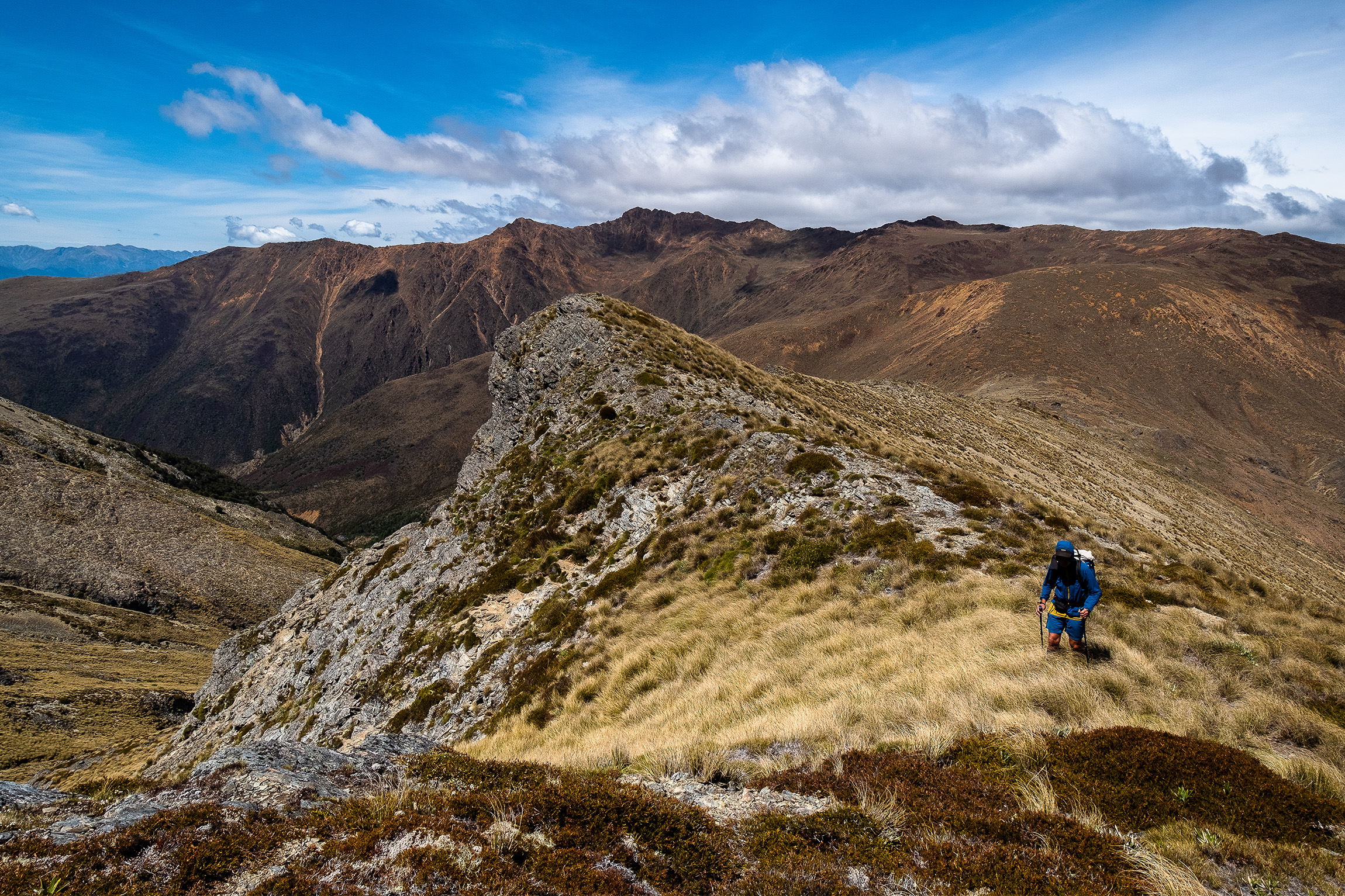
The next morning we left the track and the scrub behind and climbed an untracked spur through tussock onto fun boulder fields on Porter Ridge. It was cloudy and drizzly, but the ridge provided interesting travel regardless. On a grand scale, the landscape seemed uniform as the long ridge of reddish rock extended in front of us. But on a smaller scale there is surprising diversity. The rocks come in various shades of red, yellow and brown, and the terrain varies from large grippy rocks to areas of fine brown dust or orange and red screes.
Somehow plants survive here, especially adapted to the conditions, their roots travelling through crevices to the nutrient-poor soils. Many are endemic to the Nelson ultramafic zone, and David enjoyed botanising as we climbed to the high point of Porters Knob. As we continued along Porter Ridge the cloud cleared, revealing an impressive view across the headwaters of the right branch of Motueka River to Red Hills Ridge opposite. More red rocky outcrops and knobs. Scars of red scree as far as we could see. It’s stark and barren yet beautiful and unique.
After a sleepless night we left the ultramafic area and walked back onto soils with more familiar alpine vegetation. The transition between these two geological zones was remarkably abrupt. Once off the ultramafic, the plants were so much more luxuriant and the grass carpet underfoot blissfully soft. Our exit took us over Mt Ellis and Ben Nevis and down through tall beech forest to the Wairoa Valley.
Upon arriving home, we placed the red rock in our garden and eagerly pored over maps of our impending journey to South Westland. David’s final comment in his diary of Porter Ridge summed up how we both felt: ‘I loved this trip – so excited to visit Red Mountain now.’
Four weeks later we set off to South Westland in search of our second rock. Our trip was to be 10 days: we would travel up Cascade River, traverse the Red Hills Range, drop back down to the Cascade and return via the northern Olivine Range. Along the way we would be dipping in and out of ultramafic areas, with the high point a climb of Red Mountain (1705m).
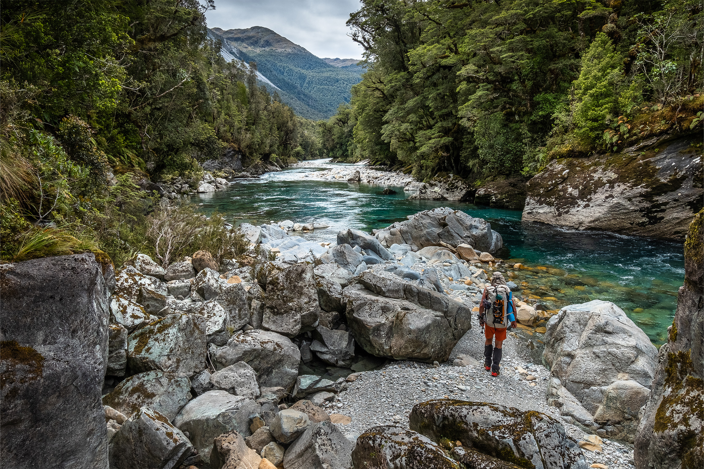
Unlike our Nelson adventure, this trip was considerably more remote. It took three and a half days to reach Red Mountain, which sits within the Olivine Wilderness Area. We started at Jackson River Road, almost as far south on the West Coast as the public road would take us, and walked up Cascade River for a day and a half following deer trails in silver beech forest, ambling along river flats and bush-bashing around a couple of bluffs. It was our first time in the almighty Cascade, and we were impressed. Large deep-green pools contrasted with turbulent rapids and delicate mossy banks, and huge dead trees in the middle of the river flats demonstrated the immense power of recent floods.
On our first day we stopped at Woodhen Creek on a flat grassy site fringed with flowering toetoe. The creek was dotted with ultramafic rocks, washed down from the higher eastern flanks where a band formed an island of mountains within what was predominantly a schist landscape.
of mountains within what was predominantly a schist landscape.
Another day travelling up the Cascade and a second valley campsite was followed by a waist-deep crossing of the river. We then bush-bashed up to the northern end of Red Hills Range to a pretty area of the bushline dotted with tarns and tussock clearings.
We had assumed this range would all be ultramafic, but clearly, our geological knowledge was lacking. The ultramafic zone doesn’t begin until Peridot Creek, much further along the range, where the alpine fault slices right through the middle of the landscape.
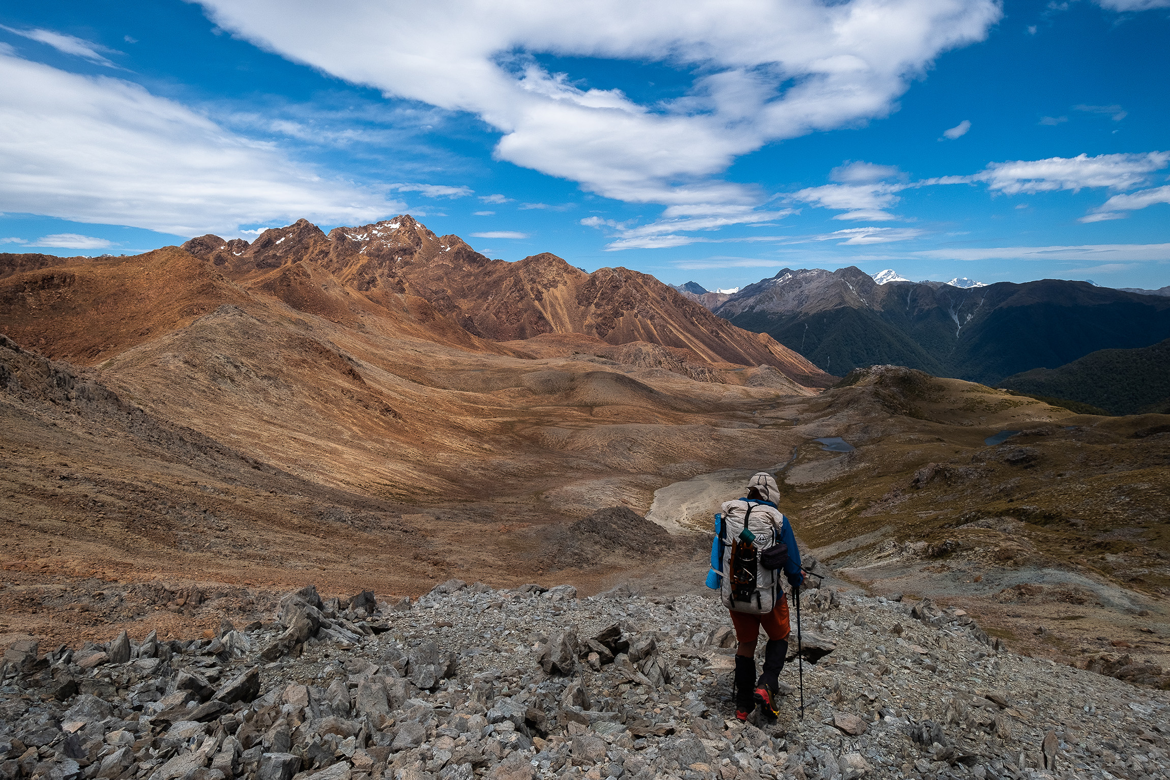
From a campsite among tussock, we left early with the hope that we would have time to climb Red Mountain later in the day. The views we encountered that day were special. Out west across rolling ridges of beech forest was the distinctive arc of Big Bay, where Pyke River meets the Tasman Sea. To the far south the skyline was dominated by the high snowcapped peaks of the Darran Mountains, and closer in, the rugged Olivines. Red Mountain loomed in front of us at the end of the range, getting larger and more impressive as we approached the transition to the ultramafic zone.
Again, the change was abrupt. One minute we were walking among short tussock with abundant flowering alpine plants, and within a couple of short steps we were on red rocky scree, looking down to tarns of electric-blue water. We dropped down to the upper slopes of Peridot Stream to find a campsite.
With the promise of daylight until 10pm, we left at 3pm to climb Red Mountain. The name Red Mountain only describes the general look of the area. Just as we had found in the Nelson region, there is an intriguing array of colour among the rocks: bright yellows, sometimes flecked with silver, shades of green, even pink and purple. Others have thin veins of jet-black intrusions.
It started raining as we scrambled up but we kept going, our wet fingertips taking a beating on the rough rock. A navigational error at a critical point 300m below the top almost thwarted our summit attempt: in the mist we had followed a lead up the wrong gully and were bluffed. With no time to retreat and try again, we sat down, heavy hearted. The rain had stopped by now so we decided to travel south to look for another way. Fittingly, it was a change in geology that saved us. Higher up, a thin band of dark rock had created a small ledge just wide enough for us to edge along, and we were soon on easy ground heading to the top. We were elated. We’d climbed the highest peak in the South Westland ultramafic area.
I tried to get my head around the fact that the rocks we were standing on had been formed 250 million years ago under the sea and were once part of the same body of ultramafics 500km away in the Nelson region. I knew I was simplifying it, but it was mind-blowing and just thinking about it made my head hurt.
It had been a long day. We made our way back down easier slopes to our campsite, arriving at 9.30pm as a fiery sun dropped below the horizon and turned everything brilliant orange.
The next day we followed an open stream of red rock back down to the lush Cascade valley, and for the following five days travelled north along the northern Olivine Range. We had one final day in the ultramafic zone, descending Martyr Spur: the rocks were harsh and abrasive, it was hot as a furnace and we were cooked mercilessly. Thankfully, subtle geological changes down the spur resulted in pockets of beech forest that provided much-needed shade from time to time.
We collected our second rock from Martyr Spur. We took our time, picking over many, looking for the right one. It is orangey red with tiny white veins running through it, and is lumpy and rough to touch.
We placed our South Westland rock in our garden beside its Nelson counterpart. It might be stretching things to say we re-united them, but the story of how they were formed together and then ended up at opposite ends of the South Island is scientifically correct. Sitting side by side, they are now our favourite rocks, and we will likely never forget where we collected them.


