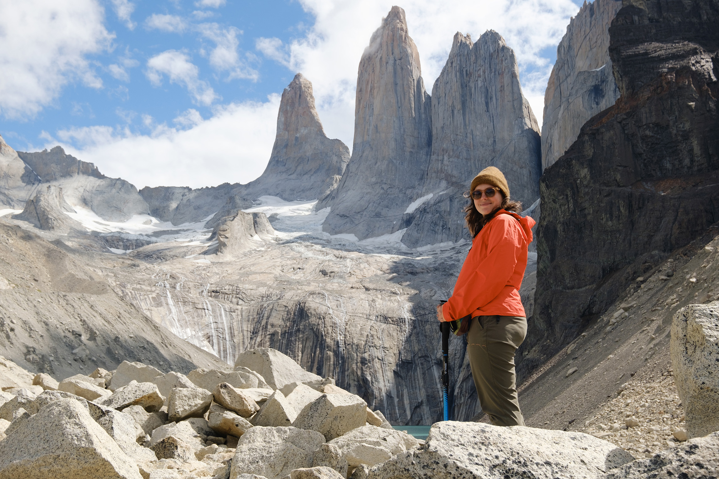
Visit Patagonia’s striking granite towers on this renowned – and logistically challenging – circuit. You might even see a puma.
Patagonia’s most famous multi-day hike, the W Trek, is diverse, challenging and wild. The five-day adventure is the postcard darling of Chile’s Torres del Paine National Park.
The 80km track is named for its shape, a messy W. It skirts two major glacial lakes, Lago Nordenskjöld and Lago Grey, and rounds three mountain ranges, the Torres, Cuernos and Paine Grande. It can be walked in either direction, or combined with a less popular, wilder northern track to make a loop, known altogether as the O Circuit.
The track’s most iconic feature is undoubtedly Las Torres, sheer granite fingers that reach from an electric-blue lake, cartoonish in their scale and profile. If walking the trail westward, Las Torres are reached on day one on an out and back trail of some 900m elevation. Expect traffic jams (think Aoraki’s Hooker Valley Track), as the route is a popular day walk.
Crowds will thin from here as the track rounds the emblematic Cuernos (Horns) on its way to 6km-wide Grey Glacier. A side trip up the middle valley system to Mirador Británico offers 360 degree views of the surrounding peaks.
The park’s wildlife is another drawcard, with guanaco, puma, condors, owls, flamingos and more making frequent appearances. During our visit, a puma stalked the campsite at dusk, a once in a lifetime experience.
Track accommodation is expensive. For two hikers carrying their own tents, prices can reach $170 per night. To stay in a provided tent, refugio (bunkroom) or hotel, expect to pay two to three times as much. Catering is available too, but at a premium.
Booking must be done well in advance, through (annoyingly) two different companies. Track transport includes a ferry and shuttles, and a national park entrance fee must be paid. If this feels overwhelming, there are many blogs and videos online that detail the best booking sequence. Booking companies will relieve you of this burden and organise the itinerary, but you will pay thousands. Guided trips, meanwhile, cost between $4000 and $9000.
Though the trek can be walked year round, summer is the peak season; like New Zealand, however, the weather is changeable and you can expect gales, sleet, white outs and snow at any time.
Often ranked among the world’s greatest hikes, the W Trek is well guarded by booking, weather and logistical obstacles, but it’s worth the hype.
– Matthew Cattin
Distance 80km
Ascent 2730m
Grade Moderate–difficult
Time 4–5 days
Forge your own path from Fort William to Cape Wrath through the wild Scottish highlands.
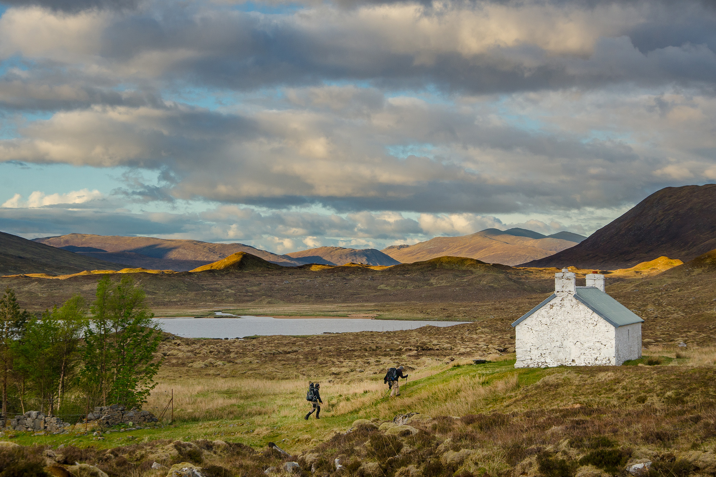
Anyone who thinks that Britain is too overcrowded to have any real wilderness or solitude should reserve judgement until they’ve attempted the Cape Wrath Trail.
By almost any measure, this is the toughest long-distance trail in the UK. But for those game to give it a go, it’s also perhaps the most rewarding.
The route takes you past and through some of the most dramatic and remote ranges in Britain. Although nothing like the height of the Southern Alps, they have the jagged shapes and imposing presence of giants. There are wilderness areas into which you could head off-piste for days and see no one.
In the far north stand some extraordinary castle-like summits, each one alone in a sea of heather; and shortly before the finish you reach the golden sands of Sandwood Bay. The beaches up here are like tropical havens but with arctic winds and water that hurts.
The brief for the Cape Wrath Trail is simple: start at Fort William – the town that sits at the foot of Ben Nevis, Britain’s highest summit – and find a way north. Then, just keep going north and don’t stop until the land finishes. This happens at the far north-western corner of the mainland at Cape Wrath: a rocky, unforgiving coastline with a lonely lighthouse perched on a cliff.
At no stage is there a formal trail. Instead, it’s a case of gazing at a topographic map of seemingly endless hills, lochs and glens, and trying to guess the line of least resistance.
It’ll be boggy, you’ll find the midges a match for Fiordland sandflies, and you’ll spend much of your time freedom camping (or wild camping as it’s known in the UK). On some nights you’ll get to stay in bothies, which are similar to New Zealand’s huts, though fewer in number and run by a charity called the Mountain Bothies Association, which makes them free to use. Very occasionally, you’ll get the chance to live it up in a bunkhouse or B&B (expect to pay around $70 a night for a bunkhouse bed).
Walking the Cape Wrath Trail in the British summer will give you the best chance of decent weather (by western Scotland standards). It will also allow you to take advantage of the incredibly long days enjoyed in this part of the world. The far north of Scotland can get 18–19 hours of daylight per day in summer – perfect for a trail so special that you’ll never want the sun to set.
– Matthew Pike
Distance About 365km
Ascent 11,000–12,000m
Grade Difficult
Time 2–3 weeks
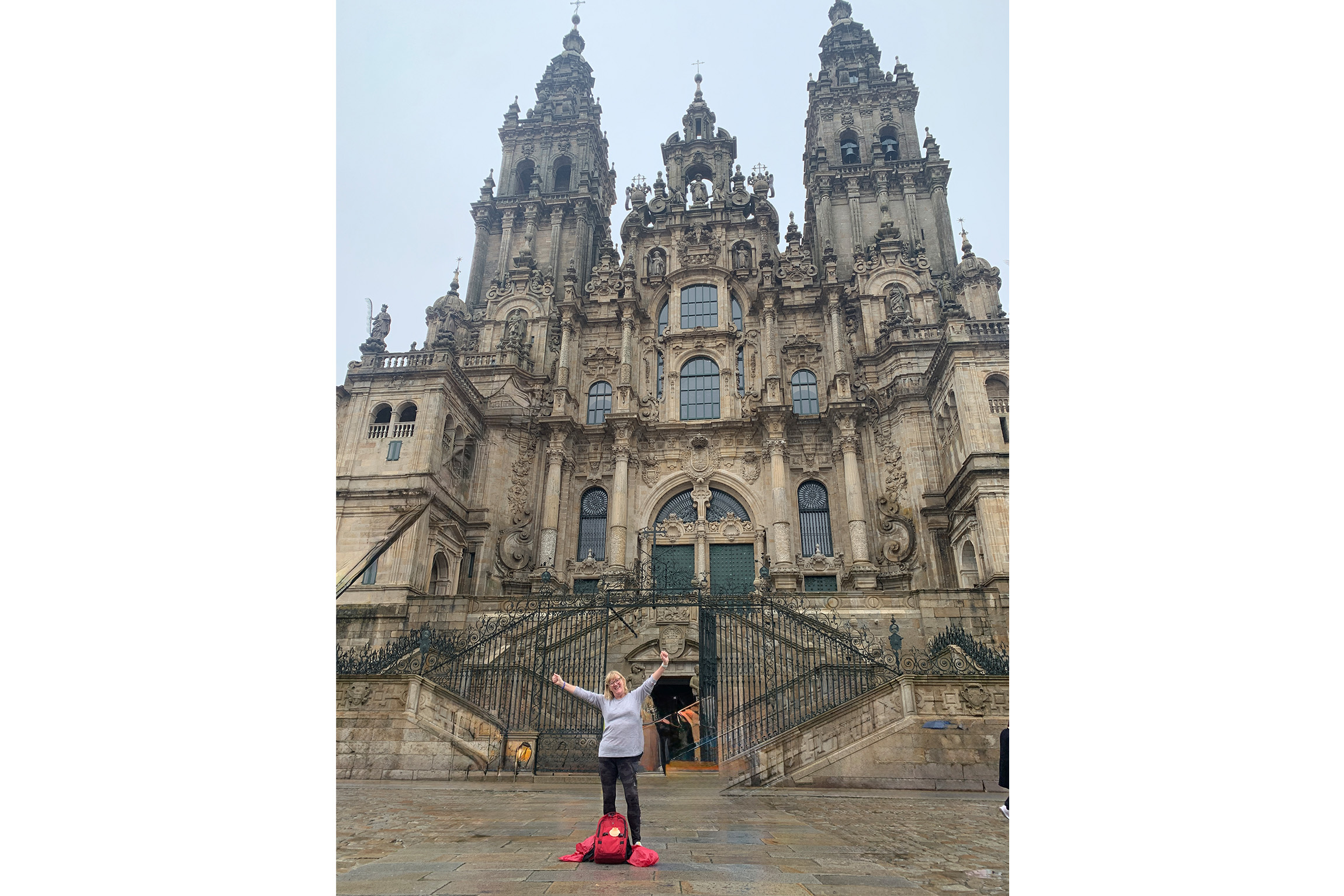
For over a millennium, people have been trekking to the Spanish town of Santiago de Compostela, the mythical burial place of Saint James, one of the 12 Apostles.
When choosing an international hike to embark on, most people seek spectacular mountains or forests. But what about visiting the mythical resting place of one of the 12 Apostles?
For more than a thousand years, people have been walking the Camino de Santiago pilgrimage route in northern Spain. The trek culminates at Santiago de Compostela, a city about 35km from the Atlantic coast, where a cathedral is said to be the resting place of St James’s earthly remains.
According to some traditions, the saint travelled to Spain to spread the word of Christ following the crucifixion and later returned to Judea, where he was beheaded by the king for his Christian beliefs.
His body is said to have been transported back to Spain and buried in Galicia, but the site of his tomb was apparently lost.
Almost 800 years later, a Spanish hermit named Pelagius had a vision that led him to St James’ long-lost tomb in the forest, and a church was established at the site. For the next millennia, European Christians made a pilgrimage to the tomb to atone for their sins, converging on a trail through the Pyrenees to Santiago de Compostela.
More than half a million people still make this pilgrimage each year, and although most walkers today aren’t trekking for religious penance, Camino tour operator Therese Brooking says many still come searching for answers to life’s big questions.
Brooking co-owns Walk This Way Travel, which focuses entirely on the Camino’s various iterations. She first did the trek herself in 2021 and has done sections every year since.
“Every time I go back I’m reminded that it’s not just about walking,” Brooking says. “It’s the people you meet, the conversations you have and the time it gives you to think. You come home feeling lighter, more grounded, and very grateful.”
Most walkers begin their trek from Saint-Jean-Pied-de-Port on the French side of the Pyrenees on a route dubbed the Camino Francés, or French Way.
It first climbs steeply over the mountains, reaching 1450m before descending the Spanish Pyrenees to the town of Burguete. The trail then continues to Pamplona and skirts across northern Spain through historic towns, climbs 1504m through the Montes de Leon and finishes at Santiago de Compostela Cathedral. The 780km trek takes most walkers around 40 days at a pace of around 25km each day.
There are several versions of the Camino, including via Portugal and from southern Spain, with longer routes starting throughout Europe.
Lorraine van Dooren walked the Camino Francés last year and says it appealed because it offered the chance to meet other people doing the same trek and was safe and well catered for. She opted to stay in private accommodation and had her bags transported each day.
Van Dooren found it more challenging than she expected: “I’d done a fair bit of training before I went, so I knew I could walk 35km in a day, but trekking day after day is tough on your feet.
“I quite liked that challenge, though. If it was going to be simple, I probably wouldn’t have done it.”
She enjoyed the variety the trail offered: “Sometimes you’re literally in the middle of nowhere staying in the tiniest towns, and other times you’re in a big city and can visit cathedrals or Roman ruins and do some sightseeing.”
There’s a range of accommodation, but walkers traditionally stay in albergues, non-bookable dorms often run by churches or local councils, which can have 50 bunks or more. However, as the pilgrimage has become more popular, there can be a daily rush to reach a village before the albergues are filled. It’s one reason van Dooren and Brooking recommend booking at least some accommodation before you start.
The trail is busiest in the last 100km from Sarria – the minimum distance to qualify for the official Compostela pilgrim certificate. Van Dooren recommends avoiding this section if you have only a limited amount of time. “Up until Sarria, people were spread out and often I was walking by myself.”
She enjoyed the experience so much she’s heading back this year to walk the Chemin du Puy route, which begins in Le Puy-en-Velay near Lyon and continues 730km through southern France before joining the Camino Francés in Saint-Jean-Pied-de-Port.
– George Driver
Distance 780km
Ascent 13,331m
Grade Moderate–difficult
Time 40 days
Follow in the footsteps of shoguns on a former great highway that links Tokyo to Kyoto.
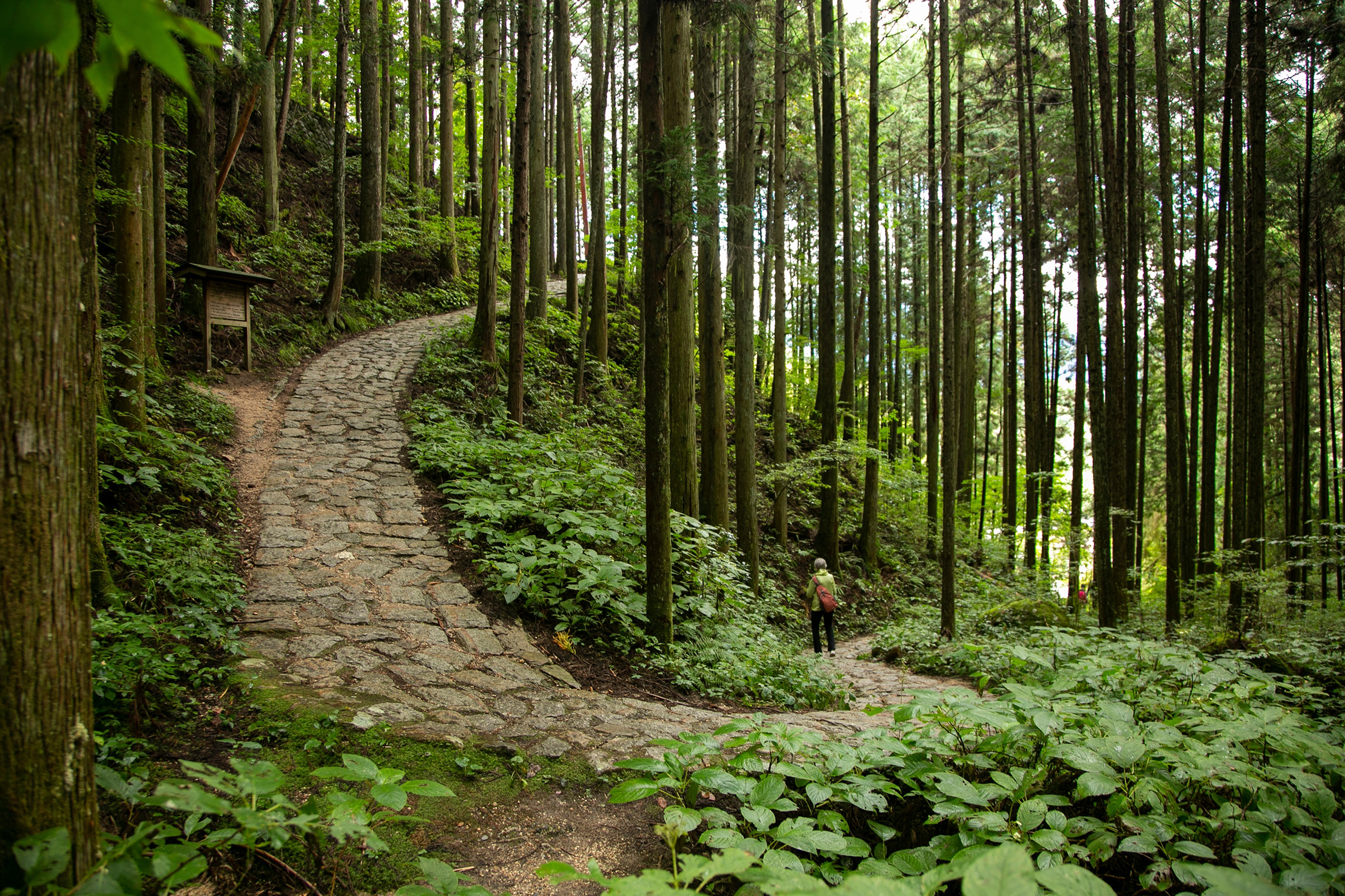
The Nakasendo Trail winds through the mountains of central Japan and was one of five great highways established during the Edo period (1603–1868) to connect the capital, Edo (present-day Tokyo), with Kyoto. The trail carried merchants, samurai and travellers through a string of 69 postal towns, providing a valuable communication network for the Tokugawa Shogunate.
Today, stretches of the trail are along major roads, so hikers usually cherry-pick the most scenic parts and leapfrog between them using public transport. Perhaps the best aspect of the trail is the chance to stay at traditional inns or ryokans and sample delicious local cuisine.
The preserved 8km section between restored postal towns Magome and Tsumago is the most popular. Visitors walk along original cobbled paths, past wooden inns and waterwheels that offer glimpses of a bygone era. Further north the tourists empty out as the path crosses over low mountain passes and through cedar forests. The Kiso Valley is another highlight, dotted with shrines, bridges and teahouses. Bells are installed at intervals to ward off black bears, although sightings are uncommon. Give them a good ring or carry your own.
The trail can be walked in either direction, independently, self-guided or guided. Note that accommodation can be limited in places and some operators are slow to respond to emails, so choosing a self-guided or guided option offers a degree of certainty.
Autumn (September to November) and spring (March to May) are the best times for walking, with autumn generally quieter as spring showcases cherry blossoms. Summer gets very humid, while in winter parts of the trail will be covered in snow.
Distance 543km
Ascent 10,610m
Grade Moderate
Time From day walks, multi-days or longer
A desert classic, the Larapinta traverses an ancient landscape both rugged and remote. Depending on your comfort level, there’s more than one way to approach it.
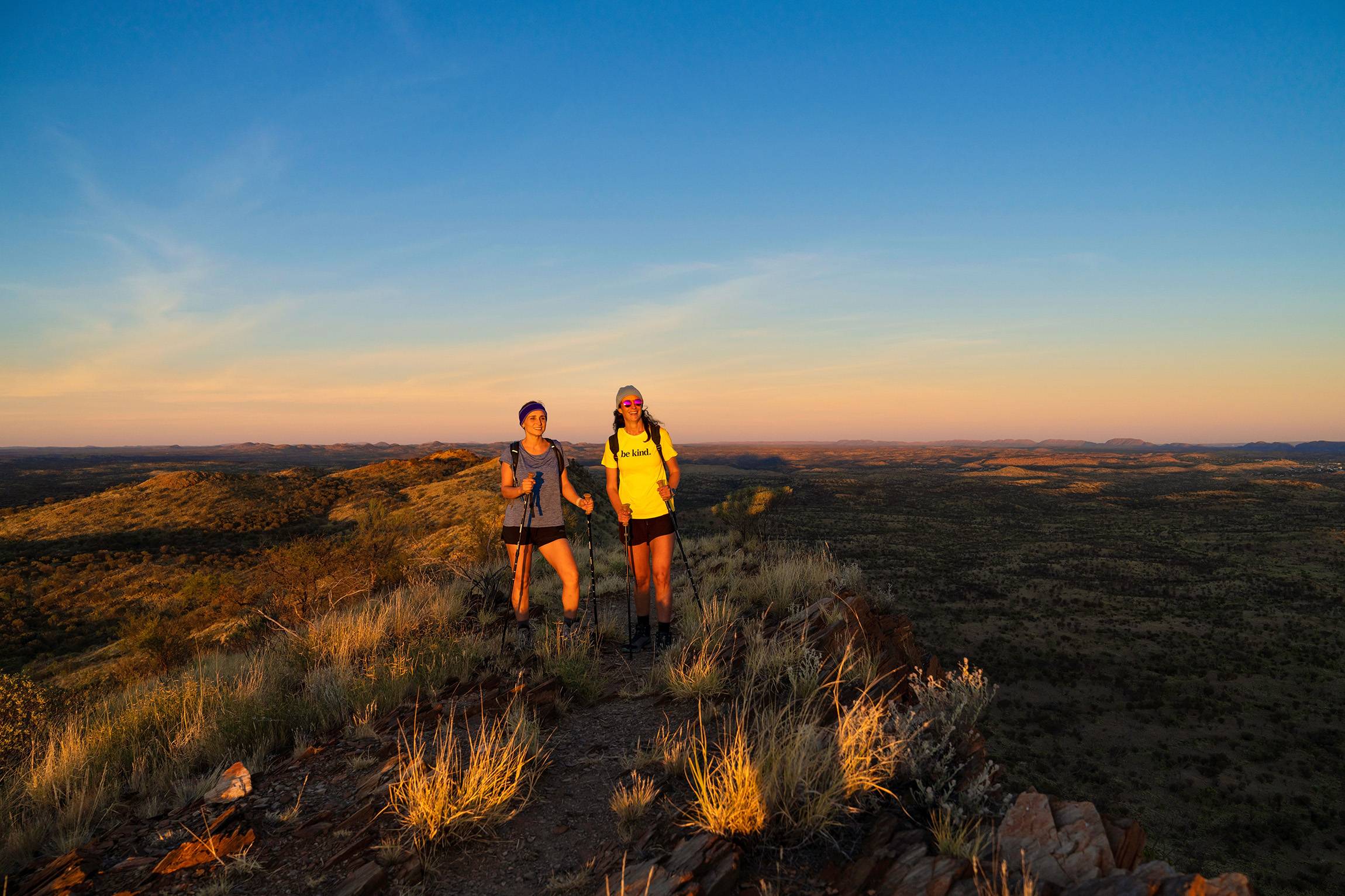
Red rock, mulga, land frogs, waterholes and desert sunsets. A 40,000-year-old Indigenous history. The Larapinta Trail in Australia’s Northern Territory is about as different from tramping in New Zealand as you can get.
That contrast, and prior trips to the outback, are what appealed to Lily Duval. “I’ve always liked the Australian desert, it’s such a beautiful place,” says Duval. “I wanted to do a walk that was really different from what we have in Aotearoa.”
The desert trail stretches 221km from near Alice Springs to Mt Sonder along the spine of the Tjoritja West MacDonnell Ranges. The rocky, remote route is divided into 12 sections with a camping shelter at the end of each. It is rich in wildlife and cultural values.
Larapinta translates as ‘salt river’ and is the local Indigenous Arrernte name for the Finke River that crosses the trail. The area abounds with sacred sites and dreaming tracks or songlines.
“I encourage anyone who goes to read up on the cultural history of the area,” says Duval. “For example, some places you can’t swim because they’re sacred.”
Duval and her partner Jolyon White also read up about the geography of the region, which was sculpted by an ancient sea millions of years ago. “Some of the most special parts of the trail are the chasms in the landscape,” says Duval. “Endemic fish species live in these unlikely waterholes, while on the rock faces, up quite high, you can see wave marks.”
The couple are experienced hikers and chose to take 14 days rather than 12 to complete the well-marked trail, which can be walked in either direction. Campsites must be booked in advance.
They organised three food drops and recommend taking plenty of snacks – and not underestimating the heat or the extra weight of carrying water.
“We walked from mid-September to October, and some days it was 35 degrees,” says Duval. “One day we carried 15l of water between us to get through a particularly long section. We often walked at night.”
Carla Pettitt walked the Larapinta six years ago and now guides for Life’s An Adventure, a boutique travel company that offers five- and six-day Larapinta tours.
“It can be a daunting experience doing a hike like Larapinta because there are a lot of logistics involved. If you’re doing it by yourself it can take six to 12 months to prepare, but a guided company is a stress-free approach,” she says.
Hikers enjoy the most scenic aspects of the trail from a permanent base without worrying about route finding, setting up tents or carrying a pack.
“We get people who say, ‘I could hike that, but I don’t know if I could camp that’,” says Pettitt. “It can get down to -4℃ at night.”
The best time to walk the Larapinta is from April to September.
Distance 221km
Ascent 7225m
Grade Difficult
Time 12 days
Take in Italy’s famous Tre Cime di Lavaredo on a route less travelled.
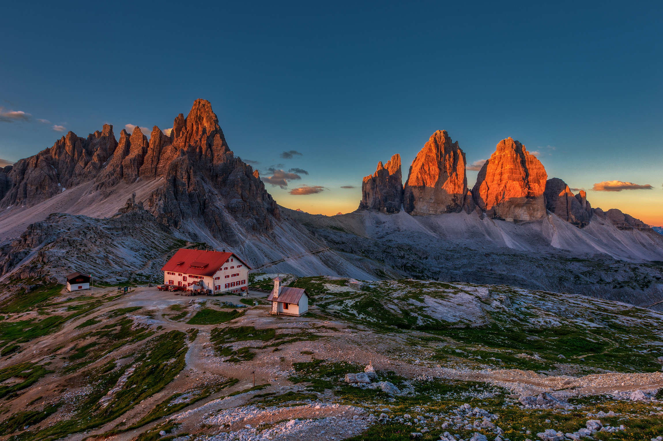
The Croda Fiscalina Circuit offers a quiet and scenic approach to the famous Tre Cime di Lavaredo. This trio of obelisk-like rock slabs are the symbol of the Dolomites and world heritage-listed since 2009.
Generally walked clockwise, the circuit weaves between peaks that rise so sharply they look photoshopped. A starting point above 1500m, and higher-than-familiar tree and snowlines, form an enchanting ramble through alpine terrain spangled with wildflowers. The topography, flora and fauna – including gawky marmots and alpine salamanders – are literally a world away from Aotearoa.
But perhaps the biggest eye-opener is the ‘huts’. The first, Rifugio Fondovalle, 30 minutes from the roadend, is basically a hotel. Its three-course meals and Austrian wheat beer are served al fresco with an alpine panorama that can only be described as bellissimo! You can share your pics instantly via the hut’s wifi.
The circuit winds past four such huts, and even those further from civilisation offer similar luxuries. Zsigmondy Comici – three hours in, at a height nearing that of Taranaki Maunga – comes with a full restaurant, bar, electricity, bedding and hot showers. With 80 guests, dinner was a rowdy affair and the dorm room a tad claustrophobic.
The huts are linked by networks of Great Walk-standard tracks and can generally be booked with dinner and breakfast included. Their spacing means it’s often possible to dine at another hut for lunch (even a sneaky beer).
This European approach to ‘roughing it’ creates a different style of multi-day hiking. Alpine playgrounds can be traversed ultra-light, carrying minimal food and no cooking equipment, utensils or sleeping bag. You can opt for a leisurely itinerary or cover serious ground with relatively little pack-hauling pain.
It’s not a perfect bed of wildflowers though. This kind of hiking can challenge a Kiwi’s perception of ‘getting away from it all’. Other hikers are almost always in sight, and snapping a photo often means waiting for others to vacate the world-famous backdrop.
June to September is the best season.
– Pete Barnao
Distance 19.2km
Ascent 1180m
Grade Moderate
Time 8–10hr