
“Six hours travel and six hours tramping. That’s day one,” I conclude to my companions, as, in the failing light of dusk, we stride the last easy section of the upper Makarora Valley in Mt Aspiring National Park, bent on reaching dog-box-sized Makarora Hut.
It’s been a long day, beginning with a pre-dawn start from Christchurch to make the most of the shortening mid-autumn days and also to set us up, time-wise, for the ensuing five-day hike on which we have embarked, taking us from the serene beauty of the Makarora over the Young Range to remote and mysterious Hunter Valley. Then, on into its very headwaters before crossing the Main Divide at Wilson Pass to enter rugged South Westland via the Wills River and eventually the Haast Highway.
Despite the heavy load I carry, including tent, mountain radio, camera gear and provisions for five-plus days, I am delighting in the challenge and the attraction of new country ahead, particularly the Hunter which I have long wished to enter.
My buddies on this march are long serving tramping mate, Mike Latty, good friend of his Bryce Jenkins, and our French connection, Father Antoine Thomas, a Catholic monk from the Community of St John, now based in Christchurch.
Though Fr Antoine is new to tramping in this country, having been here only a few months, he is no stranger to adventure having been in the French alpine troop corps, an extreme speed skier, a hang glider pilot, not to mention a mountain climber and runner. I have little doubt regarding his ability; it’s only his readiness to cope with the testing nature of the New Zealand mountains that is unknown. We’re a good team, however, and the weather report is benign with a large intense high lodged over the southern half of the South Island while gales, rain, and floods rage on in the North Island.
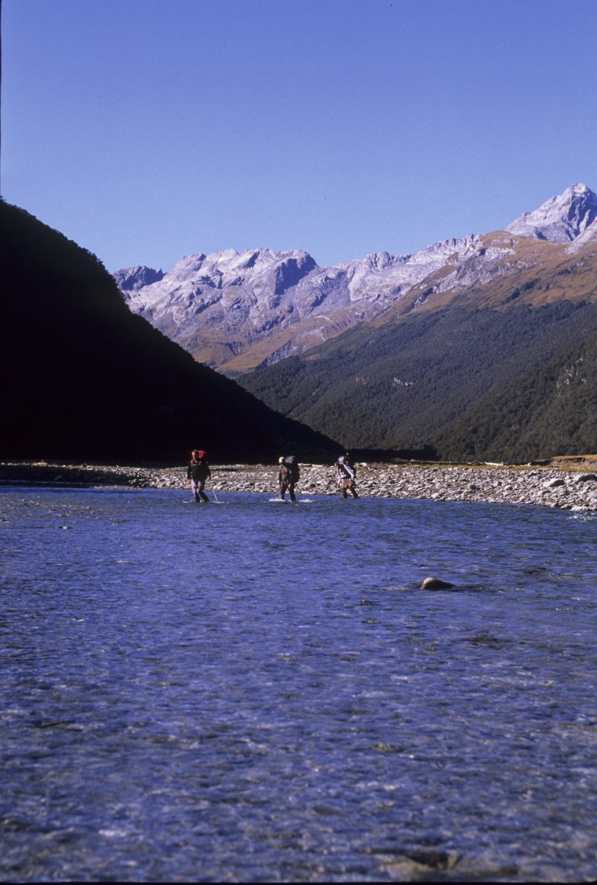
The Makarora Gorge Track which we have just ascended has been a trial. Mega-floods over the preceding summer trashed large sections where it once crossed easy terraces and made travel slow and tedious. We began the tramp at the Haast Highway, dropping off the flood-scoured terrace at Davies Flat, immediately plunging into the knee-high swirling embrace of the Makarora River.
This caused Fr Antoine a moment’s surprise, but he recovered well with a cheery, “I see we begin the adventure early”. He’s not wrong, and so it will continue.
By nightfall we have a roaring fire going in the hut, dinner on and are starting to thaw out and feel weary from the day’s labours. What simple pleasure it is to eat and slide into a cosy sleeping bag as a brisk wind whips around the hut outside.
A pre-dawn start sees a coal black sky display a starry skein beyond the circlet of ranges on the valley rim – it’s going to be a magnificent day for our crossing of the Young Range to the Hunter.
Though there is no marked route there is a regularly used pass – Scrubby Flat Saddle – on the ridge above the hut that crosses the range at a modest 1550m to reach Scrubby Flat Creek and thence into the Hunter. We locate the start of this route upstream of the hut, where the Makarora narrows as several bush spurs enter from the east.
Picking the most likely one we climb through open beech forest to gain a tussock basin and then move more steeply to the pass. As we ascend, the Makarora Valley expands below until with one glance we can sweep the entire upper valley from the icy summit of Mt Brewster, west to the unseen Haast Highway at the foot of the gorge.

Shrunken glaciers hug the southern gullies of the Main Divide while below these icy relics the valley falls away in great bluff faces and long bush clad ridges to the river flats. At the pass a chilling southerly wind is funnelling through the slot that leads to Scrubby Flat Creek so we decide on a valley site for lunch, heading down slippery snow tussock, eroded gullies, and pockets of scrub to reach the upper creek bed. The descent has not been without incident, all of us are sporting numerous grazes from our tussle with the scrub and I have a lacerated hand from a complete cartwheel over the thick vegetation. It’s good to stop.
We lunch at a small gravely river flat and revel in the hot sunshine and rugged splendour of the upper valley where unnamed 2000m summits lord it above fractured rock gullies and buttresses.
Downstream from here the valley offers easy walking through tussock clearings beside the river until the 1000m contour where the riverbed drops rapidly to the Hunter Valley 600m below.
Though we can see the Hunter, there’s a lot of rough travel ahead before we can reach it as the early section of the route is regularly cut by steep watercourses funnelling off the ridges and laying waste to the once-marked track. But when we reach the bush edge our pace quickens on a recently re-cut track and we hurry down to the Hunter and a riverside camp, at dusk, at the first flats we encounter.
It’s a cold night so we light a fire and huddle nearby, enthused with the progress that has gained us the Hunter as night fills the yet unseen expanse of the valley.
Dawn brings frost on tents and packs and a slow start in the chill of the new day, yet we are urged on by places ahead and huts to visit amid the majesty of the large valley system before us.
The Hunter River rises on the Main Divide, where it saddles with the Landsborough and Wills valleys in South Westland, flowing south for almost 50km to empty into Lake Hawea. It’s a massive catchment with an impressive rainfall, particularly near the Divide, and so commands respect with regard to travel through the valley, for although the terrain is easy, there are no footbridges.
Forbes Hut in the upper valley is our goal for the day, in what Mike terms a ‘rest-day’, meaning easy valley travel over a moderate distance with no scrub, gorges or passes to tackle. I’ll settle for that.
So it proves to be, another fine clear day is before us, the river is low enough to cross almost anywhere at will, we have time on our side and the scenery is superb. Mighty summits raise their icy flanks above the valley floor, the highest; Huxley, Abseil, Hammorack, Enderby and Barth are two vertical kilometres above us. We’ve entered a hidden world where few tread and those who do enter come on nature’s terms. Waypoints tick off as we progress northwards: Fergusson Hut and creek, Mid-Flat Hut; now just a chimney, Joes Flat, where we take lunch, and finally Forbes Flat and its remarkable hut setting.
Mid-afternoon seems a good time to stop, considering our late finishes and early starts over the previous three days, and Forbes Hut is truly welcoming.
Set well back from the river on a grassy flat so large it supports an airstrip complete with windsock and backed by an attractive streamlet flowing off the hillside, the hut is bathed in warm afternoon sunlight angling down the massive south-eastern faces of Mt Enderby (2338m) directly opposite on the Main Divide.
Far above, glacial shelves glint while in the valley only the sound of the river carries up to the hut; the wilderness never looked so good and best of all we have time to enjoy it.
The next two days of our traverse look to be tough going as we plan to cross the Divide and enter the even more remote and rugged Wills Valley in South Westland. That evening in Forbes Hut we discuss options, after having picked up another perfect forecast for the next three days on the mountain radio, we agree on a pre-dawn start to get us up to The Forks and the start of a short track in the West Hunter, and our route over Wilson Pass to the Wills.

Pre-dawn starts are tough going, everything is doubly unfamiliar and my body takes time to loosen up following the rigours of the previous days, but as we climb onto the low terrace at The Forks, having suffered a cold ford of the Hunter, daylight is filling the valley and we are pleased to be on the way.
The track leads us steadily up the narrow gut of the West Hunter, passing through windfalls and crossing the river once more until we break out of the bush into the upper valley. The head is a true alpine cirque, guarded by the glaciated summits of the Main Divide and the fearsome vertical abutments of sub-ridges fanning out to the south. The route to Wilson Pass looks intimidating; waterfalls plunge over vertical tussock and rock gullies and dense bands of scrub block the way ahead.
Pressing on we fight the good fight at the scrub bands, climbing over and through the thickest of it, finally being spat out onto easy tussock to begin the assault proper; up an icy waterfall gully to a large bench.
The day is flawless and we lunch at the top in a bid to lengthen our time on the Divide amid the majesty of South Westland beside a series of frozen tarns where ice-smoothed monoliths protrude from the tussock slopes. Mt Brewster’s mighty pyramid is clearly visible from here, its distance reminds us of just how far we have yet to go to reach the highway, so it’s packs up for the steep, rocky descent into the Wills.
The Wills is a challenge to descend. The head has been stripped by successive years of storm and avalanche and presents a quarry-like appearance. At first easy slopes provide the course but later the river drops away through massive boulders where over-steepened slopes and frozen scree give little purchase for our boots. Thankfully the river is low enough to cross and with a little scrambling we manage to dodge the worst obstacles, re-crossing to access easy terraces as the valley broadens below the cascades.
Sandwiched between the Divide and Bealey Range to the west, the open flats in the head of the Wills are a remarkable feature of this valley. Numerous steep watercourses form deep shadowy creases in the valley walls before disgorging their silty loads on the riverbed, while above rippling shoulders of golden tussock extend far up the peaks which in turn cap the ridge crests with mighty rock turrets.
Remnant glacial ice pockets lie among the mountains too, their pale faces adding depth to the landscape and recalling the time of glacial supremacy over the land.
As we push lower and scan likely terraces for a campsite, evening light fills the valley. Wedge-shaped peaks reflect the setting sun as the light shrinks from the valley floor and dusk descends in chill shadows.
At Sweet Nell Creek we pitch the tents on a carpet of tussock and begin to scour the slopes for firewood. It threatens to be a bone-chilling night.
Our nightly radio call brings bad news. My Dad, who is 93, is in hospital and things are grim, hasty plans may need to be made to get to Wellington on my return.
It’s a sobering reminder of the fragility of life and despite the fire and a satisfying dinner, we find it hard to get warm. Even in the tent sleep eludes me for some hours, the cold, and worrying about my Dad makes for a restless night.

Our final dawn in the hills arrives with a cracking frost and a renewed urgency to make the road today. Fr Antoine’s boots are frozen and he is having difficulty fitting them. “Give them here Father,” I offer. He watches, dumbstruck, as I promptly jump on them and hand them back. My brutal treatment works and they slide on. “Ah, good!” he sighs. “It’s not often you get to jump on a priest’s shoes,” I quip with a smirk.
Down valley we have some easy bush-bashing to make our way along an overgrown game trail to avoid a small gorge. It takes us high above the river before we descend to traverse a rocky canyon with the spectacular light of early morning slanting in among the huge boulders, spray and pools. With the last of the gorge travel behind us, we forge down the valley mid-section to Wills Hut, set on spacious river flats, for lunch and a quick radio call to check on my father. There’s no news to report and with a little time on our side we enjoy a longer than usual break.
Downstream the route crosses more flats with views to the valley head until the narrow gorge that drains the valley is gained. Here a sidle track begins and continues to the Haast Highway. The track is easy to follow, but testing, as it makes a tortuous path in and out of side streams, over slips, small rock faces, a vertical steel ladder, blown-out creek beds, and finally a large boulder-slip face at the Gates of Haast Bridge.
I’m ready for the track’s end by now, having gone on ahead to hitch a ride and fetch the car. Barely do I step onto the bitumen and a ride is offered. On my return, Mike, Bryce, and Fr Antoine are climbing up from under the bridge where the Haast River surges past, late sunlight is flooding the valley and there are huge grins on their faces.
“Now, I am a real New Zealand tramper!” Fr Antoine enthuses. He’s right, but the apprenticeship has only just begun.


