
Gaining experience in any endeavour often follows a learning curve.
Initially, as you gain experience, you’re cautious – you start on easy tracks and don’t progress to harder ones until you’ve developed the right skills. Afterwards, your confidence blooms as you gain boot-miles, perhaps by overcoming a few navigation challenges on off-track routes. Then there’s a relaxation of that initial caution, a feeling of being ‘at home’ in the hills. You do harder trips, feeling each time a bit stronger and more self-assured. So far, so good, but here the curve can get a bit bent.
Experience can relax your vigilance and – if you’re not careful – may lead to complacency. The curve dips.
Why do I contemplate this? Because I’m lost. On a track. In the Kaimanawa Range. I’m an experienced tramper, so how can I be lost on a track?
The day had started well. Friends Chris Maclean, Geoff Norman and I had flown by Cessna into the Boyd airstrip in the centre of Kaimanawa Forest Park. I was researching a new edition of my book Classic Tramping and wanted to check out a new track which DOC had marked between Boyd Lodge and Cascade Hut over Maungaorangi. This track stays entirely within the forest park, unlike the North Arm route, which traverses through private land and requires a permit.
Our initial plan had been to camp on Maungaorangi, which on the map looked like it would afford extensive views. DOC had informed us that there were tarns on the tops, but when we flew in, Air Charter Taupo staff told us there was no water up there whatsoever. A dilemma.
So I’d suggested to Chris and Geoff that they tramp up the North Arm route (we have permits) and meet me at Cascade Hut the following day. I would take plenty of water and camp on the Maungaorangi Track to ascertain its suitability as an alternative route. “All very well,” Chris said. “But what if you don’t turn up at Cascade Hut? Then we’ll have to come searching for you.”

Tempting as it was to be dismissive of this thought (what could go wrong on a track?) I recognised the wisdom in his comments. So I had agreed to scratch arrows in the dirt, showing my progress and direction of movement.
In what remained of the afternoon, I had raced over the track into the headwaters of the Oamaru and then started up the Maungaorangi Track. Despite being well marked, the track receives insufficient use for any real ground trail to develop. I pushed through spindly undergrowth up the steepish spur, until gaining the more undulating terrain of the ridge proper. Then I stormed along as fast as I could, hoping to reach somewhere decent to camp. Diligently I had scratched my arrows in any suitable patch of dirt.
With about two hours of light left, I passed a nice camp spot, but decided to carry on. After the sun had disappeared behind clouds, the light had grown dim. Savage winds had collapsed the canopy in places and dead tree limbs littered the forest floor. I pushed hard, sweating profusely, increasingly clambering over fresh windfall. Finally, just on dusk, I saw a fresh arrow in the dirt, but pointing in the opposite direction. ‘How odd,’ I had thought, ‘someone else has been along here recently, but headed south, not north. And they’ve scratched arrows too. What a coincidence!’
A few minutes later I had found a good camp spot, one that somehow looked slightly familiar.
So here I am on the track but completely baffled.
With a sinking feeling, I pull out my compass to confirm what my pessimism already tells me. ‘You idiot,’ I say to myself, ‘that was your arrow of course, and you’ve been going back over your tracks for God knows how long.’
Hot, tired and frustrated, I set up camp. After a meal and brew, I feel better and can dredge some humour out of my folly. Twenty-five years of tramping and still so much to learn.
I set off the following morning for Cascade Hut with the compass around my neck, and taking an easier pace to stay more attentive. After an hour, I find the point of yesterday’s U-turn – in a jumble of windfall. Somehow, I must have circled right around the mess of fallen trees and picked up a marker on the wrong side of it. Two hours of wasted effort on this tedious ridge. And it would probably have been more if Chris hadn’t told me to scratch arrows.
Maungaorangi does indeed have fine views, but no tarns. Dehydrated and hot, I descend towards Cascade Hut. The track seems interminable, with trickling streams audible but unreachable. I begin to feel light-headed and uncoordinated. Stately beech forest lines the track, but I can see no beauty in it. All I want is water.
Finally, the track crosses a stream and I stop for a long rest and copious brews. Chris and Geoff arrive, having had a pleasant trip through the North Arm.

At the refuge of Cascade Hut, we dump packs and I head off downstream to look at one of my favourite backcountry huts: Stanfield’s Whare. Built in 1958 using hand-cut beech pole framing and a malthoid roof, the hut’s best feature is a pumice chimney – reputedly one that leaks smoke out of every pore when the fire is lit. It has survived for more than half a century on a pleasant grassy terrace on the banks of the Tauranga-Taupo River, but I am horrified to see a recent flood had eaten most of the terrace away. Half the chimney is gone, the rest of the hut teetering on the brink. From inside, sunlight pours in the great gash in the chimney. (A few months later, I hear the hut had gone completely. A unique piece of backcountry history wiped away by the inexorable river – nothing lasts forever.)
Just three minute’s walk up the Tauranga-Taupo River from Cascade Hut lies the most exquisite gorge I’ve seen in New Zealand. Here, the river files through a slot gorge to emerge where water has sculptured the ignimbrite banks into a masterpiece of a landscape.
In the morning, North Island robins sing forcefully, the males trilling out their respective territories. So far, we’ve seen or heard riflemen, kereru, morepork, silvereyes, kakariki, falcon, kaka, kingfishers, tui, pipit, welcome swallows and both species of cuckoo.
Once across the Tauranga-Taupo, we are again on private land, headed for the heights of Ngapuketurua on a long bush ridge. When the track was well maintained, this section to Waipakihi Hut could be completed in one long, tough day, but now it takes two. We crawl under logs in places and skirt windfall in others. Anywhere a tree has fallen, storms play havoc with the exposed canopy. I clear away branches where possible, but the route needs the attention of a track-cutting crew.
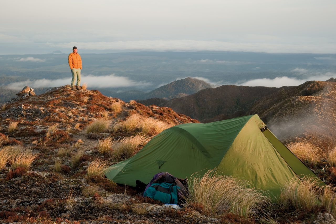
With relief we emerge on to the first section of tops, and climb to a shoulder of Ngapuketurua to camp. Lake Taupo sprawls to the north, one of the best views I’d had of it. Volcanoes line the horizon to the north and west: Ruapehu, Ngauruhoe, Pureora, Titiraupenga, Tauhara; while eastwards the Kaweka Range still sports late winter snow in exposed gullies.
A muscular westerly files over the summit, but we gain some shelter behind the brow of the ridge. Tents are pitched, blowflies buzz about and we eat a fine meal. Geoff has lugged a two-litre wine bladder and its contents aid the contentment of doing very little.
The sun sets behind the Pinnacle Ridge of Mt Ruapehu and a crescent moon hangs above. In the morning, cloud fills the nearby valleys and obscures the Tongariro mountains, but promisingly clear skies lie above. Easy travel on a good ground trail sidles around the several rocky knolls north of Ngapuketurua, but in another bush section we battle some of the worst windfall of the trip.
We lose 30 minutes trying to find the track. What could be a pleasant bush amble is instead a hot, scratchy, energy-sapping search for markers. Back on track, finally, we push on to Ignimbrite Saddle – glad to be in open terrain again. An outcrop of ignimbrite has weathered away to leave a curious collection of angular boulders, some of which have shed flakes that bleach bone-white in the sun. Orange circles of lichen cover others.
I scramble down to a creek to get water, and we loiter over lunch. A long ascent up to Junction Knob ensues, with the cloud evaporating and the mountains unveiled once again. As the day passes, Ruapehu draws perceptibly closer.
After pausing to take photos, I find myself well behind Geoff and Chris, who disappear over a false summit. I avoid climbing by taking a sidle route, where I intercept Geoff on the track down to Waipakihi Hut. We wait for Chris, but he’s nowhere to be seen.
We wait some more. No Chris.

Finally, Geoff pulls out his cell-phone. Full reception. He rings Chris. “Hello, Chris Maclean speaking,” booms the receiver. “Where the hell are you?” asks Geoff. “I’m enjoying the view like any sensible person would do on top of a mountain if they weren’t interrupted by their phone ringing!” responds Chris. Chuckling, I wonder what the trampers of yesteryear think of this electronic exchange in the hills.
Three hunters are in residence at Waipakihi Hut, having flown in from Poronui Station. They’re slightly incredulous at where we have walked from. The tramp has not been without its trial, and I’m pretty impressed with how well Chris and Geoff have handled long days. I hope I’m going just as well when in my mid-50s. They haven’t complained or made any malicious comments about my choice of route, but did mutter somewhat darkly about vetting future tramp proposals from me.
After a brisk swim in the Waipakihi, a whisky mellows our evening.
Towards dusk the hunters don camouflage gear and strap on rifles. “Off to war men!” one of them quips. It’s a short war and the deer win.
The Umukarikari Range seems easy country after the last few days, and a cool breeze helps soften the heat of the sun. Ruapehu reveals itself boldly, coming seemingly closer with every step, a stark white summit above the gravel corrugations of the almost barren Umukarikari Range. The old wooden marker poles have recently been replaced with blue standards capped with orange markers: highly visible for bad weather if not a bit unsubtle on a good day.
At the track end, we’ve completed a traverse across the Kaimanawas. Long-tailed cuckoos screech in the forest, heralding spring.


