
Spring: Round-the-Mountain south
The Round-the-Mountain Track scribes a large circuit around Ruapehu and crosses a pleasing variety of terrain from beech forest, open scoria fields to the barren expanse of the Rangipō Desert. I’d tramped it once before but this time wanted to make a diversion to visit Whangaehu Hut.
The map showed that a logical route would be to tramp the southern half of the circuit, then, from Whangaehu Hut, traverse over Ruapehu’s Summit Plateau to Turoa Ski Field.
One spring three friends and I set off from Ohakune Mountain Road, tramped past Waitonga Falls and, in cloud, reached Mangaehuehu Hut, the southernmost of those on Ruapehu’s Round-the-Mountain circuit.
In spring Ruapehu usually glistens with snow, but so far clouds had obscured the mountain. So it was with great pleasure the following morning that we watched Girdlestone Peak/Peretini emerge out of the teasing clouds as a sharp, icy spire. That day we emerged from the last stands of mountain beech into more open country, crossing some of the large valleys so characteristic of this south-eastern side of the volcano, and into the high desolate country of the Rangipō Desert. While not a true desert (it receives far too much rainfall), Rangipō lies in the mountain’s rain shadow. The high, dry environment leaves any vegetation stunted and ground-hugging and lends the area a starkly beautiful quality. I particularly like the prostrate dracophyllum, which matches the reddish scoria with its own russet hues.
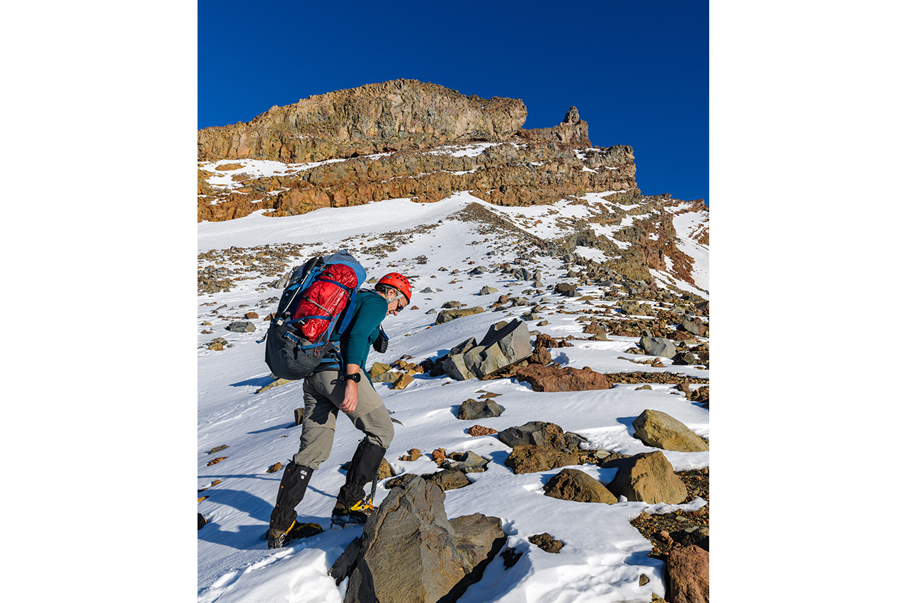
Rangipō Hut is the highest on the Round-the-Mountain Track, but even so, we faced a decent climb to reach Whangaehu Hut on our third day. After crossing a colourful gorge in the Whangaehu River on a swingbridge (which has been replaced a few times after being destroyed by lahars), we headed off-track and up a ridge directly towards the small club Tukino Ski Field.
A poled route leads through bluffs and past ski lifts onto higher terrain, and we donned crampons from the ski field. The route climbs a final ridge where views of the Whangaehu Glacier finally unfold, before a short but steep and slippery descent to the hut.
That evening under the light of a moon and star-spangled sky, the steep slopes of Ringatoto Peak glistened and our candles cast a soft, warm glow in the hut’s windows. It was then that I fell under the spell of Whangaehu Hut and first appreciated its singular position.
We intended to drop down the steep slope into the narrow gully to access the broader Whangaehu Glacier, but conditions decide this route, and it was far too icy for us. Instead we climbed around the base of the Clocktower Ridge and across to Mangatoetoenui Glacier. The sastrugi cliffs of Te Heuheu and Tukino Peak frowned from above as we worked our way between small bluffs, cramponing higher until we breached the Summit Plateau.
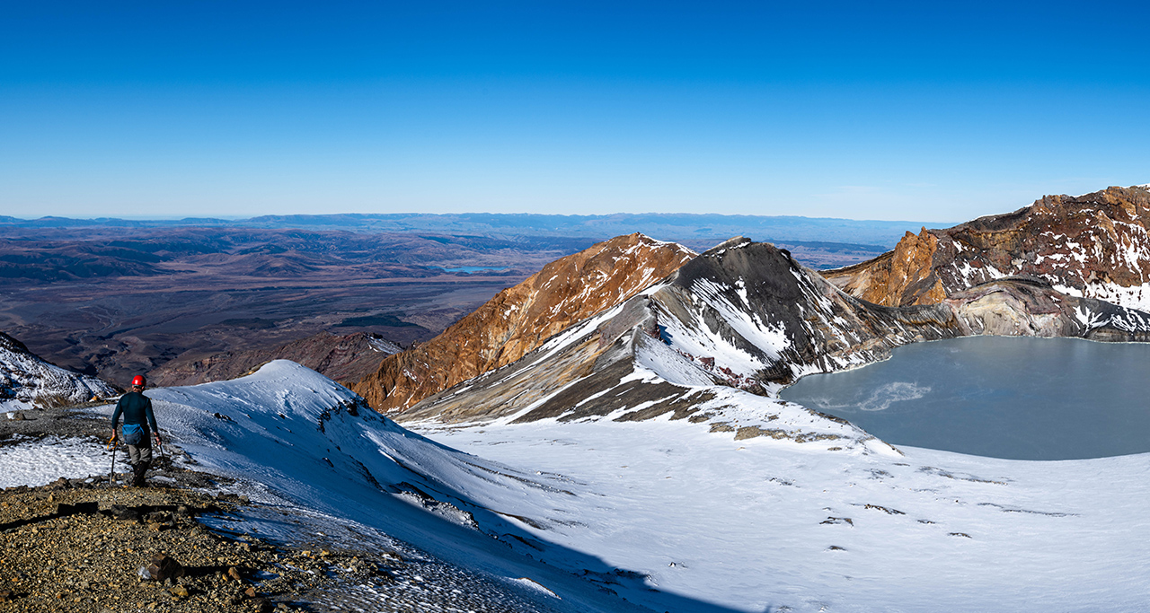
This flat snowy basin, almost one kilometre long, offers fast travel, and soon we were enjoying the classic view of Crater Lake/Te Wai ā-moe. The lake was a steamy turquoise but can range in colour to a smoky grey, depending on acidity.
From the saddle at the head of Mangaturuturu Glacier we made a long, angling sidle across high alpine slopes to reach Turoa Ski Field.
Not without irony, we realised that crossing downhill runs of speeding skiers would be the most dangerous part of our trip. Only once we had all played this Russian roulette could we fully savour the conclusion of an excellent alpine adventure.
Autumn: Round-the-Mountain north
For some years afterwards I harboured the idea of completing a northern version of the previous trip. The idea was to begin from Tukino Ski Field, spend a night at Whangaehu Hut, climb to the Summit Plateau, camp, descend the Waihohonu Ridge to a second camp, and finally intercept the Round-the-Mountain Track to follow it back to the Tukino road.
The end of lockdown in 2020 seemed as good an opportunity as any, and Peter Laurenson warmed to my idea. Autumn would provide different conditions for this adventure and I was looking forward to seeing the volcanic mountain rocks exposed in their full colours.
Whangaehu Hut had been empty for weeks. When we looked at the gulch below, it looked nastier than ever without its winter snow covering so we abandoned any idea of reaching Whangaehu Glacier. Instead, we took a route around Clocktower Ridge, scrambling on rocky ledges and edges. Cathedral Rocks, devoid of ice, were this time blocky bluffs, more like ruined castles than a church.
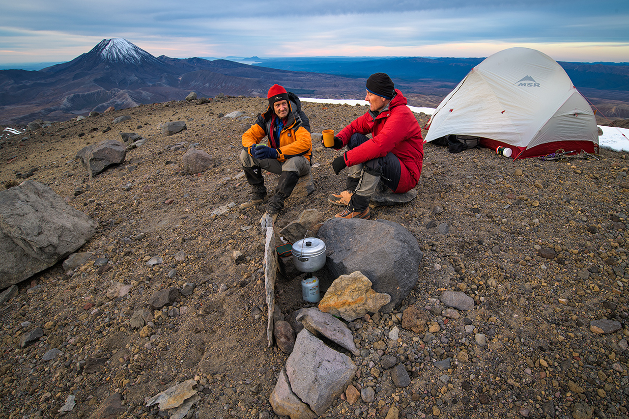
In autumn the Summit Plateau was a mixture of icy furrows and exposed rock rather than a flat, snowy expanse. Not as pristinely beautiful as winter perhaps, but more textured. We pitched our tent on the Dome and enjoyed a 360-degree panorama of the central North Island.
The following day we traversed the plateau and scrambled along the ridge towards Tukino Peak and Te Heuheu, thankful for the perfect, calm conditions. After backtracking slightly from the summit of Te Heuheu (2732m), we sidled to the top of Waihohonu Ridge. I’d always wanted to investigate this route, once the most commonly used to ascend Ruapehu. This was back in the early 20th century when access was via Whanganui riverboat, stagecoach and the original (now historic) Waihohonu Hut.
On the map, the ridge looked straightforward but in reality there were little bluffs and loose gullies to negotiate before the angle eased off. On flat ground above the 1900m contour we found a snowbank for a water supply and decided to pitch the tent, despite it being only mid-afternoon. The blunt form of Ngāuruhoe rose on the northern horizon, and the many ridges of Ruapehu ran down the slopes before us, knitting together like clasped hands.
That’s the joy of Tongariro National Park: it’s so easy to wander off-track.
On our final day we followed a leading ridge down to the top of a gorge lined with old lava-flow bluffs. It reminded me of Iceland until a kārearea screeched above us, shattering any illusion of foreign lands. The bluffs blocked us as we tried to thread our way into easier going in the valley below. Forecasted cloud was coming in, fast, and we wanted to be sure of the landmark of the stream below. Eventually, the bluffs relented and we descended a gap to reach the stream. Before long we had intercepted the Round-the-Mountain Track just an hour from our vehicle.
Winter: Pyramid Peak
A little over a year later I was back at Whangaehu Hut, this time in the heart of winter, with my long-time tramping companion Darryn Pegram.
On earlier trips I’d liked the look of an easy line onto Pyramid Peak, which snaked up from Whangaehu Glacier. The snow lay thick, the cramponing was perfect, and at last I was getting the opportunity to access the Whangaehu Glacier other than by that nasty gulch.
From the glacier’s mid-reaches we crunched our way up the snow ridge in windless conditions and soon reached the easy summit of Pyramid Peak (2645m). We lunched under dripping icicles, from which we filled our water bottles, before cutting across the head of the Whangaehu Glacier to investigate the iced-up massif of the Cathedral Rocks. After crossing the Summit Plateau we toyed with the idea of climbing Te Heuheu, but laziness won.
On our descent of Mangatoetoenui Glacier we watched a group of climbers tackling ice cliffs, then made our way back to Whangaehu Hut where we’d left our overnight gear.
Even after three trips I am only just beginning to fully appreciate how many opportunities Whangaehu Hut offers for trampers with a modicum of mountaineering skills. More trips beckon. There’s Ringatoto Peak and Wahianoa Glacier, perhaps combined with a round trip to Rangipō.
The North Island’s highest hut offers such diversity of terrain that no two trips are ever the same.


