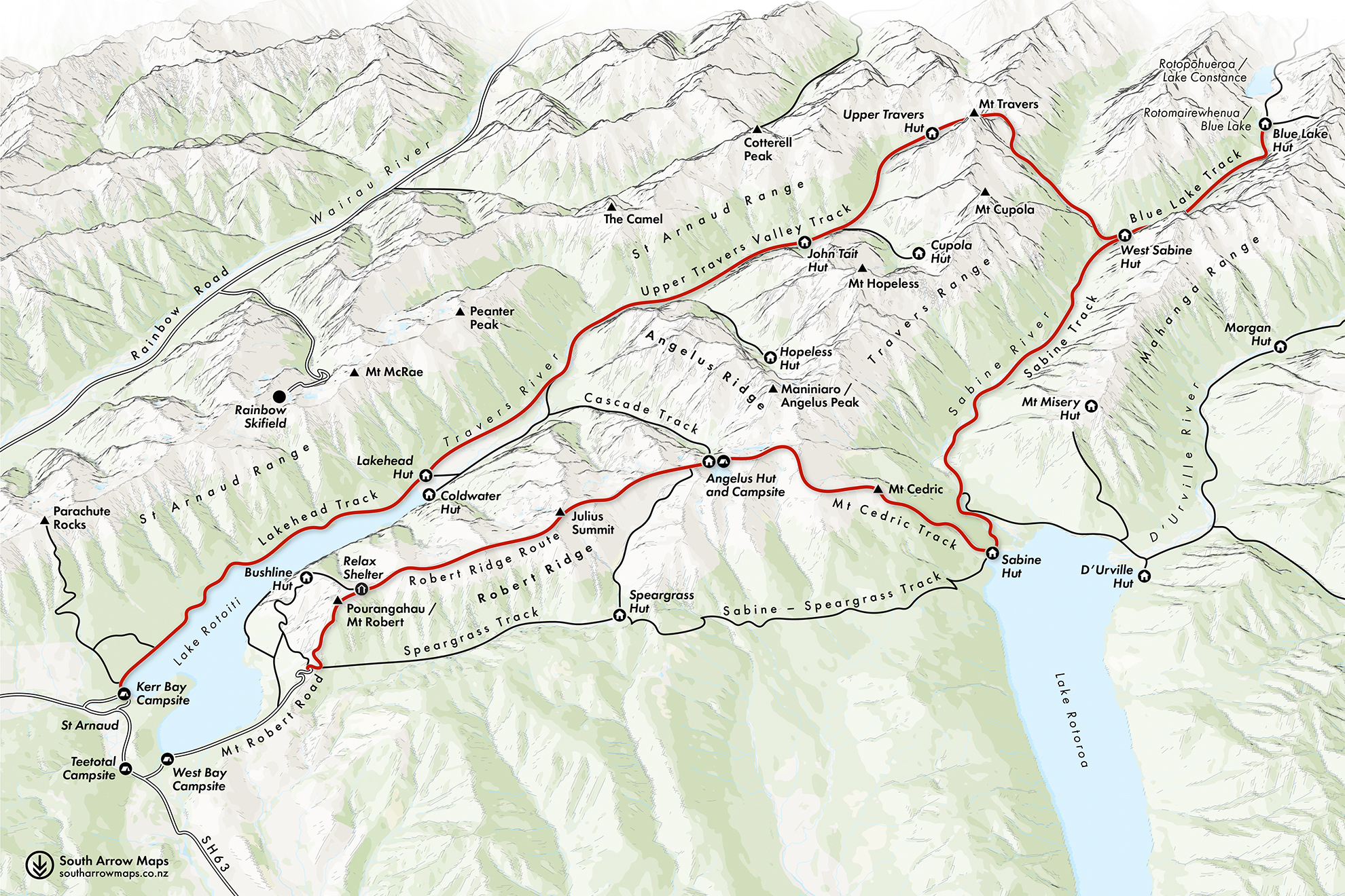
The weather is set to deteriorate, so we tackle Poukirikiri/Travers Saddle early. Already the highest reaches are veiled beneath a tablecloth of grey. We make short work of the climb, however, and as the track levels out, a whiteout descends to obscure Mt Travers. It’s hoods up and heads down as we begin the kilometre descent to West Sabine Hut. It’s more open to the west and we have dramatic views over Mahanga Range before dropping below the bushline among groups of titipounamu.
We’re early at the hut, and over lunch debate whether to continue to Blue Lake Hut. An afternoon push will mean an eight-hour day, but it will give us two consecutive sub-five-hour days in deteriorating weather.
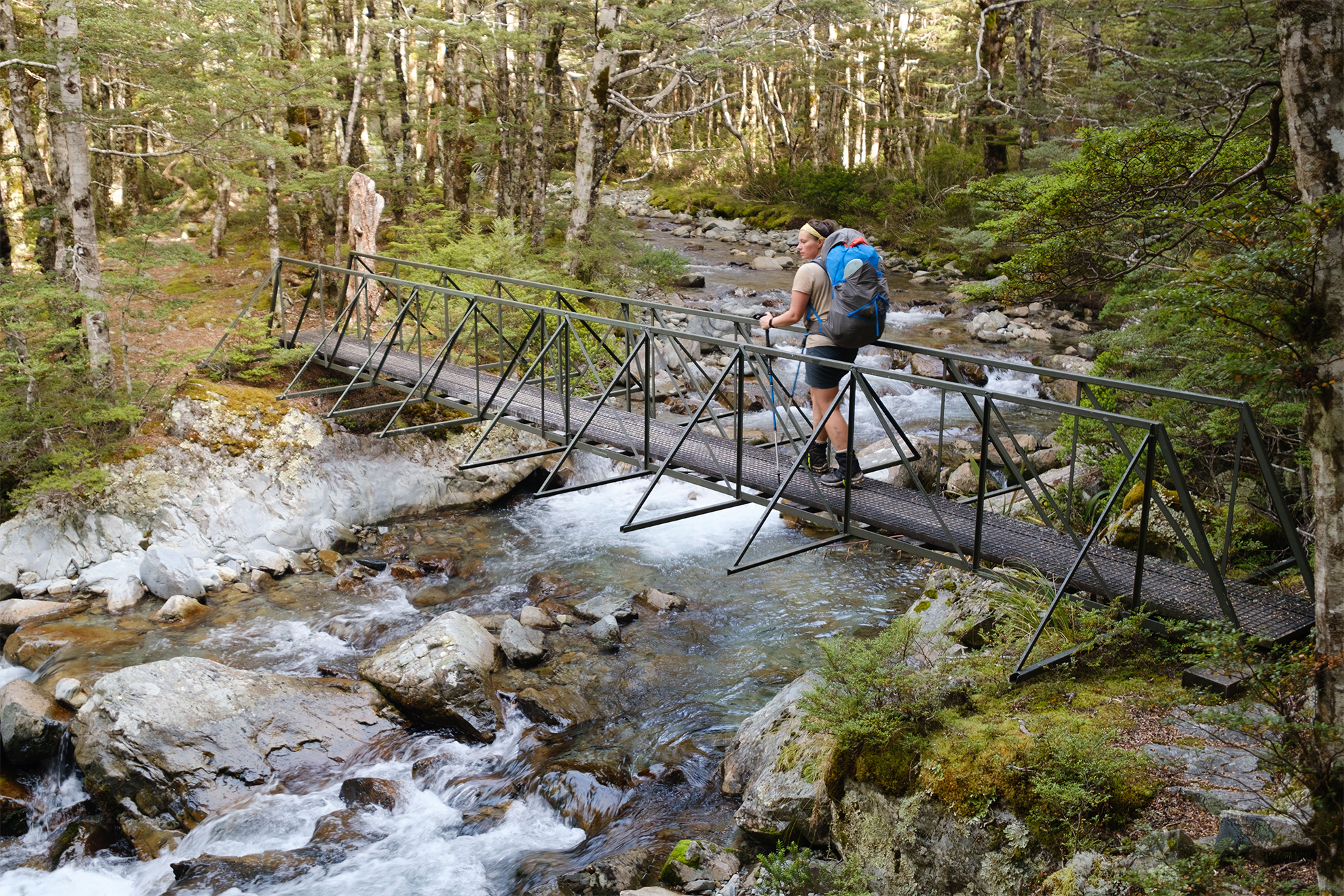
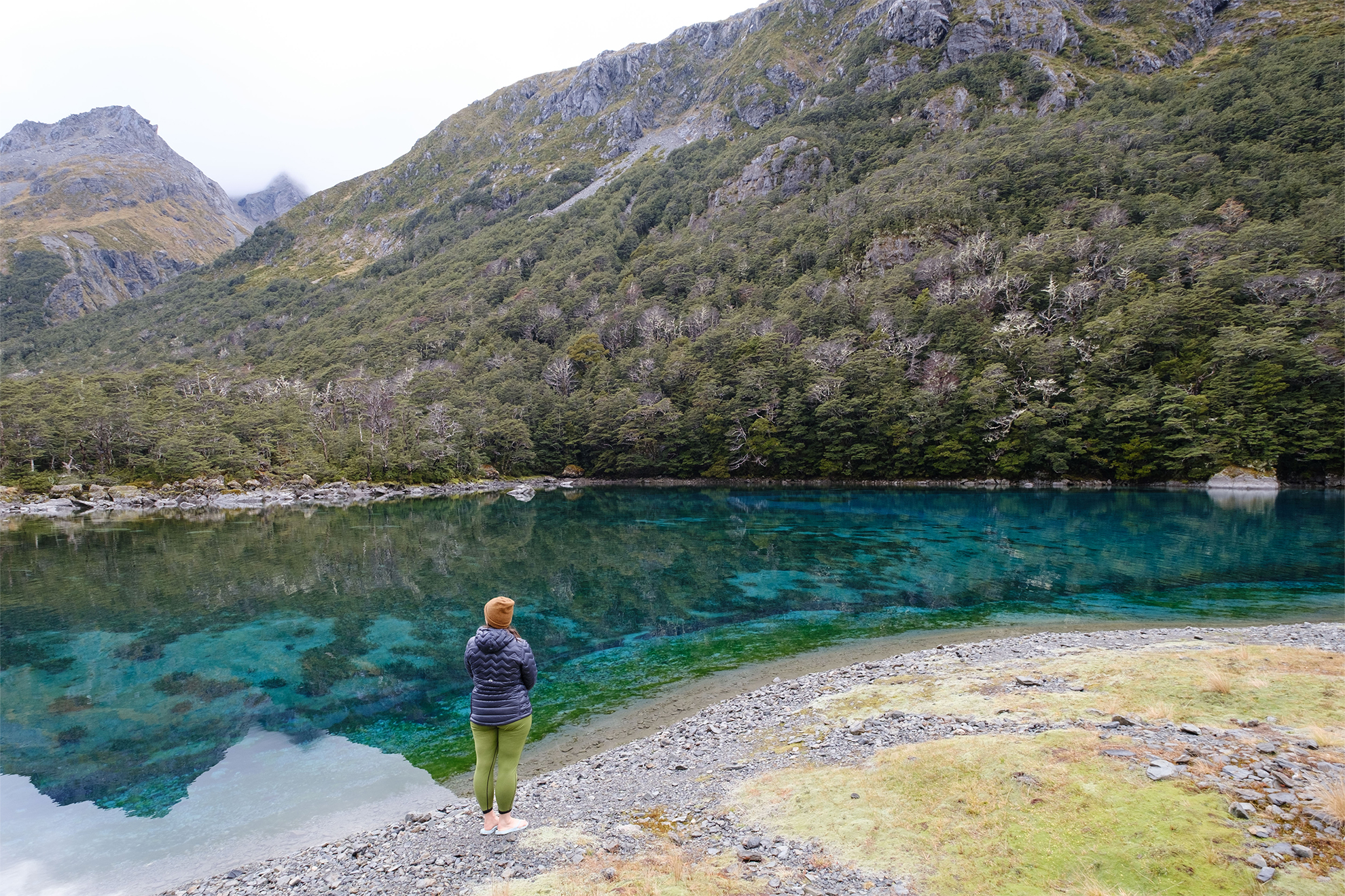
So we pack out. The terrain is beautiful yet treacherous, and the broad slips, hazardous roots and mossy boulders demand attention on the gradual valley climb. We beat the rain to the hut, so pop out to see Rotomairewhenua / Blue Lake before sunset. Fading light and rain disturb the lake’s surface so conditions aren’t ideal, yet it’s stunning.
Hours later, at the hut, torchlight sweeps across windows to announce three bedraggled northbound Te Araroa walkers. The billy goes on and stories are shared, but our tiredness wins and the hut falls silent long before 9pm, save for the sound of rain on the roof.
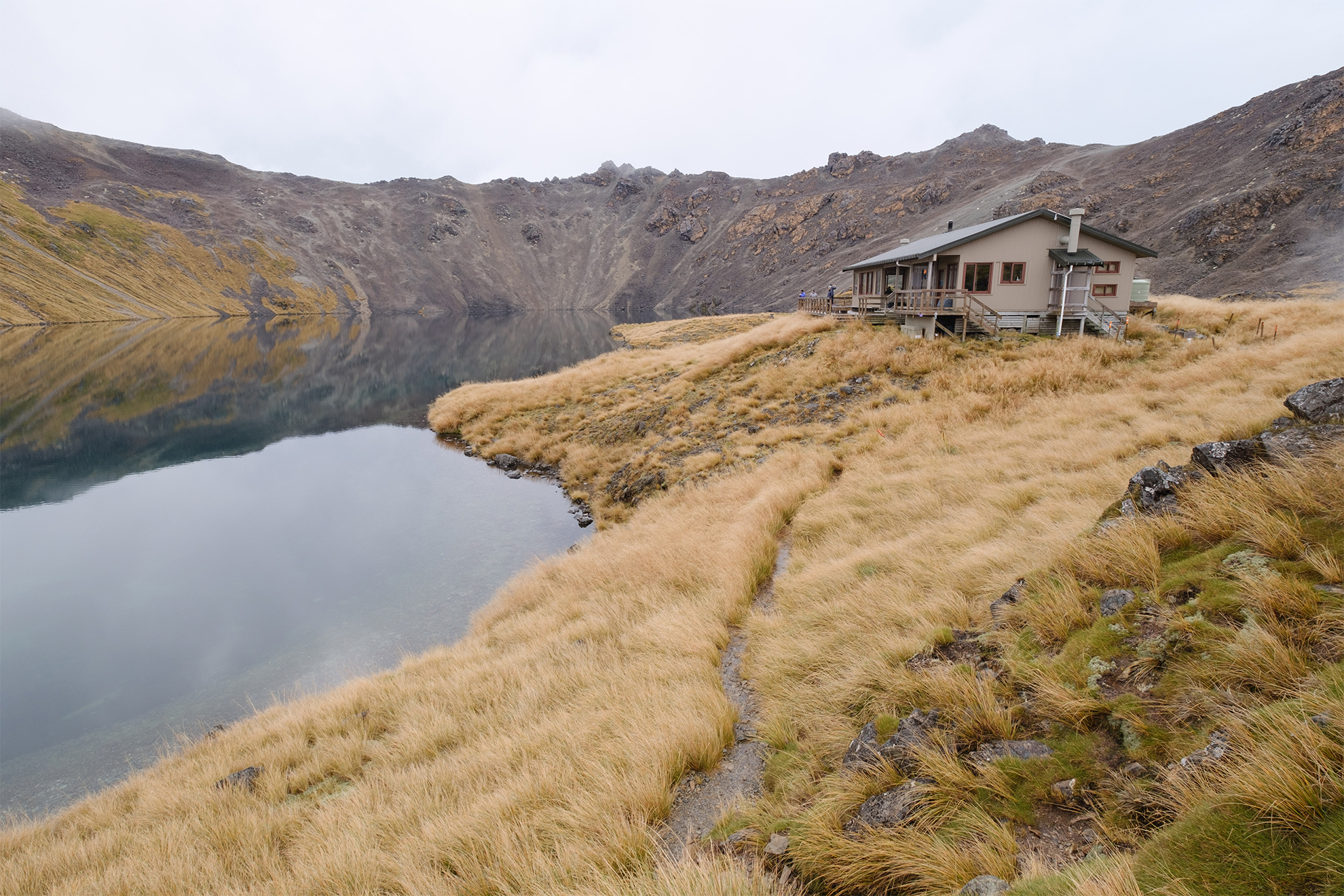
Rotomairewhenua beckons shortly after dawn. With a brighter sky and no rain or wind, the lake is breathtaking. Mirror-calm and impossibly vibrant, it’s not easy to capture the scene with photos or words. The lake’s clarity means visibility into its water nears 80m; it’s claimed to be the clearest freshwater on earth. It’s tapu to Ngāti Apa ki te Rā Tō, and was once used in ceremonies to cleanse the bones of men to release their spirits for the journey to Hawaiki. Lake Constance, Rotopōhueroa, cleansed the bones of wāhine. Neither, therefore, can be touched. Good thing too – it should not be tainted by footprints, waste and lost GoPros.
Beneath ominous clouds we chance the short climb to Lake Constance lookout, having read handwritten directions pinned to the hut wall. The 1.5hr return track leads us onto a vast landslide separating the two roto. It’s well worth the detour.
Lake Constance is the largest alpine lake in Aotearoa, dwarfing Rotomairewhenua, although nowhere near as brilliant. For 10 minutes we stand at the lookout, watching the darkening sky turn the lake slate grey beneath Franklin Ridge. A kārearea flies overhead to perch high on a boulder, silhouetted against the impending storm. I don’t believe in omens, but it’s clearly time to go.
We pre-load a hot hut lunch as threatening fronts swoop up the valley. Twenty minutes later, we lace up and walk headfirst into a thunderstorm. The first rumbling is distant and I’m not convinced it isn’t imagined, but the second rattles my bones. We count seconds between flash and thunder as it marches overhead, bringing rain so heavy it infiltrates my gaiters, drips down my legs and soaks my socks. The Sabine River rises quickly, and adrenaline shifts us into an extra gear. With a gentle descent and a hut beckoning, I experience a squelchy synergy with the track as we barrel down it, sky splitting overhead.
In three hours we arrive, like wet dogs, at West Sabine Hut, occupied already with familiar faces and new. Soaked clothes orbit the woodburner, hanging above steaming mugs of tea and soup. A brazen mouse blows its cover one too many times and is chased out in a sudden burst of scraping furniture, stomping feet and shooing fingers. Excitement over, we down dinner and get ready for bed while hut banter dissipates to whispers. Sabine River, so gentle the day before, now sounds like radio static as it lulls me to sleep.
Light rain persists through to morning, and river and track, in places, are synonymous.
Sabine Hut is empty when we arrive, and we enjoy our private lakefront manor. The 32-bunk hut is metres from Lake Rotoroa and guarded by a swarm of peeping pīwakawaka, wheeling in pursuit of sandflies. Everything is damp. The persistent rain has invaded my pack liner, soaking my sleeping bag and food.
We stoke the fire, monopolise the drying racks and settle into our books.
The rain eventually breaks and we visit the hut’s pier to stand in meditative quiet. I close my eyes and count every sound I notice. It’s a mindfulness technique I use in the hubbub of city life. Faraway rivers lay a bed of white noise and raindrops plummet from overhanging trees into the shallows. Local korimako have perfected an eerie five-note motif, which they echo to one another across the forest.
The morning defies the weather forecast, and our now well-oiled machine means we’re packed and fed within 45 minutes.
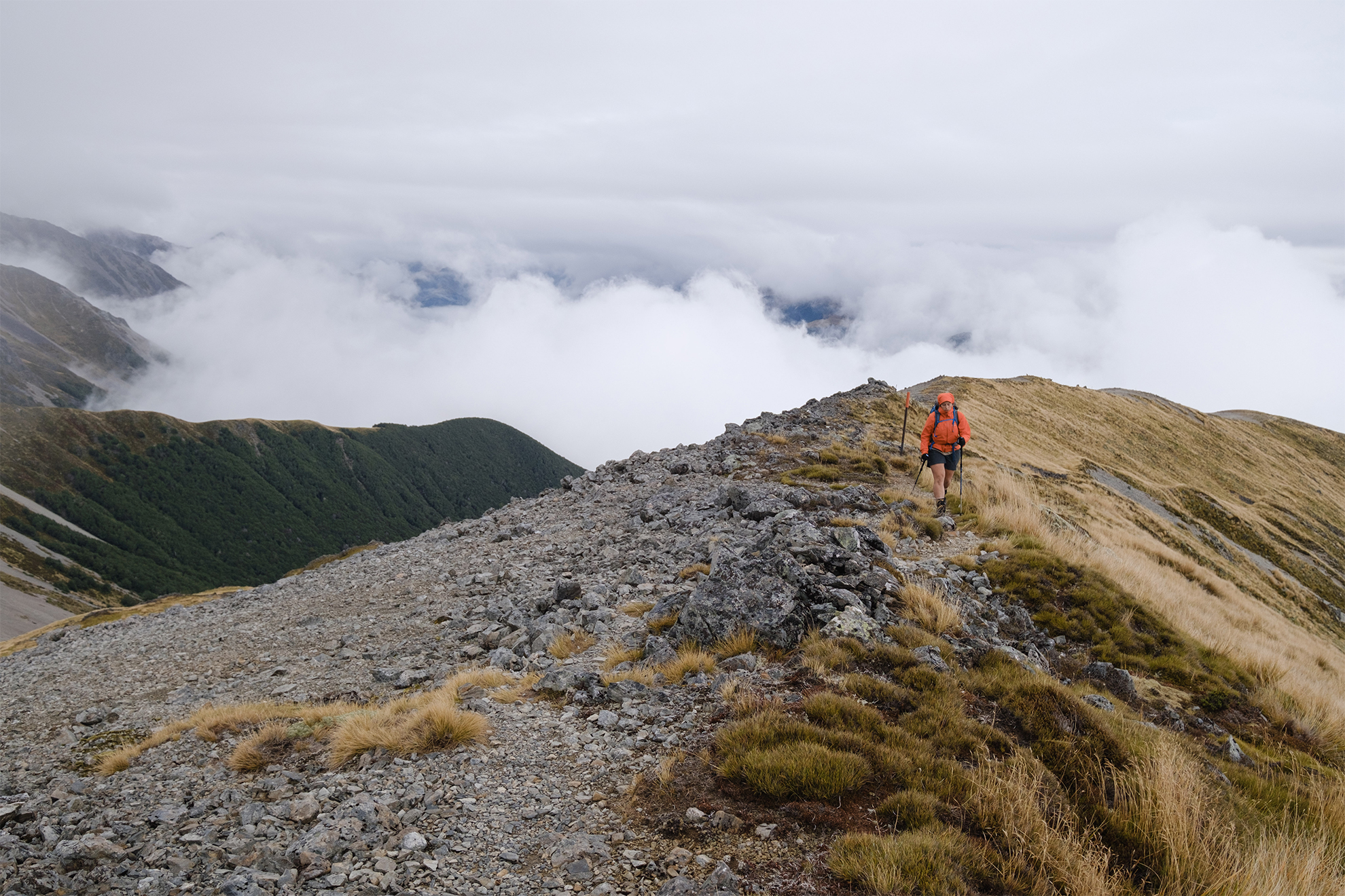
If you can’t find humour in the Mt Cedric Track, you’ll cry. The track launches up a comically steep, muddy slope. Switchbacks? Never heard of them. For nearly 1400m it’s relentless, sheer enough in parts to deliver a deep stretch to your calves. After more than two hours through uneventful bush, a sign warns of the upcoming alpine section to Angelus Hut – a several–hour mission over exposed ridges, boulders and landslides. ‘You are here,’ the sign taunts, with a small dot placed just halfway up the bushline section. “That’s impossible,” I grimace, consulting my navigation app. Sure enough, our position puts us a stone’s throw from the bushline, which we reach moments later. The sign is totally inaccurate, and a real buzzkill if the real position cannot be checked.
A low ceiling of cloud brushes our hair as we burst from the bushline and continue climbing. The Cedric route is exposed, and so far we haven’t met the expected rainfall. There are fleeting glimpses of Lake Rotoroa when the cloud clears, but I feel we are missing much of the magic.
The track keeps things interesting, however, crossing slips and sidling along ridges. I mistake Hinapouri Tarn for Lake Angelus, but the day is not over and a slow scramble over slippery boulders prolongs the final kilometres into a test of patience – too slow and we’ll freeze, too fast and we’ll fall.
We finally reach Angelus Hut an hour ahead of DOC time. With only a few stumps left for the wood burner, cold visitors have been rationing wood for the evening and the common area is icy. We change from our wet gear, layer up and settle in for soup, cards and catch up with friends we’d arranged to meet here. The reunion and the treats they brought (chips and red wine) provided the morale boost we needed on the disappointingly cold afternoon.
On a good day it’s hard to beat Angelus Hut. I last visited nearly a decade prior under a cloudless sky with fresh snow dusting the surrounding peaks. But that’s tramping, right? You never step in the same river twice.
With the fire finally lit, we jog in our underwear to the smaller of the two lakes for a dip, and though it sucks the air out of my lungs, it feels wonderful afterwards.
In the morning the mountains lose their patience and serve us a final eviction notice. Light, persistent rain douses our spirits as we climb out of the Angelus bowl onto Robert Ridge. Through momentary gaps in the whiteout are glimpses of the route’s famed views, but only enough to bestow a sense of unfinished business.
As we round Julius Peak the wind becomes biting, and within 10 minutes my fingertips are numb. Agustina pulls spare socks over my fingers, tucking them beneath my rain-jacket cuffs. I wrap my new flippers around the walking poles, put my head down, and off we go to the bushline. It’s an unceremonial and disappointing end to an unforgettable adventure, yet it’s always nice to leave a few stones unturned.