“WhaaAAT?” I screamed, trying to make myself heard above the rolling waves of wind and rain; the gun-cracking nylon of our tent. A faint cry had emerged from Rik’s tent but then flown off into the valley. He tried again. The same words had rung out before, and would again before we reached our journey’s end: “I’M PACKING UP!”
A bloodless dawn was creeping through the fabric after another wild night. Grant and I felt a little more secure in our sturdy dome, but Rik was not so sure his lightweight job could take the strain. With a week still to go, it was no place to lose a tent. Rik had spent most of the night sitting up, braced against the pole. Apparently he didn’t want to hold it up any longer.
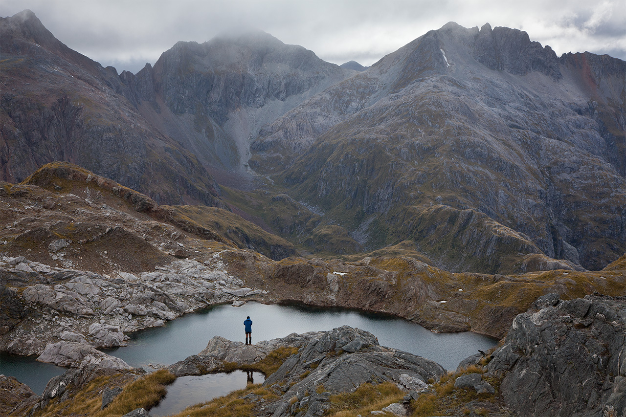
“Okay. Us too!” I yelled, as Grant and I slowly roused to the task. It was our highest camp in weeks of walking, 1500m up on an unnamed shoulder of an unnamed mountain on an unnamed range in the tangled hills of southern Fiordland. And I wouldn’t have been anywhere else for quids.
Standing around would be dangerous, so we crawled out of the tents together, jammed them into our packs and got away fast. Battling wind-blasts, eyes stinging, we stumbled over rocks and around a knoll, into a wind-shadow. Then we could pick our way down a rocky cirque-wall above the North Branch of Florence Stream. Soon we were in relative calm, on easy ground, and could enjoy a stroll along the floor of the hanging valley, graced with brimming streams, rich green moss and wildflowers. After just an hour we camped again, in the hope that another day would see us clambering in sunshine along the high ridges. It was a peaceful place to reflect on both where we wanted to go next, and how far we had already come.
I first devised a plan about 30 years ago, inspired by the isolation and gothic name of the Dark Cloud Range, and by the gobsmacking glory of Fiordland’s mountains. With their wind-tossed tussock, scoured rocks, rolling grassy tops and a cornucopia of lakes, the lower ranges lend themselves to long, adventurous walks above the bushline – of a sort that can be relished in few other places in the world. There’s only one real problem: the sand flies…no, wait, I meant to say the weather. Yes, the weather. Of course.
I was camped at Mt Cook when Three Johns Hut blew away in 1977, and in the Olivines when 24 inches of rain flooded the West Coast one day in 1982. I knew what weather was. And I’d spent cut-glass days high on the bevelled ridges of the Darrans. I knew what the potential was.
From a hub where the Dusky Sound Track crosses the Main Divide, ridges spoke out south-west and south into the fiords. One of these spokes is formed by the Heath Mountains and then the Dark Cloud Range. The plan was to traverse these hills from the coast to Lake Manapouri. February is the driest summer month, on the numbers, so that was when we took our chances.

A half-day break in the weather let us fly out of Te Anau. Water was gushing off the mountains on all sides as the pilot dodged between clouds. Since landings are not allowed in the South West Cameron Remote Area, we placed a food cache at the top of Long Sound and flew to South Port in Chalky Inlet. Later, a helicopter on its way to Supper Cove would hide another stash near Lake Roe Hut. We had 28 days for what we figured was a 14 day walk: plenty of time for side trips.
South Port was cold and showery, but with most of the day left we pitched camp and crossed the swampy peninsula to explore the more sheltered coastline of Preservation Inlet. The Cameron Mountains ranged across the eastern sky, beyond blue water fringed with yellow sand. We strolled along beaches and marvelled at limestone stacks, soaking up the almost tropical ambience. Next day we made a quixotic dash to Gulches Head to tag the actual coast, then saddled up for the serious business and a long climb into the mountains.
I still see Treble Mountain as one of the most beautiful hills we crossed, with its tussock locks waving in the misty showers, gold in bursts of sunshine, and deep blue fiords to left and right. Ahead, the Dark Cloud Range proper rose in spiky waves, drawing us on into the heart of Fiordland. But first, the range inconveniently dived back down to sea level.
As we left the tops I was confronted with the radical discrepancy in our equipment. I caught up to Rik and Grant standing together, pointing out landmarks ahead. One of their packs was half the size of the other.
Rik Deveridge, encouraged by an old leg injury (not from the outdoors), is a featherweight fiend. He was good at scampering across the mountains and often could be found gazing at the view while waiting for his more ponderous and wrinkly colleagues. Grant and I were slowed not just by heavier packs, but by a shared distraction for gathering photographs. Rik granted us great forbearance.
Grant Dixon, a Tasmanian through and through, had solid boots and waterproofs, ate big and carried up to 30kg on the walk. Blue Mountains Rik had about half that weight, wore sandshoes and fed himself like a bird. I, being such an average and moderate person, was somewhere in-between. The pros and cons of our different styles supplied a rich vein of repartee and various consequences. Regardless, we all lost several kilos of body mass.
At the end of that long day and thousand-metre descent we were close to Cliff Cove and exhausted. The grumps were beginning to poke through the veneer of civilisation. A kilometre short, tangled in a maze of lumps and bumps, we gave up and camped in a rimu bog. Just as well. In the morning we burst onto the cobbled shoreline to find the water reaching out unrippled beneath a smooth grey sky. Islets were mirrored in perfect reflections. But the place was utter misery. Through the silence a faint hum could be heard, and then we were running around the shoreline plucking sandflies from our ears and blowing them out our nostrils. In Australia they say that’s why Kiwis are such hard trampers: they have to keep moving from dawn to dark. We wouldn’t be rid of the infernal creatures until we reached the lofty heights of 1300m, weeks later.
After climbing back onto the range we welcomed another rainstorm and our first rest day. Soon we would not be so sanguine. The weather harried us as we worked northwards along the gradually rising tops. It changed nearly every day, sometimes twice, in a parade of small fronts and rain and bursts of sun. Any attempt at prediction floundered in the atmospheric chaos. I was reminded of Charlie Douglas’s advice that the barometer doesn’t affect the weather much on the coast.

The Dark Clouds began with some ‘goblin’ forest, then a sharp and sinuous ridge where low clouds played a veil-dance with the dark sounds to either side. We descended into the bush only once more. From Needle Peak we dropped into a valley that drained into Long Sound to collect our food drop. It took a whole day, which despite light packs was the toughest of the trip. While I was trying to scrabble up a steep wall by scratching at roots and ferns I heard a muffled crash from behind. Rik was down and groaning, bounced between rotten logs. Grant helped him out while I retreated. Rik had landed on the side of his chest and later assured us he’d broken a rib. He was okay while walking, but slept painfully for the next couple of weeks. By the time we staggered back into camp that night, soiled and thrashed, we had agreed that the ‘weather option’ of walking up Long Burn was to be avoided like a disease.
Rik’s was not the only injury. Later, leaving Staircase Saddle, we opted to sidle around the top of a big hill through stunted forest. You know the kind, where greasy-poles hang out sideways from slippery rocks, and the only way through is to twist into gymnastic contortions at risk to life and limb. For Grant it was a limb. He slipped and wrenched his arm out of the socket, badly spraining his shoulder. After that, with two wounded walkers, we looked aghast at the slightest hint of bush, or Green Hell as we came to call it, completely denying its ethereal beauty.
My companions were tough bastards. While I just suffered routinely, they plugged on with acute injuries for the rest of the tramp. They didn’t even seem to slow down. Luckily arms weren’t needed much because the going was never technical, with only occasional grass-pulling.
Sunburn was never a problem either, but we did have two glorious days heading for the Lake Mike area. It was the best weather of the trip, and although we arrived too tired to nip out to Perpendicular Peak, Grant and I climbed some sharp summits nearby. We could look eight days back to Treble Mountain, north to Crowfoot, Black Giants and the Merries and straight down 400m onto our camp where Rik was trying to dry his feet.
The rain came again so we pushed on, nearly getting blown off the ridge near Prong Lake. Apart from plenty of time, another key to staying high was being willing to scurry along in marginal weather, even if only a short way. Although we traversed many fine summits en route, we bagged few of the major peaks we wanted. One success was a dash out to Mt Solitary (1454m), the apex of a chiselled ridge of white granite. Perhaps partial success is more accurate: it fogged in before we got there. But it would have been superb, I’m sure. And we paid for it, by having to descend a feared slope into the saddle at the head of Long Burn in cloud and drizzle. At last, we’d passed the threat of Green Hell, and were just a long day from Lake Roe over the benign Heath Mountains.
Mt Solitary was a big day, among many big days, as we walked 12km (some without packs) and up and down over 1400m. We needed a rest, and the Long Burn saddle was a fine and friendly place to have one. In fact it was so good, and the weather so shifty, that we spent three nights there, with the tarns, the ducks, the gardens…and the sandflies. We heard a kiwi calling in the night, but didn’t notice the Christchurch earthquake.
Before we got to Lake Roe the weather went funny again and produced our third fine day. Three! We sauntered light-packed and shirt-sleeved over the pleasant Pleasant Range to the empty hut in the most threatening weather we’d seen: utterly blue and windless. It couldn’t last, of course. But hopes ran high anyway, as we watched the orange sunset spread across Lake Roe. The Merrie Range looked grand. We wanted to be there. For us photographers it was an excellent show, and our last.

Under a morning sky of curdling grey, and weighed down with another week’s food, we climbed quickly onto the range. A rain-front raced us to the crest, rolling in over the western ranges. It won, and Rik had to shed a tear for his second turnaround on Tamatea Peak. There was little talk. We rugged up and descended northwards into a massively cliffed lake basin. It was a strategic retreat; we could still go high another day. The character of the country changed abruptly. It was higher, spikier, bleak and dramatic, bare and glacier-scraped. Snowbanks, even. Grant was beside himself: “The best country we’ve seen!” We dared not linger.
Getting back up the other side was the biggest unknown of the whole route. It looked scary in real life too, especially through the showers: huge bluffs everywhere with barely a dint. So we dropped packs and hunted a few lines. Three options, all with nasty bits. We lunched and pondered. I suggested that a narrow chasm might appeal to Rik, a canyon explorer. It ran straight up the mountain like a fault line, which is exactly what it was. But it wasn’t too exposed, and it was dry after the rain had backed off.
We scrambled up easily for a long way – further than we needed to, because we couldn’t get out. Until a vertical step forced us out onto the left wall. The rock was shattered, but an adequate stairway. It looked like we could soon reach easy ground. On and on it went, until we finally scrambled out onto walking ground. Rik turned to me and said: “I knew when I went with you guys that I’d end up doing something like this.” But he was grinning.
We were about to head off when Grant, still on the bluff, said quietly: “I can’t step up here.” He needed two arms to take some of the lift, and only had one that was useful. Rik and I couldn’t help: it was no place to be taking his pack off. So we fretted as Grant, an experienced climber, tried different moves. He found a combo that worked and climbed neatly up to us.
We rose higher, into the barren zone below a nameless 1660-plus metre peak. We’d regained our lost height and were again in a position to continue along the airy ridges. If only. Amongst tarns and shattered, white-veined rock we found two little pads of moss that would hold our tents. Dramatic peaks rose all around, propping up a foreboding sky. But outside our sheltered nook the wind could blow you down. And that’s where we came in….
Once we abandoned that camp, we never got high again. Showers and thick cloud blew past relentlessly. We moved on slowly as the days leaked away in the rain, linking high basins with easy passes, always hoping that the mad idea of reaching Wilmot Pass might again seem possible.
Our third camp from Lake Roe was perched on a shelf not far from a mountain with an actual name: Ward. It was the wildest night of all, and Rik’s plaintive cry again broke with the dawn. We made yet another strategic withdrawal. Thick snow was falling as we skidded down towards Lake St Patrick. We could barely see. One gust sent all three of us sprawling. In the valley, we cowered all day as polystyrene pills piled up around our tents and smothered the peaks.
Squelching and shivering, we crossed into the lovely Diamond Creek cirque. There we made our last stand. It was still possible to cut back onto Mt Ward, maybe, while the Dusky Track was beckoning from the shadowed Spey Valley like a dark temptress. In the morning the snow was melting upwards but gales and water still poured across the sky in a dark boiling tide. We stood and looked at each other, hovering on the green edge of hell. Are we going up? Or are we going down? The spirit was still keen and the flesh stronger than ever, but hope was cowed and beaten. Reality insisted: we were out of time.
Under dark clouds, we took a last look around at that wild and glorious alpine world and stepped into the sodden bush.

34 years of inspiring New Zealanders to explore the outdoors. Don’t miss out — subscribe today.

Questions? Contact us


