
To mark Wilderness magazine’s 30th anniversary, current and past editors and contributors scoured the archives for the 30 best trips we’ve published over the decades. This story, original published in September 2012, was included. You can find all 30 of the greatest Wilderness trips in the October 2021 issue.
We stared into the shattered heart of the Southern Alps. Towering above us was the crumbling, rivulet-streaked north-east face of Mt Burns; 2000 vertical metres of fragile rock, broken part way with a shrinking stone-flecked glacier. Below, at Burn’s base, the McKerrow Glacier gnawed slowly at the mountain’s foundations, carrying them into the head of the Landsborough Valley. To the north the Douglas névé, cloaking Mt Sefton’s western slopes, shimmered in the late morning sun. Karangarua Saddle’s distant tussocked slopes and the patchy alpine plants on the slopes we’d climbed to Douglas Saddle added yellows and greens to a colour palette that is dominated by the blue of the sky, the white of the snow and the grey of the rocks.
Silence surrounded us, interrupted only by the occasional clatter of shifting stones and the vaguest of breezes over the pass. We snacked without speaking, awed by the rawness of New Zealand’s Main Divide and contemplative of our route onwards up the shadowy schist of The Gladiator.
For several years a Mt Cook topomap had adorned my wall at the New Zealand Alpine Club offices. West of the Divide and alone on a remote moraine flat at 1200m sat one of those ‘bowler hat’ dots denoting a rock bivouac. Titled Harper’s Rock Biv, this spot of black ink, incongruous among the map’s lines of orange and blue and far from the green, tempted me. A remote refuge for generations of transalpine visitors, the bivouac was first discovered by AP Harper – one of the co-founders of the New Zealand Alpine Club – in the early 1890s.
Harper’s legacy in the Westland alpine region is significant. In 1893 he joined the Department of Lands and Survey as an assistant to the legendary explorer Charlie Douglas and between 1893 and 1895 explored the Franz Josef and Fox Glaciers and several major rivers, documenting his findings in a series of fascinating and entertaining New Zealand Alpine Journal articles. He learned to live off the land, surveyed the mountains, took many photographs and studied glaciology. According to historian Graham Langton, Harper’s ‘greatest trip’ was a traverse, with Ruera Te Naihi, of the Karangarua and Landsborough Valleys, with many side trips. The journey entailed a massive 19 weeks in the mountains, with the duo subsisting on cached rations, supplemented by a diet of whio, kea and kakapo.
I wanted to see Harper’s namesake bivouac for myself and planned a round trip that would traverse some stunning alpine terrain: we’d walk in via the Lower Karangarua, over the Conical Hill traverse route to Horace Walker Hut, into the head of the Douglas Valley and the rock bivouac, then over Douglas Saddle, the rocky flanks of The Gladiator, Karangarua Saddle and out down the steep and rugged Karangarua Valley; a trip of six days.

We watch a high over the Tasman progressively intensify until the weather maps showed nothing but clear skies and widely spaced isobars over the whole of the South Island. Not only were we getting a head start on our annual Easter transalpine trip but we had an unbelievable weather forecast to go with it.
The emerald Karangarua, low in flow after a prolonged dry spell, rushed beneath the swinging car of the cableway as the four of us – one by one – crossed the river en route to our intended bivouac on Conical Hill 800m higher. The cableway’s a relic from the deer culling heydays of the 1960s and 70s and reminds us that this is big hunting country. The Karangarua in particular is known for epic herds of Himalayan tahr.
Being beyond the Karangarua was like crossing a threshold, as we left behind the preamble of the lower valley flats and entered a steep world of moss-festooned boulders, gnarled bush and babbling side streams. The noise of the Karangarua faded as we gained height up Regina Creek. Higher, we crossed the creek via a swingbridge spanning a gulf between house-sized boulders and climbed steeply to Conical Hill, arriving just on dusk. Like dogs looking for a pole to pee on we searched until we found a favourable spot to drop our packs and lie for the night. An infinite starry sky is revealed above us and we eat and sleep where we sit, content among the tussocks and hebes.
Morning reveals a paradoxical vista as we gaze up the Douglas Valley towards the Main Divide – our destination. This far above the valley, the scene has a fairytale beauty and tranquillity to it, but lurking in the early morning shadows are endless cliffs and a deep and twisting gorge, filled with the freezing waters of the Douglas River as it carries its load of glacial till from Douglas Lake to the surf of the Tasman Sea. Our route bypasses this gorge via some exposed ridge travel and then a high traverse on broad tussock benches that takes us to the brink of the Horace Walker Glacier moraines, where we descend to the open flats surrounding Horace Walker Hut. The tiny hut is occupied with hunters, who generously share their swag of fresh tahr meat with us. We spend the night on the grass outside the hut, waking to white all around us as a heavy frost grows on the valley floor.
We’re away at first light, boulder hopping as we approach Douglas Lake. Dreadnought grey and freezing, the waters reflect the massive schist ramparts either side of the lake. Framed at its head is the moraine terrace and Harper’s Rock Biv, and beyond that the upper névés of Mt Sefton glow gently in the early morning light. We feel tiny; swallowed by rock and insignificant. We linger at the lake outlet, taking photos, gazing at the view and revelling in the uniqueness of it all.
Getting from the lake’s outlet to the rock biv is the crux of the trip; there’re bluffs to negotiate and any route description we had read has to be taken with a pinch of salt in this dynamic landscape of ever-shifting rock and ice. We boulder hop along the lake’s true right at water level until a cliff forces us to climb up crumbling moraine walls. Gingerly we kick steps into the steep rock-studded loess until we can gain a terrace high above the water. It takes us two goes to find the route off the terrace and through another line of bluffs which brings us onto more steep, crumbling moraine. Very carefully we probe sideways along the giant slope looking for a safe lead onto expansive rock slabs above the Douglas Glacier.
Once on the slabs we drop our packs and eat, relaxing a little with the precarious route finding behind us. Beyond, we’re faced with a geological spectacle of such awesome proportions that it’s hard to describe. Even Harper struggled. The zenith of the scene is the summit of Mt Sefton, lofty above us at 3151m. Sefton’s summit snows descend to terminate in a series of terraced cliffs. These merge into the Douglas névé; a gigantic expanse of pristine white, riven with jumbled seracs and crevasses. The upper edge of the névé is framed with Sefton and the Sierra Range, but the lower edge has no gentle transition to scattered ice blocks; instead it’s forced off an overhanging cliff, 400m high and three kilometres long. Giant blocks of ice perch on the brink and gushing melt water streams fountain off the edge, their droplets forming rainbows.

Below us, and fed only by the ice that tumbles from this cliff, sits the Douglas Glacier, isolated from its source névés and apparently fighting a losing battle with a warming planet.
From our perch on the slabs we suss out a route onwards; down through gentle moraine walls and diagonally across the glacier. From there we climb a steep streambed descending from the Harper Rock Biv moraine shelf in baking heat. We soak our sun hats in the chilled water in an effort to cool off and slowly zigzag up the hill, looking forward to the shade of the bivouac.
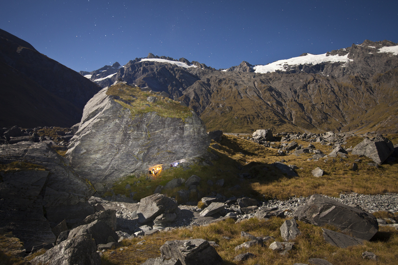
Harper’s discovery does not disappoint. Between two dry streambeds towers the boulder. We circle it and on its north-west side find two sleeping niches; one large enough for four or five people, with shelter from all but the meanest of storms. The other is more exposed but lighter and brighter, too. We settle in and are soon snoozing on the flat sunny rocks of the riverbed; loving being in an historic place, in perfect weather and only halfway through the trip. A second dose of tahr meat augments dinner and we sleep satisfied.
We cross the flat valley floor the following morning with our eyes set on the steep climb to Douglas Pass. To our left lies the Main Divide and a string of iconic peaks south of Mt Sefton. The one that captures our attention the most has a 1300m-high face, overhanging in sections, that falls from the summit right to the valley floor just 1500m from where we walk. It’s the south face of Mt Thomson (2642m) which, still unclimbed, has to be one of the greatest remaining prizes in the Southern Alps. Averting our gaze, we start the climb to Douglas Pass under yet another perfect blue sky and after a couple of tricky gully crossings make it to the pass. For a long time I’d wanted to stand there, near the source of the mighty Landsborough, among this stark, pristine, mountain heartland. It’s hard to take it all in: the expanse of Mt Burn’s north-east face, the distant outlines of Mt Hopkins and Dark Tower and overlapping ridges vanishing into the haze as the Landsborough slowly descends to the bushline.
In the distance, the gentler contours of Karangarua Saddle beckon. We’ll be there in a few hours, but we have to traverse The Gladiator (2125m) and Mt Howitt first. Some circuitous route finding has us wandering through mazes of broken schist and climbing small bluffs until we find some snow leads that will take us right and back onto the summit ridge. With crampons on, the firm névé crunches underfoot and once over a couple more rock steps we’re traversing the mellow ridge to the summit; high in the sky and laughing at the beauty of it all.
From the highpoint of the trip the journey unfolds beneath us: the first night on Conical Hill – so distant now – to the traverse to Horace Walker. Douglas Lake shimmers and we pick out our route through the bluffs to the slabs, across the glacier and up to the biv. Beyond we can see deep into the Karangarua and to the remote peaks on its far side.

The route to Karangarua Saddle over Mt Howitt is mostly quick and easy, except for a short section of icy bluffs. Schist flakes tile the ridge and make travel fast. Eager to make the long descent into the head of the Karangarua before it gets dark we skip the saddle and shortcut across rolling tussock.
Afternoon mist has filled the valley and on the brink of descending into it we take a bearing, aiming to hit a creek below some huge cliffs under Mt Townsend. The scrub’s not as bad as we expect and following occasional animal trails we finally reach the stream, where travel is steep but quick with only brief detours into the tangles on its edge. On the Townsend side of the creek avalanche debris is piled up in places.
It’s growing dark when we pick up the first route marker near the valley floor and after 12 hours on the go we finally see Christmas Flat Hut emerge from the mist. The small hut is empty, welcoming and we’re stoked to have it to ourselves, not yet being ready to share the solitude of our experience with others.
We’re unsure what the next day will bring. According to Moir’s Guide North there are some dodgy sections and we get an early start, not being sure how long the day will take. The track – the first one we’ve walked since we left Conical Hill three days earlier – has been upgraded and we walk, alone in our thoughts, without having to make route finding decisions. Occasionally, spectacular streams, which have cleared swathes of bush from the slabs, cross our path. The water runs from pool to pool and reveals gleaming quartz bands sandwiched in the schist. The pools are idyllic and gentle after the harsher world of rocks and exposure we’ve become accustomed to in the previous days.
Fiordland-like, the Karangarua Valley descent is a grand finale to our tour. Steep walls rise up on either side and deliver an uncompromising rawness that accompanies us until we return to the river terraces of Cassell Flat. All that remains is a five hour walk to the road.
Unlike Harper’s 19 week odyssey, ours is only six days but the experience of venturing into such awe-inspiring country has left indelible memories and leaves us wanting more.
Wild file
Access Park at the Copland/Karangarua Valleys parking area (Rough Creek). Haast Highway.
Grade Difficult
Time Six days
Map Topo50 BX 14, BX15, BY14, BY15
Further Information The route is marked as far as Horace Walker Hut, although there is no track along the high traverse from Conical Hill (occasional poles only). Returning down the Karangarua Valley, the track is marked from Christmas Flat Hut all the way out. Alpine route finding skills, ice axe and crampons essential. Consult the latest edition of Moirs Guide Northfor more information.


