
We are geographically embarrassed. The luminous beams of our headlamps light up the swingbridge dangling across the river, but there is no sign or obvious track to the nearby hut. The descending darkness has reduced our vision to a pathetic circle of torchlight. What should have been a straightforward stroll to the hut has become an embarrassing epic – it’s easy to miss track markers and misread the map at night. It’s also painstakingly slow going over the rocky and rooty track sided by steep drop-offs.
Malcolm and I had trudged up the track alongside the Wairoa River with twilight biting at our heels. Exhausted, we just want somewhere soft to lie down; a brief touch of comfort in a warm mug of tea. When we stumble into the ageing shanty at Mid-Wairoa at 9pm, dinner is long overdue and the air temperature is a tropical zero degrees.
The following day starts with a deserved sleep-in. Long tramps often seem to start slowly, as the body gets accustomed to pack-carrying and the legs get used to the punishment. By the end of our tramp we will both be well-oiled tramping machines.
We are in Mt Richmond Forest Park, on the long pathway that is the Te Araroa Trail and a spectacular 4–5 day circuit nicknamed the Alpine Route. Highly underrated, this loop is, perhaps, the best kept secret in the top of the South.
Across the bridge, the well-marked trail climbs steeply up the valley wall for a couple of hours, finally emerging from the dark shadows onto an 800m knob. From here the barren Red Hill can be seen to the south-west – a distant massif of serpentine rock devoid of any vegetation. At a signed junction, an undulating sidle track leads off towards Tarn Hut – this diversion gives our screaming quad muscles some reprieve. A kereru darts and fantails flit. Malcolm spots a quartet of goats before we continue our intrepid journey upward.
Through thinned, shaggy beech forest we amble, along a carpet of moss. Another DOC sign leads us off the main ridgeline to find the five-bunk Tarn Hut nestled in a large clearing. It’s a New Zealand Forest Service S-70 design and like all the nearly identical huts visited on this trip has its own quirks and idiosyncrasies. The adjacent lakelet is bathed in blazing sunshine, so we waste an afternoon there drinking tea and reading. All is quiet except the buzz of insects and the chortle of a lone tui.
I chop firewood to stoke the Oregon potbelly while Malcolm chops salami for dinner. Later, the fire is lit to heat the hut and then we snuggle into our sleeping sacks.
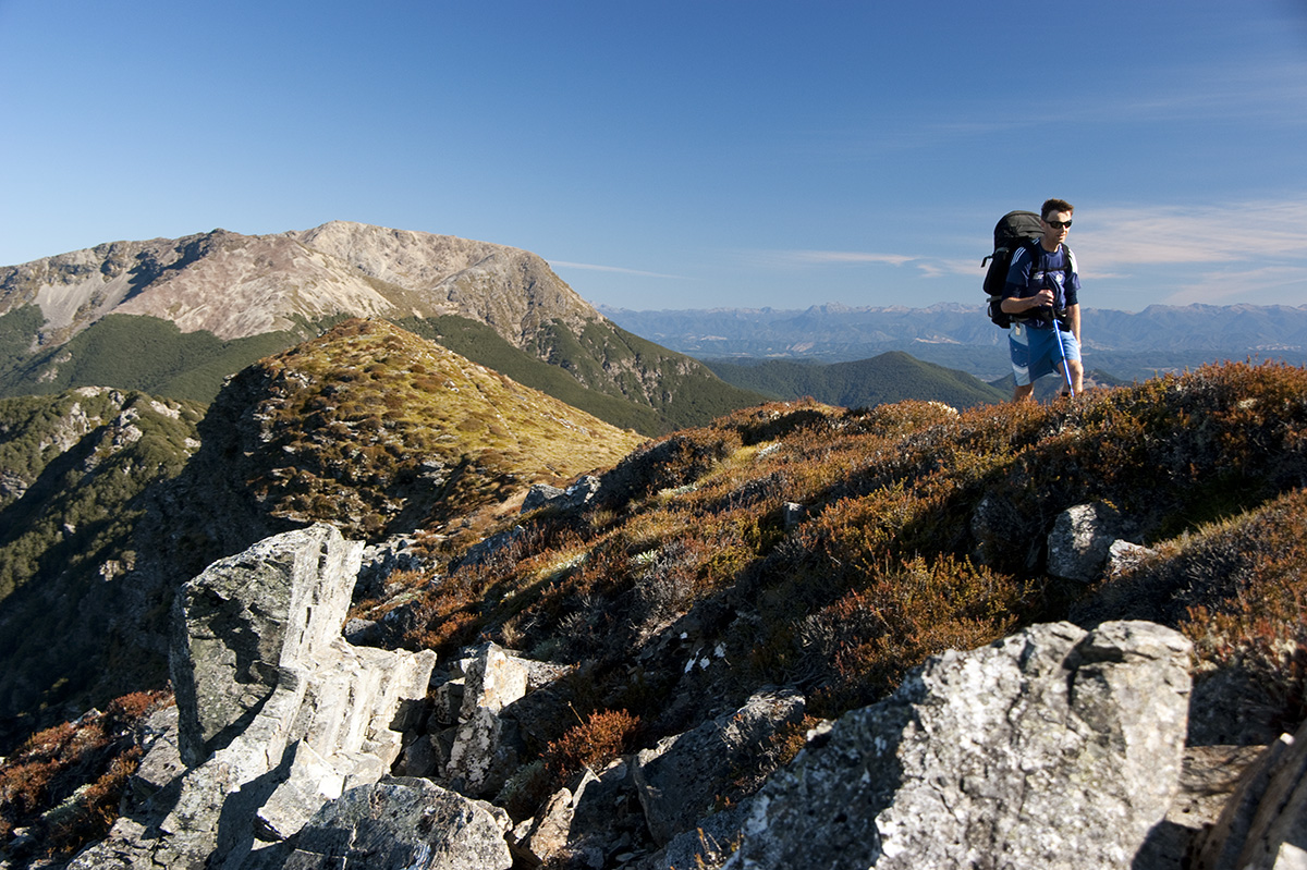
We anticipate a long struggle over four mountains so make an early start the next day. Bellbirds sing and the autumn sun attempts to warm us as we enjoy the pleasant ridge-top ramble. I am photographing the view towards Ben Nevis when a herd of wild goats suddenly bolts into the bush below.
At the turn-off to the Lee Valley, I dump my pack and make a lightning ascent of Bishops Cap, a perfect pyramid of rock that stabs into the sky at 1425m. Meanwhile, Malcolm has passed me and it’s not until the cairn at Purple Top (1532m) that I finally catch up. From here, colossal views of the west face of Rintoul, with its diminutive dollhouse visible in an obvious clearing below, unfold. Looks are deceiving and it takes a full hour to reach the tiny Mt Rintoul Hut; a real gem of a place with a tangible sense of exposure.
Alas, time is ticking on, so we scramble up scree slopes onto the shattered tops of Mt Rintoul (1731m). Our jubilation is momentarily interrupted when the route is blocked by an improbable rocky gendarme. This obstacle is negotiated with a short sidle beneath it to regain the ridgeline; then Rintoul is ours, a mere stroll along the slanted plateau.

By the summit cairn we snap photos and absorb the expansive panorama in all directions. Further east, the rocky profiles of Mts Richmond, Fell and Fishtail remind me of earlier trips. To the north, lie the island peaks of Mts Starveall and Slaty, part of tomorrow’s itinerary. The distant snows of Mt Tapuae-o-Uenuku are vaguely visible to the south. Even Mt Egmont shimmers over the Taranaki Bight.
The day is ebbing away like an outgoing tide, with the worst section of the route still waiting for us. Hastily, we drop down a narrow spur; a toe-jarring descent to the saddle with Little Rintoul. We have read rumours of parties being stranded here in thick mist for two days, unable to find a way out, and aren’t keen on doing this by torchlight. The poled route skirts below crags, with shingle slides providing dubious access to the bushline. Marked with snow poles, a random maze of chutes and guts leads upward – these would be dangerous in winter. Exhausted, we eventually arrive on top of the sharp, unstable rock piles of Little Rintoul.
The colours of dusk are vivid as I follow Malcolm’s silhouette across the tops, down a shingle slide on the east face, dropping 500m to the bushline. A steep, zigzagged path winds through darkening forest, skirting a large tarn, to the welcome refuge of Old Man Hut.
After eight hours on the go, my mate is a spent force. I cut firewood and make the meal. It is great to be back here, as memories come flooding back of the previous year’s attempt on the Alpine Route. I had limped in from the Goulter River after tearing a tendon in my knee. Reluctantly I devised an easier circuit to Lake Chalice to lick my wounds.
We opt for a sedate start; our leaden limbs are hammered after yesterday’s venture. A humorous photo is composed of we two ‘old men’ sporting ‘old man’s beard’ moss appendages, framed by Old Man Hut. In a good mood, we sing our way onto the ridgeline, walking a delightful trail through stunted beech on a carpet of moss and fallen leaves. Two craggy knobs are negotiated; one requires us to step along ledges but there’s nothing too scary or airy.
Two hours have passed when we reach the tussock top of Old Man (1514m), breaking into full von Trapp chorus. A black barrel here is the sole source of water. Sheltering on the lee side of the summit, we enjoy a leisurely break. We are now safely over the crux of the route and the forecast predicts more picture-perfect weather. We take in the vista toward Mt Patriarch and back to Little Rintoul, diminished in stature, vanquished behind us.
Bluffs are avoided by carefully spotting the snow poles down to the bushline and through forest canopy, up to the sloping alpine herb fields of Ada Flat. This tussock plateau proves a delightful romp, albeit in strong winds. A handful of unnamed peaks are crossed en route to Slaty Peak (1544m), which my companion climbs while I boil a billy in nearby Slaty Hut. We whittle away a couple of hours reading through 10 years’ of tramping history recorded in the visitor’s book. Our feet ache, but we are feeling fit and energised by the stunning scenery which surrounds us.
Orange lollipop markers lead over a lip and down an easy forest trail to the saddle which links Slaty Peak with Mt Starveall. This section is true magic, with its gentle gradient, shelter from the wind and ever-present birdsong. A short, steep slog onto the northern shoulder of Starveall leads to stupendous views over the Waimea Plains to Tasman Bay; beyond, the Arthur Range is etched along the horizon, stretching from Mt Owen to Mt Campbell. The sun sinks lower in the sky, making us squint. We can spot the hut far below in a scrubby saddle.
A serrated spur of slabby schist drops in a dress circle to Starveall Hut, our shelter for the night. As the Milky Way burns through the southern sky, Malcolm recognises the distant lights of Motueka; beyond this, we can make out the penetrating beam of the lighthouse at Farewell Spit.

Mt Richmond Forest Park is spotted with huts. As I lie in my pit, I muse that even though it’s holiday season, we have not seen another soul. There is also a dearth of reading material in each hut – only DOC publications and the ubiquitous ‘Six Pack’ of novels. As candlelight flashes off the anorexic hut walls, I listen. There’s not a telephone ringing, nor a television blaring. A morepork hoots above the incessant wind which rattles the tiny hut with determined venom. I fall asleep.
After a fitful night, Malcolm coughs himself awake and makes us a cuppa. We take time to eat, pack, and photograph the hut, putting off our inevitable return to the city. Although clouds are building in the sky above us, the day holds promise of more sunshine.
The track from Starveall Hut descends abruptly in a series of switchbacks through broken beech, devastated in the snows of a recent winter storm. Thankfully, DOC has remarked the track. We continue our controlled descent, losing 1000m in the first hour. The second hour is spent sidling through mixed podocarp and beech forest behind Pyramid Rock, parallel to Hacket Creek, then boulder-hopping over many river crossings. If the Hacket is running high, this section would become impassable.
Hacket Hut is a sorry affair, its proximity to town giving vandals access to it. Though dark and uninviting, we use the shelter for a lunch stop and chat with a father–and–son duo who have mountain biked in. A detour to Whispering Falls is made to bide our time, as we are early for our pre-arranged pickup.
Closer to the car park, we pass scores of day trippers – a stark contrast to the solitude we have enjoyed during our journey across the mountains; where people are as thin on the ground as the air we have sucked into our lungs. We have thrived on five days’ of hard tramping and risen to the challenge. We have bagged seven small huts and climbed over seven big summits. Now, with our return to civilisation imminent, we reluctantly, but proudly, head for home.


