Image of the February 2011 Wilderness Magazine Cover Read more from the
February 2011 Issue
Home / Articles / Features

Beacons from a bygone era

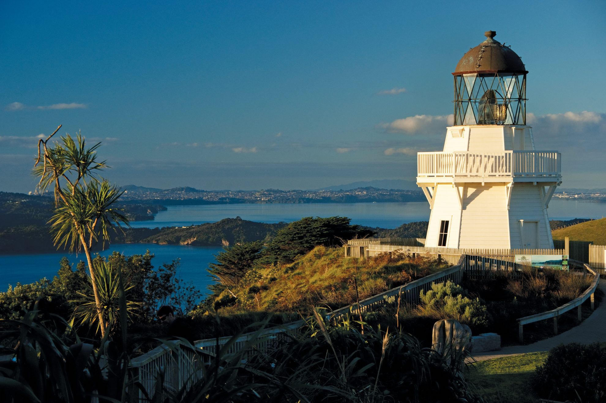
Lighthouse enthusiast Raymond Salisbury guides us on 10 lighthouse walks 

Built during the late 1800s when sea transport was the norm, New Zealand’s 40-odd lighthouses were a bastion of human civilisation in an otherwise inhospitable and lonely environment. They epitomise a time when most people lived near the coast and the country’s economy revolved around shipping. Lighthouses predated both aeroplanes and vehicles, so their keepers were usually supplied from the sea.

To sailors and seafarers, fishermen and immigrants, lighthouses represented a return to civilisation, a symbol of their homecoming. Today, those same lights represent remote, rugged outposts – usually visited on foot, which now seems somewhat ironic.

While there are no lighthouse keepers left, as all manned lights were automated by 1990, the romance of living at such an isolated place can still be experienced by staying overnight in DOC huts at Kahurangi Point, Cape Brett and Tiritiri, which are converted keeper’s quarters, and also on the private Cape Campbell Walkway.

My own interest in lighthouses was sparked by visiting two of them in 1995. I embarked on an ambitious tramp across the central North Island, starting at the East Cape lighthouse, and finishing at Cape Egmont lighthouse, 80 days later. My affinity for these pillars of nostalgia has grown as I have managed to visit and photograph more than 20.

Many lighthouses have now been restored as historic icons, and most can be accessed via walkways which meander along dramatic clifftops or razorback ridgelines. A few more can be visited by boat, or kayak. Yet, however you choose to visit there will be a taste of wilderness, where the land ends, pounded by the Pacific or turbulent Tasman.

Featured on the following pages are 10 coastal adventures at the edge of New Zealand’s earth.

  1. Manukau Heads, Awhitu Peninsula, Auckland

Set in a spectacular location on the South Head of the Manukau Harbour, this lighthouse was finally erected in 1874 to safeguard shipping to Auckland, but a decade too late. In 1863 the navy corvette HMS Orpheus hit the Manukau Bar and 189 sailors drowned in the racing tide, making this the worst shipwreck in New Zealand history.

The old lighthouse was abandoned to the elements in 1986, but nearby is one of the few manned signal stations still in operation. Many families lived out here. Indeed, by 1895, the school roll recorded 21 children.

A local trust has recently built a faithful replica of the original 1874 wooden tower. It’s not a working model, but is open to the public. Climb up the spiral staircase, past the gigantic lens and admire some stunning 360-degree views from the balcony: across to Destruction Gully and the Waitakere Ranges and down to the black sands of Whatipu, Ninepin with its smaller light, and Paratutai Island, site of the original signal station. In the distant haze is the Sky Tower and beyond that, Rangitoto Island provides a familiar backdrop. Look out for the rare Maui dolphin in the water below.

  • Access About 1.5hr drive from Auckland, via Waiuku and the Ahwitu peninsula.
  • Time 3min from car park up to lighthouse.
  • Grade Easy
  • Map Topo50 BB31
  1. Bean Rock, Waitemata Harbour, Auckland

Bean Rock is our last surviving wave-washed lighthouse. Originally marked by a red pole and black buoy, the current beacon was built in 1871 by W. Cameron (the same builder who constructed the lighthouse at Manukau Heads). It was an identical twin to the light at Ponui Passage, further east. It’s named after Mr Bean, a ship master who assisted the harbour survey in 1840. This lighthouse was completely renovated in 1985.

Kauri poles support a hexagonal cottage, with a wrap-around verandah and corrugated iron roof. The first keeper, Mr Hugh Brown, lived there for 19 years! He lived inside three rooms: a kitchen-living area, a bedroom, and a ‘long drop’ to the sea. In a small rowing boat, Brown had to regularly commute to his family at Devonport – a daunting prospect in foul weather. A son relayed messages to his father by morse code.

This wooden tower is a comforting waypoint for kayakers paddling to more distant shores.

  • Access By kayak. Nearest put-in is Kohimaramara Beach. The Fullers Coffee Cruise regularly passes by Bean Rock.
  • Time 20-30min
  • Grade Easy
  • Map Topo50 BA32
  1. Tiritiri Matangi Island, Hauraki Gulf, Auckland

Located 4km off the end of the Whangaparaoa Peninsula, Tiri was farmed for 120 years and stripped of 94 per cent of its native bush. It is now administered by DOC and over the past 25 years volunteers have replanted approximately 300,000 trees. The island is now 60 per cent forested and home to many endangered birds such as kokako, saddleback, takahe and stitchbird.

The lighthouse was built in 1864 and is the country’s oldest operational lighthouse. Its 20m cast iron tower is the twin to the one at Cape Egmont, rising 91m above the water.

An ironical misadventure happened here in 1883 when the steamer Triumph ran aground directly below the lighthouse. The helmsman had been instructed to ‘steer by the light.’

The last keeper was Ray Walter, who remained on the island as a conservation officer when the light was automated in 1984.

Near the 21m tower are two modified keeper’s cottages from 1918. Visitors can stay in the bunkhouse which has hot showers, fridges and gas stoves. Book by prior arrangement with DOC. Rangers are resident on Tiri and guided tours will help identitfy rare birds.

  • Access Fullers Ferries regularly visit Tiritiri from Auckland. Gulf Harbour Ferries depart from Whangaparaoa
  • Time 30min to lighthouse from ferry
  • Grade Easy. Suitable for children, though mountain buggies are preferable to pushchairs. BYO food and water.
  • Map Topo50 AZ32
  • Guided walks www.360discovery.co.nz
  • Accommodation www.doc.govt.nz/tiritiribunkhouse
  1. East Cape, Eastland

Go here early and you will see the light first, from the eastern-most point of New Zealand. The lighthouse was originally erected 2km away on East Island, but it was threatened by slips and was difficult to access. Indeed, during the construction phase, four men drowned when their boat capsized in heavy seas. By 1906, the cemetery had seven graves, including three of the keeper’s children.

So in 1922, the Marine Department moved the cast iron tower to the mainland. High on the crest of a hill, this place is popular with sightseers wishing to see the sunrise. If you explore the ridgeline you’ll discover relics and remnants from the old station buildings. Wear warm clothing, as the hillock is exposed and watch out for black cows if you’re driving in the pre-dawn murk.

  • Access From Te Araroa and SH35, take East Cape Rd for 25min to the end. Behind the keeper’s cottage are about 500 steps leading up to the lighthouse
  • Times 20min one way, but allow more time to explore this wild place
  • Grade: Easy
  • Map Topo50 BD95
  1. Cape Egmont, Taranaki

Originally prefabricated in London, this lighthouse was assembled on Mana Island in 1865, but caused confusion and possible shipwrecks. So, in 1881, the cast iron tower was shipped aboard the tender Hinemoa to this desolate, windswept cape.

Nearby was the settlement of Parihaka, home of the non-violent protester Te Whiti. These Maori believed that the land was tapu. They caused havoc with local settlers, ploughing up farmers fields and obstructing the lighthouse construction. In November 1881, 1500 troops invaded Parihaka, Te Whiti was arrested, his village destroyed, and his followers dispersed.

By 1951 the light was electrified and by 1986 it was automated. Ironically, on the very first night after this, the automatic light failed.

From the summit of Mt Taranaki/Egmont you can spot this lighthouse, a white pillar on the hazy green and blue circumference that circles the province. It’s worth a visit to the Cape, but it would be prudent to ask for access permission at the keeper’s cottage. Climb up to the lighthouse for a view of Mt Taranaki.

  • Access From New Plymouth drive 45km on SH45 to Pungarehu. Turn right into Cape Rd for 5km
  • Time 5min
  • Grade Easy
  • Map Topo50 BJ28
  1. Matiu/Somes Island, Wellington Harbour

Matiu Island was renamed after Joseph Somes from the infamous New Zealand Company. After the light at Pencarrow Head was established, a second signal was needed for navigation, so Somes Island was selected. The lighthouse was constructed in 1866, but was not powerful enough and was replaced in 1900 with a round brick tower.

Between the 1870s and 1920, the island was used as a quarantine station, usually for animals, but sometimes to separate humans from infecting the general population. People died here, and there is a monument to their memory. During the two world wars the island was used for military purposes. Five concrete anti-aircraft gun emplacements still squat defiantly against a feared Japanese attack.

Since 1995, Matiu/Somes Island has been open to the public and a relatively easy walking track circles the entire perimeter. A short detour leads to the rusty lighthouse. Two keepers lived here with their families in a six-room cottage.

For several decades the island has been a sanctuary for native plants, birds and insects. Look out for red-crowned parakeet, robin, kingfisher, shags, and little blue penguin. Several species of weta are protected here, along with skinks, gecko and tuatara.

East by West ferries provide regular drop-offs. You can also kayak or row a dinghy, but you must land near the wharf and check your boat for stowaway rodents. Being a scientific reserve, there are strict access restrictions for other vessels. Contact DOC if you wish to stay overnight in the houses or at the campsite.

  • Access East by West ferries. See www.eastbywest.co.nz
  • Times 30min to lighthouse
  • Grade Easy
  • Map Topo50 BQ32
  • Accommodation www.doc.govt.nz
  1. Baring Head, Wellington

Situated on the south-eastern headland of Port Nicholson, Baring Head is an iconic Wellington landmark viewed by hundreds of ferry and airline passengers each day.

The lighthouse was built in 1935, replacing the original light at Pencarrow Head. It was the first lighthouse to run on mains electricity and was automated by 1989. It was designed as an ‘approach light’ for ships in the harbour, and also as a ‘coastal light’ for vessels in Cook Strait.

At least 40 shipwrecks were recorded on the wild coast between Eastbourne and Baring Head.

Several rare plant species are found here, plus the only mainland black-backed gull colony in the region. Cook Strait blue penguins breed here while variable oystercatchers and banded dotterel are also present. There’s also the rare spotted skink, Maori cicada and katipo spider.

Earlier last century, only four categories of visitors were allowed to stay overnight – those on official business, or formally approved by the Marine Department, ‘belated or distressed travellers’ and ‘shipwrecked mariners.’

In June 2010, the Greater Wellington Regional Council jointly purchased land adjacent to the lighthouse (with DOC, Nature Heritage Fund, Hutt City Council and a private contributor). A decision is yet to be made whether the 1930’s houses will be preserved for recreational use. This development is part of the East Harbour Regional Park, and will allow public access onto the lighthouse reserve.

  • Access From Wellington, drive 40km east to Wainuiomata. Follow the Coast Rd south to the beach. You may have to wade the river mouth which is tidal, en route to the rock climbing area
  • Time 30min
  • Grade Easy
  • Map Topo50 BQ32
  1. Boulder Bank, Nelson

The Nelson Provincial Council built New Zealand’s second lighthouse in 1862 on the Boulder Bank, a natural breakwater to ‘the Haven’. This rocky finger of shattered granite is 13km long, starting from ‘The Glen’ and ending at ‘The Cut’. It’s 55m wide at high tide and varies from 6–25m high. It was formed by the movement of granite and other igneous rocks eroding from Mackays Bluff by sea currents moving southwards.

The octagonal cast iron tower was made in Bath, England. The longest serving keeper was John Kidson, who lived there for 27 years. He rowed his 10 children across the bay to school, except “when the weather was rough”. However, by 1915 both cottages were removed and the light was automated.

During the Second World War, the threat of a Japanese invasion prompted the port authorities to extinguish the light. Port Nelson has recently decided to re-light this beacon at Boulder Bank. When this is implemented, the lighthouse will project its beam over Nelson City.

It takes a couple of hours to reach the lighthouse, which stands 18.3m. The track passes by a number of old rustic baches in various states of disrepair. When their current owners expire, their lease expires and the buildings must then be removed. Eventually, the Boulder Bank will be in the hands of its original custodians: the seagulls, oyster catchers, seals and shags.

  • Access Drive 5-10min from Nelson along Boulder Bank Drive, off SH6. The lighthouse key is available from Port Nelson, which controls the port environs. In summer, boat trips can drop off sightseers
  • Time 2-3hr
  • Grade Easy. Boots recommended
  • Map Topo50 BQ26
  • Key Port Nelson, P: 03 539 3841
  1. Cape Campbell, Marlborough

Guarding the southern entrance to Cook Strait, this lighthouse was built in 1870. At least 18 shipwrecks were recorded on this treacherous coastline between 1845 and 1947. Cape Campbell was chosen to site a new lighthouse after the notorious wreck of the whaler Alexander in 1858. In 1871, the Rifleman went down with the loss of all hands.

Unfortunately, by 1905 decaying timber meant a replacement tower had to be constructed. Black bands were painted on white to ensure that the new tower was visible against the white hills behind it.

While it is now possible to drive to Cape Campbell, the coastal journey begins at Marfells Beach. This is the route by which early keepers travelled by horse and cart to collect their mail.

As the crumbling cliffs at the end of the beach are difficult to negotiate, you must time your visit with the tides. This also applies at Snapper Point, where only a narrow margin of dry land is left at low tide. Further on, access to Cape Campbell is across private land. Farm gates should be left as you find them.

While it took me two hours to trek along the shingle beach to the Cape, you should allow more time to explore the lighthouse and the heavily eroded white papa cliffs. History records that the first keeper, William Hendle, died of a heart attack inside the lamphouse in 1881.

If you wish to stay overnight, contact the landowners. The private baches here have all the home comforts a bedraggled wanderer could want, including power, hot showers, fridges and microwaves. These old cottages are used for the second night’s stay for walkers on the Cape Campbell Walkway.

  • Access Travel on SH1 for 36km south of Blenheim. Just south of Lake Grassmere, turn left into Marfells Beach Road. Drive 8km to the shelter at the camping ground. Route is not marked
  • Time 2hr at low tide
  • Grade Easy
  • Map Topo50 BR29
  • Info www.capecampbellwalkway.co.nz
  1. Cape Foulwind, Westport

In 1642 Abel Tasman anchored off this cape, naming it Rocky Point. In 1770, Captain Cook wasn’t impressed with the atrocious weather, coining the name Foulwind. However, this treacherous coastline hasn’t actually claimed many ships. Nevertheless, in 1876, a hexagonal wooden lighthouse was erected, its kerosene lamp dutifully guiding sailors to the Buller River mouth for a century. Fifty years on, it was replaced with the present concrete tower.

A well-graded and surfaced pathway meanders over the headland, skirting the old lighthouse. It provides a panorama from Mt Cook, to the Paparoa Range, to the Denniston coal plateau. Weaving among rock promontories and tenacious scrub, the white walkway continues to climb between sheer cliff faces and fenced farmland. Long ago, pioneer settlers had milled the taller timber and burnt the land for grazing. Remnant vegetation includes flax, cabbage tree, kawakawa and mingimingi.

After about an hour’s amble a viewing platform is reached. Far below, seals lounge in their rookery. They breed between mid-November until January, so summer is a great time to visit.

From the seal colony, a path suitable for wheel-chairs follows the coast south to the car park at Tauranga Bay – this is where you find most of the tourist traffic.

  • Access Drive 11km south of Westport on SH67, past Carters Beach. Turn right at a junction, drive 1km to a car park above Gibsons Beach
  • Time 5-10min to lighthouse; 1.5hr to Tauranga Bay
  • Grade Easy
  • Map Topo50 BR20