A standout tramp for its coastal views, lush bush, protected wetland, black-sand beach and ingenious track design.
Zion Hill Track, closed in 2018 to manage the spread of kauri dieback and to repair subsequent storm damage, reopened in early 2026, creating more options for walkers near Auckland.
Before setting off, look for the pou whenua of Kōwhatu ki te Uru, an ancestor of Te Kawerau ā Maki, mana whenua of the Waitākere Ranges. Unveiled in 2003, it’s the work of master carver Sunnah Thompson.
Cross the bridge over Company Stream and veer right through Pōhutukawa Glade. Zion Hill Track is to the left, 300m from the start.
Pass through the cleaning station and begin a steady ascent on the well-formed, stepped path. It follows an ancient trail to Pararaha Valley, which was a mahinga kai for mana whenua.
On the climb, pause to look down at Karekare Beach and Te Matua The Watchman, an 80m volcanic dome on top of which Kōwhatu ki te Uru built a fortified pā, Te Kākā Whakaara, in the late 17th century.
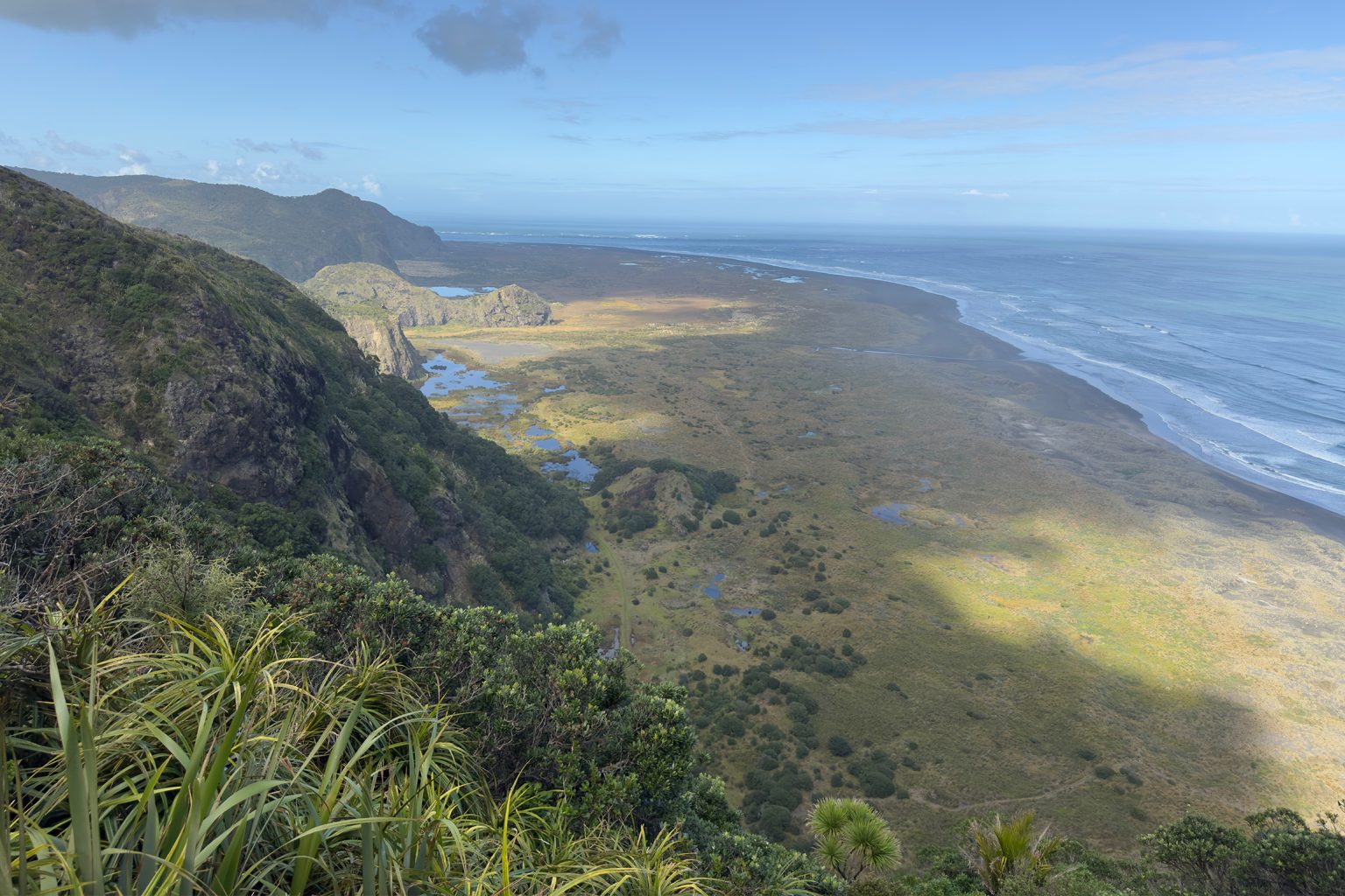
At 1.7km, close to the highest point on the trail (Mt Zion, 263m), a lookout offers expansive views southwards across Cowan Bay to Tunnel Point. From here it’s a gradual descent on a mix of gravelled track and an impressive series of elevated boardwalks, designed to keep walkers off the kauri roots while providing safe passage across land plagued by slips and subsidence.
Particularly striking is a section at 3km that meanders through a stand of young kauri, some of the larger specimens on Zion. The hills here were stripped of big trees during extensive logging in the late 1800s and early 1900s, and it is encouraging to see so many thriving again. The track descends through densely forested gullies and across a couple of streams where the likes of punga, taraire, kawakawa, nīkau and pūriri abound.
At 4km a platform with seating – shaped rather like the prow of a waka – points through trees to the Tasman Sea. The track drops sharply now to meet the Whatipū–Tunnel Point intersection (4.65km). Turn right to cross the boardwalk through the wetland, part of a 742ha scientific reserve that stretches all the way to Whatipū.
Once across the wetland, cross the dunes following sporadic orange markers. It can be hot work on the soft black sand. At 6km, head right at the marker to Tunnel Point Campground and a historic tunnel, once part of a tramline that transported kauri between Karekare and Whatipū. Beyond the tunnel is a grassy path that turns to sand as it crosses the dunes.
There are options to head along the beach here, but you would then miss the dune attractions that seem to change on every visit. After rain, water sometimes pools, creating a haven for shore and wading birds, and between September and February there is a chance to see dotterels and their nests.
To get around Karekare Point comfortably, choose low to mid-tide. The sight of Paratahi Island signals you’re almost ready to head inland on the dune track back to the car park.