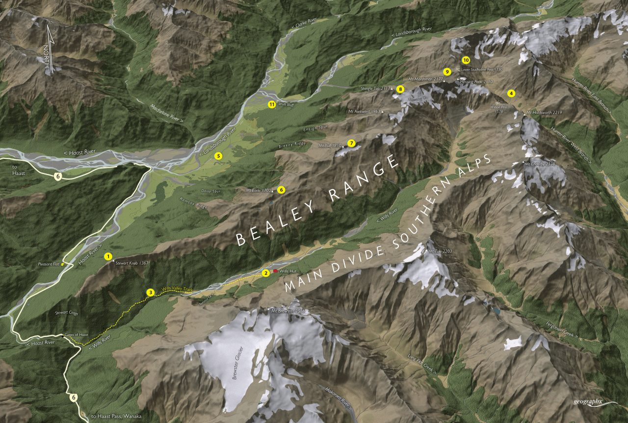
The Bealey Range is South Westland is both accessible and incredible…
High above the Gates of Haast on the Haast Pass Highway are the fearsome Stewart Crags – an almost 1000m wall of forest and cliff rising sheer from the Wills River to the crest of the Bealey Range. The range, which terminates its westward push here, continues east to merge with the Main Divide near Hassing Peak above the upper Hunter Valley.
For nearly its entire length, it is traversable and offers some outstanding trip options between the upper Wills and lower Landsborough rivers. This is further enhanced by the fact that neither river needs to be forded to make for an exciting and moderately challenging crossing from one valley to the other – or to enjoy some of the best scenery South Westland has to offer.
The range is littered with tarns, small snowfields, modest summits, numerous campsites, and has reasonable access from both the southern and northern sides.
1. Stewart Knob and Crags
This incredible viewpoint is just 1139m in altitude but looks directly onto the Gates of Haast Bridge at a meagre 200m altitude. Some scrambling may be required to traverse Stewart Knob (1367m) to reach the cliff edge. Take care here.
2. Wills Hut
The only hut located anywhere near the Bealey Range is Wills Hut, a standard four-bunker resting on a grassy terrace on the south side of the Wills River. It has views of the range and is a good stopover point for trips further into the valley.
3. Wills Valley Track
The Wills Valley Track climbs steadily into the upper valley until the hut is reached. Above here, there is no marked trail, but numerous deer trials will lead adventurous parties to the valley head. The upper valley is impassable during and after heavy rain.
4. Wilson Pass
The standard high route in and out of the Wills is via Wilson Pass (1578m) between the Hunter River West Branch and upper Wills. It is moderately challenging, requires good navigational skills, and can be dangerous when snow covered.
5. Landsborough Valley
The lower Landsborough runs beneath the northern face of the Bealey Range and has easy access along a 4WD road as far as Strutt Bluff, providing an assured exit route for those who have descended Daisy Spur or Ramsay Ridge.
6. Mt Earle
This 1700m summit provides a good marker point for routes onto and off the range. The two most accessible routes are from the Wills, located just to the west of the summit – directly opposite Wills Hut and opposite Torrance Creek. Neither route is marked, so pick your line carefully.
7. Mt Bull
Nearly all the named summits and spot heights along the range have good spurs descending to the north-west from the range crest to the Lower Landsborough. Mt Bull (1810m) offers a descent down Breezy Ridge. Take care to try and avoid large patches of scrub on the ridge’s lower flanks.
8. Shingle Top
The highest accessible summit on the range is Shingle Top (2117m). Located near the head of the range, it has grand views and a slightly more complex route down an unnamed spur to the Landsborough. Nearby, Mt Awkward (1963m) has a better route down Ensign Spur.
9. Mt Marshman
At 2134m, Mt Marshman is the highest summit on the range and is accessible to climbers from just east of Shingle Top. It stands above the Mawson Glacier and upper Wills River.
10. Lower Studholme Pass
This crossing between the upper West Hunter and lower Landsborough rivers offers a difficult unmarked route between the two valleys requiring good fitness, navigation skills and, perhaps, a high camp. See Moir’s Guide North for more information.
11. Strutt Bluff
A fearsome bluff on the banks of the lower Landsborough that requires good judgement to climb over or around in periods of high flow, which is most of the year in the Landsborough. There is a marked route recommended in Moir’s.