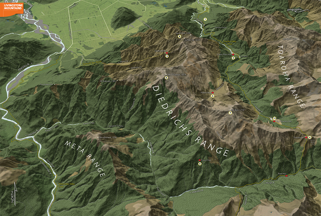
Toaroha and Hokitika rivers, West Coast
A compact, rugged tract of mountain country, the Diedrichs Range stands between the deep canyon of the Toaroha Valley and the West Coast plain and the mighty Hokitika catchment to the south.
The range offers difficult terrain, with huge height gains from valley floor to ridge crest, and is beset by sub-tropical rain forest and regular deluges from off the Tasman Sea.
There are several good valley tracks around the foot of the range and several high tracks that penetrate the upper basins and ridge crests above the bushline, making round trips achievable in good conditions. Several excellent huts are also scattered along the range.
1 Toaroha River
This is the major catchment along the range’s eastern flank. It has a good track running the full length of the valley all the way to Toaroha Saddle and its route to the Hokitika catchment.
2 Cedar Flats Hut
A large new hut that makes an excellent introductory point for the range and environs. There are also some good hot pools sited near here and a spectacular rock-walled gorge in the main valley just above the hut.
3 Gerhardt Spur Bivouac
From the west, a long tortuous track climbs Gerhardt Spur to a small bivvy and from there the range crest can be reached and Jumble Top (1610m) climbed. A descent could be made over Squall Peak to reach the track to the mid-Toaroha.
4 Toaroha Saddle Bivouac
At the head of the Toaroha Valley and at the south-eastern end of the range is Toaroha Saddle (1161m) and its small bivvy. There is access to Diedrichs Range from here or trampers could descend the steep track to the Mungo branch of the Hokitika and Poet Hut.
5 Mullins Hut
A remote and moderately difficult hanging basin on the east side of the range contains some interesting country and the small Mullins Hut, lying on a tussock flat near the head of the valley. The range can be reached from behind the hut, but travel here is never easy. A track exists from the Toaroha to the hut, but the main river must first be crossed.
6 Frisco Hut
Secreted on the southern faces of the range above the fearsome canyons of the Hokitika Valley, Frisco Hut is seldom accessed by trampers and will need some days of difficult travel to reach via overgrown tracks. It is a great achievement for experienced parties.
7 Mt Ross
Easily reached from Toaroha Saddle, Mt Ross (1770m) is a fantastic viewpoint. Onward travel along the range is not so easy as a difficult and dangerous razorback section lies north of here, requiring a descent into the upper Darby Creek to negotiate.
8 Mt O’Connor
Mt O’Connor (1814m) is the range’s highest peak. It’s most readily accessed from Mullins Hut via the faces and spurs above it. It can also be reached from Gerhardt Bivvy.
9 Squall Peak
Squall Peak (1405m) is the last tussock summit on the range before it descends into difficult scrub and bluff country above Toaroha Canyon. A good track leads to this summit from Cedar Flats.
10 Top Toaroha Hut
A park-like basin in the upper Toaroha contains Top Toaroha Hut, nestled beside the valley track heading to Toaroha Saddle. The hut has a remote and beautiful setting.