A magnificent horn of a mountain, carved from the competing attentions of several glaciers, Mt Hooker is an arresting peak that forms the centrepiece of the expansive Hooker-Landsborough Wilderness Area.
It was (re-)named in 1863 by explorer Julius Haast after the esteemed British botanist, Joseph Dalton Hooker.
Early last century, the mountain was a coveted prize. Mountaineer Samuel Turner tried to climb Mt Hooker every year for 12 years, before he was finally successful with the first ascent in 1928.
In Turner’s day, access was long and difficult, and his success was partly thanks to securing enough packhorses to gain access up the area’s notoriously large and difficult rivers. In some respects, not much has changed. Completion of the highway between Wanaka and Fox through Haast Pass in the mid-1960s provided road access to the fringes of the area, but the core has remained largely without huts and tracks.
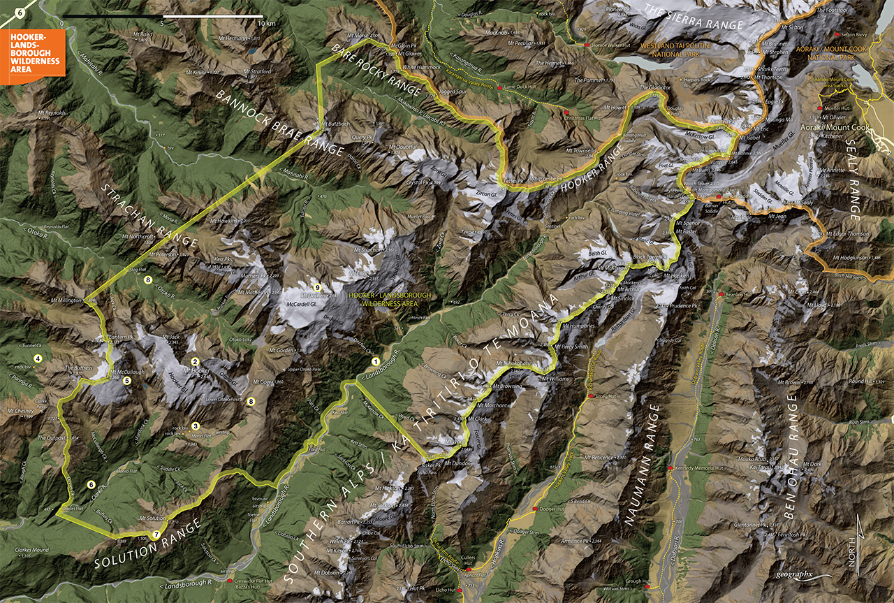
After a sustained campaign by Federated Mountain Clubs, the area was finally gazetted as a Wilderness Area in 1990. The 41,000ha wilderness spans much of the length of the Landsborough, plus the headwaters of the Makawhio, Mahitahi, Otoko, Paringa and Clarke Rivers. Its centre is Mt Hooker and the Hooker Range, which – curiously – are higher than many of the peaks immediately adjacent on the Main Divide.
Geologists explain this anomaly by surmising that the Hooker Range was, until three million years ago, the Main Divide with the Landsborough River then situated on the east. Gradually, as the Main Divide shifted east, the Landsborough was captured into the Haast catchment. This left the Hooker Range as a western outlier.
1. Landsborough River
The Landsborough has an almost mythological status among trampers, as it runs for 60km hard against the Southern Alps, before bending west to join the Haast River. The lower Landsborough is easily accessible on a track beginning from SH6 at Pleasant Flat.
Strutt Bluff and Harper Bluff were traditionally formidable obstacles to trampers, but have been made easier with marked routes. Above Toetoe Flat, there are no tracks or huts, but the true left of the river does provide relatively good – if bouldery – travel.
It’s no river to mess with in flood and even when in normal flow can be impossible to ford. Access into the headwaters is possible from tracks in the Karangarua Valley, over Mt Howitt, Gladiator Peak and the Maori Glacier.
2. Mt Hooker
Mt Hooker (2640m) is a fine pyramid of glistening ice dominating the centre of the wilderness area. While not a highly technical peak, the long and difficult access means it’s not often climbed. Most parties tackle it from Marks Flat, up the Hooker Glacier.
3. Marks Flat and Rock Bivouac
Marks Flat is a curiously large flat set in the centre of otherwise precipitous terrain, with the towering southern face of Mt Hooker looming above it. In the 1960s venison-recovery days, there was an airstrip on Marks Flat, but now access is by foot only. Two rock bivs exist on the flat’s western side: one large enough to pitch a tent or three beneath it.
4. Tunnel Creek Rock Bivouac
One of the main routes to Marks Flat is up the Paringa River, past the recently renovated Tunnel Creek Hut, then up a route to a good rock bivouac at the bushline west of The Buttress. Commonly called the Tunnel Creek Rock Bivouac, it’s sheltered in the worst weather.
5. McCullaugh Pass, Mt McCullaugh
From Tunnel Creek Rock Bivouac, a route sidles across tussock ledges to a saddle at the head of McCullaugh Creek, which provides access to the Clarke headwaters and, by way of Saddle Creek, to Marks Flat. Though the pass is not named on maps, most trampers know it as McCullaugh Pass. While mostly straightforward, it does have a steep eroded section that can be tricky to get past.
6. Clarke River
The Clarke, a major tributary of the Landsborough, drains Marks Flat, and offers an alternative approach into the wilderness. Travel upriver is relatively straightforward when the river is not in flood (crossing the Landsborough first often presents problems). Trampers can be ferried up the Clarke by jet boat to below the first gorge, before the wilderness boundary.
7. Solution Range
The Solution Range is pretty close to tramping paradise – once you reach the tops. Access is from either the lower Landsborough, or from the Clarke. A long climb through beech forest leads to the undulating tops, which are pleasantly tarn-strewn in places. The range offers outstanding views of Mt Hooker.
8. Otoko River and Lower Otoko Pass
The Otoko River, a tributary of the Paringa, offers tough access to Marks Flat from the north. Largely untracked, and with tight forest and big boulders to negotiate, the Otoko is not for the faint-hearted, but trampers reaching its head are rewarded by a spectacular view of the decaying ice-fields of the McCardell Glacier beneath Mt Dechen. From the valley head, a fairly arduous route crosses Lower Otoko Pass, where a sidle along the Solution Range is often necessary to avoid waterfalls blocking direct access to Marks Flat.
9. Mt Dechen
Viewed from the Landsborough, Mt Dechen (2643m) is a giant, pudding-shaped dome, with glaciers dribbling down its slopes. Access is long and difficult, and routes through the glaciers can be complicated or cut off entirely.
From Tunnel Creek Rock Bivouac, a route sidles across tussock ledges to a saddle at the head of McCullaugh Creek, which provides access to the Clarke headwaters and, by way of Saddle Creek, to Marks Flat. Though the pass is not named on maps, most trampers know it as McCullaugh Pass. While mostly straightforward, it does have a steep eroded section that can be tricky to get past.