Arthur’s Pass National Park
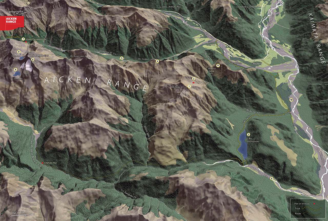
Lying in the heart of Arthur’s Pass National Park, the Aicken Range runs due north from its intersection with the Main Divide near Goat Pass to fan out into two large sub ridges protruding eastwards into the Otehake catchment. One of these is dominated by the popular Mt Pfeifer, while the other runs east from Mt Russel and has no named summits but several moderately high peaks.
Wholly contained within Westland, the range is rough country with not a single marked track to boast of yet a huge array of opportunities for those seeking wilderness and adventure. Much of the activity centres around the northern end of the range at Pfeifer Bivvy, where there are some unmarked routes onto the tops. Other than this, the tops require careful planning to reach and traverse.
1 Mt Pfeifer
At the north eastern end of the range Mt Pfeifer, 1704m, is unmatched for its view over both the Otehake and Taramakau catchments. It is readily climbed from Pfeifer Bivvy and can be included in a traverse of this end of the range to reach the eastern end of Lake Kaurapataka.
2 Pfeifer Bivouac
There has been a bivvy on this site for decades, but the latest structure now occupying the large northward-facing basin has none of the charm of the previous biv. Still, it is welcome just the same as a retreat for those seeking a remote location that can only be reached with some effort and in good conditions.
3 Lake Kaurapataka
Large, bush-enclosed Lake Kaurapataka hides in the folded landscape below Pfeifer Bivvy and is a popular weekend tramp. There is a track along the southern shore via Pfeifer Creek and the lower Otehake River flats. There are some limited campsites at the lake shore.
4 Mt Tarapuhi
South of Mt Pfeifer is Mt Tarapuhi, 1605m, a rugged little summit requiring some daring to reach as it is beset on both sides by crumbling razorback ridges. There are some wonderful alpine basins along this route, particularly on the south-west side of Mt Pfeifer.
5 Deception River
A large catchment flanking the eastern side of the range, the Deception River is a well-used tramper’s route to Goat Pass on the Main Divide and as such offers some alternative ways onto the range, especially up Good Luck Creek (bad waterfall) and the Upper Deception.
6 Otehake River
The Otehake is a designated Wilderness Area, but still has an old track running through it and a hut – Otehake Hut. The travel here is rough and slow and requires good judgement.
7 Upper Deception Hut
Set near the limit of the bush in the Deception River, Upper Deception Hut has a remote feel to it and stands just above this flood-prone river. It is a good stopover point if you are heading over Goat Pass.
8 Mt Franklin
The highest peak on the range, Mt Franklin, 2145m, is a moderately difficult climb and has a reputation as a climber’s mountain. It is a remote peak for Arthur’s Pass National Park and is usually accessed via Good Luck Creek or the ridgeline from Upper Deception.
9 Lake Sally and Anna
These two large alpine lakes are set in high cirques to the south of Mt Franklin. They are both at around 1700m elevation and command spectacular views.
10 Taramakau River
Immediately north of the Aicken Range runs the Taramakau River, a major Westland river system carrying a large volume of water. Apart from the Deception, it is the most regularly used access to the range and the Otehake.
11 One Shot Hill and Waharoa Saddle
Waharoa Saddle is reached on the lightly marked route to Pfeifer Biv. By crossing the Morrison Footbridge at the confluence of the Otira and Deception rivers and heading up Paratu Stream to the saddle, the ridge south of here can be followed around to the high basins. One Shot Hill is readily climbed from the saddle on a scrubby route.