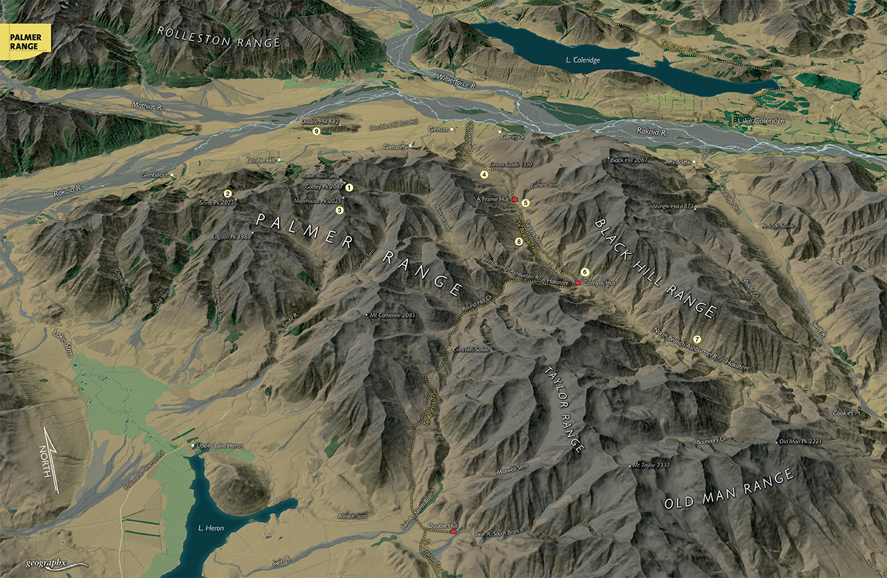
Running alongside and south of the upper Rakaia River in central Canterbury, the Palmer Range forms part of Hakatere Conservation Park and a barrier range between the Rakaia watershed and the Lake Heron Basin.
Its moderately high, bare ranges are seldom-visited but offer excellent high climbs for trampers and hunters at any time of year and incredible panoramas of the Main Divide peaks of both the Mathias and Rakaia rivers. At its eastern end, the range also forms part of the route for the Te Araroa Trail.
The interior parts of the range are remote and have moderately difficult access.
1. Godley Peak and Mother Millers Springs
The highest summit on the range at 2087m, Godley Peak is a long climb of more than 1400m from the Rakaia Valley. Though not difficult, the route climbs over several kilometres of ridgeline and sub-peaks. The summit is also to be noted for the presence, in some seasons, of a remarkable cold spring, Mother Millers Spring at 2020m.
2. Smite Peak
Smite Peak, 2025m, lies west of Godley Peak on the crest of the range overlooking the Lake Heron Basin. It is a long climb and because it is not in Hakatere Conservation Park, permission will be required to climb it from Glenfalloch Station.
3. Moorehouse Peak
Just 1km south-west of Godley Peak is Moorehouse Peak, 2025m, an outlier of the Palmer Range. It can be climbed by traversing the range crest to the summit for a view into the Smite River and Lake Heron Basin.
4. Turtons Saddle
Probably the range’s most visited point, Turtons Saddle, 1130m, is a broad tussock saddle at the head of Glenrock Stream and is the crossing point for the Te Araroa Trail from the Rakaia to Lake Heron. It is a wonderful place to go and experience the Canterbury high country as well as an access point for the eastern end of the Palmer Range.
5. A Frame Hut
Also part of the Te Araroa Trail, A Frame Hut is nicely sited on the south side of Turtons Saddle beside Comyns Stream and has a fine view of the range and upper Turtons Stream. Black Hill can also be climbed from here.
6. Comyns Hut
Further down Turtons Stream is the eight-bunk Comyns Hut and its adjacent predecessor, now derelict. Comyns has a truly remote ambiance which is enhanced by the scale of the Black Hill Range to the east where the summits rise to above 2000m. It is an excellent overnight trip into the region or as part of a longer trek through the range.
7. North Branch Ashburton River
Beyond Comyns Hut, Turtons Stream becomes the north branch of the Ashburton River and as such can be followed through its gorge in low flows all the way to Cookies Point in the Swift River, thereby linking it with Redcliffe Saddle and easement back to the Rakaia River.
8. Te Araroa Trail
The Te Araroa Trail passes through the range, over Turtons Saddle, down Turtons Stream to Comyns Hut and then up Round Hill Stream and over Clent Hills Saddle, 1485m, and down the Swin River North Branch to the Lake Heron Basin at Double Hut.
9. Double Hill
Though not actually on the range, Double Hill is a large roche mountee (a rock formation created by the passing of a glacier) standing in the midst of the Rakaia Valley beneath the range. It has two marked and poled covenanted public land areas on its flanks covering parts of the two summits which command fantastic 360-degree views over the Rakaia Basin.

34 years of inspiring New Zealanders to explore the outdoors. Don’t miss out — subscribe today.

Questions? Contact us


