
With easy access to peaks and roadside tracks, Arthur’s Pass National Park is a magnet for outdoor enthusiasts.
The park’s diversity is its overriding attraction. With striking transformations from one environment to the next over short distances, there is a plethora of weekend or multi-day excursions to cover all the bases. In the west, the park shoulders up against the Main Divide with numerous glaciated summits up to 2400m, where high passes and cols provide access to the western side of the Southern Alps. In the north, the road continues over Arthur’s Pass to Westland and the wild and rugged ranges of the West Coast. Eastwards is a remarkable region of large, seldom-visited watersheds, beautiful beech forest and kilometres of navigable ridgetops, while in the central section the road heads down to Canterbury, revealing a region of tracked and hutted valleys which form the bread-and-butter trips of many a tramping party.
With Christchurch less than two hours away, day trips are a common feature, especially from the highway where many tracks head into the valleys and up the ridges to the open tops. Arthur’s Pass is preeminently the ‘people’s park’ where the landscape, albeit big and bold, is accessible in one way or another to all.
Let’s then consider what some of these possibilities might look like if you were to take a week and travel the road north and west into the park and this mountain playground.
Visit the Devils Punchbowl
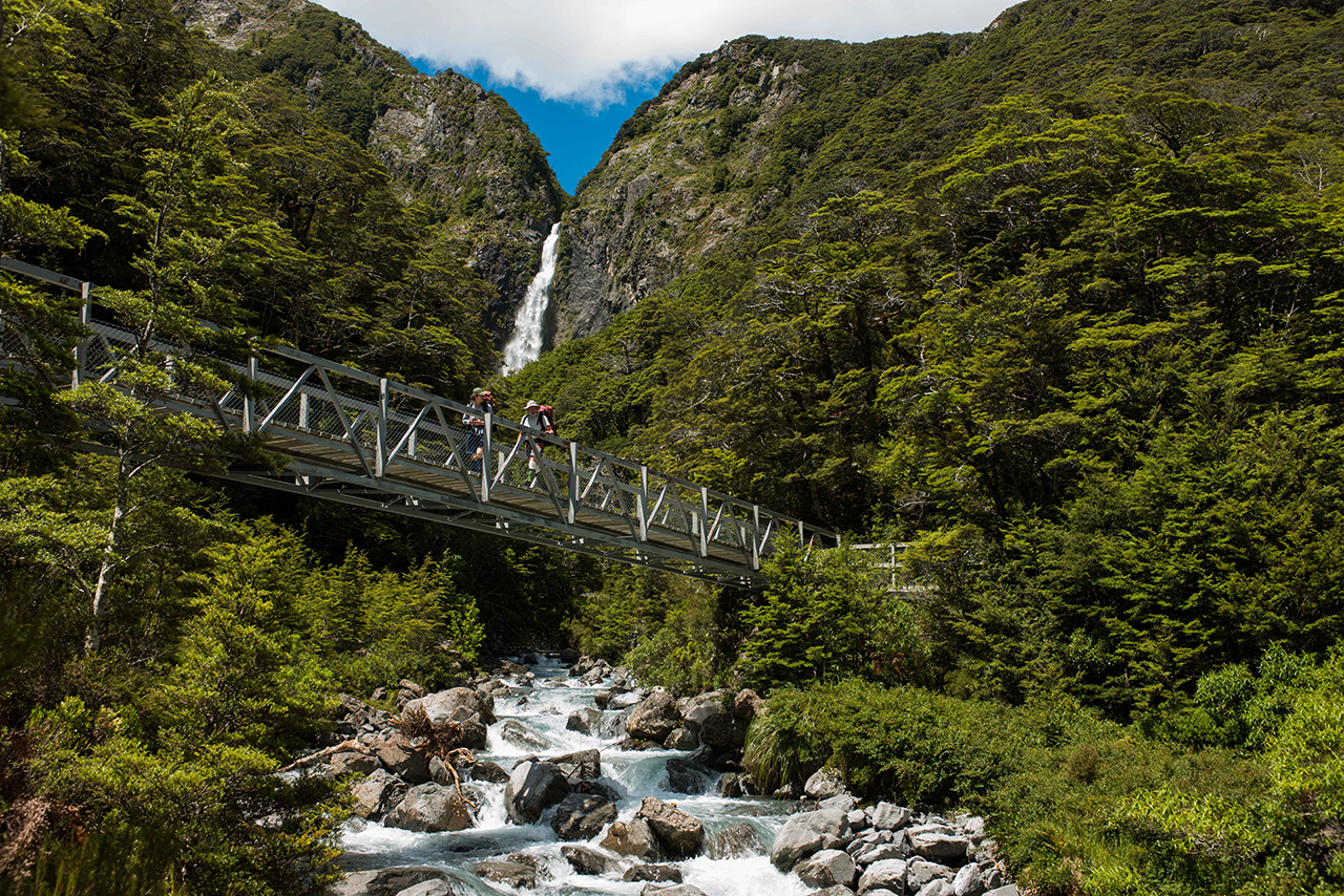
One of the park’s most accessible and loved features are its waterfalls, and none more so than the stunning 112m drop of the Devil’s Punchbowl Falls, just north of the village.
The falls are a drawcard for almost every visitor to Arthur’s Pass, and these days are reached along a high-grade tourist track complete with steel stairs, gantries, and a viewing platform set amid the forest canopy and just below the fall’s spray line.
The walk through the forest and to the amphitheatre containing the falls is particularly scenic with great views of the surrounding mountains and landforms.
The falls are powerful, mesmerising, and a grand spectacle where they drop from the cliff edge into a shallow pool at the base. This can be reached with care by the agile; however warning signs dissuade visitors from going too close.
Cross an alpine pass to Westland

The long north-western border of Arthur’s Pass National Park provides numerous opportunities to trek from east to west or vice versa over the Main Divide.
Most of these journeys will involve a three- or four-day trip through a complexity of terrain and vegetation, crossing a 1100-1800m alpine pass and a descent, if going east-west, through subtropical rainforest into the surreal beauty of Westland.
Nearly all the routes have marked tracks to and from the bushline, some have poled routes over the passes themselves. Most have excellent valley huts sited within a few hours of the pass summit, with further huts downstream so you can spread the days going from hut to hut. Some of these huts can be small, so a tent is advisable, as is at least an ice axe for the higher routes, and good river crossing skills.
The best of these routes are Waimakariri Col, Harman Pass to the Taipo, Taruahuna Pass to Tarn Col and onto Walker Pass and Minchin Pass (a long route).
Climb a peak from the road
Arthur’s Pass Village is renowned for the number of well-marked tracks that leave the highway and head skywards at a rapid rate of ascent to reach the bushline and open tussock shoulders on the peaks above.
Beyond this vantage – depending on the weather, your experience and the conditions – there are some great options to go higher.
Some of the best choices are Avalanche Peak, Mt Bealey, Mt Aicken, Mt Cassidy and Mt Barron. Snow can still be present on these summits until well into the summer and can return again in autumn, yet the views gained and experience of high-ridge travel is quite extraordinary.
Some of these summits can be linked via a high traverse with a descent down another peak’s access track. Take care; these ‘walks in the park’ are no push-over.
Find a family-friendly hut

The Hawdon Valley is one of the more accessible and user-friendly valleys in the park and its hut can be reached in a 2-3hr walk, mostly along the riverbed.
Hawdon Hut commands an excellent view of the headwaters and receives a good deal of sunshine, even in the winter months. It sleeps 20 with ease, has a good log burner and large common area with cooking benches. There’s a north-facing deck and easy access to the river, as well as the onward track to Walker Pass.
The hut makes an excellent destination for families or those just wanting an easy overnight option and somewhere nice to relax for a day or two.
Traverse the Coast-to-Coast mountain run
A great introduction to tramping in the region is to follow the route of the Coast-to-Coast mountain run through the Mingha-Deception valleys and over Goat Pass. This could be done either as a day tramp – at a run – or as an overnighter by staying at the nicely sited, but cold, Goat Pass Hut.
The trip involves a lot of river travel and unbridged crossings of both the Deception and Mingha, which can be difficult, particularly during and after heavy rain. Plan accordingly and make sure you have a two-day weather window for the trip.
Earn your turns at a club ski field

Only one national park in the South Island can boast having a ski field within its boundaries.
Temple Basin is located above the highway and with walk-in access only, it takes about 90 minutes to reach the base lodges.
You can either day-ski here or overnight – pre-booking is essential – at one of the large lodges. The skiing is generally steep and moderately demanding, set amidst the spine of the Southern Alps where dramatic scenery awaits at every turn.
During summer, a climb to the lodges will reveal more alpine flowers, great views and hidden tarns high up among the peaks. It is also possible to spend a full day traversing the ridge crest south from the ski field back to the village, via the summit of Mt Cassidy.
Botanise amongst alpine flowers
New Zealand’s alpine flowers are well-known for their diversity and spectacular blooms in very beautiful locations, especially the much-loved and photographed Mount Cook lily.
This lily is really a buttercup, but don’t let that deter you from a quest to find it – after all, the park is one of the prime spots for locating and photographing these alpine flowers.
An easy access track from the highway leads to the upper Otira Valley, climbing a moderate gradient and on the way passing through several small, sheltered, north-facing gullies which are ideal habitat for Mount Cook lily, flowering here in late spring to early summer. The location can be reached in less than an hour from the highway.
Throughout summer, other species of alpine flowers can be found farther up valley.
Spend a night in a tiny hut on the tops

There’s no marked track to Pfeifer Bivvy, a tiny hut set on an open tussock bench high above the Taramakau Valley. It is very remote, and moderately difficult to reach. Good weather, sound judgement and strong navigational skills in open rocky terrain will be required.
The rewards gained are commensurate with the difficulties involved: the setting, amid the peaks, and the views and ambiance, are unmatched.
The normal route climbs Paratu Stream from the Deception River to Waharoa Saddle and then south and east from there along the ridge and through basins to reach the hut. Only two bunks are available so make sure you have a tent and a cooker.
Nearby Pfeifer Peak, 1704m, can also be climbed via a short scramble from the hut.
An overnighter to a hidden waterfall
If waterfalls really whet your appetite for discovery, then you can try the hidden spectacle of Twin Falls in the upper Hawdon Valley. This is more than a short walk and will probably involve staying the night at Hawdon Hut before clambering up the track towards Walker Pass and some careful exploration, off-track, to gain the floor of the deep canyon through which the falls flow.
Some relatively easy animal trails descend into Twin Fall Stream which can then be followed either up or down to one or both of the falls.
Be cautious here, and unless you are competent at off-track routes, it may be best to stay high and just view the falls from above.
The two falls are quite separate, and each possesses its own special character with the surrounding landscape providing an additional focus and reward for the trip.


