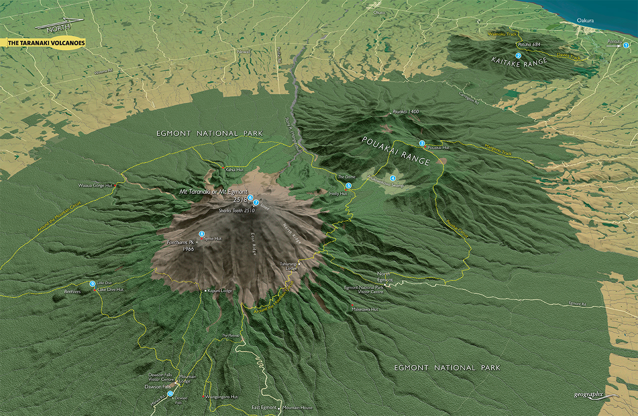
The almost perfect cone of Mt Taranaki dominates the Taranaki Bight, a seemingly permanent feature of the landscape.
But it’s only the latest in a line of four volcanoes that have welled up from subterranean depths in the region. The first volcano emerged about two million years ago, but subsequent weathering and erosion has reduced it to just stumps: now known as the Nga Motu/Sugar Loaf Islands and Paritutu. The Kaitake volcano emerged next, about half a million years ago, and has since eroded to a series of bush-clad hills. Then came Pouakai volcano, which was active approximately 250,000 years ago before weathering and erosion again took their toll.
Although no longer with the classical cone shape of Taranaki, the Pouakai Range is high enough (over 1400m) to provide interesting terrain for trampers on the Pouakai Circuit.
Trampers with a hankering for a longer trip tackle the 4-5 day Around the Mountain Circuit. As its name implies, it completely circumnavigates Mt Taranaki, sometimes on its forested flanks, at other times emerging onto its exposed, upper slopes. Although not difficult, the circuit involves reasonably strenuous tramping but takes in all the diversity of Egmont National Park, including waterfalls, goblin forest and spectacular lava bluffs.
1 Paritutu
This volcanic remnant forms a distinctive landmark overlooking the port of New Plymouth. A steep track leads to the summit (154m), which has good views over the city, the Tasman Sea, and the Nga Motu/Sugar Loaf Islands.
2 Kaitake Range
This old volcano has whittled down to a lumpy range barely topping 680m. The Davies and Waimoku tracks lead to the summit, which is called Patuha. Both take about 4-5hr return.
3 Pouakai Hut
Pouakai Hut is the only hut on the Pouakai Range since the old Kaiauai Hut was replaced by a shelter some years ago. The 16-bunk hut sits just below the crest of the range and offers an excellent northern view overlooking New Plymouth and the surrounding Taranaki farmland. An uphill stroll leads to a superb vantage point to the south, where Mt Taranaki dominates the Ahukawakawa Swamp. Reached as part of the Pouakai Circuit, or from the Mangorei Track.
4 Ahukawakawa Swamp
The Ahukawakawa Swamp was formed about 3500 years ago when a debris slide blocked the course of the Stony River. Flax, red tussock, sedges and small-leaved shrubs dominate the swamp vegetation, which also boasts several endemic plants. The Pouakai Circuit crosses the wetland on an extensive series of boardwalks.
5 Holly Hut
The 32-bunk Holly Hut is the largest public hut in Egmont National Park and has good views of the Pouakai Range. It serves as accommodation for trampers tackling the Pouakai Circuit, or the Around-the-Mountain Circuit.
6 Mt Taranaki
At 2518m, Taranaki is the second-highest volcano in New Zealand and the most isolated summit in New Zealand. While a straightforward scramble from the north in summer conditions, the mountain should never be tackled lightly and requires sound skills and appropriate equipment no matter what the season.
7 The Shark’s Tooth
The East Ridge of Mt Taranaki rears up impressively to its apex on the Sharks Tooth (2510), one of the more spectacular features of Mt Taranaki’s
8 Syme Hut
Arguably the most spectacularly-located hut in the North Island, Syme Hut sits perched atop Fanthams Peak, with sensational views of the Tongariro volcanoes, the Tasman Sea and the great forested hinterland surrounding the Whanganui River. It’s named after Rod Syme, founder of the Mt Egmont Alpine Club, Federated Mountain Club’s stalwart and outdoorsman extraordinaire. Syme was instrumental in building the original Syme Hut, which was replaced by this DOC-built, 10-bunk version in.
9 Lake Dive
The only sizeable body of water in the national park, Lake Dive formed behind rounded knobs known as the Beehives. Two tracks lead to the lake and nearby Lake Dive Hut (16 bunks) from Dawson Falls; the lower and upper tracks. Both take about 4hr.
10 Dawson Falls
Dawson Falls (16m) is one of several impressive waterfalls in the park. A viewing platform overlooking the falls is reached on a 10min track leading from a car park near Dawson Falls Visitor Centre. Another 10min walk down a series of stairs leads to the base of the falls.