
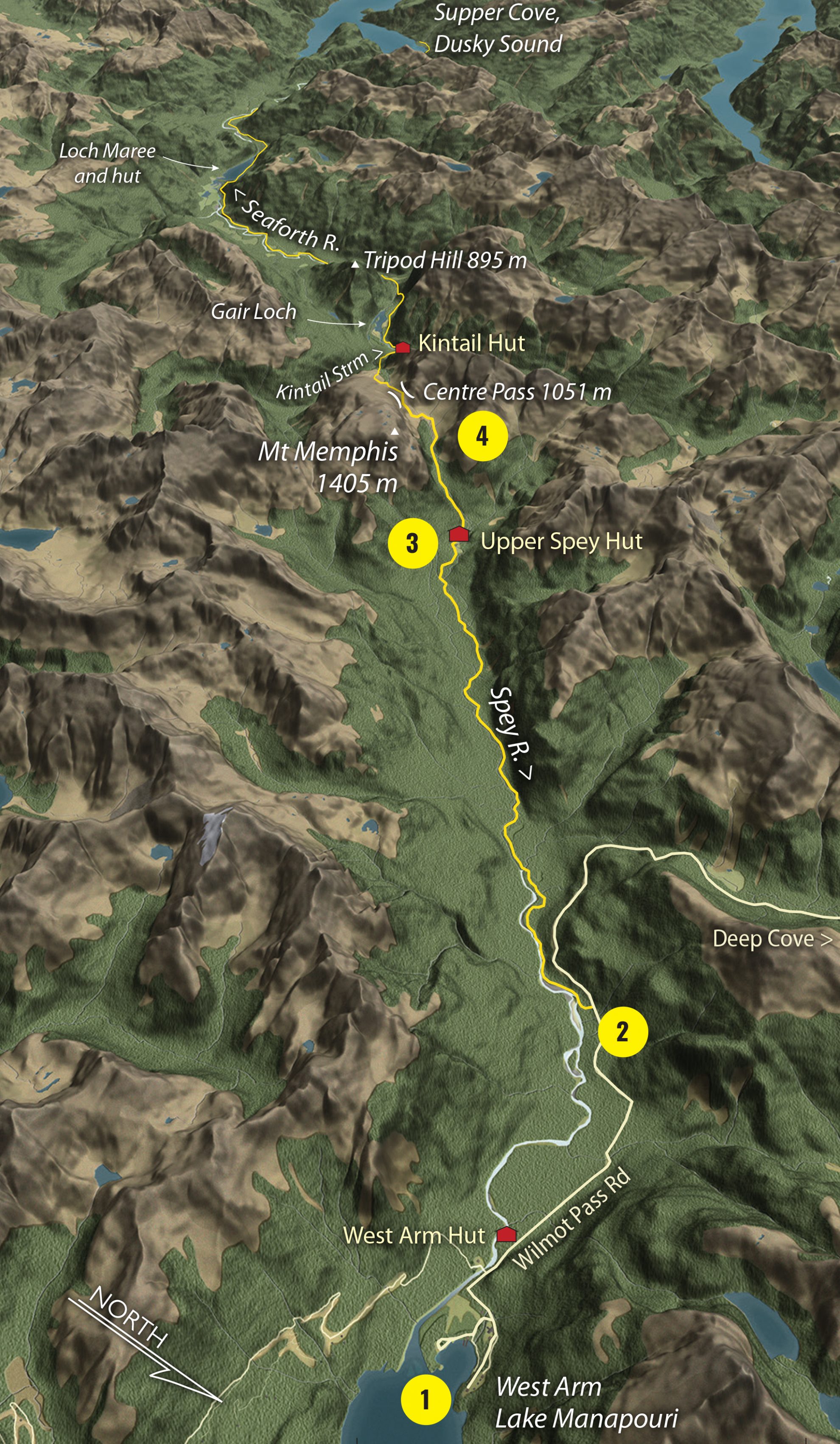
1 West Arm
The Dusky adventure begins with a one-hour boat journey down the Waiau River and across Lake Manapouri to West Arm. New Zealand’s biggest hydro-electric power station is here, constructed during the 1960s and completed in 1971. The dam was supposed to raise Lake Manapouri by 30m, but a massive environmental campaign prevented this from happening.
2 Wilmot Pass Road
Board the bus for Deep Cove – but after 10 minutes, get the driver to drop you at the trackhead.
Disappear into ribbonwood and dense beech. The mid-reaches of the Spey River is easy going until the first bog is reached and gaiters are baptised in knee-deep mud.
3 Upper Spey Hut
Boardwalks betray the location of Upper Spey Hut, where a black cloud of sandflies enshrouds the cabin. Dive inside, and keep the door shut. Beyond, the track abruptly hits the valley wall and climbs mercilessly upward. A sixty-degree rock step requires careful footwork to ascend. Top out in a hanging valley, a subalpine world of tussock and wild flowers. Look out for kea.
4 Centre Pass
The track meanders up and over Centre Pass where an hour’s detour to Mt Memphis (1405m) provides a higher viewpoint. To the south, the distant outline of Gair Loch is revealed, with the impossibly-angled pyramid of Tripod Hill towering above. The trail then cuts a silver thread through a tussock basin, skirting a smattering of tiny tarns. Below the bushline, a 3m drop needs some nerve to negotiate. Beyond this, the terrain is rooted and rough. At the bottom of the hill, a couple of cliffs require an abseil down using long lengths of fixed chain.
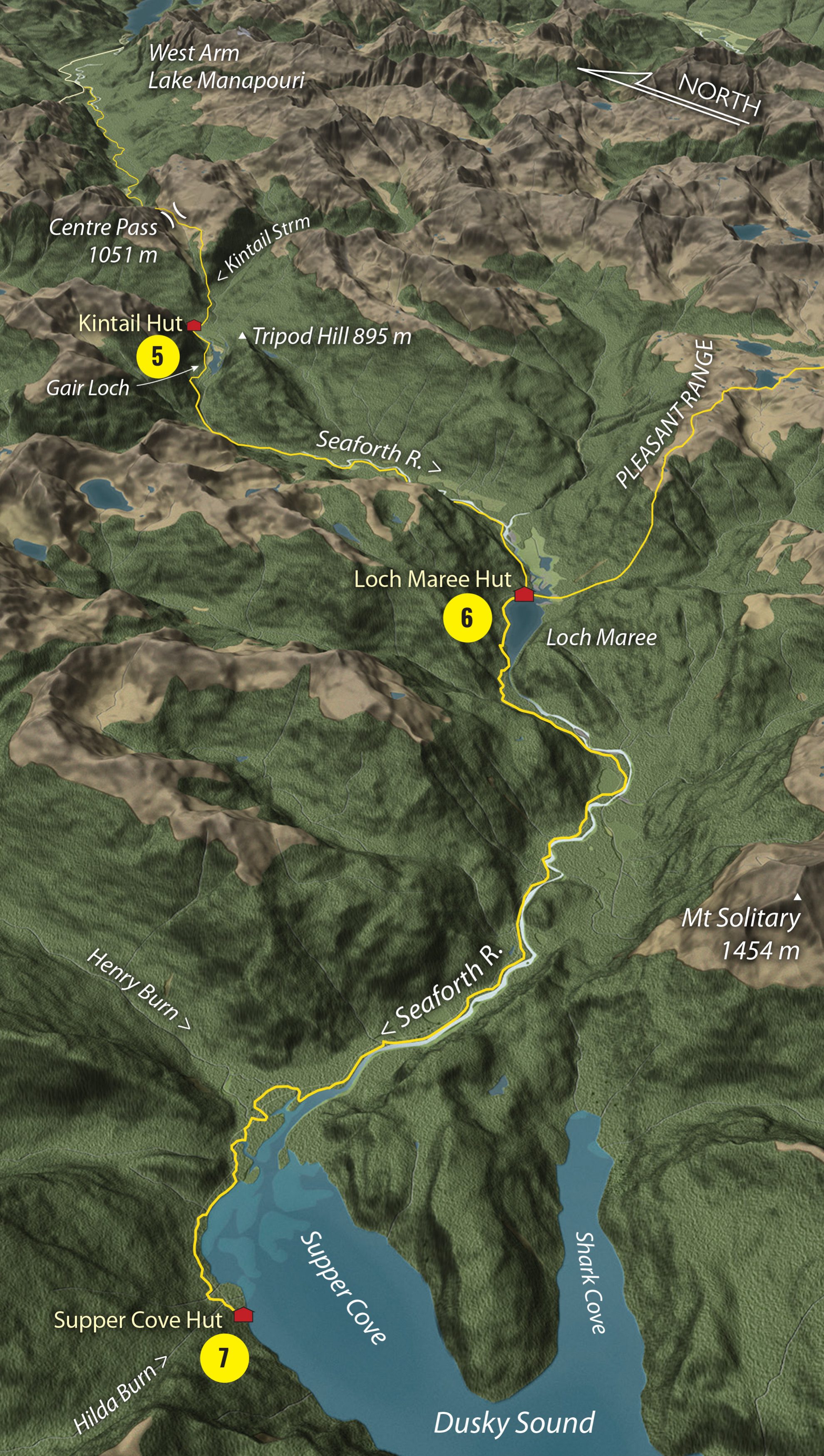
5 Kintail Hut
The trail skirts Kintail Stream to a pair of walk-wires which lead to Kintail Hut. Across scrubby river flats, past the restful reaches of Gair Loch, a handrail chain above the river aids in negotiating a tricky section of track. As the valley widens, the Seaforth River slows to a snail’s pace, merging into Loch Maree where rotting stumps of a drowned forest punctuate the moody waters.
6 Loch Maree Hut
This 12-bunker is the bottleneck where parties from three directions meet. If the Seaforth River is in flood then your escape route is cut off. Plan on spending a few days hut-bound here. An optional detour leads to Supper Cove.
7 Supper Cove Hut
Allow two days to get to the remote reaches of the fiord and back along a miner’s trail first cut in 1903. The trail spits you out at the north-east corner of Dusky Sound, named by Captain James Cook in 1770 and explored on his second voyage in 1773. To reach the hut, you must scramble through moss-covered windfall on a torturous flood track. A final bridge over the Hilda Burn leads to a boatshed, then Supper Cove Hut. Try your hand at fishing for groper and blue cod.
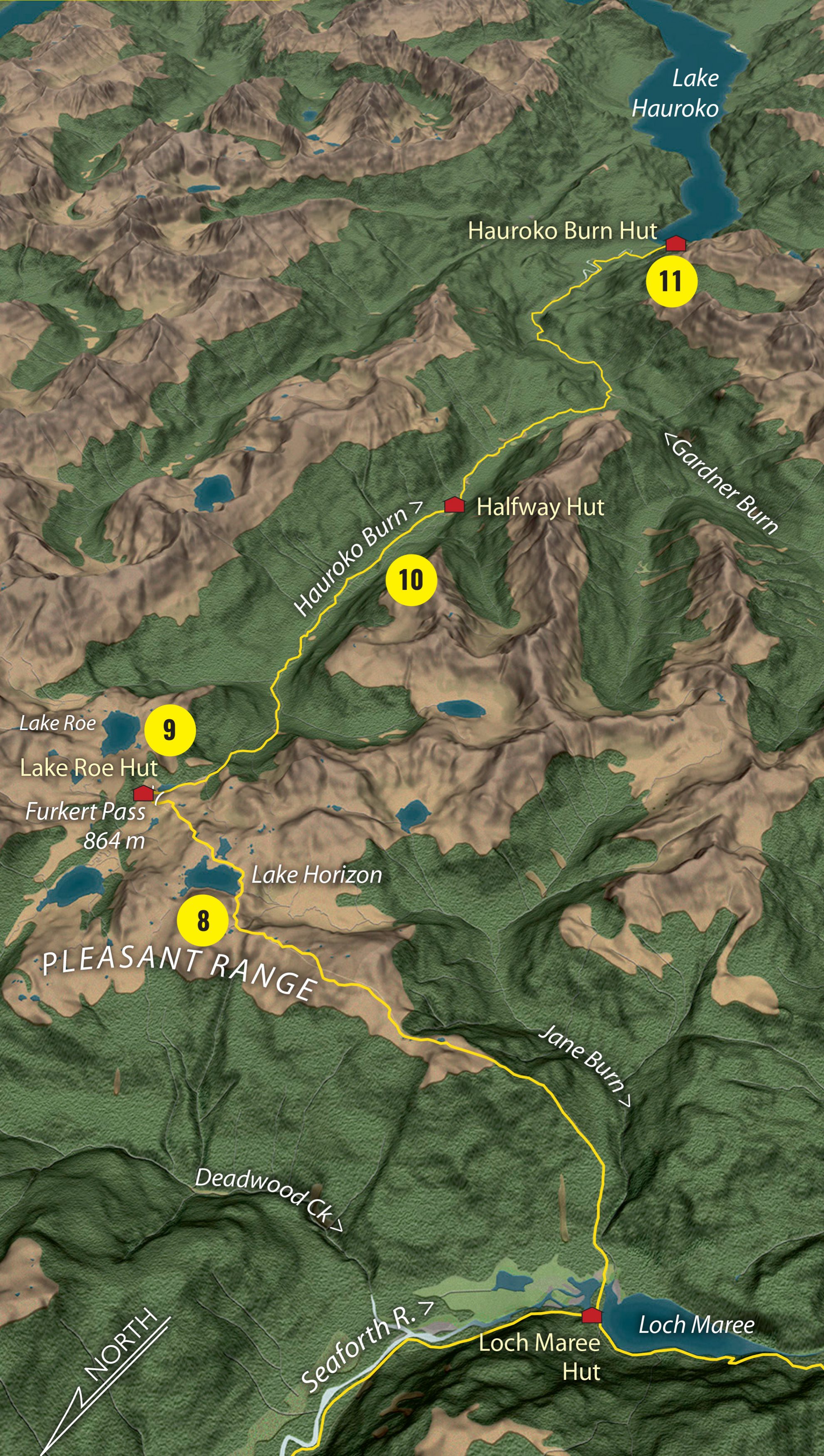
8 Pleasant Range
From Loch Maree, the track climbs through stunted forest to the Pleasant Range where there’s a grandstand view out to the Tasman Sea. Ahead, the path twists through the tussock, following snow-poles, climbing over the knobs and unnamed peaks of the range and passing the super-tarn Lake Horizon.
9 Lake Roe Hut
In clear weather, spend a day here exploring this sublime subalpine world. Half an hour above the hut is the superb Lake Roe. Listen carefully for the tiny rock wren, hopping around the place.
10 Hauroko Burn
The Hauroko Burn is the easiest section of the Dusky. There are still boggy bits and more walk-wires, but the worst is over. There’s a gentle gradient to Halfway Hut. The final leg is delightful, parallel to the river – a spent force seeping into the lake. Cross the last walk-wire and wade through a forest of crown ferns and horopito to the shoreline. If you’re brave (or very smelly) bathe in the country’s deepest lake – a tropical six degrees.
11 Hauroko Burn Hut
While awaiting the scheduled boat ride on the Namu, this lakeside hut is a suitable place to contemplate the highlights of your journey: the voracious namu; the boot-sucking bog; the scary walk-wires; the incessant rain; the tired old huts – you will have epic memories.


