
Squeezing the trigger, I gently extend my reach so that I’m standing on tip toes – shoes smearing on the coarse granite – and jam the cam into a matchbox-sized gap in the overlap. Abeit marginal, it’s nice to have a piece nearby, but it’s just another in a string of less-than-textbook gear placements that stretches back to John and Alan waiting at the belay, hidden from sight on Karetai Peak.
The bad protection behind me is eating at my resolve. I’m convinced that if I fall, some of the gear will rip, causing a long fall and probable injury. A remote wall in the Central Darrans is no place for an accident. Two voices are making are tugging at my mind. One says to go for it, the other says be conservative. My options are few: I doubt I can back-climb the moves I made to get here and a roof to my right will bar further traversing.
I shut my eyes, and search for some quiet to quell my rising fear, then try and make the sequence work one more time.
We’d helicoptered in, on the tail of a southerly, from Milford to a site above Turners Biv. After the helicopter left, the four of us sat silently on the windswept snow.
It was day one of a week-long trip and we were headed for Turner’s Eyrie; an unlikely bivouac location etched into a cliff at 2000m on Karetai Peak. The bivouac was discovered by Richard Turner in 2004 and first utilised by Turner, Richard Thomson and Dave Vass in 2006 as a climbing base.
Eager to get over to Lake Turner, below the Eyrie, we traversed snowfields and padded up glacier-worn whalebacks of rock towards the col that separates Mt Milne from Tarewai Peak. To get into the cirque of peaks that rings Lake Turner, Tarewai itself has to be traversed via its north and south ridges. At the col we peer into the colossal defile that drops hundreds of metres into the Cleft Creek side of the range. Distant, we can see the Hollyford River meandering through verdant forest. It’s a daunting and magical place.

On one side of the col, Milne’s steep south ridge climbs into the mist, and on the other John slowly climbs up rime-plastered rock on Tarewai. He gets through the crux and runs out the rope up easier ground. Before long we’re all on our way higher, scrambling up the blocky ridge. As we summit peak one of the trip the clouds begin to break and soon we’re eating lunch and loving the views out to both sides of the range.
Far below, Lake Turner beckons and soon we’re off, carefully down-climbing to Pikipari Pass. From the pass, the route descends névé and slabs, and it’s late in the afternoon when we round the corner beneath the huge western buttress of Mt Mahere and peer into Lake Turner cirque. Far above is tomorrow night’s destination; the Eyrie. The distant twinkling lake lends some serenity to an otherwise twisted landscape. We stand speechless, watching Turner’s waters narrow and then plunge into the black abyss of Cleft Creek.
The bivy rock at Lake Turner is not much, but a custom made fly (courtesy, Richard Turner) provides enough shelter to keep the overnight rain off. It’s still drizzling after dawn, but by the time we’re ready to walk, the rain’s stopped and discussion starts as to the objective for the following day. We’re spoilt for choice – surrounded by rarely climbed peaks and unclimbed walls.
So we begin the exposed climb out of the cirque, following slabs broken by occasional ledges. We skirt beneath the north-west flank of Karetai, up ledges and bluffs, glancing sideways at glacial remnants scattered like a giant’s discarded dice.
It’s a precarious entry to the Eyrie whichever way you go: along an Indiana Jones rock ledge, or from above via an exposed scramble.
We scuttle along to the rock wall protecting the front of the bivvy, dump our packs, and set about making it home. The cache of food, stove and climbing kit is excavated and we settle down to a brew whilst taking in the panorama of peaks out the front door. Opposite, is the dominating rocky spear tip of Te Wera. Named after the great Ngapuhi chief, Te Wera was first climbed by Lindsay Stewart and David Lewis via the North Ridge in 1938. This proud first ascent being one of many Lindsay pioneered in the range during the 1930s. It’s this seldom climbed ridge that we decide on for the next day’s climb.
We leave camp by the light of our torches and retrace steps beneath Karetai. Dawn breaks as we begin the climb up iron hard névé towards a notch in the West Ridge. Beyond the notch we cruise along rock slabs and then up to a col at the base of the ridge. It’s a perfect day; no wind, clear skies and a long rock ridge ahead of us.
I get the first lead and with Tom climb two full pitches up nice slabs and corners until the ridge mellows in angle. The climbing’s eased and the exposure’s increased but we feel comfortable without the rope and scramble up the angular spine with John and Alan close behind. Near the top, the rope comes out again for a short steep pitch and soon we’re on the summit. A lot of Fiordland lies below. We pick out peaks climbed, valleys explored and trace new lines, imagining future adventures. It’s an insight into a hidden world.
The descent goes easily, with three rappels and, by mid afternoon, we’re back at the base. We’ve been out 12-hours, yet over dinner, talk turns to the following day. We’re all tempted by the steep North West flank on Karetai, only 20 minutes from the bivvy. Rich, Rich and Dave had climbed an instant classic on their first stay here, Statue Bro (19, 6 pitches) and we’ve spied a good looking line further right. The first pitch goes through a tricky-looking roof and beyond that links up slabs and corners to an exit on the North Ridge of Karetai.
Tom decides to hang out in the viewing gallery for the day and is sipping his second cup of tea while I fight my way through the first roof. John and Alan join me at the belay and I set off on pitch two; arranging fiddly protection and making devious moves from stance to stance. An impasse comes and after 45 minutes on the lead and several attempts at a hard move I’m frustrated.

From a high runner, I tension down and right a few metres and peer over the lip of a steeply overhanging corner. On a slab below is a possible belay site. Decision made. It looks unlikely but I manage to climb sideways and down on jugs and reach the stance. For John and Allan there’s no tension from above for the moves down through the roof but I talk them through it and soon we’re clustered at the belay again. The terrain above looks more likely and soon I’m off again. I find my flow, and the terrain’s a bit easier as I head straight up the wall.
For the next four hours we weave our way up the wall. The climbing has a lot of variety and keeps us thinking, but there always seems to be protection where we need it. John takes a lead high on the wall and soon we’re a pitch from the top. The last rope length is a formality, and I race up the thin slab to the ridge crest and throw in a belay.
After hours on a steep wall there’s nothing like the feeling of finally taking off your harness, easing sore feet out of shoes and letting your hair down a little. We’re excited about our new climb, and of course the view down into the Te Puoho Glacier on the eastern side of the ridge. We snack and relax and then head off up the remainder of the North Ridge to summit number three, Karetai.
At camp that night we’re joined by Richard Thomson and Dave Vass. They’ve just completed a two-day ascent of a huge wall out of the head of the Donne Valley, terminating on the ridge between Karetai and Revelation. It’s a novelty to be catching up with these guys in the middle of nowhere and we swap stories. It storms that night and rains all the following day. But we’re sheltered and spend a much needed rest day in our sleeping bags, dozing and eating.
The temperature plunges the following night as the southerly comes through and we awake to a silent chill. Thousands of tiny icicles hang from the cliffs and fresh rime ice sparkles in the dim sunlight that’s creeping in beneath the clouds.
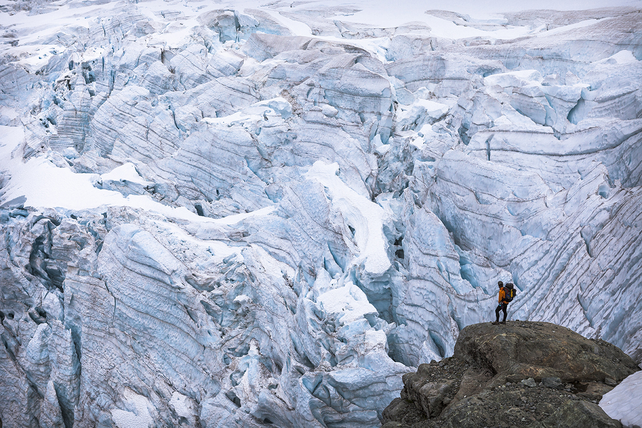
We linger for a while. It’s too cold for rock climbing, so we settle on climbing Mt Underwood in the afternoon and enjoy a scenic wander on the Taoka Icefall to summit number four, taking in an amazing view out to Mitre Peak, Milford Sound and the Tasman Sea, shimmering golden in the distance. Tomorrow we’re walking out to the Milford Highway via the Donne Valley. Though only about seven kilometres as the crow flies, it’s a seldom visited and untracked valley and will take us the full day to descend.
In 2006 Rich, Rich and Dave were the first party in decades to use the Donne Valley to reach the Central Darrans. Threatened by a receding Taoka Icefall and requiring two committing rappels as a descent, it’s not a route to take lightly. At the Eyrie, Dave and Rich describe the route, particularly the location of the two key abseils.
We leave not long after day break and after a brief search find the first of the anchors at the top of a rock buttress. We’re opposite the terminal face of the glacier, and at this point unthreatened, but it’s a dramatic location. After a short down climb we debate where to make the next rap, finally picking a spot that will land us on slabs directly under the terminal face. I’ve been studying the face intently during our descent and it seems to be locked up, but you never know when a block might peel off. We make the rap from a brick-sized horn of granite and at the bottom, while still on the rope, make a desperate jump across a creek that pours from under the glacier. The rock’s ice-caked both sides of the stream and there’s palpable tension among us as to the amount of time we’re spending exposed here. But, we all get across and pull the rope for the last time.
We flee down the slabs, glancing behind from time to time, praying that nothing will fall, and finally make it to relative safety. We’re dwarfed by the giant parabola of the upper cirque with 1200m-high faces ringing us in. Below, down-valley, fingers of water merge to become the Donne River which we’ll follow to the road. Waterfalls cascade off giant roofs way above the valley floor, the droplets drifting languidly in the breeze. We turn our backs on the towering walls and, content with the satisfaction that comes from a memorable trip, walk towards the river.


