Three great valleys, two provinces, three new conservation parks.
Canterbury’s Ahuriri and Hunter Rivers drain the eastern side of the Southern Alps; both grand, high-country valleys bounded by high mountain ranges. Forming the core of Otago’s Hawea Conservation Park, the Hunter River also originates from Main Divide glaciers.
Having the opportunity to form a relationship – an intimacy if you will – with an alpine or backcountry environment is part of the reason that keeps drawing me back to mountaineering.
Knowledge of a particular area: the lay of the land and how it is affected by certain weather conditions; how best to travel through it; and those difficult to reach spots which turn out to be absolute gems provide me with a sense of recognition, understanding and wellbeing.
One such location is the Hopkins Valley. For the past decade, I’ve spent many a long weekend exploring its mountains and side streams, its alpine meadows and rocky outcrops, its beech forests and glaciers. Some of my best climbing experiences have been with the mountains here, and I could easily spend a week doing any number of climbs.
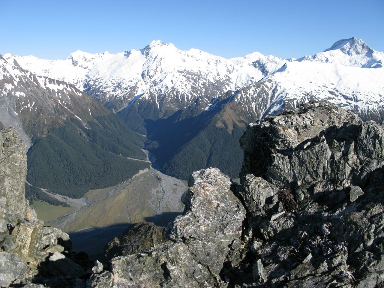
Both sweeping and expansive, the Hopkins is around 40km in length. Cattle and sheep meander along open grassy terraces near its broad entrance, and sure-footed thar whistle to each other from craggy outcrops overhead. From the road end near Huxley Lodge, a four-wheel-drive track wanders up the true right of the river to Monument Hut. From here, keen enthusiasts can bounce their vehicle further up the river flats even as far as Dodger Hut. But, unless you are in a hurry, it is much more rewarding to travel by foot.
An hour north of Monument Hut is the entrance to Huxley Valley. This is well worth the detour, spending a night at either Huxley Forks Hut or at Brodrick Hut in the north branch before returning the same way.
There are countless climbing opportunities in the Hopkins, ranging from the straightforward to the technically challenging, along with plenty of interest for tramping and exploring. The Dasler Pinnacles is one of the more popular mountains to climb, and would be at the top of my recommendations. From the floor of the Hopkins Valley, the Pinnacles appear pretty intimidating. The twin summits tower above the bush line, seemingly protected by steep rocky ridges and a west face split by a deep gash. A number of routes, both rock and ice, lead up this western aspect, yet it is the easiest route – the North Ridge – that is still possibly the best.
From the valley floor, a steep track heads up through the beech forest, reaching the rather cramped Dasler Bivouac after an hour of heavy sweating. Either spend the night at the hut or carry on up a faint track through alpine shrubbery, weaving between occasional rock outcrops, to camp right at the base of the west face. I’ve managed to find a small trickle of water each time I’ve bivvied here in the past. The North Ridge is a pleasant, if somewhat exposed, scramble on good quality rock that finishes directly at a summit with perhaps the finest viewpoint in the valley.
Just up from Dasler Pinnacles, on the other side of the Hopkins River, is the scenic and comfortable Elcho Hut and the entrance to Elcho Stream. Like the scenic Huxley Valley to the south, Elcho Stream also splits, with the northern branch leading up to Elcho Pass and Mt Ward. Elcho Pass, like Brodrick Pass, is a gateway into the wilderness area of the Landsborough Valley, while Mt Ward is one the area’s most impressive looking mountains. Every route up Ward has some technical aspect to it, but the reward is certainly worth the challenge.
A few kilometres north of Elcho Hut, Hopkins Valley narrows. Travel becomes more confined, especially after Thomson Stream – the third and final side valley branching off to the west. The best way to get further up the Hopkins is to find a route along the boulder-strewn edge of the river. In this part of the valley, the Hopkins River is less braided and more of a focussed torrent. Above Dodger Hut, sticking to the true left of the river eventually leads to Erceg Hut, which is nestled on the edge of a thick band of alpine scrub. Here, the mountains are very close and, because they are viewed from directly beneath, appear to be rather steep also.
A few hours beyond Erceg Hut, the valley ends beneath three major mountains: McKerrow, Black Tower and Hopkins itself. The easily angled Richardson Glacier curves up beneath them, tending east and finishing at Faith Col. Two days walk from the end of the road, this part of the valley is both remote and picturesque. On the other side of Faith Col, the Dobson Valley runs back down to Lake Ohau. To reach the Dobson from here, though, is more easily achieved via Tragedy Col, three kilometres to the south. Not to say that Tragedy Col is easy: reaching it from the west is straightforward, with low angled slopes leading up on to the Neumann Range, attaining a height of just over 2000m. But the descent into the Dobson is precipitous, involving steep snow and eroded bluffs. It has claimed lives in the past.
So, an ideal week in the Hopkins would involve a night at Brodrick Hut, a climb of the north ridge of the Dasler Pinnacles (high bivvy required), a night at Elcho Hut, a route on Mt Ward (two high bivvies required, or a second night at Elcho), and finally crossing Tragedy Col into the Dobson (high bivvy required). A few more days may be needed to wander back down the Dobson – oh well!

If any Canterbury valley is the epitome of what we like to think of as ‘high country’ then perhaps it is the Ahuriri.
A golden valley of tawny tussocks and patches of beech forest through which the Ahuriri River wends, and flanked by two mountain ranges – the Barrier and Huxley – that culminate in the formidable south face of Mt Huxley. Glacier-gilded, and rearing up to 2505m, Mt Huxley is the highest peak in the Ahuriri Conservation Park, which protects the upper valley and its tributaries.
My introduction to the Ahuriri came as part of an 11-day tramp in the area, which saw us cross from the Hunter over the Huxley Range into the head of the valley. The pass had proved easy enough, and we’d descended past a tarn curiously shaped like a banana, but the stream issuing from its outlet soon choked into a gorge. We’d instead been forced to sidle ledges around the brow of the spur to the south, then cut down steepish slopes until we could weave a route through bluffs into the riverbed itself.
The flat and easy going of the valley was a relief, and we’d camped down valley. There are some exquisite wetlands in the valley, like the one containing a small lake near Watson Stream, where we’d exited out to the South Temple Valley. Back then the main Ahuriri was grazed, and I’ll confess we’d sneaked through without permission.
The Ahuriri was then part of the leasehold Birchwood Station, but in 2004 purchase of the station by the Nature Heritage Fund established the nucleus of a new 49,000ha park, created in 2004. Main access to the park lies on the Birchwood Road, which branches off State Highway 8 near Omarama.
The Ahuriri Base Hut provides a good launching place for a range of adventures including tramping, mountaineering and mountain biking. Beyond Ahuriri Base Hut, the road might tax some two-wheel drives, but careful driving leads to a car park below Canyon Creek, one of the Ahuriri’s most appealing tributaries.
On my second visit to the park, we’d come up the Birchwood Road and parked well short of the car park to investigate the park’s oldest hut, tucked behind a rounded hill on the true left. The recently restored Hideaway Biv dates from perhaps as early as 1890, a rustic reminder of mustering days when the area was part of the much larger Benmore Station. From Hideaway Biv it’s possible to detour over the tops into the head of Snowy Gorge Creek, where a much newer hut (only half a century old!) occupies a fine tussock flat beneath Mt St Mary. This is grand high country: open, golden terrain that in the right weather provides non-taxing but very rewarding tramping.
Although twin mountains on the Huxley Range named the Chosspile Peaks hints none too subtly about the nature of rock in some of the area, there are many worthwhile climbs with reasonable rock detailed in Ross Cullen’s 2002 guidebook Barron Saddle – Mt Brewster. Mt St Mary is one of the peaks detailed. Geoff Spearpoint’s 2005 edition of Moir’s Guide North provides equally good information on the valley’s tramping and trans-alpine options.
So what would be the perfect week in the valley, given suitable weather? Perhaps an overnight tramp to Snowy Gorge Hut, visiting historic Hideaway Biv en route. Then a mountain bike up-valley until you could ride no further, staying in one of three huts in the upper valley: Top, Hagens or Shamrock. For serious mountaineers a climb of Huxley’s formidable south face will prove testing, or there are plenty of routes on lesser peaks.
Finally, another overnighter into Canyon Creek, perhaps with a climb of Mt Barth (suitable for mountaineers) or scramble up Mt Heim (suitable for experienced trampers) if time and weather permits.

Rising on the alps of South Westland, the Hunter River drains a great swathe of the eastern side of the Divide as it flows south through north-west Otago to reach Lake Hawea, a journey of over 50km. It’s what I would call a forgotten valley by virtue of its perceived inaccessibility lying as it does at the head of steep-sided Lake Hawea with no regular road access into the lower valley flats.
Four-wheel-drive vehicles can be taken far up valley, once permission is obtained from Hunter Valley Station, but as this is not always forthcoming, recreationalists must either hoof-it themselves or try mountain biking.
Yet with a week in hand the watershed begins to look very attractive as a location for solitude and adventure in these distant hills.
I have explored the mountain ranges both to the east and west of the Hunter, and walked the valley flats to gain a high pass at the head and have found the valley to be a remarkable piece of mountain landscape. Beginning with the 2km-wide mouth and delta at the lake’s head, the valley runs straight and true into its mountain fastnesses. It’s empty and beautiful, littered with numerous high routes to the Ahuriri, Makarora, Wills, Huxley, and Landsborough, has just a few small valley huts, no bridges, and massive glaciated peaks running down both sides of the valley.
If vehicle access around the lake is not an option then a great way to enter the valley is by taking the tracked route that climbs into the Cameron Valley from Cameron Flat on SH6. Head over a low pass on the Young Range to access the High Burn which drains into Lake Hawea near its head. From here one long day or two shorter ones will take you to the valley’s premier hut and camping location – Forbes Flat. This magnificent grassy flat lies at the foot of several of the valleys principle peaks: Enderby, Soloist, Hammorack, Abseil, Huxley, and Protuberance, all over 2300m and requiring a high bivvy to ascend.
The upper valley splits into the West and East Hunter, with the west branch containing a good valley track and two high routes out; Wilson Pass to the Wills and Upper Studholme Pass to the Landsborough, both moderately challenging routes.
The east branch has an overgrown track leading to a large alpine cirque surrounded by heavily glaciated summits like Wilson, Adams, Pearson, and Mt Strauchon at the valley head. Routes out of this feeder are considerably more difficult with the main one being over to Brodrick Hut in the Huxley. However a rewarding couple of days could be spent exploring these tributaries, or perhaps climbing one of the easier summits near Upper Studholme Pass to gain superb views of the Landsborough Valley.
If you return to Forbes Hut there are other good high routes out of the valley, notably Fergusson Creek to Wills Pass and Wills River, Long Flat Creek and saddle to the Wills, both of which are harder alternatives than Wilson Pass, and Scrubby Flat Creek and saddle to the upper Makarora.
The creeks which enter the Hunter from the west are all steep, rugged valleys characterised by deep, wild canyons, open mid-valley flats and tussock passes.
Heading east there are three more options to leave the valley, or perhaps make a round trip back to the Forbes Flat area; the Hunter-Huxley Col is a high, moderately difficult route requiring good navigational skills to reach the South Huxley. Banana Tarn Pass is of a similar nature and is gained below Paddock Flat and accesses the Ahuriri Valley. The easiest however, is Little Canyon Creek Pass in the lower Hunter, opposite Scrubby Hut. This pass accesses Little Canyon Creek and the Ahuriri Valley.
All of these eastern routes require very long climbs out of the Hunter and consequently long days to reach the Ahuriri or Huxley and are considerably more difficult than the western options.
It becomes apparent that any tramping or climbing trip into the Hunter, unless it is vehicle-based into the lower valley, will require good aptitude for route finding to gain the best use of your time here unless you plan to walk in and out via the valley flats and Lake Hawea – a long and tiring trek. Yet with this in mind and a commitment to adventuring amid incredible scenery, a great prize can be won – be it a high summit or a high pass to a neighbouring valley.
A week in the Hunter could involve a two day tramp in over Scrubby Flat Saddle, or Cameron Creek-High Burn, a day’s travel up valley to Forbes Hut from where you could climb one of the high peaks mentioned. From Forbes Hut you could either return to the Haast Highway via one of the other two aforementioned saddles or head into the West Branch and over Wilson Pass to the Wills.

34 years of inspiring New Zealanders to explore the outdoors. Don’t miss out — subscribe today.

Questions? Contact us


