


- Area
- Nelson Lakes National Park
- Distance
- 98.3km
- Time
- 6-9 days
- Grade
- Moderate/Difficult
- Accom.
- Hopeless Hut, 6 bunks; Cupola Hut, 8 bunks; Blue Lake Hut, 16 bunks; East Matakitaki Hut, 6 bunks; Ada Pass Hut, 14 bunks; Cannibal Gorge Hut, 20 bunks
- Access
- Mt Robert car park at the end of Mt Robert Rd^ off SH63 near St Arnaud
- Map
- BR24, BS23, BS24, BT23, BT24
- GPX File
- St Arnaud.Lewis Pass (gpx, yo 211 KB)
- Your device does not support GPX files. Please try a different device.
Heading off the marked track, this route is a variation on a South Island classic and takes in steep passes, rugged river valleys and alpine lakes.
It begins with a leg-busting ascent of Mt Robert, then following the ridge to Angelus Hut. Press on down to Sunset Saddle, via Hinepouri Tarn, aiming for Hopeless Hut. A diversion from the saddle to the summit of Angelus Peak is worthwhile if you have time.
From the saddle, descend to the tarns at the head of Hopeless Creek and negotiate the waterfall cascading from the lake. Make your way through the bush to the hut.
Next day, continue down the the trail to the Travers River and head south along the Upper Travers Valley Track. Beech forest blankets the valley floor beside the steady flow of the river. Far ahead, Mt Travers towers snowy and menacing.
Past John Tait Hut, take the Cupola Track to Cupola Hut. The climb from the valley floor is arduous and any muscles not fully tested the previous day get a good workout. The small hut is perched in a basin beneath Mts Hopeless and Cupola. There are panoramic views of mountains and valley.
From the hut, climb to the distinctive U-shaped pass sandwiched between Mts Cupola and Travers. Over the pass, descend fine scree and cross easy tussock flats below the west face of Mt Travers. Take care around the steep gouges where rock has sloughed off the side of the mountain.
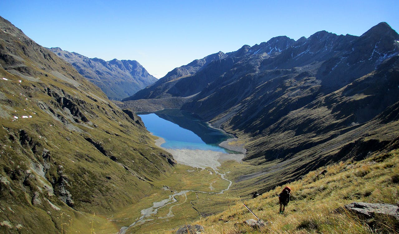
Find your way to the marked track leading to Travers Saddle and head to Sabine Forks, turning for Blue Lake.Blue Lake Hut, often busy, sits near Blue Lake – the clearest alpine lake in the world.
A long day awaits to reach the Matakitaki River. Climb above Blue Lake and past Lake Constance. Climb to Waiau Pass, 1870m. The next destination, Lake Thompson, is visible to the south-west.
Descend from the pass, then turn up-river, climbing tussock slopes to the lake. For many, Lake Thompson provides an overnight camping spot. If time is pressing, continue on over Thompson Pass and skirt around the head of the valley to D’Urville Pass and the Matakitaki River East Branch. Travel down-valley looks easy, but you’ll soon be battling waist high tussock mounds. Reaching the bush edge provides little relief: clear paths are rare and thrashing through clinging branches and undergrowth common.
Easy going is eventually found at the riverbed – about an hour out from East Matakitaki Hut.
From the hut, continue down-valley to the West Branch, passing Bobs Hut. After the hut, thick swatches of bush and a steep-sided gorge is negotiated. Emerging above the gorge, travel slows but is not difficult. Before the big bend in the river, strike out up the spur to avoid impenetrable bluffs. It’s a vertical two-hour grind to gain the ridge top – upward movement sometimes possible only by hauling on fistfuls of grass and dragging yourself metre by metre.
Three Tarn Pass – the final hurdle before the St James Walkway – is reached by traversing a mixture of easy grass slopes and rock slabs. Three Tarn Pass is not obvious from below, but by aligning the three bodies of water, an unlikely looking gap between rock outcrops can be spotted. The approach is steep and loose.
Descend to Ada Pass Hut and the St James Walkway – Lewis Pass an easy stroll down valley.
