
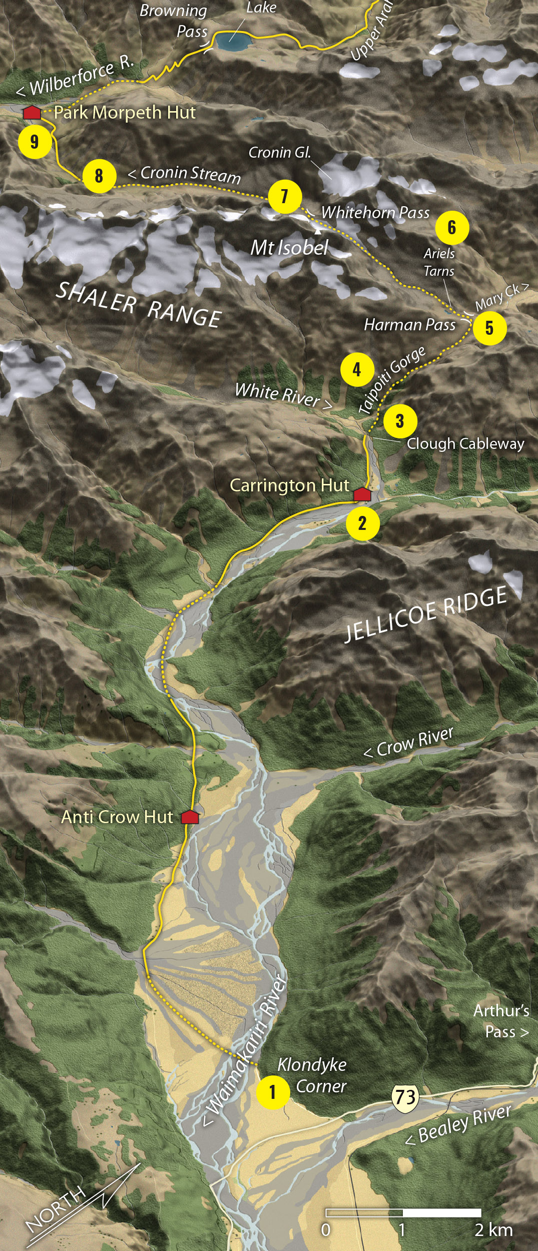
1 Klondyke Corner
The trip begins with an immediate ford of the Waimakariri River. Check river levels before you leave home.
2 Carrington Hut
Some parties choose to spend the first night here. It’s a big hut with greatviews of Carrington Peak.
3 Clough Cableway
This historic cableway will slow down big groups as it only takes one at a time. Better to ford the White River which can be done with care in low to average flows.
4 Taipoiti Gorge
The crux point of the route to Harman Pass, it’s slow and steep going through the gorge and will be difficult in high flows. Keep an eye out for the poled route, on the true left below the waterfalls in the upper gorge, to climb to the basin above.
5 Harman Pass
The 1321m pass is a beautiful location in fine weather. The route heads south-west from here, up to Whitehorn Pass. Don’t confuse it with the lower route down Mary Creek to the Taipo River.
6 Ariel Tarns
A place for photography and fine-weather camping, Ariel Tarns are in a stunning location beneath Mt Isobel, 2036m, which can also be climbed from here.
7 Whitehorn Pass
Take care on the snowfield leading to the pass as it can be icy and sometimes crevassed. The view from here is raw mountain vista, revealing the deep gulch of Cronin Stream and the Cronin Glacier.
8 Cronin Stream
Take care descending into the rough Cronin Stream. The lower part runs through a gorge which is bypassed by a marked track through the scrub on a river terrace on the true right. Keep a careful lookout for the trail markers.
9 Park Morpeth Hut
Park Morpeth offers basic comfort and shelter. There is a mountain radio located here (and at Carrington) should assistance or a weather forecast be required. The hut can easily be cut-off by rising rivers.
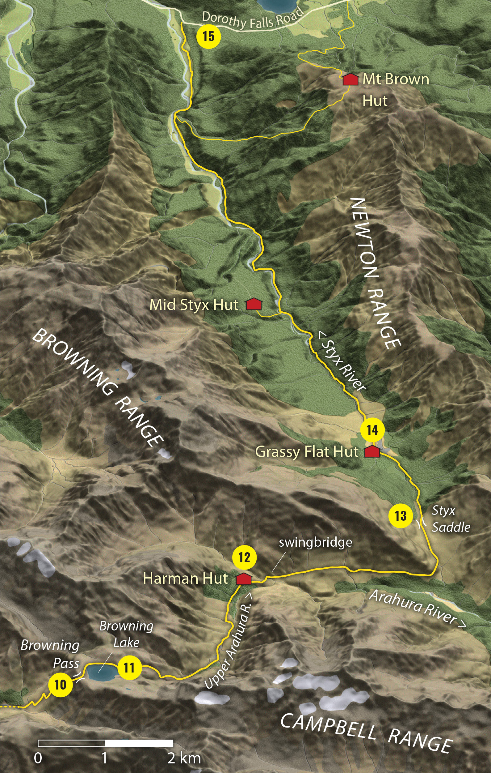
10 Browning Pass/Roti Raureka
Most regard this pass as the crux of the trip. It is a historic route forged by early surveyors looking for a dray-route to Westland in the late 19th century, hence the ‘zig-zag’ track which climbs its lower slopes. Higher up, the route is steep, rocky, and loose – though still with a discernible trail. Care is required not to send boulders tumbling downwards.
11 Browning Lake
Perhaps one of the premier alpine lakes in New Zealand, Browning Lake lies on a large shelf at 1360m, right on the crest of the Main Divide. It is a grand location and a superb site for a high camp in good weather. The poled route continues to the north into the upper Arahura.
12 Harman Hut
The usual stopping point for parties coming over Browning Pass, Harman Hut is sited in the upper Arahura, just above the bushline, and commands extensive views up and down the valley. Just north of the hut stands the spectacular Harman River swingbridge and the continuation of the historic pack track to Milltown Road.
13 Styx Saddle
This 760m swampy saddle connects the upper Arahura with the Styx River. There is a good track here and the turn-off is well signposted.
14 Grassy Flat Hut
This is a large and modern hut set in a clearing in the upper Styx. It’s a good stopping point for the last night (or the first). It has a quiet ambience and lovely views of the Newton Range.
15 Dorothy Falls Road
The Styx River has a well-marked track along the true right. Below where the Mt Brown track joins the main valley track, the river has eroded the bank and it is necessary to keep to the riverbed, walking beneath high shingle cliffs (beware of stonefall). In high flows, this section will be impassable. Be informed about current river levels before choosing the Styx as an exit/entry point. The Arahura River track to Milltown Road or the track via Mt Brown Hut provide alternative exit points.


