
The river now had a more sinister edge. Gone was the clear tranquillity. Before us was a swirling, coffee-coloured debris-strewn torrent, flowing twice as fast, and a good metre higher, than the day before.
None of us had any experience of paddling high-flow rivers and we were all intimidated, especially when a dead and very bloated goat floated past. We considered waiting for the water level to drop, but the impromptu measuring stick placed at the water’s edge an hour earlier indicated it was still rising.
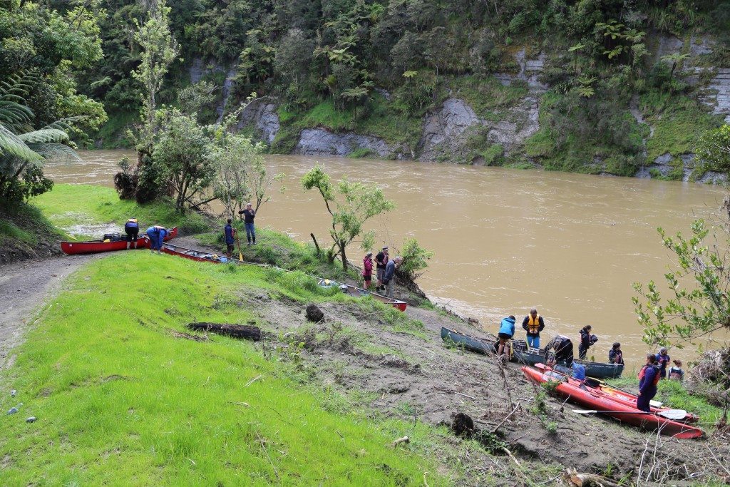
We all agreed – leave now and stick together. There’d be safety in numbers. So eight boats and 14 nervous paddlers lined up to face the music.
One of the great joys of any multiday trip is battling whatever elements are thrown your way. But compared to tramping – my usual outdoor medium – travelling on water magnifies the elements. A good dump of rain can turn a placid stretch of water into a murky, goat-strewn whirlpool. Conversely, it can also make a feared rapid disappear altogether. A headwind can make an easy saunter a gruelling day of hard work.
Your whole environment can be transformed by a change in the weather that on land could be a minor inconvenience. There’s a good reason why the ‘journey’ element of this particular trip is emphasised to such an extent. The unsettled climate, the extensive history, the characters you meet along the way, ensure every trip has its own unique story to tell.
All this was far from my mind when encountering my safety briefing on the opening morning of our Whanganui Journey. Here I was, staring at a whiteboard with what looked like a snake meandering from top to bottom. I was trying to find a part of my brain that could possibly retain information about avoiding a tree stump I’d encounter in two days’ time. Clearly recognising the beleaguered expression on my face, Jono – our instructor – decided to simplify things.
“If you’re approaching a rapid and in any doubt,” he said, “head to the right on day one, and to the left on days two, three and four.”
Even my limited brain capacity could remember that, I thought.
“Except for the very last rapid,” continued Jono. “Damn,” I exclaimed. “What do we do then?”
“On that rapid you aim for the right.”
Apparently we’d know it was the last rapid because the sign saying ‘500m to Pipiriki’ precedes it. This meant, in all likelihood, if you did fall in, you’d have an audience, many armed with cameras.
“On a hot day, falling in is great fun,” Jono added cheerily, as we all glanced outside to the impending drizzle that was to dominate our first day on the river.
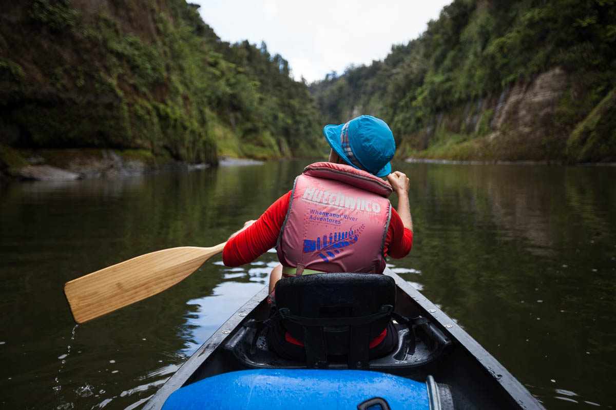
The Whanganui is normally paddled in three days from a miniscule settlement called Whakahoro. But there’s also a four-day option starting from Ohinepane campsite and a five-day option starting at Taumarunui. My girlfriend Lauren and I had decided to take the four-day option on advice of Jono – an instructor from Taumarunui Canoe Hire. My greater experience on the water (sea kayaking only) meant I was to sit in the back of the Canadian canoe and was technically ‘in charge’ – not a situation Lauren would normally accept, but one she was prepared to put up with so long as I guided us safely through any angry-looking water. I quickly learnt being in charge actually meant I’d cop all the flack if we tipped. The pressure was on.
Once making sure we looked comfortable in the water, Jono waved us off and promised to see us in four days time with a box of muffins.
Under his careful gaze from the riverbank, we immediately attempted the first rapid. We headed right (as advised), bounced a lot, got splashed, and then cheered as we sauntered past our first eddy; a harmless looking feature responsible for more boat tipping than the rapid itself.
Eddies appear to defy physics by heading upstream. Often situated either side of the rapid, if you veer off course during your descent you can find yourself experiencing a cold bath in such quick time you barely have time to gasp.
But we were through our first rapid and the journey had started. Beginning at Ohinepane was a fine introduction; plenty of rapids to get us into the swing of things, great rock formations either side of the river, and a real sense of entering somewhere special.
The rain never entirely let up, but our drenching was only a problem when we stopped for a break and began to shiver. A quick cup of tea and we were back on the water enjoying the mysterious sight of mist draped over faded hilltops.
For much of the day we were surrounded by farmland and were aware of back roads following the path of the river, but we rarely saw or heard a vehicle. Towards the end of the day, the forest became thicker and we felt further removed from civilisation. Just before reaching Whakahoro, our home for the evening, we travelled through our first proper gorge, with picture postcard views.
For us, reaching Whakahoro meant a long trudge from where we left the canoe to the bunkroom (350m is a long way when you’re lugging barrels of gear and food). But to river guide Jamie Anderson, this area is historically fascinating. Anderson, of Unique Whanganui River Experience, has been guiding on the river for 33 years and would have led Lauren and I had he not been recovering from a shoulder operation.
Instead, he took me through some of the river’s vast history prior to my trip, explaining how Makakote Pa, close to Whakahoro, was, in the early 1800s, the scene of a great siege between the down-river and the upriver Maori. It continued for so long that the upriver Maori (the tribe under siege led by Topine Te Mamaku) were running out of food. In desperation, they presented their children to the aggressors, who then took pity and left.
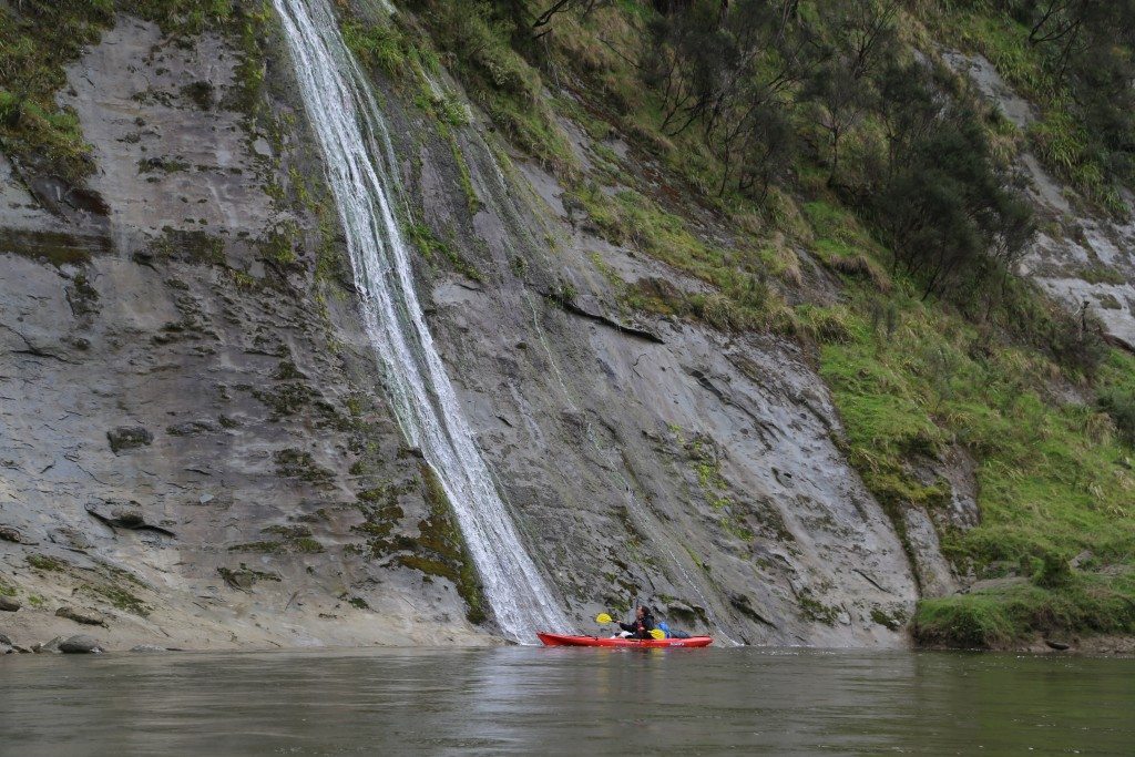
Earlier in the day, we’d enjoyed paddling to a small waterfall in the Ohura River, then past an open-top hill with two flagpoles standing prominent. “Back in the 1860s, the last of the serious Maori to Maori conflicts took place over the ownership of local flour mills,” explained Anderson. “A lot of people were killed in these conflicts and the poles were placed in memory of these battles.”
You can’t overestimate the river’s importance to the Maori of this region. Repeatedly, we would see the message ‘I am the river, the river is me’. One legend has it that the water flowing down the river heals the wound created by Mt Taranaki, who tore a path west after losing a fierce battle with Mt Tongariro over the beautiful Mt Pihanga.
Whakahoro bunkhouse was warm and dry – everything we needed after the first day. The setting was beautiful with the mist still rolling through the hilltops the following morning.
We joined two German kayakers, Maurice and Franzi, who were paddling in separate boats. Franzi had already fallen in – a great relief to us, as we’d been told one in three boats tip on the river, meaning statistically we were now safe.
Despite no great rainfall overnight, the river had risen almost a metre and we knew paddling would be significantly quicker than the day before. We soon entered the first of several gorges – beautiful and tranquil, with the faster water drifting us down-valley at a healthy rate. The rain had cleared, so we were no longer shivering uncontrollably on our occasional brew-stops.
Our big fear for the day – as warned by Anderson, Jono and our map – was making sure we avoided the tree stump to the right of the rapid immediately after Mangapapa campsite. “It’s like the tree stump’s magnetic,” Anderson had warned. “People tend to make a decision at the last minute, but the stump draws you towards it. I’ve seen kayaks wrapped around that and you normally need a jet boat to get them off. There’s plenty of room on the left if you make the decision fairly early.”
As soon as we saw Mangapapa campsite our anxiety grew and we hugged the left bank. The outcome was a laughable anti-climax, as a fairly tame rapid saw us bobbing harmlessly past the stump, wondering ‘is that it?’
The rest of the day was straightforward, as we headed deep into the forest. Several short, sharp rapids kept our buttocks clenched. One included Tarepokiore, also known as the whirlpool rapid. Dredging has tamed this rapid, but in years past it was notorious. Rapids normally disappear in high flow, but for some reason this one increased in size to the point where steamboats were sometimes turned right around. “It must have given the passengers a fright,” laughed Anderson.
These steamboats used to carry tourists from Wanganui to Taumarunui before they continued their journey to Central Plateau, Lake Taupo and Rotorua. Prior to the completion of the railway, the river was one of the tourist attractions. In 1906, 12,000 tourists travelled the river – compared to 7000 canoeists each year these days. The numbers dropped to the point where the river was almost forgotten about in the 1950s and 60s. “A friend of mine kayaked down in the 60s and had to hack his way to the Bridge to Nowhere,” said Anderson.
Since then, numbers have started to climb, but this increase has only ever been gradual. And unlike other New Zealand Great Walks, the Whanganui Journey seems more popular with locals than tourists. Over the Christmas holidays, the huts and campsites are packed, whereas in February and March there’s normally space which, combined with long days and warm weather, makes this an excellent time of year to go.
As we approached John Coull Hut we could see slip after slip on both sides of the river. These are scars from the colossal flooding experienced over the winter. The water level rose 9m and there’s an obvious line showing where the water swept away the vegetation. The storms turned dry forest bed into waterfalls and damaged many of the campsites and huts.
John Coull is a case in point. A slip between hut and campsite has swept away the trees to create an ugly tangle of branches and mud. It consumed the path and it’s a miracle the hut was unharmed – the only casualty being the toilets, which had just been replaced prior to our arrival.
At the hut, our group of four became 14 as we were joined by those who began their trip at Whakahoro. I spent the evening trying to explain the value of a good leave shot in cricket to a group of bemused Europeans. I must have been particularly boring because everyone was in bed by 9pm. No sooner had our heads hit the pillows than a downpour began which continued relentlessly until 6am the following morning when, as if someone turned the tap off, it stopped and we didn’t see another drop for the rest of the trip.
But it was clear from first light the river would be a different animal to the day before. There were a few nerves, as people figured out what to do. We all queued up and, one by one, were pushed out by the hut rangers into the debris-infested torrent.
We cruised downstream at a close to alarming rate. It was great fun and a good workout, as what would have been rapids the day before had now become a series of whirlpools. Staying on course was a struggle, particularly on one corner where those in front of us were heading in all sorts of directions and mostly facing the wrong way. After a few moments of wondering what on earth they were doing, we found ourselves caught in the swirling mess of currents, being flung to the right, then the left, before being spat into an eddy and moving upstream. As a group, from above, we must have looked like drunks, veering back and forth with no sense of control or direction. With a good deal of hard paddling and a little luck we forced our way through and continued south.
Before any of us expected to, we saw the sign to the Bridge to Nowhere. But, as we were on the wrong side of the river, the first six boats, including our own, missed it. We could only watch helplessly as we drifted away, wishing the final two boats luck in their desperate scramble to get their canoes to shore.
Missing out on walking the 45 minute trail to the bridge meant missing out on a fascinating part of the river’s history, where First World War servicemen and their families tried to farm this inhospitable area. “Imagine creating a farm from a jungle,” said Anderson. He described how they would have needed to clear the bush, burn it away in summer, seed the grass in autumn before finding stock to graze there. “It was hard work but they probably thought it was marvellous,” he added. “At least no-one was shooting at you, as they would have been in the war.”
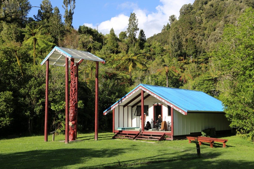
The disappointment of missing out on this trip was countered by the glorious ease of the remainder of the day – hardly a whirlpool in sight – and by arriving at Tieke Kainga Hut, campsite and marae early in the afternoon in perfect sunshine. The marae itself is situated right next to the hut with an enormous pou whenua, telling the story of the iwi, who greet paddlers to this day.
The site was presumed to be owned by the crown until the early 1990s when local Maori proved they had land rights at Tieke Kainga. This has led to dual-management of the hut and often a powhiri to welcome guests. This wasn’t the case this time, but our host Leianna and her two daughters greeted us warmly.
Of no small concern to us was that the All Blacks were due to play their World Cup semi final against South Africa at 4am the following morning. We’d been previously advised to try and make contact with Joe, who runs the Bridge to Nowhere accommodation over the river. So the evening prior to the game we called across. After rescuing some kayakers who had fallen out of their boats upstream, he came over to see us and, for a small fee, agreed to pick us up at 3.50am.
It was a successful morning with the All Blacks downing South Africa (20-18, in case you’d forgotten) followed by a breakfast of homemade potato bread with jam and whipped cream prepared by Leianna.
Back on the river, the first hour was the most beautiful of the whole trip, with the deepest, narrowest and most serene gorges. I’ve heard when the water’s low, and you’re against the wind, this section can be a struggle, as there isn’t much current to help you along. But we cruised through on the high flow.
It was truly relaxing, until we reached Ngaporo. Here, a long S-bend rapid drags you out to the left. I’d quickly learnt that the best way to tackle rapids when the water’s high is to just head straight down the middle. But one pair we were canoeing with chose to head left, where the current changed direction when ricocheting off the wall. It swept the front of their boat away and they took a swim.
In 1940, this rapid was the scene of a far more serious calamity. An overloaded riverboat carrying 214 cattle downriver began to tip. The cattle moved to one side of the boat causing it to capsize, killing three people and many more animals.
For our paddling companions, the only casualty was a Go-Pro. Once they’d emptied the water from their vessel they were back on the river and ready to tackle the final set of rapids before Pipiriki.
As the water was still high, they provided little trouble. Even the rapid ominously known as the ‘50-50’ was relatively benign. Autapu – the final rapid, also notorious – spat us out to the Pipiriki boat ramp, where our early arrival meant we waited a short while for the promised muffins to arrive.
Most slept on the journey back to Taumarunui, missing an outstanding view of the Central Plateau, the summits caked in snow. For every one of us, the trip had given us laughs, excitement, friendship, the odd dose of fear, a sense of achievement, and a far greater appreciation for how the mood of a big river can change day-to-day. It had, in more ways than one, been a journey we’ll rave about for years to come.
The best rapid Autapu (the final rapid); it’s challenging, with several big pressure waves which will either fill the canoe or tip it over! Great fun, especially on a hot sunny day
The best camping spot Mangawaiiti; a good climb but the camper is rewarded with a beautiful flat area, plenty of shade, or sun.
The most beautiful hour on the river The early morning with the river mist can be stunningly beautiful. Often quite cool, at 5.30am you can enjoy a beautiful dawn chorus
The best side trip (apart from Bridge to Nowhere) Mangaio Stream can be negotiated for around 400m. It’s very narrow with bush reaching across from each side, far above the paddler
The best time to go Mid-February; school is back, the river has quietened down a bit and the weather is usually stable and hot


