
Three mapping, navigation and route-recording apps to help you plan your next adventure. Read Part I of this review, titled ‘Which navigation app should you use?’
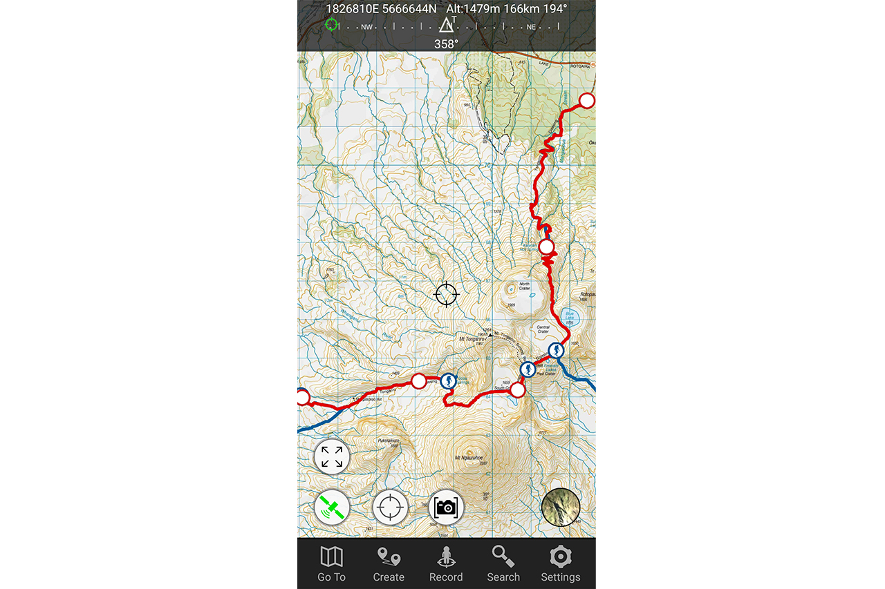
NZ Topo50 Offline North/South
$5.99 one-time fee per island / iOS, Android
Plusses: Easy to use, DOC tracks included, straightforward navigation
Minuses: Separate app for each island, minimal route creation and editing tools
Features: LINZ Topo50 maps; route-recording; full offline use; DOC tracks and huts included; AR peak identification.
Maps: This app displays high-resolution maps and aerial photography for New Zealand only. When zoomed out, the app shows 1:250,000 maps, but it changes to 1:50,000 scale when zoomed in. On my Android phone, the maps were seamless and smooth as I scrolled around. Aerial photography is a good feature, but resolution wasn’t high enough to be very useful except for an overview. I often use aerial photography to search for water sources, for example, and it’s not detailed enough for that. The optional peak finder overlay is great for mountain identification.
Route planning: The standout feature is that all DOC tramping and mountain bike tracks, campsites and huts are included, and are searchable. This is useful if you want to quickly find a track you’ve heard about, navigate along a DOC track, or differentiate between DOC huts and private ones. For Te Araroa walkers it’s a one-stop shop, because the whole route is included. Importing GPX or KML track files is straightforward. Once a track is imported or created, it can be closed, split or followed in reverse, but this is the extent of track editing features. Route creation in-app is basic and does not support auto-routing, so it’s only suitable for short point-to-point distances.
Route metrics: Both the included DOC tracks and user-imported tracks display a convenient elevation profile, along with total elevation gain/loss, as well as walking time estimations based on load, surface and fitness variables. But there is no way to select a portion of a track to derive distance or elevation.
Ease of use: This is one of the easiest mapping apps to use because all maps are included in high resolution when the app is downloaded (3.7GB for both islands, Android). This eliminates the risk of getting into the hills and discovering you do not have all the maps you need. Most options are self-explanatory, and navigating along a track, creating waypoints or seeing coordinates is simple. There is a small inconvenience to having to switch between two apps to see both main islands.
Value: The one-time fee for each island is reasonable. The app is developed in New Zealand and is updated regularly.
Verdict: Topo50 Offline has all the topo maps, all the time, and it’s easy to use, but sufficient space will be needed on the phone.
FatMap
Best for route visualisation
$94.99 per year (bundled with Strava Premium membership) / iOS, Android
Plusses: Easy-to-use interface, multiple map options, efficient route-planning
Minuses: Some actions are connection dependent, expensive
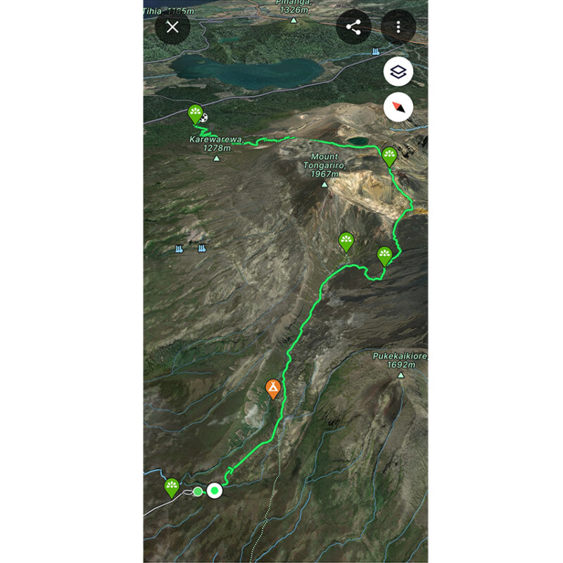
Features: Multiple maps and layers; route-recording; 3D visualisation; online auto-routing; online route library
Maps: FatMap’s default map uses detailed Google Earth-style 3D aerial photography with Open Street Map (OSM) road and track data overlaid. There are summer or winter options, allowing typical winter snow cover to be seen. Additionally, topo map layers can be loaded, such as New Zealand’s Topo50 maps or OSM Global Topo map. This will cover all the mapping data most people will ever need. There are also optional and customisable layers for avalanche hazard, aspect and elevation, among others. If a mapping app for 3D visualisation of terrain and routes is required, as well as topo maps with tracks overlaid, there is nothing better. Map areas can be downloaded for offline use.
Route planning: Many of FatMap’s planning features only work online, but it’s a fully functional route design app, allowing auto-routing or manual drawing of routes. Routes can be planned in any map mode too, including 3D aerial and Topo50 maps, with the advantage of switching between maps while you work on a route. Routes created are added to a library and can be public or private, but there’s also access to a global database of routes created by other users. Once a route is saved to a library, it can be loaded and used offline, provided the maps have been downloaded. Additionally, routes can be created with FatMap on desktop computers and synced with the app.
Route metrics: For any created or imported route, FatMap will display characteristics including distance, elevation gain/loss, maximum elevation and estimated duration. It also provides a scrollable elevation profile, but profiles between two points on a route can’t be inspected, e.g. the distance between two huts.
Ease of use: Despite being a powerhouse app, it’s designed for the average user. I figured out how to do most things without referring to documentation. Establishing alocation, initiating a new route, drawing one, adding waypoints and switching between maps is easy.
Value: FatMap comes bundled with a Strava Premium Subscription, which at $94.99/year is not a trivial cost. Both apps have limited but capable free versions.
Verdict: An excellent online planning app with class-leading visualisation tools and a large library of routes, but for backcountry use it’s best used with a less connection-dependent app such as NZ Topo50 Offline, Topo GPS or OsmAnd+.
Gaia GPS
Best for offline use with multiple maps
$56 per year / iOS, Android
Plusses: Many map styles, easy to use, lots of offline functionality
Minuses: No option for a quick inspection of distance, basic route editing
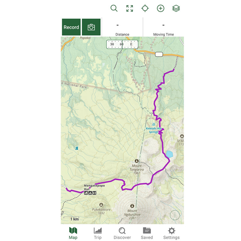
Features: Large range of maps and layers; route-recording; offline auto-routing; online route library
Maps: Gaia GPS is a popular mainstay app for offline Open Street Maps, but it also includes high-resolution satellite maps and NZ Topo50 maps, all of which can be downloaded simultaneously for offline use, either along a track to be followed or for arbitrary regions. All support a high level of zoom, which makes counting contour lines or inspecting features easy. There’s also a version of the satellite map with contour lines overlaid, a Trailforks MTB track map layer and a large number of maps for overseas.
Route planning: Drawing a route with a combination of manual lines and auto-routing is straightforward. Routes can be created offline with the requisite map area and offline data downloaded. The OSM map in Gaia GPS is one of the best for readability – it’s easy to see tracks, roads and other features. Once a route has been created, it can be exported to share or be opened in another app. Route import is straightforward, but route editing tools are limited to cropping the track, although in Gaia GPS desktop there is the option of reversing a track. The nitty-gritty of editing and joining tracks can best be exploited with Ride with GPS (desktop).
Route metrics: Easy-to-read elevation profiles, distance and elevation gain/loss are easily displayed for a loaded route, and when online a summary of the weather is also displayed. The elevation profile and map route can be displayed in tandem, so routes can be traced with a finger to see a visualisation.
Ease of use: It’s easy to read, with clear contour lines and POIs. The app functions are organised well and it only takes a few taps to figure out what everything does, so it’s quick to learn and suits beginner to intermediate map users.
Value: Gaia’s price is at the upper end of the scale, but it’s proven and comes with in-depth documentation.
Verdict: Gaia’s multiplicity of maps and useful features makes it a compelling option, especially for travellers, but I’d prefer more in-app route editing features for the price.


