
A good mapping app can provide accurate location, map reading and route planning.
Your cellphone is a powerful navigation and route planning device with accurate GPS and, with the right app, detailed maps that can be used offline. Paper maps are still essential, but a good mapping app can provide accurate location, map reading and route planning as well as a recording of your progress. These four popular premium apps, each with slightly different capabilities, can help you plan your next trip.
OSMaps (featured)
$55 annually / iOS and Android
Plusses: Easy to use, three types of map data, database of routes available.
Minuses: Functionality when offline is limited.
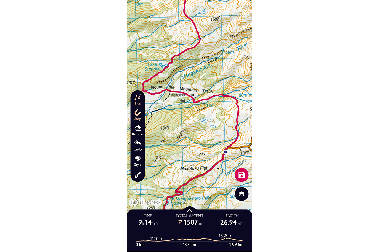
Maps: OSMaps provides three different map types: Standard (Open Street Maps), Premium Topo (LINZ Topo50 maps) and aerial imagery. The Premium Topo maps can be downloaded for offline use. However, map data is also cached as you scroll around the maps. Maps render and scroll smoothly once loaded, but the Standard map is quite simplified and you have to zoom in to see details. There’s a nifty augmented reality feature (online only) that overlays the names of land features on the screen as a scene is viewed with the phone camera.
Route planning: Route plotting only works while you are online, but once a route has been created in-app you can follow it in the field. Route plotting is intuitive and simple and there’s seamless switching between ‘snap’, which follows existing tracks, and freeform line drawing. The mapping engine used for route creation is Open Street Maps (OSM), so even though you might be using the Topo50 map as the basemap, some locations won’t ‘snap’ to the track if OSM coverage is limited. For example, I easily routed a trip in Tongariro National Park, but OSM data was lacking for another trip in the Hokitika backcountry. GPX track import can only be done via a desktop computer, but you can export GPX tracks from the app, as well as edit them in-app.
Route metrics: OSMaps provides easy-to-read distance and elevation profiles, as well as total elevation loss/gain along a planned route but there is no way to make a quick distance/elevation measurement along part of a route when offline.
Ease of use: OSMaps has a slick, well-designed interface with easily found features. Along with route creation tools, you can also search (when online) the OSMaps database for public routes which can be loaded and followed. These include walking, trekking, cycling and horse routes. While the app is easy to use, it’s also limited. For example, there is no capacity to configure the Standard map to make it easier to read, or to import GPX tracks directly into the app. If there is a way to mark and save individual waypoints, I couldn’t find it. This is a basic feature any mapping app should have.
Value: OSMaps could be considered expensive for a limited feature set, unless extensive use is made of the route database for uploading personal routes and downloading others.
Verdict: OSMaps’ biggest strength is the quality of the app design and its simplicity. There’s no content buried deep in menus and the titles of the functions are not cryptic. The maps render smoothly and the Premium Topo map is high quality, but the app’s features will be too limited for some users.
Osmand+
$40 one time fee / iOS and Android
Plusses: Configurable, offline import, export and route editing, map file sizes are small.
Minuses: Some features are not obvious, Topo50 maps are not available.

Maps: Open Street Maps (OSM) is the engine that drives OsmAnd+. The benefit of OSM is that it’s open source and users are constantly contributing new and updated data to the map, which regularly updates in-app. For some parts of the world, it’s the most detailed map, but some regions have more limited coverage, especially in terms of walking tracks. The app supports other international map types, including detailed aerial imagery, but LINZ Topo50 maps are not available. OSM maps are highly configurable so you can emphasise roads, tracks, track types or contour lines, depending on preferences. The maps are vector-based and relatively small file sizes, so all of New Zealand can be downloaded without taking up a ton of space on your phone. Aerial imagery can’t be downloaded by region for offline use, but specific areas can be reliably cached by scrolling around while online.
Route planning: As long as the track or road is in OSM, OsmAnd+ can follow it online or offline for route planning at home or in the field. For tramping in Tongariro National Park or the Tararua Range, for example, OsmAnd+ is reliably routable, but for more remote areas some tracks are not on the map. Roads and 4WD tracks have good coverage making OsmAnd+ excellent for bikepacking, but less so for tramping, although it depends where you’re going. Waypoints can quickly be added and configured in different categories or collections. The app supports offline import and export of GPX and file manipulation (such as reversing) as well as in-app offline route creation and export.
Route metrics: It’s very quick to produce distance and elevation metrics either along a potential route when you’re offline and in the field or along a GPX that’s been loaded to the app. Elevation profiles, gradients, even road surface types are provided.
Ease of use: It has a steep learning curve and many features are not immediately obvious (like how to use aerial imagery). However, initial setup and downloading of maps is obvious and the user guide is comprehensive so it’s possible to get started quickly before learning more features.
Value: For the app’s feature set, the one-off fee is reasonable if offline maps are used regularly.
Verdict: This is not the best for those who want to get completely familiar with an app quickly, but for power users it offers a complete tool set. For some New Zealand tramping areas it’s best used with an app that supports Topo50 maps, such as NZ Topo50 Offline ($5.99), but for cycling use it should be all that’s needed.
MapOut
$8.99 one-time fee / iOS
Plusses: Quick to learn and fast to use, excellent value, map file sizes are relatively small.
Minuses: Only one map type supported, iOS only.

Maps: MapOut uses a beautifully rendered Open Street Maps-based map with contour lines and hill shades to produce a map that looks similar to a Topo50 map, including 3D rendering. It supports only one style of map though, so if you want actual New Zealand Topo50 maps or aerial imagery, it’ll need to be combined with another app. As with OsmAnd+, this means the detail of New Zealand tramping areas will vary. If you tramp in popular areas it should be sufficient, and in some locations it’s more accurate than Topo50 maps. For cycling routes and cities it’s very detailed. Map tiles can be downloaded for reliable offline use.
Route planning: For plotting potential routes or assessing an uploaded route, MapOut is the fastest to use of all apps reviewed. The interface is quick and smooth. It allows a finger to be traced along a potential route, or for beginning and end points to be added. As long as the potential
trip is routable it will create a line and can then be saved. Routes can be adjusted by dragging a finger from the route the app has chosen to the route you want to follow. Walking routes, cycling routes or road size can be prioritised when making routes. Route editing tools are limited, but an imported GPX or app-created route can be reversed.
Route metrics: As a finger is traced along a route, distance and elevation gain/loss is displayed in real-time. A quick assessment of terrain can be done by holding two fingers on the screen to gain a point-to-point elevation profile. While the elevation profiles are fast and accessible, they’re not detailed.
Ease of use: MapOut has a user-friendly interface and uncomplicated menus that make most mapping tasks easy to figure out. The online documentation is detailed and easy to understand, helping users get up to speed quickly.
Value: Good value for its ease of use, quality and feature set.
Verdict: MapOut has a great interface and a set of features that will cover most people’s mapping needs for planning walks, tramps and rides, but pair it with an app supporting Topo50 maps for a complete view of terrain.
Topo GPS
$6.50 per map type / iOS and Android
Plusses: Good value, especially with just one or two maps, easy to learn, most of the tools most users will need.
Minuses: Added maps increase the cost, OSM map is not easy to read, tools are basic.

Maps: Topo GPS can use Open Street Maps (OSM), Topo50 maps or aerial imagery all within the app, with just two screen taps required to switch between each map mode. The OSM maps are complete, with 10m contour line spacing, but they are basic in their rendering. I found tracks hard to see. You can’t configure anything about the map’s appearance except turn hiking and cycling overlays (generally well-known tramps and cycle trails) on and off. Each overlay costs $4.50. Topo50 maps are clear and scroll smoothly once loaded. Compared to some apps, the aerial imagery is slow to load, but it’s clear and detailed.
Route planning: This app supports route plotting and routing within Topo50 and OSM. However, track data is OSM based so, as with OSMaps, if the OSM data is flawed or not present, routing along a track, even if it is visible in Topo50, is not possible. Manual drawing is available (called Crow Fly in the app) to overcome this, or routes can be plotted in trackless terrain. Plotted routes can be saved offline, in-app, and, when online, routes saved by other app users can be downloaded. At the tap of a button, the map required for that track downloads automatically. Waypoint creation is as simple as making a long press and then naming and saving the point, but there’s no categorisation available.
Route metrics: Once a route has been plotted, it can be saved and viewed in Saved Routes, where length, elevation gain (but not loss) and profiles for elevation and gradient can be viewed. However, there is no way to glean distance or elevation for a section of a route without redrawing it.
Ease of use: Overall, the menus, the functionality, the basics of this app can be mastered quickly – such as offline importing and exporting of GPX. Track editing controls are limited. There is an option to reverse a track, but a couple of menus have to be dug into to find it. There are no other options, such as joining tracks.
Value: With OSM, Topo50 and aerial imagery options all activated ($19.50 total) this app is good value, but the cost soon adds up if more maps for other countries or hiking and cycling layers are activated.
Verdict: Topo GPS is well-designed and smooth enough to use, but the interface and OSM rendering is not as nice as some other apps. A little more customisation and faster/deeper route analysis would be useful. Overall, it’s an app well-suited to most recreational users.


