No-one knows the conservation estate better than the rangers who work it, explore it and live in it day after day. Wilderness convinces some of them to reveal their favourite hideaways – the special spots that calm the nerves or drop the jaw.
1. Alpine idyll
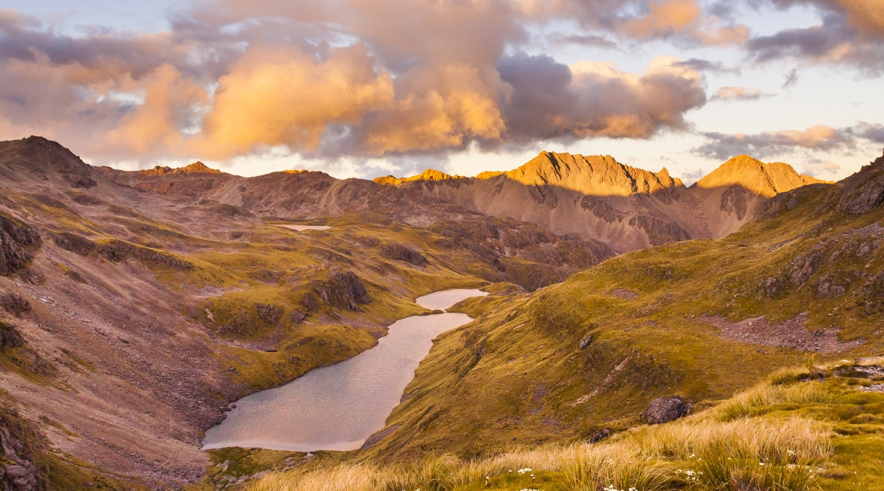
Hinapouri Tarn, Nelson Lakes National Park
Ranger: Martin Rodd
Lake Angelus deserves its popularity. The vision of the lake, hut and steep sided alpine summits is one of such outstanding beauty it attracts thousands of visitors over the summer.
What most people don’t know is that, less than an hour’s walk from the lake is another alpine tarn in an equally beautiful environment – but pack a tent and the likelihood is you’ll have it all to yourself.
It’s a rough sidle down the scree slope to Hinapouri Tarn, but once you’re there you feel a million miles from anywhere, says Rodd. “When you’re in the basin you can’t see any human modifications at all – just a spectacular alpine environment.
“It’s just a hop, skip and jump from Angelus Hut, but you’d have no idea it was so close. It’s a little gem of its own with a smaller, more close-up feel. And when you get to the southern side you see a beautiful cascade running down the hill into the tarn.”
Time 14hr return Grade Moderate
2. Island sanctuary

Moturua Island and Motukiekie Island. Photo: Lara Kay PhotographyMoturua Island, Bay of Islands
Ranger: Helen Ough Dealy
Right in the middle of the Bay of Islands is a must-see island on a kayak trip around the archipelago. Moturua Island has sandy beaches, a stunning round-walk and is home to an enormous number of native birds, thanks to it being part of Project Island Song.
The island is unrecognisable from five years ago when predators ran free. Now, the burgeoning wildlife has created an interactive experience.
“It has just had the North Island robin reintroduced, which is doing very well,” says Ough Dealy. “When you get near to the island you can hear the bird song – I was on a boat 200m off shore, played the North Island robin song, and they sung back to me.
“These birds go right up to you. It’s an intimate experience. The island’s in the middle of the archipelago and the walk gives you great vistas out to sea and over the islands.”
There’s no camping on the island, though nearby Urupukapuka Island has three campsites at which you can stay.
Time 2½hr walk Grade Easy
3. Rare treat

Kohukohunui, Hunua Regional Park
Ranger: Ali Meade
Hearing the mournful song of a kokako is one of the most beautiful and haunting experiences in the New Zealand bush. It’s also one that’s now
extremely rare, as the species is so vulnerable to predators.
But there’s one spot close to Auckland where you have a very good chance of hearing the eerie cry. That’s on the highest summit in the mainland Auckland region – Kohukohunui.
The peak has a platform at the top with views of Hauraki Gulf islands, the Coromandel Peninsula and surrounding forest. It can be reached as part of a long day walk to and from Waharau Regional Park, but Meade recommends staying overnight.
“There’s a campsite on Mangatangi Ridge Track, where it crosses the stream, called Thousand Acres Camping Ground,” she says. “If you get up early in the morning and walk up to the summit you’re far more likely to hear the kokako than in the middle of the day.”
In 1994 there was only one breeding pair in the park but the latest survey counted 59 pairs thanks to intensive predator control carried out by Auckland Regional Council. Most of the pairs live around, and west of, the summit.
Time 6-9hr Grade Moderate
4. Raw power

Tree Trunk Gorge, Kaimanawa Forest Park
Ranger: Harry Keys
A powerful experience for those heading along SH1, east of Tongariro National Park, is to stop at Tree Trunk Gorge. It’s just five minutes from the main road and another five-minute leg-stretch to the fantastic sight of water gushing through a narrow gap just inches from where you’re standing.
Park your car just before the bridge over the Tongariro River on Tree Trunk Gorge Road. A track (not signposted) on the true left of the river leads down to the gorge almost underneath the bridge. First, head through vegetation which has been clearly trimmed by previous floods.
“Below the vegetation the track drops into a big amphitheatre,” says Keys. “It’s a big empty space with water-worn lava. Go as far as you can along the river where the water thunders down only a metre away from you – it’s very powerful. The whole place is very impressive.
“It’s a neat local gem, but if you’re accident prone, don’t go there because there’s no fence and if you fall, you die.”
Time 10min Grade Easy
5. Grand little canyon

Tephra rocks, Tongariro National Park
Ranger: Harry Keys
Not many people know that New Zealand has its very own mini-Grand Canyon. It’s one of the more colourful aspects of the Rangipo Desert. In a region that mostly consists of small shrubs and grey soil, it’s hard to imagine an explosion of colour.
But head 6km up the orad towards Tukino ski field and you’ll see something rather different. Drive as far as the 4WD sign and you’ve reached the terminal moraine of the Mangatoetoenui Glacier. You can wander through the foothills and admire the tephra layers in the rock, formed by Mt Ruapehu’s dramatic volcanic past.
“It’s an extreme environment, which was disturbed by lahars in an eruption 400 years ago during a very active phase of Ruapehu’s history,” explains Keys.
“Over the years the rock has eroded into small, gently sloped landforms and consists of orange and brown layers of sand and pebbles. It’s only vertical to 5m and is a very colourful place.”
Time 10min Grade Easy
6. Dramatic erosion

Pyramid Stream, Egmont/Mt Taranaki National Park
Ranger: Dave Rogers
The almost-perfect conical shape of Mt Taranaki is a sure-fire clue that, geologically speaking, it’s an infant volcano. Another clue is the rapid rate of erosion, particularly on its western side. Nowhere can this be seen more dramatically than Pyramid Stream – or, to be more precise, Pyramid Gorge.
Every time there’s a significant rainfall (and that’s pretty common in this part of the country) big lahars swoop down the hillside taking a significant chunk of the brittle mountain with them.
In the last five years alone the gorge has extended a further 2.5km up the mountainside and it’s now starting to eat into the lower slopes of the landmark known as Little Pyramid.
“Once it consumes the Pyramids it will be in to the steeper western scree slopes and will quickly make its way to the summit,” says Rogers. “This is something we are likely to witness in our lifetime.”
The quick erosion created a headache for DOC, which had to constantly re-evaluate the path of the Round the Mountain Track. In the end, they had to settle for bringing it down to bush level, so as not to send trampers into high alpine conditions.
So, where’s the best place to see this natural phenomenon? “From the air, if you can,” says Rogers. “Failing that, you can walk up the Kahui Track then head across to the Pyramids from there. This will take around 3-4hr to walk in and another 2½-3hr to come out.
I wouldn’t recommend walking up the stream. There are huge cliffs 20m high and you can see and hear them collapsing all around you.”
Time 5-7hrGrade Moderate
7. Remote Tararuas

Tarn Ridge Hut, Tararua Forest Park
Ranger: Joe Hansen
One of the more hard-to-reach huts in the Tararuas is Tarn Ridge Hut. It’s a full day’s tramp from the Upper Waingawa Road end and involves negotiating Mitre, the park’s highest summit. But the reward for such efforts is a feeling of remoteness rarely experienced on the tops.
“You’re in the middle of it all,” says Hansen. “At night you can’t see the surrounding townships or any lights – you’re surrounded by mountains.”
Hansen warns to check the weather forecast before you go. “If the weather packs in, it’s reasonably hard to get back out because you don’t want to head over Mitre and the rivers in flood aren’t much fun either.”
Time 2 days Grade Moderate-difficult
8. Lose the crowds in Abel Tasman

Falls River, Abel Tasman National Park
Ranger: Martin Rodd
An excellent side trip while either walking or kayaking the Abel Tasman Coast Track is a lesser-known track that heads inland to Falls River.
Falls River Track starts from the far western corner of Torrent Bay, following Tregidga Creek, before rising over a small hill and dropping to Falls River itself.
“The cascading river provides multiple amazing swimming holes as you hop your way up to a spectacular series of waterfalls,” says Rodd. His favourite spot of all is the final swimming hole you can reach upstream without needing more specialist gear.
“Boulder hop up the river until you reach an obvious swimming hole at the base of a waterfall – it’s great for swimming,” says Rodd. “If you’re doing the Coast Track, leave your packs at Anchorage Hut and head there for a half-day return trip. Top tip: make sure you go at low tide, or the walk will be considerably longer.
“This trip gives you a real feel for this section of river and gets you into mature forest undamaged by previous forest burning which affected most of the park.”
Time 3-4hr Grade Easy-moderate
9. Spectacular Kahurangi
Mt Luna, Kahurangi National Park
Ranger: Martin Rodd
As most who have been there will know, Kahurangi National Park is vast. It’s a magnet for trampers who want to experience a world devoid of humans; where you can stand on a summit and see no sign of civilisation.
One such summit, which can be enjoyed over a long weekend, is Mt Luna. Access to the mountain is reasonably straight forward and safe, now that DOC has placed a bridge over Kiwi Stream on the return leg.
Start along the Wangapeka Track until Stone Hut. After a stream crossing, head up the Mt Luna Route into a basin, then on to the tops and the summit of Mt Luna.
“The scenery is spectacular at first light,” explains Rodd. “You look into the Karamea on one side and across to Patriarch on the other. You can’t see beyond the park so you get a real sense of remoteness. On Patriarch you feel closer to civilisation.”
After making the summit, there’s the option to continue east towards Kiwi Saddle Hut. From here, if the weather’s good, you can continue back to the car along the tops, via Mt Patriarch and the Arthur Range. Otherwise, DOC’s strategic bridge comes into play and trampers can escape back to the Wangapeka Track by heading down Kiwi Stream and crossing close to where it joins the Wangapeka.
“Mt Luna is a walk, not a scramble,” says Rodd. “It’s classic Kiwi tramping. Two nights would make the trip very comfortable. It can be done as an overnighter but you’ll be on your feet for a long time.”
Time 2-3 days Grade Moderate

Mt Rintoul Hut, Mt Richmond Forest Park
Ranger: Martin Rodd
If you’re looking for a perfect place to catch the sunset then you could do far worse than spend a night in Mt Rintoul Hut. Situated in one of the harder-to-reach spots of the Richmond Range, the hut’s namesake mountain towers above and is a great climb at first light.
Rodd recommends walking in via the Wairoa River Left Branch and out again via Old Man and Mt Starveall for a thoroughly rewarding 2-3 day tramp.
“Rintoul Hut is a six-bunker and always immaculate,” says Rodd. “It looks straight out over Mapua, the Arthur Range and Tasman Bay. Try and catch it when the sun’s going down – it’s a cool spot.”
The trip is more of a route than a track, but heads through a beautiful gorge on the way to Mid Wairoa Hut, after which you’re straight on to the tops. “Bishop’s Cap has bizarre forest at the edge of ultramafic country and Purple Top is like being on the moon,” explains Rodd. “It’s a weird landscape.”
Rodd says it’s a fine-weather trip only. “The first time I did the trip was in the cloud and I couldn’t believe what I’d missed when I struck clear skies the second time round.”
Time 2-3 days Grade Moderate
11. Peninsula peak bagging

Mt Sinclair, Banks Peninsula
Ranger: Wayne Beggs
Banks Peninsula is teeming with paper roads, many of which have never been formed. One paper road, which was used as an old stock route, has been turned into a walking and mountain bike track, and will soon be part of a three-day trip taking in some of the peninsula’s highest points.
The three-day trip will start at Gebbies Pass and trampers can stay at Packhorse Hut, Waipuna Hut (currently being built) and finish at Montgomery Reserve.
There’s a beautiful five-hour stretch called Twin Fencelines Track which goes from Western Valley to Montgomery Reserve. It can be done in a day, of course, but Beggs recommends camping on the northern side of Mt Sinclair.
“You get great views over Mts Fitzgerald and Herbert,” he says. “There’s no light pollution up there and you can’t see houses at that spot, so it has a real wilderness feel.
“There are a few flat spots close to the track that are good to camp and when it’s cloudy in Christchurch, and an easterly is blowing, the cloud can rise from Pigeon Bay and spill over the saddle and into the river catchment the other side before burning off. It’s a beautiful sight.”
Time 5hr Grade Easy-moderate
12. Unbeatable views
Hoophorn-Worryline Traverse, Aoraki/Mt Cook National Park
Ranger: Ray Bellringer
Aside from the trip to Mueller Hut and a few shorter tracks, many believe there’s little for trampers in mountainous Aorkai/Mt Cook National Park. It’s true the park contains plenty to benefit those with climbing ropes and ice axes, but there are also plenty of tramping gems if you know where to look.
One of those is the Hoophorn-Worryline Traverse, a day trip that can be tackled either way from SH80 several kilometres south of Mt Cook Village and includes a saddle at 1460m which offers fine views of the park’s highest mountains.
“The views of the likes of Aoraki/Mt Cook and Mt Sefton are great from the saddle because they’re more distant, which gives you a greater perspective,” says Bellringer.
Another benefit is it’s weather-beating location: “Further east you tend not to catch the weather and it’s often clear, even when it’s raining in the village.”
From the saddle you can climb to the summit of Mt Hodgkinson, the lowest named peak in the park. There’s also good access from the saddle to Mt Edgar Thomson for climbers.
Head up Birch Hill Stream from SH80 on the true left and follow the stream that veers right towards Point 1488. This is known as the Worryline Stream. From the saddle, head down to Hoophorn Stream and follow it back to SH80, just 4km from where you started.
Time 6-8hr Grade Difficult
13. Mountains, tarns and wildlife

Walker Pass, Arthur’s Pass National Park
Ranger: Sandy Tong
A blend of snow-capped mountains, gorgeous tarns and a chance to spot or hear several of the country’s rarest species, makes the track to Walker Pass a superb overnight trip.
From Hawdon Hut, 3hr up valley from the road end, it’s a 30min trip from beech forest up Twin Fall Stream to alpine habitat and 2hr to the pass itself.
“You’ll walk alongside a meandering stream through subalpine scrub dwarfed by raw and majestic snow-capped mountains,” says Tong. “There are various large tarns along this route with plenty of flowering Mt Cook lilies in November. There are also impressive stands of the Doctor Seuss lookalike tree, mountain neinei.”
A trap line along the route has helped to protect vulnerable species in the valley, including the whio/blue duck, great spotted kiwi, rock wren and the extremely rare orange fronted parakeet.
Time 10hr Grade Moderate
14. Perfect location
Lake Christabel, Victoria Forest Park
Ranger: Dave Hawes
A number of rangers selected this as their favourite hideaway. Lake Christabel is one of those peaceful places the locals rave about while, at the same time, would rather people didn’t know existed.
“It has that X factor,” says Hawes. “It’s impossible to put your finger on what it is exactly that makes it special.
“The closest I can describe it, is that this place has an aura of peace, tranquillity and well being and you absorb that feeling when you spend time there.”
The lake is a three-hour walk along Blue Grey River from Palmer Road. Thirty minutes beyond the lake is Lake Christabel Hut.
“On a scale of 1-10 when Christabel is a 10 nothing else ranks above a five,” says Hawes. “This is no mean thing, as we work in some pretty nice spots.”
Time 6hr Grade Easy-moderate
15. Reef stars
Thirteen Mile, Greymouth
Ranger: John Reid
Low tide may not be the best time to see waves shooting up blowholes in Pancake Rocks at Punakaiki, but it’s the best time to spot this hidden gem off Coast Road, between Punakaiki and Greymouth.
Just 10-20min walk south along the coastline from the small collection of baches at Thirteen Mile Creek (between, you guessed it, Twelve mile Bluff and Fourteen Mile Bluff), takes you to a rock shelf where thousands of mussels feed off the rock. Feeding on them are scores of starfish creating a colourful spectacle.
“Most locals know about it,” says Reid, “but not many visitors. It’s unique to this part of the West Coast.”
Time 20-30min Grade Easy
16. Mudstone canyon

Ford Creek Chasm, Blackball
Ranger: John Reid
How many towns could boast an accessible gorge which you can walk to from the town centre? Ford Creek Chasm is right next to Blackball and you can access it opposite the disused quarry on Roa Road.
A steep, unmarked track leads to the gorge, then you can enjoy a fun trip down the canyon. No ropes are needed – there are no waterfalls – just a wetsuit and some good footwear. There are some pools on the way and the canyon should definitely not be tried after heavy rain, but in good weather it’s a straightforward descent.
“Most other canyons in the region have schist rock,” says Reid. “But this is in mudstone and the formations and colours that have been created look remarkable. It’s not difficult but the water’s pretty cold.”
Time 2hr Grade moderate
17. Isolated arch

The Hole in the Hill, Charleston
Ranger: John Reid
Think archways on the West Coast and most people think Oparara. But there’s another further down the coast which is not signposted and has no proper track, but which Reid believes is even more interesting than its better known cousin.
The Hole in the Hill only takes around an hour to reach from Darkies Terrace Rd, if you know where you’re going. The trip starts along a forestry road but soon requires good navigation skills and an ability to avoid sink holes to reach the target.
Once there, you’ll have reached a true hidden wonder. “It’s eroded over thousands of years but the roof’s still intact,” says Reid. “It’s not as big as Oparara but you can clearly see how the water’s eroded through the rock and you can see the timelines in it. The spot’s isolated and not many people find it.”
Time 2hr Grade Easy
18. Bad weather getaway
Makarora Hut, Mt Aspiring National Park
Ranger: Simon Mazzotti
Much of Mt Aspiring National Park is well known. Last year Wilderness readers voted it as their favourite park and the likes of Liverpool Hut, French Ridge Hut, Mt Brewster and Cascade Saddle are classics.
But there are plenty of lesser-trodden valleys if you look closely enough. One of those is the Makarora Valley off the Haast Pass Highway.
Access is from a track beginning at Kiwi Flat (if the river is low, a short cut from Davis Flat is possible). Just six hours upstream is the little Forestry Service-built Makarora Hut – a quick getaway for Mazzotti.
“It’s my overnight escape,” he says. “It’s removed from everything in an accessible sense. For me, it’s about not seeing evidence of humans and, apart from the hut, that’s exactly what you get in this valley.
“If you’re planning an alpine trip up Mt Brewster, say, and the weather’s not good, then this is a great alternative. It’s not a first-timer walk but is a good tramper’s track not used very often. It’s certainly an alpine environment and it’s very sheltered too.”
Time 12hr return Grade Moderate
19. Wild Rakiura coast
Big Hellfire Beach, Rakiura National Park
Ranger: Phred Dobbins
Rakiura isn’t short of wild, untouched locations around its coastline. It’s why many choose to visit for epic week- or fortnight-long excursions.
But there’s one spot ranger Phred Dobbins says is particularly dramatic and a terrific place to spend an evening – although it’ll take at least three days to get there.
Big Hellfire Beach lies just off the North West Circuit and the only way to reach it is down a 365m sand shoot (bring your boogie board if you can bear to carry it all that way).
The beach at the bottom is small, but broken reefs off-shore create an angry scene of white water and the loud crash of waves, which the reef helps to mellow by the time they reach shore.
“You’re quite safe, even though you look up at huge pounding waves,” says Dobbins. “It’s a small golden sandy beach surrounded by cliffs. It’s a rough spot but that’s part of its beauty – you experience the raw power of the ocean.
“There’s also a rock cave/overhang at the southern end of the beach with a small rock protruding from the ceiling that looks like a skull, which is a bit spooky.”
The beach is also at the perfect angle for enjoying sunsets before making the painful ascent back up the sand to Big Hellfire Hut.
From Halfmoon Bay it takes around three days to reach clockwise or five-six days anti-clockwise.
Time 8-9 days Grade Moderate
20. Holiday town’s holiday lake

Mavora Lakes, Mavora Lakes Park
Ranger: Sinead Mulhern
Forty years ago it could take up to a day to drive from Te Anau to South Mavora Lake and the much larger North Mavora Lake. These days, the trip can be made in 40min and in summer the locals love to camp there and kayak on the water.
“It’s stunning to drive in there,” says Mulhern. “After passing kilometres of rolling farmland you turn-off the road and drive through native bush, catching glimpses of sparkling water through the trees.
“Then suddenly you pop out of the bush and this magnificent vista opens up in front of you; beautiful rolling tussock and blue water with the Livingstone and Thompson mountains standing guard on either side.”
The region has its own micro-climate that’s far more akin to Otago’s weather patterns, rather than Fiordland’s.
The Mararoa River, north of the northern lake, has plenty of trout and keen trampers can head north along the Mavora Walkway all the way to the Greenstone, Caples and Routeburn tracks. The stretch of river between the two lakes also offers a fun, gentle kayak trip.
Time Accessed from road Grade Easy
21. Ice age remnant

Monument, Fiordland National Park
Ranger: Ken Bradley
Protruding from the shores of Lake Manapouri is a striking little summit, formed as the core of an ice whirlpool. Quite how it survived the glacial attack is uncertain but those who make the climb are pleased it did.
It can be seen from many spots in Manapouri township but a kayak or boat is needed to reach it. There’s a useful portage, where it takes 10 minutes to wheel your kayak over from Surprise Bay to George Bay. Then Monument rises steeply from Rawiri Bay.
“It’s a neat place to kayak because there are a lot of inlets and the portage trail is really handy,” says Bradley. “The climb is up a marked route, rather than a track.
“There’s a wee rock challenge on the way up with a chain to help. There’s a great view from the top and a fit person should make it up there in an hour.”
Time 4-5hr kayak, 2hr walk Grade Moderate

34 years of inspiring New Zealanders to explore the outdoors. Don’t miss out — subscribe today.

Questions? Contact us


