Right on cue, the long dry summer came to an end. It wasn’t thunderous or biblical, just a persistent, drizzly, misty end to the golden weather.
I’d raced the dark clouds along the gravel back roads between Owaka and Balclutha to get to the start of the Catlins River-Wisp Loop Track – a recently opened 24km, two day walk – before the rain set in. But barely had I beeped the car locked and before it began to drizzle. Putting on my wet weather gear, I realised I might as well have taken my time – at least that way I wouldn’t have missed the turn-off to The Wisp and driven halfway to Balclutha before realising my mistake.
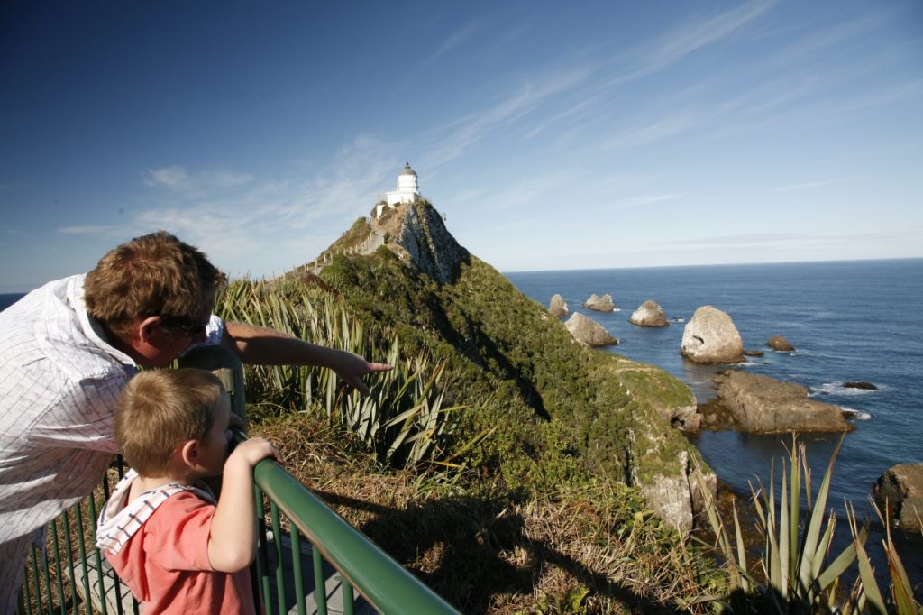
But then, I’m not the first to be in a rush in the Catlins. Take a drive along the Southern Scenic Route between Dunedin and Invercargill and you’ll see plenty of tourists. On my first day in the region I visited all the hotspots: Cathedral Caves, Lake Wilkie, McLean and Purakaunui falls and Nugget Point Lookout. By the time I’d watched the yellow-eyed penguins waddle in from the surf at Nugget Point just on dusk, I felt I’d made new friends from all over the world. At each attraction I’d exchanged cheery hellos with French, American, German and English visitors who I’d seen at previous locations. But curiously, that night as I had a meal and a drink in tiny Owaka, I didn’t see any familiar faces.
The pulling power of the yellow-eyed penguins dotting the coast is helping the Catlins build a reputation as a must-visit tourist destination, but its main attractions are quick-fix walks; roadside diversions for those cruising the scenic highway.
“There’s a lot of peripheral stuff in the Catlins,” says Bill Wheeler, DOC’s former asset manager in the Catlins. “But as for getting out and experiencing the bush without having to go all the way to the other side of the country to experience the West Coast or Fiordland? There’re not really those opportunities there.”
For that reason, the Catlins is seen as a place you pass through, not linger, says Wheeler “The Southern Scenic Route tends to be a transition – it’s somewhere halfway between Dunedin and Invercargill for a lot of people,” Wheeler explains. “When in fact, in its own right it’s a fantastic destination.”
Sick of seeing those tourists on a drive-by tour of the region, Catlins Promotions, a group of local businesses, teamed up with DOC to think of ways to encourage more people to stop over, even if just for one extra day. The goal would be to help drum up business for local operators in the same way accommodation providers, restaurants, cafes and bike hire companies have benefitted from the Otago Central Rail Trail. “That’s what we were trying to achieve in promoting the Catlins,” says Wheeler. “There would be something there that would act as a multiplier.”
The original idea was to create a multiday walk into the interior of the Catlins Coastal Rainforest Park, linking up existing bivouacs used mainly by hunters and those monitoring mohua (yellowhead) trapping lines.
But this proved too difficult and expensive, so Wheeler suggested the two day loop which utilises the existing Catlins River Track and forestry roads.
Putting all your eggs in one basket is no strategy for regional economic growth, especially one reliant on something as fickle as tourism. That’s why the loop track is being seen as a trial of sorts. If it works and brings more people to the region, then the original three-day route heading into the park’s interior may be developed.
Back at The Wisp, I was about to curse my luck with the weather when I remembered the words of Fergus Sutherland from earlier that morning. I had called in on Sutherland, a well-known Catlins identity and one of the key supporters of the loop who also runs Mohua Park, an 8ha eco-sanctuary with cottage accommodation, on my way to the track to introduce myself as I was staying in one of his cottages that night. Sutherland’s property is a short walk from the Tawanui end of the track and his business is one of those that should benefit from the two-day loop by providing environmentally-friendly accommodation to those who don’t want to camp at the DOC campground.
As he gave me directions to The Wisp, I queried him about the forecast rain. “Rain’s not a problem for someone like you,” he said. “Besides, the forest really comes alive in the wet.”
Being mistaken for some kind of super tramper is a hazard of the job for those who work for Wilderness. But his words about the forest coming alive got me thinking. Already rueing my rally-like race to the start of the track, I made a promise to slow down and to take my time over the next few days.
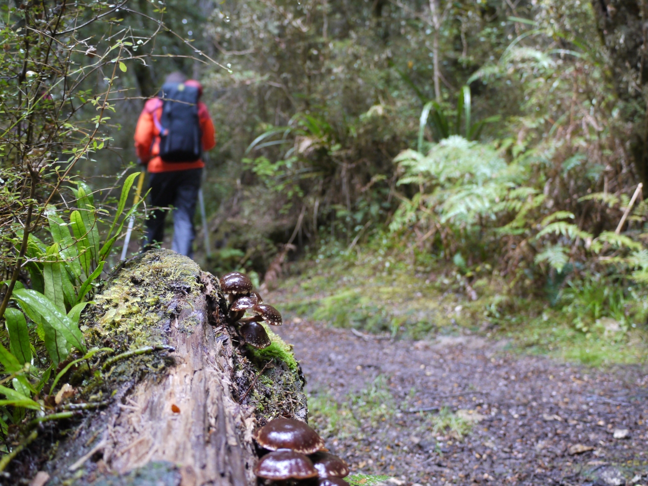
And Fergus was right: the Catlins in the wet, is the Catlins at its best. It’s not called the Catlins Coastal Rainforest Park without reason – it rains, drizzles really, around 150 days a year. After crossing the first of four swingbridges over the Catlins River, I left behind pine plantation and entered the southern-most beech forest in New Zealand. The drizzle-coated trees, their tops disappearing into the mist, seemed to take on a sharper, fresher quality than they do in the dry. Mosses hung from the trunks like spittle-coated beards and fungi of all shapes and sizes glistened like polished stones.
My promise to slow down had me noticing my surroundings more. Things like those glistening mushrooms might have escaped my attention on any other day, but this day they were something I couldn’t help but stop to photograph and inspect.
I don’t know that the forest really was more alive, but I certainly felt I was.
The Catlins River Track has been around for more than 30 years. It was built by the Forest Service during the winter months as a way to keep its workers busy. Owaka Ranger Chris Bennett arrived on the scene in 1980 just in time to help build the final two swingbridges. Even back then, attracting visitors was the goal. “It’s a really nice wee walk so the Forest Service decided it would open [the forest] up for tourism,” says Bennett.
Bennett says extending the river track into a circuit is good thing, too: “Anything where people can go and stay the night at either end [of a track] and then tramp right round is good for the area.”
For the most part, the track sticks to the river. At times it resembles a tramping route; narrow and rough, while at others it’s a broad easily negotiable track. There’s something here for everyone: challenge aplenty, but nothing too difficult as to be off-putting. On the occasions the track moves away from the river, it’s to climb steeply inland for a ways, before dropping back down to a swingbridge or another riverside meander. If you’re lucky you’ll spot yellowheads, though you’re best to take a guide like Fergus Sutherland if that’s your main objective. Despite plenty of trapping operations, the birds remain rare and elusive. Sutherland runs his eco-tours in the forest and knows exactly where to look. I did hear bellbirds, tui and kereru and spotted several pairs of paradise duck and plenty of friendly fantails which were more than happy to come within an arm’s length. I misidentified tomtits as South Island robins, which haven’t been seen in these parts for decades. Later, while having dinner with Fergus and his wife Mary I gave them reason to doubt my super tramper credentials after enthusiastically insisting I had seen the rare South Island variety of robin.
I had been on the track for about an hour and a half when I stopped for lunch at Wallis Stream and boiled a cup of tea using water gathered from the Catlins River. I found a log overlooking a bend in the river and gazed at its slowly moving majesty. With native birds chirping in the background and surrounded by native bush with hot tea warming my hands and stomach I became hypnotised by the beauty of my surroundings. Even for a so-called super tramper the opportunities to just sit, listen and take in nature are not that common. It took a sudden heavy downpour and chilly wind to rouse me from my trance and move on.
I realised I’d achieved my goal of slowing down when a DOC sign indicating times to the track end car parks revealed I was 45-minutes behind where I expected to be. I reluctantly picked up the pace, but still couldn’t help but notice the amazing bush the track passes through. Every now and then I came across a fallen tree, its trunk coated in mosses, gnarly branches twisted and rotten. Clambering over these behemoths, and watching my step on the root-addled ascents high above the river, emphasised the quality of this walk; it has a sense of adventure and wildness about it. That’s what I hope to take away from all my tramps.
I know I’m nearing Tawanui and the end of the 12km Catlins River section when the true right of the river suddenly opens up and becomes farmland. The river that provided water for my tea takes on a different quality here. White foam collects in places and rather than flowing clean and clear it takes on a tannin-stained look. There are no more paradise ducks squawking at my approach, either. I found myself wishing the forest could continue forever.

I popped out of the beech and into the large grassed area that makes up Tawanui campground. The Sutherlands eco-sanctuary is a further three-kilometres down the road, but it’s worth the extra toil to avoid camping in the wet on my own.
Over dinner, Fergus tells me more about how – and why – the loop got built. “We want more people to come and spend time in the Catlins,” he explains. Those that have done the Catlins River Walk would often have a car at either end, swapping keys with their mates as they pass on the track. “It was too tough to go there and back in one day,” he says. “So it’s been underutilised.”
Fergus was the main driver of the loop, even though he and Mary plan to sell Mohua Park and may not benefit from the expected increased visitor numbers. He arranged permission for trampers to access the private forestry land the walk passes through on the second day. He also organised a four-day working bee, getting local deer hunters, Otago Tramping and Mountaineering Club members, school groups, Scouts and Rotary members among others to cut a 900m-long track to Rocky Knoll.
It’s no surprise he’s provided the steam to get the project completed. The Sutherlands have been running eco tours in the region for more than 22 years and Fergus has a huge amount of experience in the conservation field. He’s been chairman of the Otago Conservation Board and created the DOC-run Conservation Volunteers Southland 25 years ago after seeing the potential for such a scheme while on a three-month stint volunteering in the UK. They have put a National Trust covenant on Mohua Park, protecting forever the 120 species of native plants and trees growing there.
Fergus says the loop track is a great asset for the region, offering a “varied two day tramp which provides opportunities to enjoy New Zealand’s southern-most beech forest, with river views, rare birds, mossy glades; as well as a sub-alpine area featuring one of the best and highest viewpoints in the Catlins.”
He has high hopes for the track – he wants that oringially proposed multiday walk into the interior of the forest built.
“We are anticipating that the Catlins River-Wisp Loop will help build demand,” he tells me.
The second day of the walk is a huge contrast to the first. The track links up several forestry roads and if you’re walking at speed – and unlike the first day there’s no reason not to – you can knock off the 12km walk in three hours. It’s a shame, because I quite enjoy walking through pine forests; I like their openness, the aroma and the soft feel of pine needles underfoot. But the walk is exclusively along roads where it would be much better set a few metres into the pine trees. Its hard to criticise though – Fergus and the others have done their best with limited resources. DOC advised on the Rocky Knoll extension, but wouldn’t have built it if Fergus hadn’t gathered his army of volunteers. “Unfortunately the last four or five years DOC has been a no growth environment so the ability to develop new tracks and extend the network haven’t been there,” confirms Wheeler, who left the Catlins 12 months ago.
But there is a highlight on the second day that makes it worth your while: the side trip to Rocky Knoll. It’s a 40-minute return walk to the high point and a lookout that on fine days provides what Fergus assures me are the best views in the area. Leaving the forestry road and entering the bush is like moving from a quiet room into a sound-proofed music studio and shutting the door behind you. The track softens under foot and birdsong starts up immediately. It’s just like being back on the Catlins River section.
I climbed the rough track to the high point but low cloud and cold winds scuppered the views and forced me to retreat to a viewpoint lower down the track. I pulled out my sandwiches, boiled up a brew and thought back on my three days in the Catlins.
On my first day I’d picked up a hitchhiker on my way to Cathedral Caves – a young marine biologist from America who had been in New Zealand since December and told me he had only spent $400 in all that time. He lived off rice, large bags of scroggin and the charity of strangers who would put him up for the odd night when he wasn’t camping in roadside rest areas. He was good company and reminded me of my younger days when I lived a similar hobo lifestyle hitchhiking through Alaska and travelling Europe on a shoestring.
But I realised he, and all those others who race from one roadside attraction to another, venturing only a few minute’s stroll from their car, were missing out on something you only get by slowing down and pausing to make a cup of tea. It’s the pleasure that comes from noticing the forest for the trees. It’s a feeling of being alive.
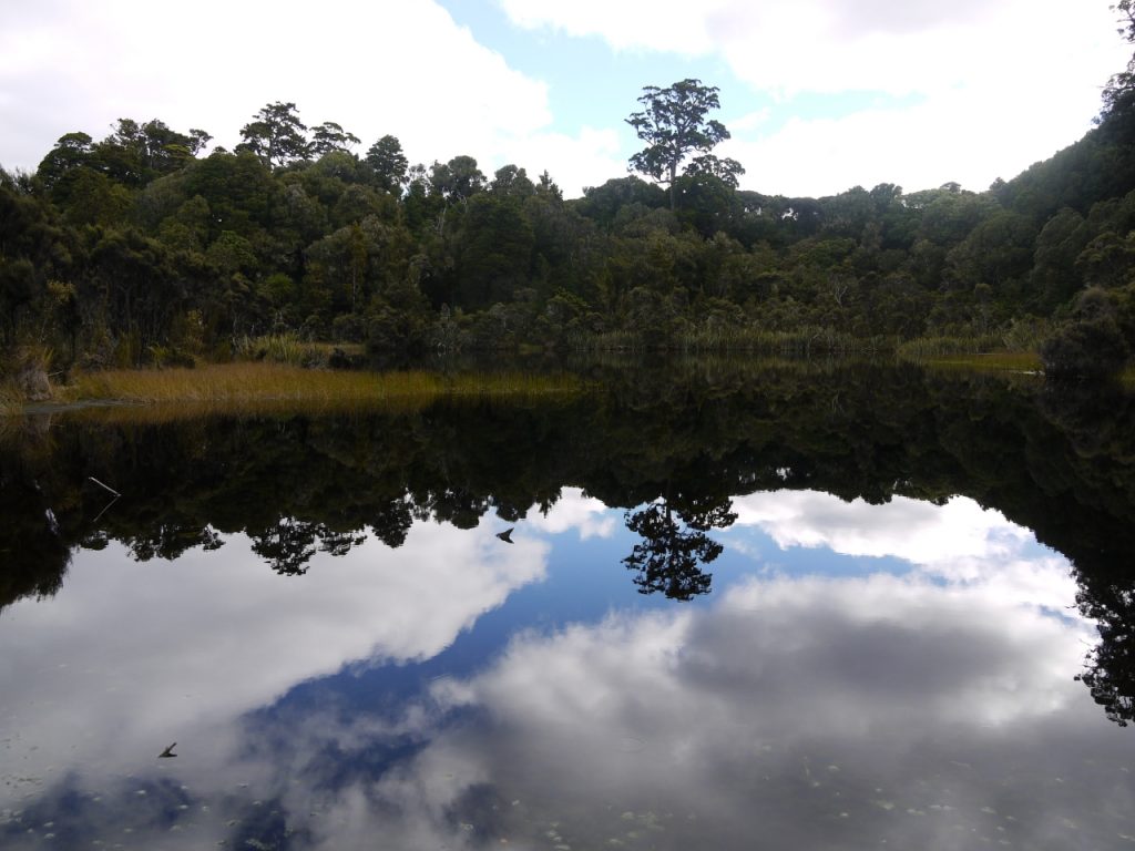
20min – A good place to experience old-growth mixed podocarp forest. The 20 minute walk from the road takes you to a boardwalk at the edge of a small, tranquil lake. Forest birds, rimu and rata trees are features.
30-45min. $5 entry fee – It seems a bit strange to pay to access a beach, but the fee is to help pay for maintenance to the 2km gravel road that runs from the highway to the car park. The track descends through native bush to Waipati Beach where a massive ‘cathedral’ has been carved into the cliff by the surf. The caves can only be accessed an hour each side of low tide.
2min – Visit at dusk (around 4pm-6.30pm in winter) to watch yellow eyed penguins waddle out of the sea after a day searching for food. The birds hop along the stony shore beneath the viewing hide to their burrows in the cliff.
30-40min – An easy benched track leads to the biggest – and best – falls in the Catlins. The track descends to Duckaday Creek and then climbs in the series of steps and switchbacks to the falls. Spectacular.
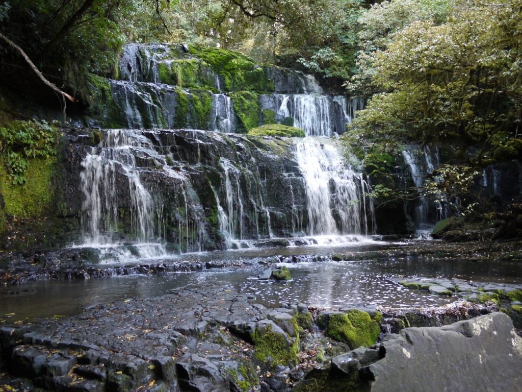
20min – A short walk on an excellent track to the best known of the Catlins’ waterfalls, located in a small reserve of mixed podocarp and beech forest.