
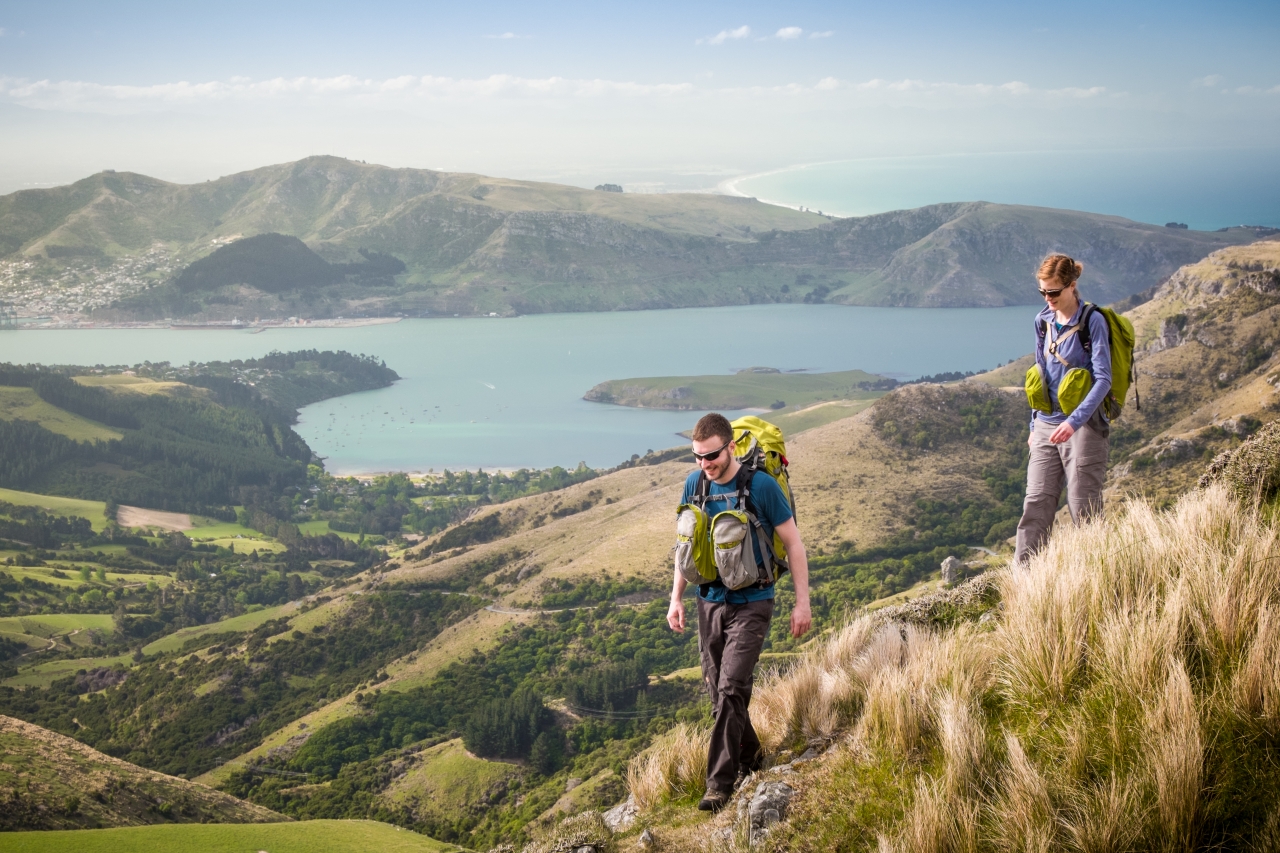
It’s mid-October, just after lambing season, when Andy Thompson and I pull into a gravel car park at Gebbies Pass. We’re within an hour’s drive of Christchurch and soon we’re walking, pine needles underfoot. Our conversation flows amid an orchestra of bleating lambs
I first heard about the ‘Spine of the Lizard’ project last February via an online video (the name has since changed to Te Ara Pataka/Summit Walkway). Suky Thompson, the manager of the Rod Donald Banks Peninsula Trust and no relation to Andy, gave a presentation about it at an earthquake recovery meeting in Christchurch. From my office-bound vantage, the idea of walking the length of a lizard, from Gebbies Pass to the Hilltop Tavern, right on my city’s doorstep, seemed appealing. So in late October, I embarked on an overnighter with a stranger. Andy is DOC’s acting recreation manager and seemed pretty friendly on the phone. Fortunately, he’s just as friendly in person.
While there’s no shortage of backcountry huts in Canterbury (there are 190 within a couple of hours of Christchurch), the region lacks frontcountry options for less experienced trampers. Lincoln University researchers say Banks Peninsula is not currently a ‘high-frequency outdoor recreation destination’ for youth organisations, relative to some other locations, but many would like to use it more. The closest alternative multiday introductory tramping experience is Mt Somers, about 1.5 hours’ drive from Christchurch.
The Summit Walkway follows a ridgeline from the Lyttelton crater to the Akaroa crater, over Mt Herbert – the highest point on the peninsula at 919m. It’s a reasonably easy two day track that can also be done in three. Several feeder tracks link to it from places such as Diamond Harbour, Kaituna Valley and Orton Bradley Park. One of the walkway’s key features, a new hut, opened to the public just days before our trip. With nine bunks, a potbelly stove and macrocarpa tables, Rod Donald Hut at Waipuna Saddle provides a halfway point between the existing Sign of the Packhorse Hut (also nine bunks) and the Hilltop Tavern. Originally a private cabin, it was purchased by the Rod Donald Banks Peninsula Trust in 2014, along with 10ha of QEII-covenanted land.

The Rod Donald Banks Peninsula Trust was established in 2010 with $3.4million from the sale of endowment properties owned by the disestablished Banks Peninsula District Council. The trust works on a range of projects to foster public access, support biodiversity restoration and improve knowledge of the area. Suky says Rod Donald, who served as a Green MP from 1996 until his death in 2005, had a deep love for his constituency of Banks Peninsula. The eponymous hut looks over Little River, where Rod is buried.
From Gebbies Pass, it takes Andy and I a couple of hours through pine forest and open country to get to Packhorse Hut, an old stone building with a bright red roof and window frames. Closed for a couple of months over winter for earthquake repairs, it boasts a new ceiling, extra bracing and a strengthened fireplace. Inside, day walkers are eating their lunch and we do the same. A sweaty mountain biker bursts in to catch his breath before hooning back the way he came.
Unlike DOC’s Great Walks, the Summit Walkway probably won’t be all that relevant to the tourism market. The aim is for it to be a gateway trip for inexperienced trampers from around Canterbury, particularly younger people. The hope is that it will draw them into a whole new world of outdoor recreation and conservation. Andy will be happy if the huts along the Summit Walkway each attract 1000 bed nights a year within two or three years.
The route from Gebbies Pass to the Hilltop Tavern intersects eight DOC reserves, Christchurch City Council land and private farmland and has actually always been there. Until now, it has been poorly publicised, sign posted and serviced. In recent times, some sections were overgrown and impassable. One such section is behind Mt Bradley, which Andy and I sidle around to get to the Mt Herbert Shelter. The track was cleared by a local contractor, and DOC has a further $65,000 to spend on track work, stiles and trail markers.
The wind is so cold at the summit of Mt Herbert it hurts my teeth, but the 360-degree views are worth it. It’s also educational. Look one way and you see gorse, stock and fence lines. Another, regenerating bush. While Maori settlement caused some changes in the vegetation of the peninsula, ‘it was not nearly as abrupt or catastrophic as the impact of European settlement’, says Christchurch botanist and Hinewai Reserve manager Hugh Wilson, in The Natural History of Canterbury. ‘Pakeha colonists arrived to a landscape still largely covered in forest and immediately set about its removal.’
The grassy ridgeline below Mt Herbert, towards Port Levy Saddle, is like white gold in the afternoon sun and gives views back towards Mt Evans, Lyttelton Harbour, Godley Head and Pegasus Bay, with the Kaikoura Ranges in the distance. Soon, Andy and I reach a large totara graveyard, which continues to tell the story of deforestation on Banks Peninsula. Early European settlers felled these once-majestic trees for timber and burnt them (some burn-offs got out of hand and raged for days) or let them waste to make way for pasture. Some trunks still bear charcoal stains.

At Port Levy Saddle, the track crosses a road and continues through Bob and Carol Webster’s land, before dipping down to Rod Donald Hut, where Suky has gin and tonic at the ready. Bob and Carol turn up soon after, having driven over from Christchurch for a chat. They bought the land adjacent to the trust’s in 2012 and are allowing the bush to regenerate. Some of the trees on their land are hundreds of years old, spared by settlers. “We could not believe our luck when we saw the ‘For Sale’ sign on it,” Bob says. “It has changed our lives really because ever since we bought it our focus is over here.”
Bob, who works in high country tenure review, became a trustee of the Rod Donald Banks Peninsula Trust in 2013 and is helping guide its work with other landowners along the Summit Walkway to formalise handshake agreements regarding public access. A keen runner, he and Carol, a botanist, spend most weekends on their land, fixing fences, chasing sheep and doing gorse control. Bob says they are pleased to see an opportunity for more people to visit the area. “We love to see people up here.”
Later that night, as Bob and Carol prepare to head back to Christchurch, Suky tells a story about the time she and her husband walked from their home in Robinsons Bay to a friend’s house in Governors Bay for Christmas. It was 1994 and they received a boisterous welcome on Christmas Eve, just in time for dinner. Parts of their three-day hike along the tops of Banks Peninsula were well-known among local trampers, including sections around Packhorse Hut and Diamond Harbour to Mt Herbert. But as for the rest of their Christmas route, not so. “We thought, ‘Why is it not being used? Why is it not known? It needs another hut’.” Twenty years later, Suky, by this time working for the trust to improve the Summit Walkway, saw a 10ha property with a hut already on it advertised in the Akaroa Mail. “We didn’t offer the highest price,” she says. But vendors Paul and Ruth Maurice liked what the trust was doing.
The Maurices bought the land soon after emigrating to New Zealand from England in 2004 and one of the first things they did was contact the Queen Elizabeth II National Trust, which helped them covenant it. Selling the property was a difficult decision “because we loved it so much … but we were not probably using it enough to justify keeping it”, Paul says. “We were just so thrilled that the trust came up as a purchaser. I rang Suky, we had a lovely conversation … and it all went from there.” The hut has still got “the original lovely feel it had when we had it, but they have absolutely enhanced it”.

The next day, I slog back up to the ridgeline through a path cut through thick gorse. While an “appalling” weed of pastoral farming, gorse is “ironically, a very useful, soil-enriching, fast-growing shelter for regenerating native forest”, Hugh says. Within 30 minutes, Andy and I are wandering among more sculptural totara skeletons with our packs off. Trunks and branches appear bleached by the sun, like animal bones. Andy, who has worked in Namibia and Botswana, says they remind him of elephant graveyards.We cruise around the side of Mt Fitzgerald and find a sunny, grassy spot for lunch at the beginning of Mt Sinclair Scenic Reserve. From there it’s up and over Mt Sinclair and through daisy meadows with views of Lake Forsyth to Montgomery Park Scenic Reserve, in sight of Akaroa Harbour. On the way down to the Hilltop Tavern, with the promise of a cold beer or lemon, lime bitters (if you’re Andy – driving a DOC vehicle), we come across a giant totara, standing tall, perhaps like its friends, had they been left to grow.
While the Summit Walkway is not the most spellbinding of trips (we’re spoilt in this country), I can see its immense potential. It’s right there, less than an hours’ drive from a major city, and a great way to get one’s bearings on the tops. Suky says there’s value in experiencing a “working” landscape and I agree. “Over the last 30 years or so there has been such a demographic shift in New Zealand. Everyone used to have a relative in the country but now there’s this sort of urban/rural divide,” she says.
The DOC online booking system means you can easily book the charming Rod Donald Hut out among friends for a celebration or even just a simple overnight getaway. You can basically drive to it (park at Port Levy Saddle, walk less than an hour), or use public transport – a bus to Lyttelton and a ferry to Diamond Harbour. It’s exposed to cold winds, presenting a good opportunity to educate inexperienced trampers on the need to prepare for the elements, and the days are long enough to be a challenge for new trampers, youngsters and experienced but unfit trampers (ahem). Packhorse Hut has also been put on the DOC booking system to make it easier for families to use.
Suky has lived near Akaroa since 1991 and is a tireless advocate for Banks Peninsula. As well as a job, the Summit Walkway has clearly been a passion project. In October, more than 20 years after that Christmas hike with her husband, and a day before the booking system went live on the DOC website, she had the joy of unlocking Rod Donald Hut. It was “a pretty thrilling moment”, she says. “Having a second hut was key to making the whole thing work.”


