
The wispy mist clung to the grass, to the tin hut, to the grooves of the mountains that towered around us. It gently floated as the rising sun seared holes through it. I was confident the sun would succeed. It had to. Because today was an important day. Stag Saddle, in the Two Thumb Range, beckoned, followed by a ridgeline rumoured to have sublime views across Lake Tekapo. Today I would get my first glimpse of Aoraki/Mt Cook.
But, it was cold. Gloves and leggings cold – colder than it should be for a morning in late February. But then, we were about 1400m above sea level, in a hut reputedly visited by Prince Charles and Princess Anne as children – by all accounts, it’s how Royal Hut got its name. We stood at one of the small, grimy windows, looking out at the curling mist, willing it to evaporate whilst rubbing our hands together.
The excitement was palpable. A motley crew of Southbound Te Araroa walkers about to embark towards the highest point on the trail. Stag Saddle. A lofty 1925m. And then a glimpse of New Zealand’s tallest mountain from a ridgeline. We just had to be able to see where we were going.
And that was definitely proving a problem. The sun was losing. Mist had been replaced by thick, claggy cloud. Visibility was 10-metres at best.
“Should we leave later?” a girl from Belgium asked. We waited. Impatiently.
As the minutes ticked by, the cloud swam until, poof, it lifted entirely in a sparkling reveal. The valley of yellow tussock glowed and the sky rang clear blue. Off to the west, the scree-clad cliffs beckoned. It was time to go.
“I’m so excited, I just can’t hide it, I’m about to lose control and I think I like it.” I sang at the top of my voice as I strode along the trail, slowly warmed by the sun and the pumping of my blood. Within an hour, gloves and leggings had been peeled off and I was sweating profusely.
Friends who had already walked the track had described it as an easy gradient and had clearly bounded to the saddle like the Himalayan tahr that roam the Two Thumb Range. But for me, it seemed more uphill than easy gradient; more like walking through tar at times than bounding like a tahr. The waist-high tussock whipped at my now bare legs as we jumped back and forth across a stream towards the saddle. Thankfully, our feet didn’t get wet.
It had taken two days to get to Royal Hut. We’d left Geraldine on a shuttle bus and marched into the Two Thumb Range and Te Kahui Kaupeka Conservation Park towards Crooked Spur Hut after a day of torrential rain. It left a heavy dusting of snow on the mountains and there was some concern Bush Stream, which we would have to crisscross nearly 30 times, would be flooded. Four walkers took the cautious option, instead entering the park early along the Forest Creek track to Bullock Bow Saddle to re-join the Te Araroa Trail just before Royal Hut. The rest of us took our chances with Bush Stream.
The water flowed fast and cold as we crossed and boulder hopped and crossed again, working our way up the gorge. The bottom of my shorts got a slight dousing where the water was more furious but the river stayed crossable. A steep climb was left for the end of the day; a painful hour-long and heart-palpitating zigzag to Crooked Spur Hut. The view was worth it – Bush Stream carved its way through the grey mountains and in the distance, a blue slash of the Rangitata River.
The second day took us west of Crooked Spur and up to a saddle where the mountains rolled like giant waves in a sea of rock and scree. For hours we walked through tussock, some of it waist-high, and then re-joined Bush Stream, plodding beside it through the heat past Stone Hut and onto Royal Hut.
Trudging on towards Stag Saddle, I glanced back at the cleft of the river valley we had been following before breaking into higher, open ground. Royal Hut was invisible amongst the expanse of softly moulded hills. This vast vista supposedly inspired Samuel Butler’s fantastical satire book Erewhon – ‘nowhere’ spelt backwards. A small dot in this wide glorious space, I certainly felt in the middle of nowhere.
After three hours of climbing, we finally reached Stag Saddle. Despite its height, the saddle was surprisingly nondescript – a mass of scree and rocks cascading down towards the valleys. To the left, the land rose and folded in a wall of scree; to the right, the 2070m high Beuzenberg Peak loomed dark and pointy, linking a gentle camel’s back ridgeline into the distance. And dipping down in front of us, the Te Araroa Trail descended to the tussock-covered Camp Stream Valley. The ridges obscured any wider view. I was standing at the TA’s highest point, yet I couldn’t help but think: is that it?
But the sky was blue and the puffs of cloud were hardly troublesome. It was a no-brainer then to climb to the ridgeline rather than take the Te Araroa Trail down. The ridgeline was, after all, recommended.
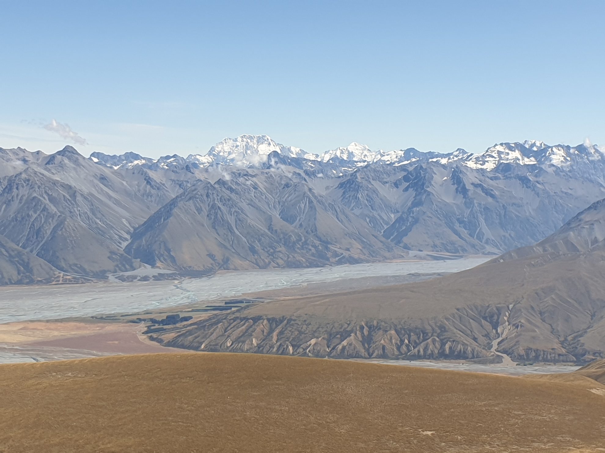
A traverse across the scree slope took us to the ridge (unnamed on maps but known as Snake Ridge) beneath Beuzenberg Peak where suddenly I felt I was standing at the top of the world rather than the bottom of a sandpit. I could see down into Camp Stream Valley on my left where scree mixed with tussock and the stream carved its way into the distance. But it was the view to the right, which caught me. This was what I’d spent two and a bit days walking for. Here, the Macaulay River met the Godley River in a maze of braids, giving space to unimpeded views of jagged mountains. The chiselled cones jutting skyward from the riverbed like shark’s teeth.
Cloud bubbled and bounced from one grey peak to the next before revealing the crowning glory – Aoraki/Mt Cook. You couldn’t mistake it. It stood proud and formidable, towering above its grey fortress like a giant shard of glass. It looked menacing, hard, but there was something mesmerising about it. It was simply beautiful.
I stared at the mountain for a long time as wisps of cloud floated past its iced east face. Slowly we turned and wandered down the wide, safe ridgeline; an undemanding trail (certainly by TA standards) with the slightest of declining gradients. A joy to walk, I positively skipped. Then stopped to gaze. Each step was a new angle from which to admire Aoraki’s summit. Each step took us closer to where the river braids emptied into the milky turquoise basin of Lake Tekapo, which shimmered in the distance.
We stopped for a late lunch, away from what looked like day-trippers who had entered from Lilybank Road. The rocky ground had been warmed by the sun. Aoraki ever present as we ate cheese wraps and boiled water for tea. Then we sat back with sublime smiles on our faces, toasted the ‘Cloud Piercer’ with our cups of tea and feasted some more on the mountain views.
34 years of inspiring New Zealanders to explore the outdoors. Don’t miss out — subscribe today.

Questions? Contact us


