
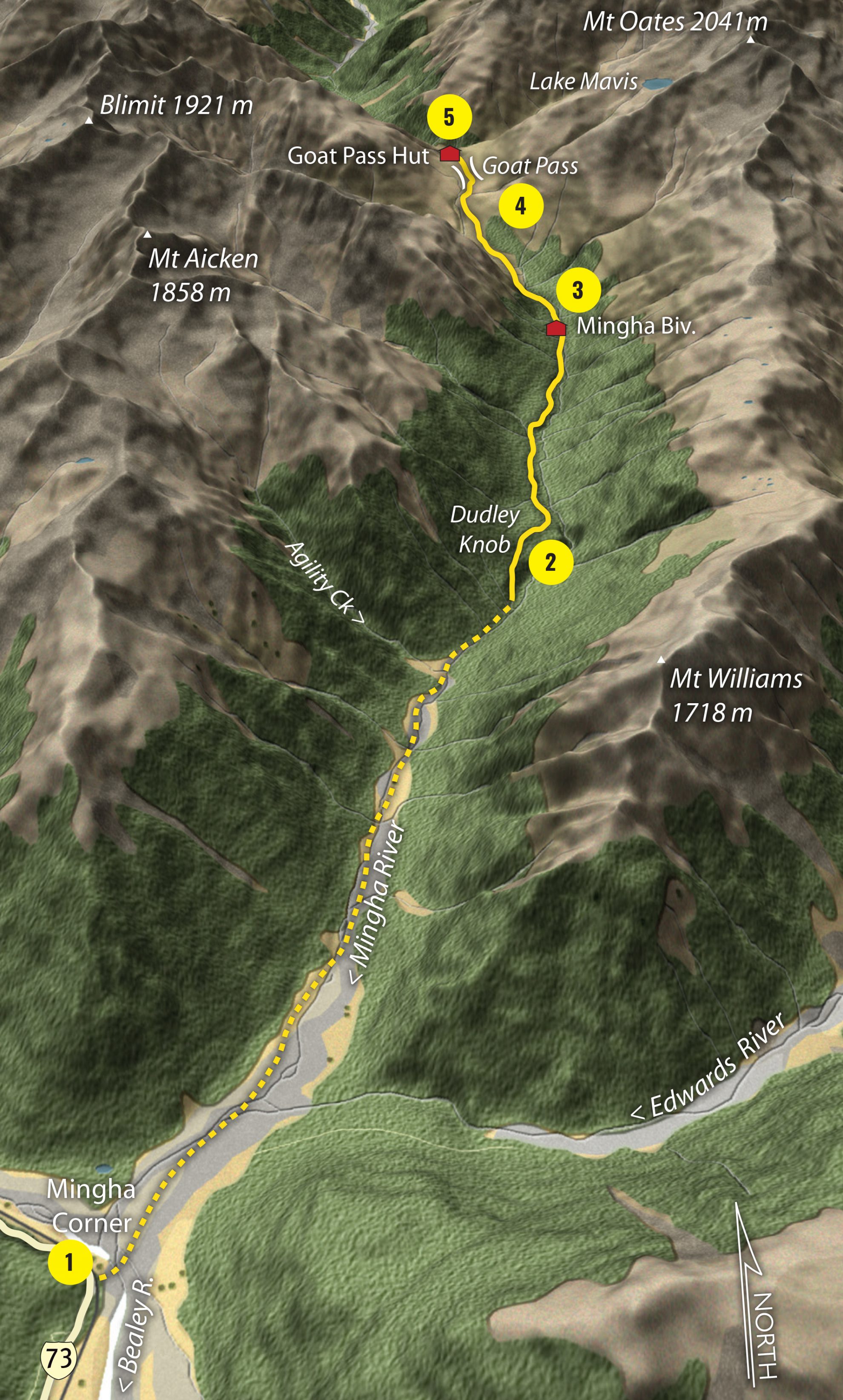
1. Mingha Corner
The usual southern starting point for the track, but beware: it’s straight into the Bealey River, and it’s usually cold! Make sure you’re not starting here after or during heavy rain as there’s no bridge and the river will be too dangerous to ford. There’s no real track to start with, just up the riverbed.
2. Dudley Knob
About halfway to Goat Pass, Dudley Knob, with its low scrubby vegetation, above the Mingha Gorge is a good rest stop and viewpoint into the upper valley.
3. Mingha Bivouac
An historic and usable bivy sited beside the Mingha above the gorge. It has a peaceful setting and blue duck are sometimes seen near here in the river. Kennedy Falls, plunging 150m out of an alpine basin, is just upriver from the bivvy.
4. Goat Pass
The northern side is a bit of a goat-track where it drops steeply into the Deception. However, the southern approach is much easier and crosses the pass on numerous boardwalks. There’s also grand views of the Southern Alps and the alpine vegetation is magnificent.
5. Goat Pass Hut
This large hut sits just over the pass and is reasonably well protected from the storms which lash this area at any time of year. It has great views into the Deception Valley and it is a staging point for officials during the Coast to Coast event.
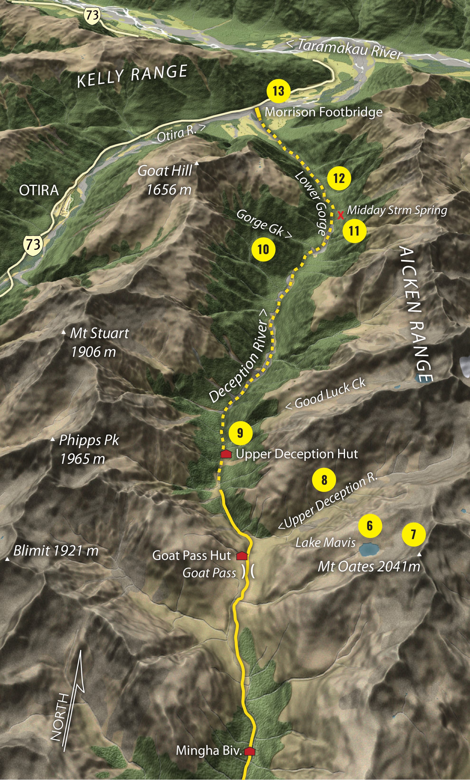
6. Lake Mavis
This exquisite alpine lake lies just above Goat Pass and will take around two hours to reach. It is set in a post glacial cirque at 1600m beneath Mt Oates.
7. Mt Oates
Mt Oates, 2041m, is accessible from Lake Mavis but only for those with climbing and route-finding skills. The usual route lies to the south, from the basin above Kennedy Falls, and up a steep gut to the summit.
8. Upper Deception
Wild and remote, the Upper Deception continues to the north-east above the pass. It is the approach route for ascents of Mt Franklin. Below the pass, sections of riverbed are interspersed with short sections of track and a sharp eye is required to ‘stay on track’.
9. Upper Deception Hut
Any port in a storm, Upper Deception Hut provides welcome shelter when the river is in a contrary mood or if you have misjudged the time and distance from the Morrison Footbridge to Goat Pass – it’s not called the Deception for nothing!
10. Gorge Creek
There are some large gravelly flats both above and below Gorge Creek, allowing for faster travel in the oftentimes slow and tedious passage through this valley.
11. Midday Stream Spring
You will smell it before you get there, but unfortunately it’s not hot, just a small cold spring beside the river.
12. Lower Gorge
Though not a true gorge, the Lower narrows and still deserves respect as the river is often boisterous and swift-flowing through here. Crossings need to be chosen with care.
13. Morrison Footbridge
The long, tall footbridge marks the end (or beginning) of the journey. It offers an excellent panorama of the peaks and valley from its mid-section and a perspective on how ferocious the floods here can be – just look at the stop bank beside the railway line to see how high the water comes.


