
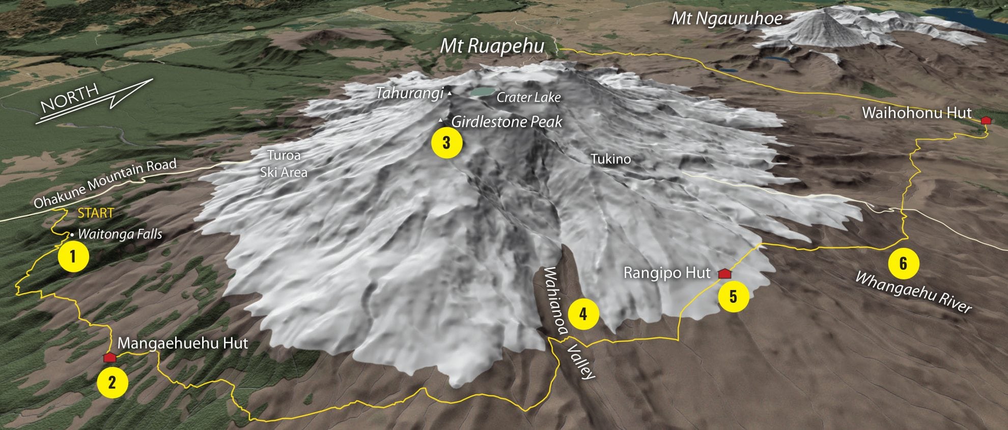
1. Waitonga Falls
From the Ohakune Mountain Road, the track climbs briefly before sidling through mountain beech forest and across the subalpine wetlands of Rotokawa. Viewed from a footbridge, the 38m Waitonga Falls plunge in a diagonal. Beyond, the track sidles eastwards, crossing several of the many streams that radiate from Ruapehu’s flanks. The last half of the day traverses above the bushline to end at Mangaehuehu Hut.
2. Mangaehuehu Hut
One of several Lockwood huts built at Tongariro during the 1960s and 1970s, Mangaehuehu Hut offers good views of Girdlestone and the southern flanks of Ruapehu.
3. Girdlestone Peak
Girdlestone is one of the most defined of Ruapehu’s several peaks and was once called the Little Matterhorn, after a passing resemblance to the more famous peak of the European Alps. In the 1920s, it was re-named after pioneering outdoorsman Hubert Girdlestone, who died from a shrapnel wound during the First World War.
4. Waihianoa Valley
The track weaves in and out of beech copses, across several streams, before bending north-east towards the Rangipo Desert. A prominent ridge at 1500m overlooks one of the mountain’s largest valleys, the Wahianoa. Littered with rocks from past eruptions, the broad valley can be a bleak, exposed place in the wrong conditions and requires a tiresome climb at the far side.
5. Rangipo Hut
Situated at nearly 1600m, Rangipo Hut is the highest on the circuit and faces east, with views over the Desert Road and Kaimanawa Ranges. It’s surrounded by the Rangipo Desert, which lies in the rain-shadow of Ruapehu. Although not strictly a desert, the combination of the altitude, harsh winters and quick-draining volcanic soils mean that any plant life here is sparse and often spindly. It’s worth exploring some of the undulating terrain, shaped by wind and frost, with artfully-strewn boulders and unlikely pockets of subalpine vegetation.
6. Whangaehu River
The track bends northward over more open terrain, following a long succession of snow poles. A footbridge spans a small gorge in the Whangaehu, a river of some historical significance. On Christmas Eve, 1953, a lahar from Crater Lake swept down here, wiping out a rail bridge and killing 151 people aboard a north-bound train. Since the Tangiwai Disaster, other lahars have swept down the valley, requiring the footbridge here to be replaced at times, notably during the 1995 eruptions. Further north, the track crosses the Tukino vehicle track, and gradually loses altitude to enter open beech forest before reaching Waihohonu Hut.
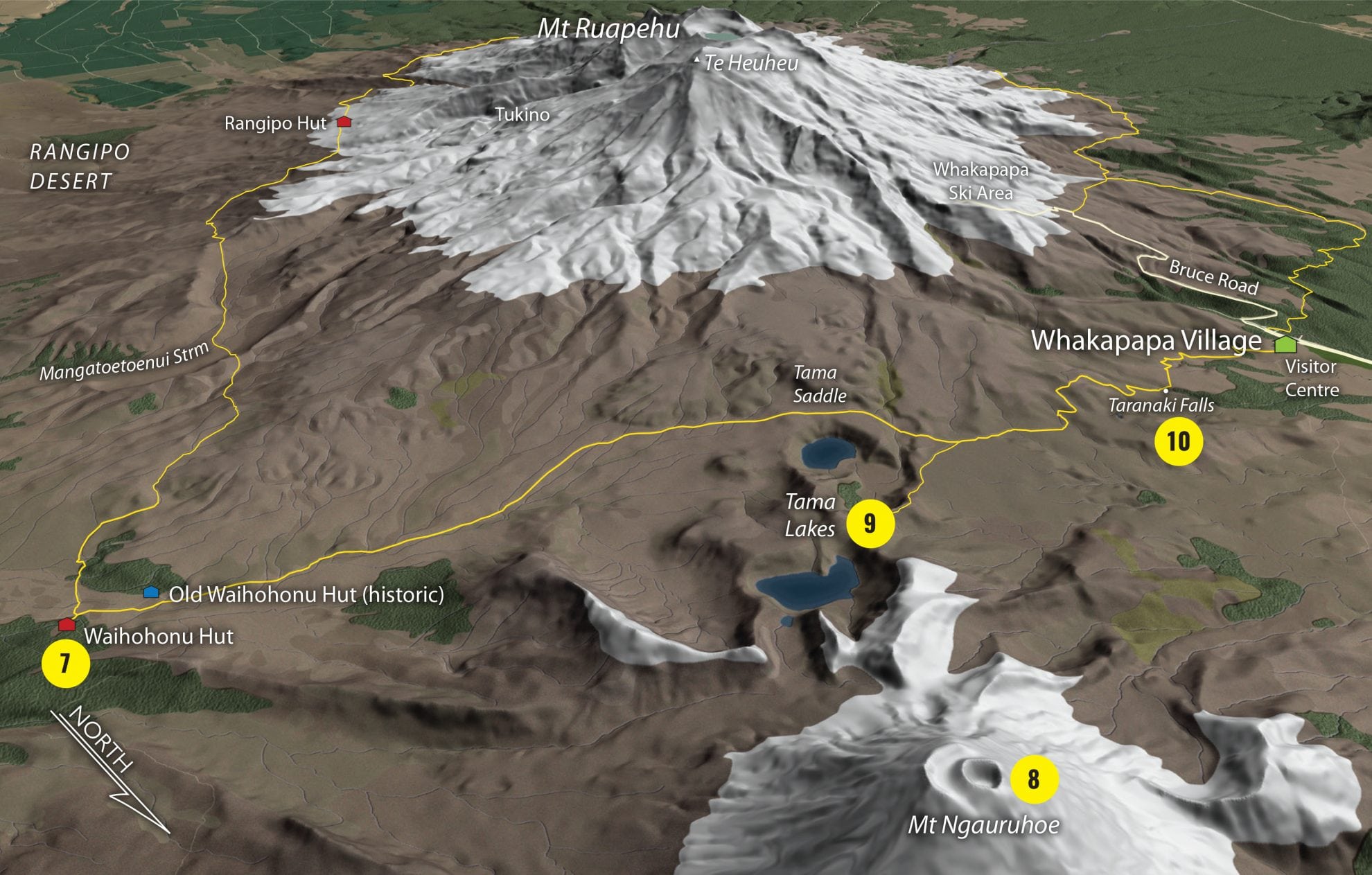
7. Waihohonu Hut
With its huge, volcano-framing windows, large bunkrooms, solar lighting and hot water, Waihohonu is both the flashest and largest hut in Tongariro. Completed in 2010, it’s the third to occupy the area. The original historic hut, now called the Old Waihohonu Hut, has been preserved, and makes an interesting diversion. Built in 1903-04, it was one of the park’s original huts, and also served as the headquarters of the Ruapehu Ski Club. The historic hut has segregated bunkrooms, insulating pumice walls and old graffiti. There’s also a camping area, down from the hut.
8. Mt Ngauruhoe
From Waihohonu Hut, the track overlaps with the Tongariro Northern Circuit and heads westwards towards Whakapapa. Poles lead up the Waihohonu Valley, soon emerging from beech forest into open landscapes once again. Mt Ngauruhoe, an almost perfect flat-topped cone, comes to dominate the view to the north, while two long ridges – Pinnacle and Waihohonu – rise to the northern ramparts of Ruapehu.
9. Tama Lakes
The large Tama Lakes occupy two old explosion craters in the saddle between Mts Ngauruhoe and Ruapehu. A clearly signposted side-track climbs a ridge to viewpoints of the lower, then upper, lake.
10. Taranaki Falls
Beyond Tama Saddle, the track descends to Taranaki Falls, a horsetail-shaped plume of water that cascades over a lava bluff. Trampers face a choice of tracks to Whakapapa: the lower track takes longer but offers more shelter in forest, while the upper track is faster but more exposed.
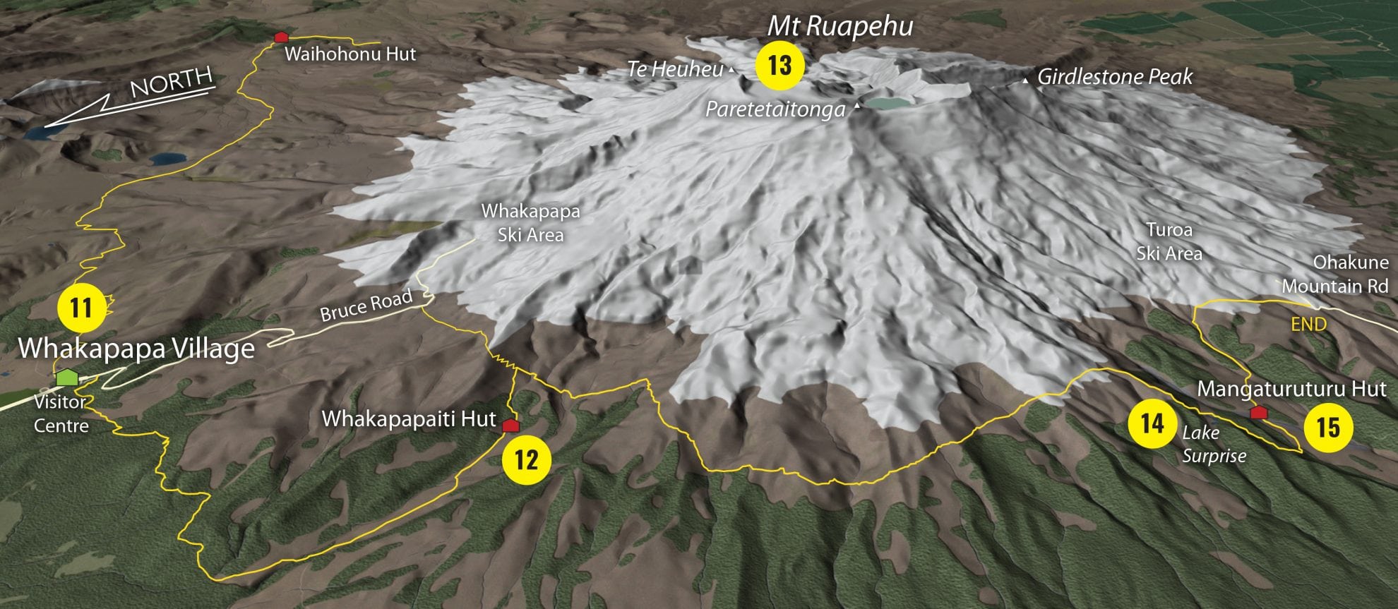
11. Whakapapa Village
For trampers needing a break, the bustling Whakapapa Village offers the chance for a coffee, a resupply, or a visit to the Tongariro National Park Visitor Centre.
12. Whakapapaiti Hut
From the village, the track enters forest, crosses the Waikare Stream on a footbridge, then sidles south-west to the banks of the Whakapapaiti Stream, where it swings south-east. The first ford of the stream is bridged, but not the second, reached about 30 minutes before Whakapapaiti Hut.
13. Mt Ruapehu
Whakapapaiti Hut offers fine views of Mt Ruapehu, showing a profile with three distinctive summits. From the hut, the route climbs briefly, then heads south. Most of the day is spent sidling across exposed rocky terrain, riven by numerous streams, and seamed with pockets of subalpine plants, notably mats of white daisy. Several of the streams feature small waterfalls tumbling over old lava flows.
14. Lake Surprise
After several hours of sidling, the track descends towards Lake Surprise, which usually isn’t too much of a revelation, unless it’s misty. This shallow lake, lying in a scoop just above the bushline, often reflects Ruapehu. Beyond, a series of boardwalks and stairs descend into the Mangaturuturu Valley.
15. Mangaturuturu Hut
In normal flow, the Mangaturuturu River is straightforward to ford, but can be difficult when flooded. A short climb leads to Mangaturuturu Hut, arguably the best-situated and most aesthetically pleasing of the tramp. It was built by members of the Wanganui Tramping Club in 1958 and exposes a fine vista of Ruapehu, while offering shelter from the surrounding forest. The final day’s tramp to Ohakune Mountain Road climbs steadily, passing the creamy-coloured cascades of a stream draining Turoa Ski Field.


