
Note: Avalanche hazard exists during winter and spring, and bridges are removed. During heavy rain the road floods, preventing vehicle access beyond Paradise.
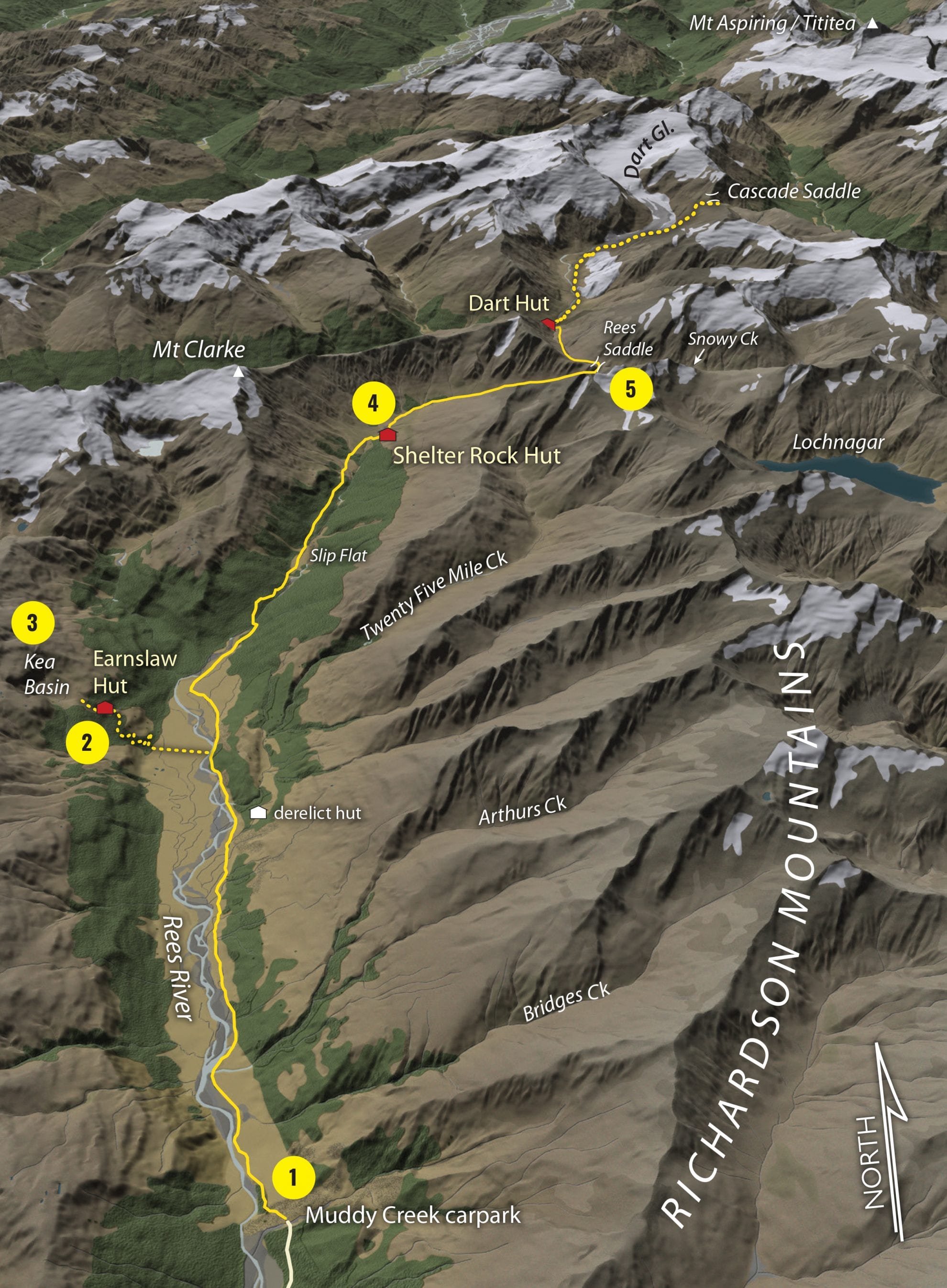
1 Muddy Creek
A 4WD road crosses leasehold land along easy river flats.
Follow marker poles across a boggy section beyond Arthurs Creek. A short grassy trail leads to the site of the old Twenty Five Mile Hut, built by the Otago Tramping and Mountaineering Club. From here, the views of Mt Earnslaw (2830m) are spectacular. Twenty Five Mile Creek is usually a trickle, but a memorial plaque to two trampers who drowned here is a reminder of the danger streams pose when in flood.
2 Earnslaw Hut
If you are a competent navigator with a sense of adventure, the steep track to Earnslaw Hut is a worthy detour.
The impressive Lennox Falls (175m), thunder through a slot in the otherwise impenetrable rock wall. The Rees River must be forded to cross private land, just north of the falls. A large orange triangle on a giant beech tree marks the steep bush track which zigzags between bluffs, topping out onto a boggy terrace before climbing to the lip of Kea Basin. A marked side-track leads to where the corrugated-iron shelter squats in the forest. Recently renovated, Earnslaw Hut still retains rustic charm. A gurgling stream provides ample water.
3 Kea Basin
About half an hour above Earnslaw Hut is a well-established rock bivouac. A windbreak of stacked rocks divides the shelter into two sleeping quarters, with separate fireplaces. Kea Basin provides a grandstand view of the colossal mountain architecture looming above. From here, an ascent of Mt Earnslaw/Pikirakatahi is possible via Esquilant Bivvy. The airy view to the 2830m summit is breathtaking, as is the view to Lochnagar (2316m) in the Richardson Mountains across the valley. Listen out for the raucous cry of kea.
4 Shelter Rock Hut
The Rees Track enters delightful beech forest where lush carpets of moss cloak each side of the benched track. A swingbridge crosses to the true right. Later, the track spits you onto an old landslide which careered off Mt Clarke, rolling car-sized cubes of granite across the plains. Wade through long grass at Slip Flat, before the trail opens out onto exposed avalanche fans. Finally, the sidle route drops to a wooden footbridge, leading directly to Shelter Rock Hut on the east bank.
5 Rees Saddle
The upper valley becomes subalpine but is still easy going. At the valley head, the route follows a poled path up to Rees Saddle (1471m). Zigzagging up the tussock, the ascent takes about 30 minutes and is not too exposed. From the saddle, you can climb to Pt2185 for a view of Lochnagar lake.
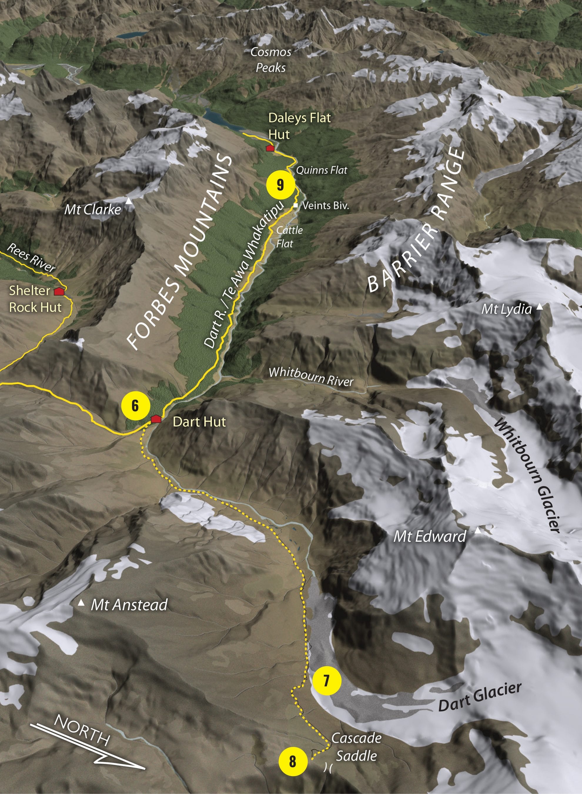
6 Dart Hut
From Rees Saddle, a rocky and narrow sidle leads above Snowy Creek. This traverse could be dangerous if wet or snow-covered. Dart Hut is nestled above the confluence of the Snowy and Dart rivers (note, the bridge over the gorge is removed during winter) and camping spots abound. Now in its third incarnation, Dart Hut was originally built in 1937 by the New Zealand Alpine Club.
7 Dart Glacier
Most parties spend a rest day at Dart Hut so they can visit Dart Glacier and Cascade Saddle. Follow the large rock cairns and poles up the desolate Dart Valley. The ground trail drops onto the level pan of moraine gravel near the terminus of the glacier.
8 Cascade Saddle
Cascade Saddle sits some 400m above the Dart Glacier and is one of those to-die-for destinations on any tramper’s itinerary. Mt Aspiring’s perfect 3033m pyramid of rock and ice towers above the Matukituki Valley, far, far below. To limit the impact on
this fragile alpine environment, camping is only permitted near Cascade Creek where there is a toilet. The trail from the Dart Valley is loosely cairned and steep.
9 Veints Biv
From Dart Hut, walls of lush green moss and ferns line the track. Not far downstream is the Pass Burn, the key to reaching O’Leary Pass, Arawata Bill’s death-defying route into South Westland.
Veints Biv is three hours from Dart Hut. The biv – a huge boulder cantilevered outward with a dry cave beneath – has room for at least 10.
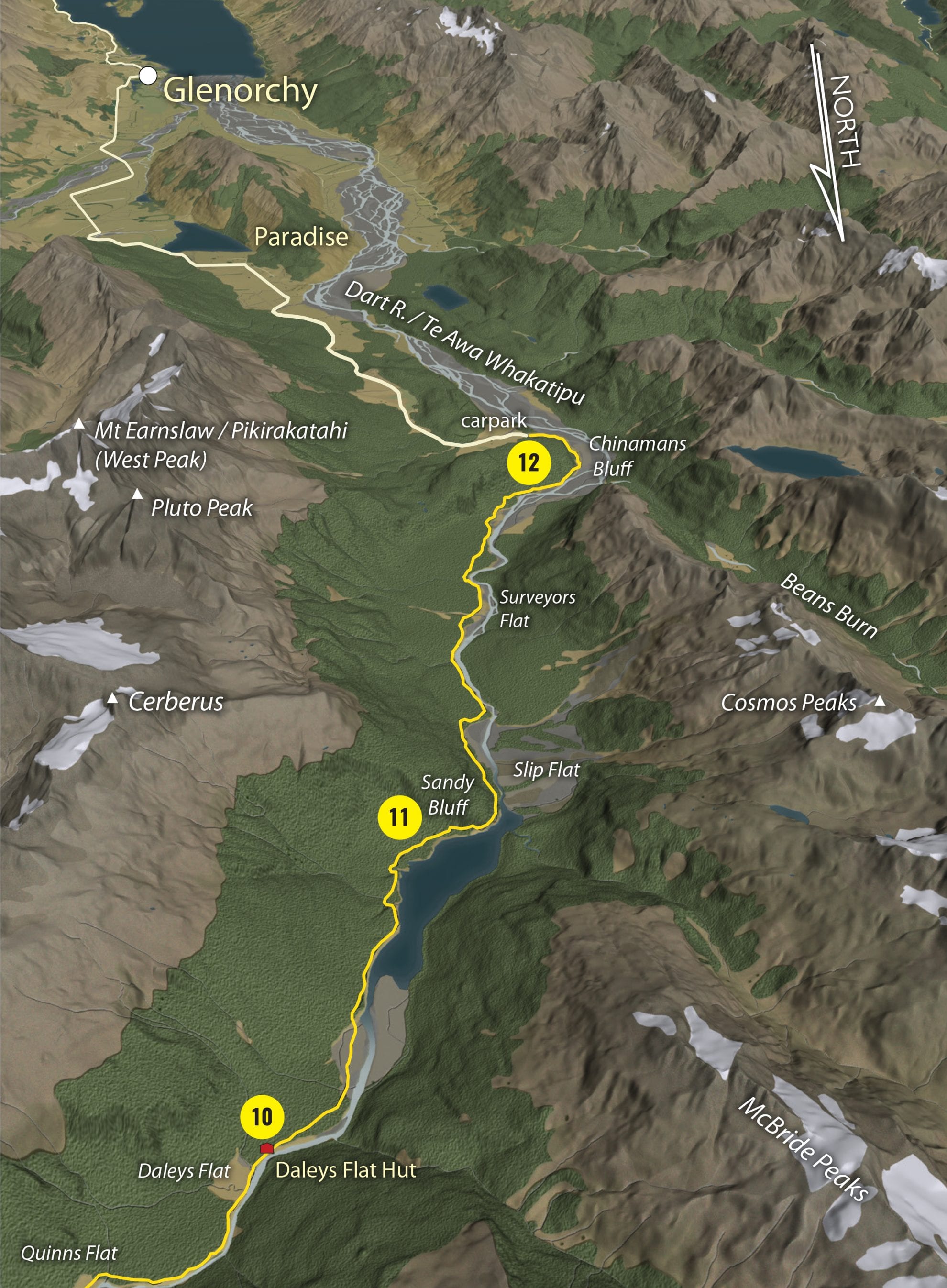
10 Daleys Flat Hut
Daleys Flat is home to an older 20-bunk hut, sporting a stunning view towards the Barrier Range, where prospector Alphonse Barrington travelled during 1863 in his search for gold.
11 Sandy Bluff
Climb high above the Dart River and the 3km-long lake formed by a massive landslide in 2014 to reach Sandy Bluff. Here, the Dart cuts under the river bank, requiring a steep 70m climb to an exposed shelf where the track was blasted from the rock face.
12 Chinaman’s Bluff trailhead
The trail ambles along a terrace above the braided Dart and then circles around Chinamans Bluff, where long-gone Chinese miners once left their supplies. The road end is not far off.


