


If you’re regularly rubbing shoulders with other trampers, you will hear it. A sort of snobbery from the elite, hardened hiker who ‘has done it all’. You will hear them ridiculing the Great Walks; that the humongous huts ruin the landscape; the prices are too high; the best tramps in Aotearoa are overrun with foreign backpackers. And, while they’ve got an axe to grind, they do have a valid point. Hardcore trampers are often forced to find real wilderness and solace in the more remote backcountry.
But is it all so ‘black and white?’ Why are our definitions of ‘front country’ and ‘backcountry’ so polarising? There must be some common ground; some show-stopping, jaw-dropping wilderness that DOC has not yet over-promoted into a trekker mecca. Tracks that feature stunning scenery, but without the price tag.
Here are nine alternatives to the Great Walks. They may be poor cousins, but they are definitely not the ugly sisters.
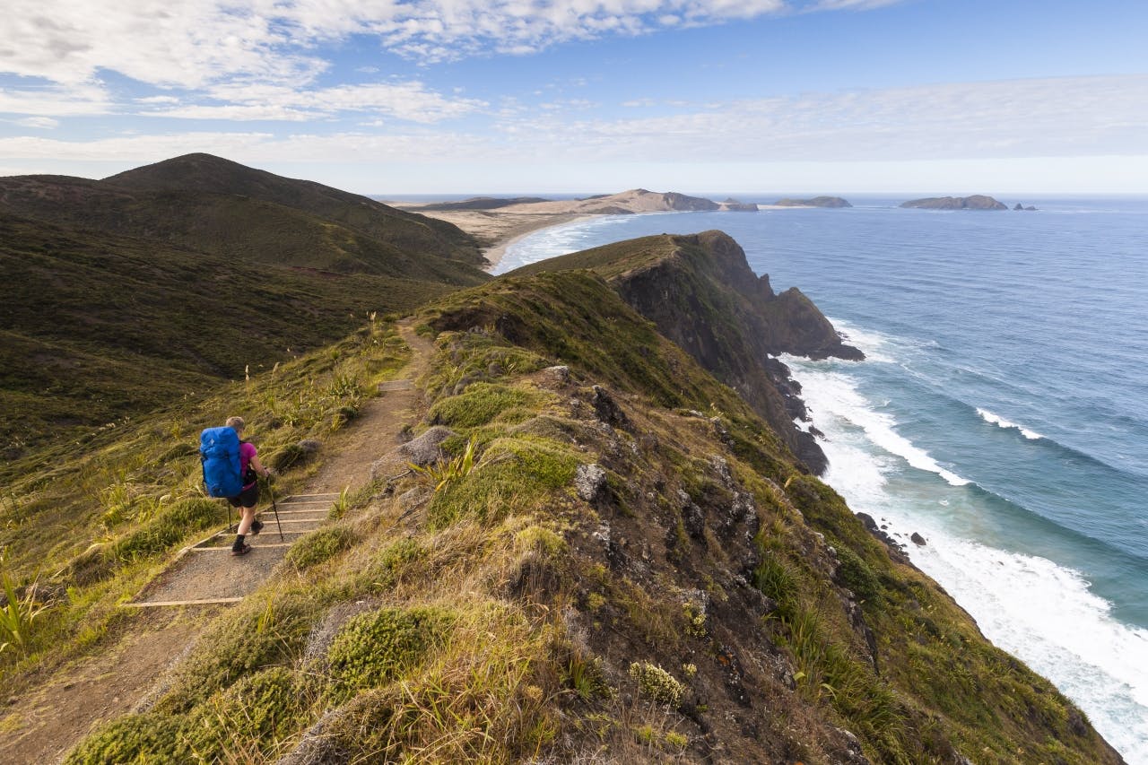
Te Paki Coastal Track
Poor cousin to: Rakiura Track
Stewart Island is infamous for its mud. On the 32km Rakiura Track, boardwalks were built to protect the fragile environment, but are somewhat monotonous. However, the coastal sections of the Great Walk exude that wild, remote vibe of being at the bottom of the world.
If you don’t wish to be that remote, a replacement is found at the opposite end of Aotearoa. The 48km Te Paki Coastal Track begins at Spirits Bay, turns south after the lighthouse at Cape Reinga, passes Cape Maria van Diemen onto idyllic beaches to finish at the northern end of Ninety Mile Beach.
It boasts a warmer climate, a rugged coastline with spectacular views, and requires the same sort of fitness level. While you must be self-sufficient (there are no DOC huts here) you’ll no doubt have company, as this is where most Te Araroa Trail walkers begin their long journey south.
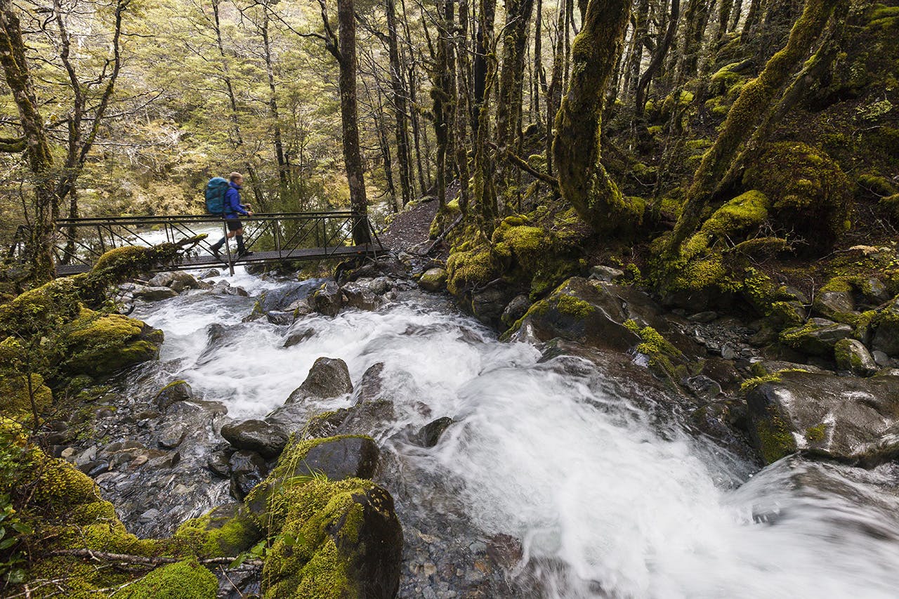
The Old Ghost Road
Poor cousin to: Heaphy Track
First up: the Heaphy Track. I walked this as a 10-year-old in gumboots – my first multi-day tramp.
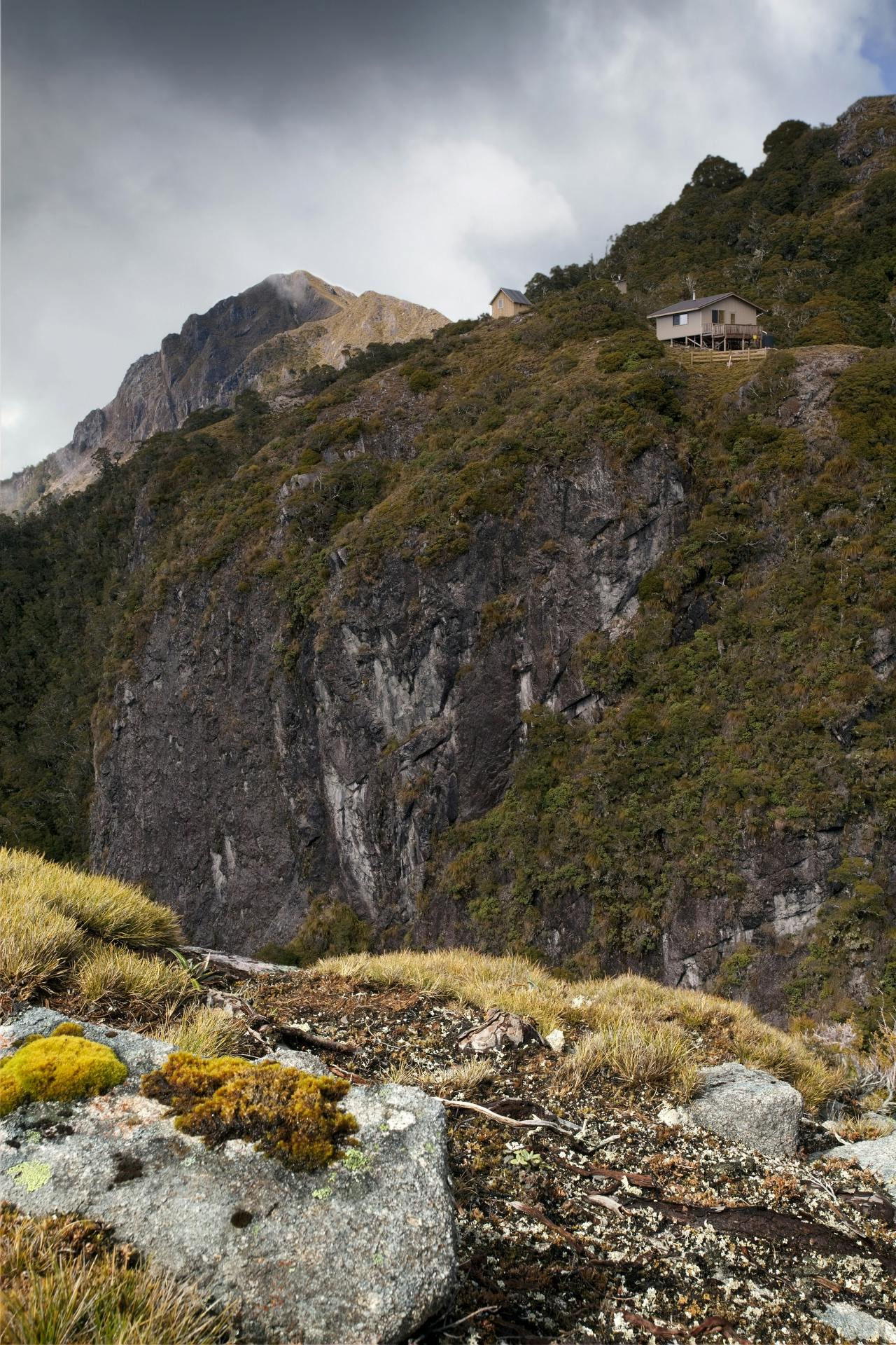
For $35 a night you can beat the crowded Heaphy and stay at Ghost Lake Hut on The Old Ghost Road. Photo: Ray Salisbury
It’s now a Great Walk, and DOC’s advertising spiel waxes eloquently: ‘Cross rivers and streams through beautiful beech forest, rolling areas of tussock and podocarp forest before emerging amongst nikau palm-fringed coastline and the roaring seas of the wild West Coast.’
The Heaphy sports nothing as breath-taking as Milford Sound or the Southern Alps; it just boasts a diverse smorgasbord of landscapes, flora and fauna, like much of Kahurangi.
The 80km track was first surveyed by James Mackay, who used it to guide a party of gold prospectors back to the Nelson district. Nowadays, it’s a gravel highway featuring expensive swing-bridges and luxurious huts, often crowded with guided parties. During winter it doubles as a mountain bike track.
Is there a cheaper alternative? Yes, there is. A mere 50km further south is The Old Ghost Road, all but finished and ready to ride. Only 6km longer than its more famous cousin, this newly built track takes trampers 4-5 days to traverse across diverse terrain featuring river valleys, open tussock tops and a spectacular gorge.
The Lyell-Mokihinui Backcountry Trust built custom-designed huts along the route, each having its own idiosyncratic quirkiness to fit the location.
While The Old Ghost Road does not feature a coastal section, it does pass through historic ghost towns and a ridge top ramble that makes the climb to get there worthwhile.
Young-Wilkin Circuit
Poor cousin to: Milford Track
What could possibly rival the Milford Track, with its world-class reputation? ‘Experience the grandeur of rugged mountain peaks, sheer canyons and majestic waterfalls. Walk beside pristine rivers and in lush rainforest before crossing the pass,’ enthuses DOC’s description.
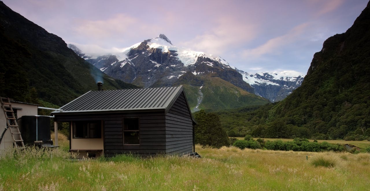
Top Forks Hut on the Young-Wilkin Circuit. Photo: Ray Salisbury
Well, that advertising spiel sounds remarkably similar to the Young-Wilkin Circuit in Mt Aspiring National Park. Swap the Real Journeys boat trip along Lake Te Anau for a jet-boat ride down the mighty Makarora River. Replace Mackinnon Pass (1069m) with Gillespie Pass (1501m). Instead of a side-trip to Sutherland Falls, try the detour to Crucible Lake, crowded with icebergs. This corner of the country is less crowded, and you don’t have to book the accommodation a year in advance. Admittedly, the route over Gillespie Pass is a more demanding circuit, but it’s nearly the same distance as ‘the finest walk in the world.’
If you’ve got enough experience, check it out.
Travers–Sabine circuit
Poor cousin to: Routeburn Track
After reading the rhetoric on the DOC website – ‘Traverse the magnificent Southern Alps of New Zealand. Walk below majestic peaks, through beautiful beech forest and above vast valleys’ – and you could be forgiven for thinking nothing could ever replace the remarkable Routeburn Track: a 32km ramble over a low saddle followed by a high traverse above big, wide valleys with stunning scenery. One problem is that of transport; returning via the Caples or Greenstone Tracks to the Glenorchy region really makes this a five-day round trip.
Tumbling rivers and gorgeous beech – must be the Routeburn, right? Nope, it’s the Travers-Sabine Circuit. Photo: Mark Watson
So, instead of booking the Routeburn and ‘doing it’, – like I did, in cold, summer rain – choose a fine weather window and walk the Travers-Sabine Circuit in Nelson Lakes National Park. This classic 80km-loop begins at Lake Rotoiti and ends a short shuttle away at Lake Rotoroa. (If you utilise the boat services on both lakes, it’s a more manageable 40km round trip, taking 3-5 days, visiting five huts, and swimming in 2-3 lakes.)
Begin walking up the wide, open flats of the Travers River, climb over Travers Saddle, then drop down into the pristine Sabine Valley. Four hours upstream, Blue Lake is a detour to-die-for; it’s apparently the clearest water on the planet.
Pouakai Circuit
Poor cousin to: Tongariro Northern Circuit
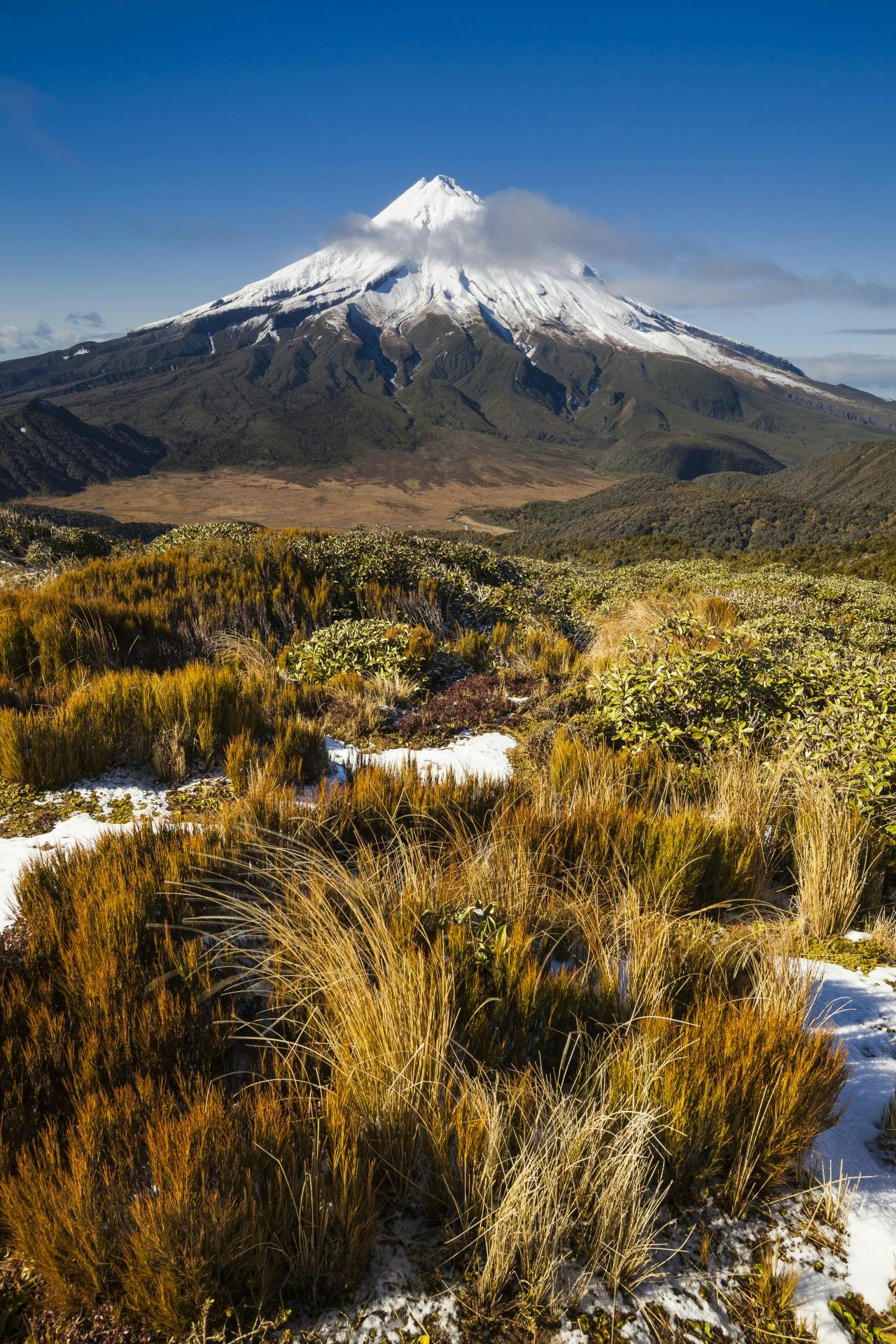
Views From Pouakai Range are arguably better than on the Tongariro northern circuit. Photo: Mark Watson
Touted as the ‘best one day walk in New Zealand’, the Tongariro Alpine Crossing can get a little crowded. You might be walking in single file with 1000 others during the height of summer. The actual 43km Northern Circuit takes punters 3-4 days to complete, staying in three huts en route. Circling around Mts Tongariro and Ngauruhoe, the volcanic craters and brilliant blue lakes are striking for their uniqueness to other tramping destinations.
If you want to flee the madding crowds, head west to the slopes of another volcano without the heavy traffic: Mt Taranaki/Egmont. Recently upgraded, the 25km Pouakai Circuit is shorter and sharper. Starting at North Egmont, the tramping track passes through forest, alpine tussock fields and the unique Ahukawakawa Swamp. Plummeting 31m, Bells Falls are also a worthy off-route deviation.
A side-trip to the summit trig of Pouakai is similar to the detour on Mt Tongariro; a bit of a scramble but not particularly difficult. The views from the Pouakai Range are arguably better, dominated by the symmetrical cone of Mt Egmont, and taking in the circle of the Taranaki Bight, far, far below. Trampers usually complete the circuit in three days, overnighting at Holly and Pouakai Huts.
Hollyford Track
Poor cousin to: Lake Waikaremoana
Lake Waikaremoana has its unique charm, cut off from the rest of the North Island by torturous gravel roads which take a small eternity to negotiate. The open forest of Te Urewera (formally Urewera National Park) features some of the most beautiful bush in the country and the fishing is second to none. Walking the 46km shoreline track is easy, though the big haul over Panekire Bluff may knock the stuffing out of some. Allow 4-5 days.
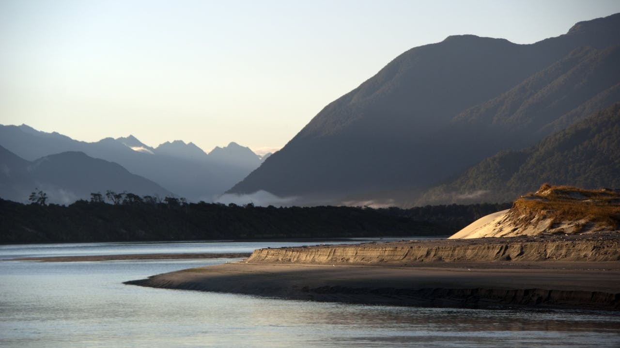
The Hollyford Bar at dawn. Darren Mountains in the distance. Photo: Ray Salisbury
A close cousin would be the under-rated Hollyford Track, which skirts the shorelines of Lake McKerrow and Lake Alabaster on its 56km one-way trek to the thundering Tasman Sea. No big bluff to climb over here, just the humble Little Homer Saddle (147m) and the much-maligned Demon Trail (which isn’t that hell-ish, if you are sure-footed and used to a bit of boulder-hopping). In recent years, DOC has upgraded all six huts, which are still under-utilised, so you’re almost guaranteed beds for the night.
Begin the walk near Gunns Camp, an anachronism from the last century, and gaze up at the sheer rock walls of the Darran Mountains. Some 3-5 days later, once you reach the beautifully-sited accommodation at Martins Bay, you are treated to unrivalled sunsets and one of the country’s largest seal colonies only a mere 10-minutes stroll away.
A jet boat or plane can be booked for a quick exit.
Queen Charlotte Track
Poor cousin to: Abel Tasman Coast Track
Our most visited National Park is undoubtedly the Abel Tasman, boasting the best beaches in New Zealand. DOC offers four commodious huts, and 19 coastal campsites along the 60km track. However, in my view, the Coast Track itself, while a very easy 3-5 day ramble, is somewhat over-rated. My memories are of gorse and quail, neither of which are endemic species. Perhaps the smartest way to experience this coast is by kayak or private launch.
An alternative to the Abel Tasman is the Queen Charlotte Track, which gets far fewer visitors. You can walk (or bike most of) the 70km, beginning from Ship Cove, where Captain Cook anchored on his historic voyages. The QCT is similar to the Abel Tasman in that it is also a coastal walk that dances in and out of regenerating bush. The main difference is there are no DOC huts, only a plethora of basic campsites. However, there is a range of wonderful lodges, backpackers and hotels dotted along the length of Queen Charlotte Sound, so you can enjoy ‘glamping.’ In addition to purchasing a QCTLC track pass, your packs can be transported by boat each day, allowing for more luxuries and gourmet food than you’d normally carry.
Clarence River
Poor cousin to: Whanganui Journey
While not really a great walk, the Whanganui Journey involves manoeuvring a kayak or Canadian canoe down a 145km section of the remote Whanganui River for 3-5 days. A short walk to the curious Bridge to Nowhere is a highlight; otherwise, there’s really nowhere else to go – you’re at the mercy of the river, as it meanders through narrow, steep-walled gorges and b
ush-clad valleys. Bookings are required for campsites and huts.
The Clarence River flows through big country. Photo: Robert Thomson/Creative Commons
I drifted down the Whanganui as a 14-year-old, on a summer expedition. It was mild, rather than wild. Two years later, I kayaked the remote Clarence River, which flows between the Inland and Seaward Kaikoura Ranges of Marlborough. While both voyages lasted five days, the latter was an entirely different experience.
Known as the ‘Colorado’ of New Zealand, the Clarence is one of our longest waterways, draining a massive catchment area totalling around 3500km2. As the Clarence twists and turns its way from Lake Tennyson, it gradually descends over a vertical kilometre throughout the entire 220km course to the Pacific.
Like the Whanganui, several companies will assist with boat hire. If you’re not an experienced kayaker, the best way to go down the Clarence River is by booking a tour with a local rafting company. While you’ll be paying at least $1400 each, this is a once-in-a-lifetime adventure, one best spent with close friends or in a family group.
Floating down the Clarence is a true, blue wilderness experience in a majestic mountain setting.
Hump Ridge Track
Poor cousin to: Kepler Track
DOC promotes the 60km Kepler Track as a ‘walk through the gentle beech-forested shores of Lakes Te Anau and Manapouri over exposed alpine tussock lands and Mt Luxmore (1472m) with panoramic views.’
Again, one must book well in advance and accept whatever weather is forecast for Fiordland. A little further south, and equally exposed, is the only private track inside a national park: the popular Hump Ridge Track. It’s a mere two kilometres longer than its Great Walk cousin, and costs about the same.
Beginning at Bluecliffs Beach, the track follows the South Coast then climbs a ridge onto the subalpine zone to Okaka Lodge, overlooking the southern ocean, far below. Rocky tors and tarns complete a magnificent vista. Dropping down another ridge to the shoreline, the track crosses historic viaducts to reach Port Craig. The final day enters native bush before following the coast to the starting point.
For a similar price to the Kepler, you can enjoy flush loos, running water, pillows, gas heating, porridge for breakfast, with all cooking gear provided. One can even indulge in local wines at the bar. Premium upgrades include a king-sized bed, or a helicopter to carry your pack!
