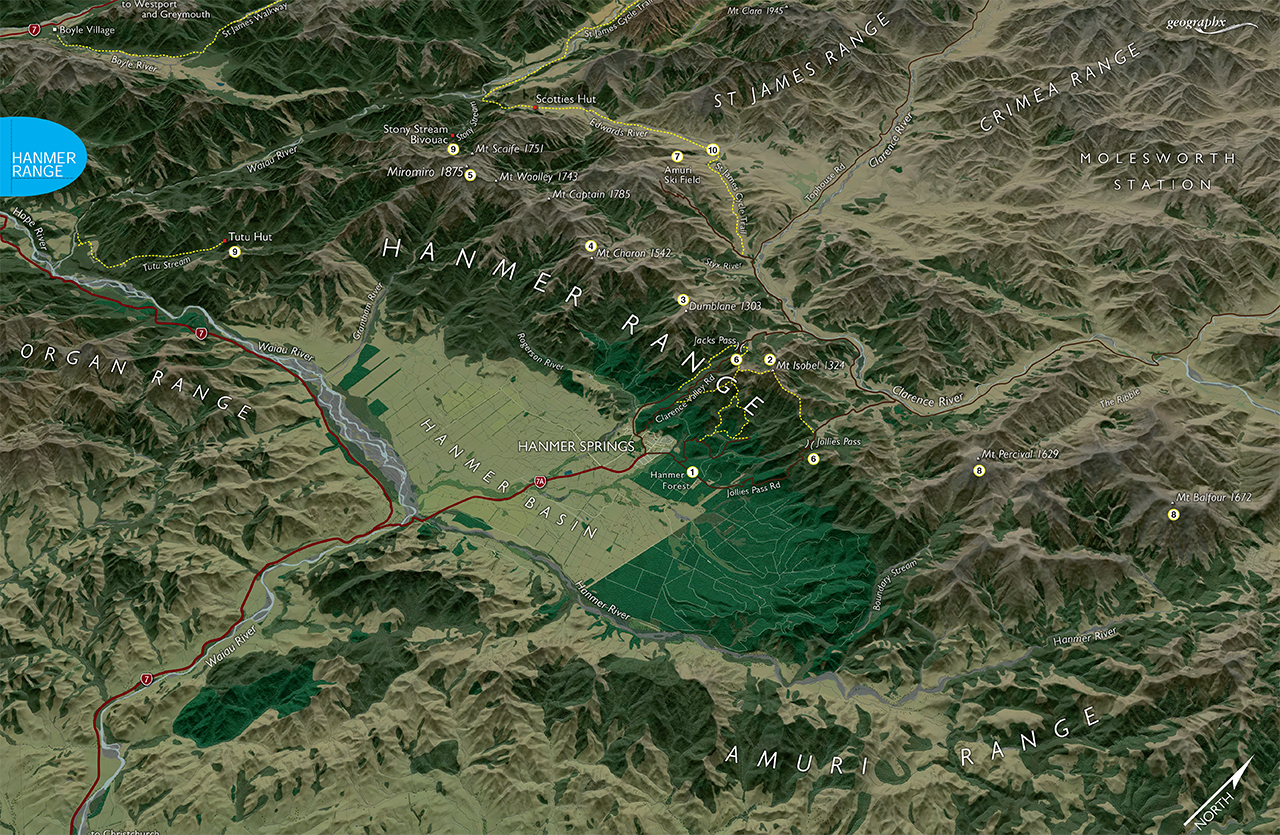
The Hanmer Range lies between the Waiau and Clarence rivers and is the boundary between north Canterbury and southern Marlborough and as such consists mostly of high, dry, and almost treeless ridges and valleys although many of the southern faces above the Hanmer Basin are well vegetated.
Most visitors will know only of the short tracks and mountain bike trails which run through Hanmer Forest Park near the resort town, but what is lesser known are the high tops and remote valleys on the northern side of the range where it runs down to meet the Clarence River. This portion of the range provides some moderate challenges for recreation amid these wild and tawny hills.
1 Hanmer Forest
This small forest, consisting of many varieties of exotic as well as native species is laced with numerous walking and mountain bike trails – too many to mention here – and is the focus for many of the visitors to the nearby thermal resort.
2 Mt Isobel
Any casual observer to Hanmer Springs will have often gazed at the attractive little summit of Mt Isobel (1324m) standing immediately above the resort to the north. Its rounded summit is a popular trip and walkers are well-catered for through the variety of marked trails heading summit-wards.
3 Dumblane
West of Mt Isobel stands Dumblane (1303m) a less visited summit with great views of the Hanmer Basin and Waiau Valley. It can be accessed from Jacks Pass which is also one of the more popular ways to reach Mt Isobel.
4 Mt Charon
West from Dumblane, ridge walkers will encounter Mt Charon (1542m) on the crest of the Hanmer Range. It can be reached in a moderate day outing from Jacks Pass and has spectacular views, especially in winter.
5 Miromiro
The range’s highest summit is Miromiro (1875m) lying well west of Mt Charon and entailing a 2-3 day trip via most routes. On the way you might also be able to capture Mts Captain, Woolley and Scaife – all around 1800m and providing good scrambling in grand surroundings.
6 Jacks and Jollies Passes
These two road passes lie west and east of Mt Isobel, respectively, and are the focus for road trips (4WD only over Jollies) to the Clarence Valley. They can also form the route for a great mountain bike trip or a tramp over Mt Isobel and back down to Hanmer Forest Park.
7 Amuri Ski Field
About where the St James Range abuts the Hanmer Range is Amuri Ski Field, a local club scene for skiers and those wanting something a little different. Though the field offers only modest terrain it’s friendly and welcoming.
8 Mt Percival and Mt Balfour
At the north eastern end of the range these two high summits, 1629m and 1672m respectively, can be reached via a long traverse from Jollies Pass.
9 Huts
There are few here but two that are of interest, and remote, are Tutu Hut in Tutu Stream on the southern side of the range, and Stony Stream Bivouac in Stony Stream to the north. Both will require at least a two-day trip, and in the case of Tutu Hut, the local farmer’s permission.
10 St James Cycle Trail
The new St James Cycle Trail begins just north of the range on the Tophouse Road in the Clarence Valley and passes through the Edwards Valley to the Waiau and later back to the Clarence over Maling Pass – a 64km circuit.