Home / Trips / Northland

Urupukapuka Island, Bay of Islands

Image of the April 2019 Wilderness Magazine Cover Read more from the
April 2019 Issue

Island paradise of the north

The holiday begins before the ferry grinds to a halt at Otehei Bay wharf, scattering stingrays on its approach.

Deeply set in its headlands, the gorgeous bay is a sheltered haven for boats, lounging visitors and fish. Sizable snapper and kingfish guard the wharf – tempting even the honest to ignore the no fishing signs – and bird song greets the ears of disembarking passengers.

Thanks to the pest control work achieved by Project Island Song, walkers have a good chance of spotting rare birds here; saddleback, pāteke, tui, North Island robin and whitehead inhabit the forested areas of the island. It’s a step back in time.

A 7.3km track covers most of the 208ha island. The walk map – colour-coded like a subway route – can be overwhelming to make sense of and is best tackled in a clockwise direction.

From Otehei Bay, follow signage to the track start, climb the grazed grassy ridge to the trig station and veer left towards Paradise Bay (Oneura).

It’s a steep, but well-trodden track through fragrant manuka which – combined with sea views – reminds of Abel Tasman National Park.

Keep an eye on the waters whenever you reach a headland – spotting the dark shadows of stingray from a height is almost a given, and dolphin and orca frequently cruise by.

Perhaps due in part to its enticing name, Paradise Bay is a popular anchorage spot for boats, boasting clear waters, golden sand, and ample shade, thanks to some well-placed pohutukawa.

It’s an excellent swimming spot, but it’s also the first of many, so don’t stress if you’re not quite ready for a dunk.

Otehei Bay is home to the island’s wharf and pub. Photo: Matthew Cattin

Cut back into the bush, and climb north over the headland to Indico Bay (Otiao) – it won’t take more than 10 minutes, and a short side trip inland leads to a viewing hide overlooking swampland, where you may spot endangered pāteke.

A detour to the sublime Akeake Beach is well worth the walk from Otiao. The often deserted strip of sand at the end of Te Akeake Point is one of the island’s best, although lacking in shade.

Return back to the junction and, to complete the loop, veer north-east to the spectacularly-sheer eastern coast.

The track grazes close to the edge in sections, offering impressive views east to Cape Brett, and far below to some impressive arches, deepwater guts and heaving swells. It’s one of a few gravelled sections of the track.

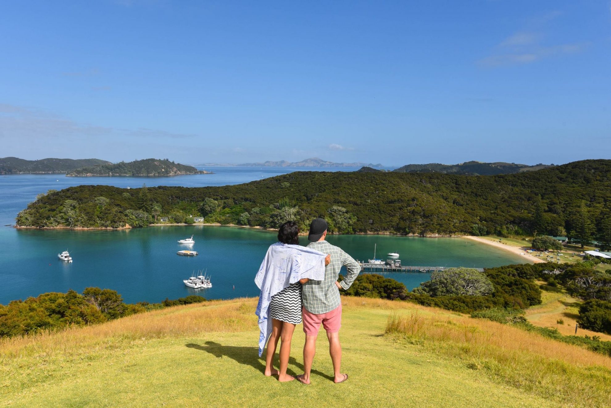
The highest point on Urupukapuka, 106m, is reached on this stretch, offering one of the most comprehensive views of the Bay of Islands.

Purerua Peninsula extends in the north-west, and Cape Brett to the east, and everything in between spreads out on the deep blue carpet.

On the descent, bear left at the fork to swing by Urupukapuka Bay – the largest campsite on the island.

Facing south-east, the sheltered beach overlooks Rawhiti, and its ever-calm, clear waters have fostered thick weed growth, covering all but a few patches of the sand. Swim here if you wish to count your toe hairs at chest depth – it’s clear enough.

A steep track leads south over the headland, bringing Otehei Bay back into view. If you’re ready to relax, end the trip here, but should you wish to see more, a loop encompassing the campsites at Cable and Sunset bays is worthwhile. The latter is my favourite beach on the island – private and backed by delicious native bush.

Explorable in a day, you will want to stay longer.

Distance
9.4km (including loop to Cable and Sunset Bay)
Total Ascent
378m
Grade
Easy
Time
5h
Access
Ferry from Paihia or Russel, or private vessel
Map
AV28

GPX File

Urupukapuka Island (gpx, 7 KB)

GPX File

Your device does not support GPX files. Please try a different device.