
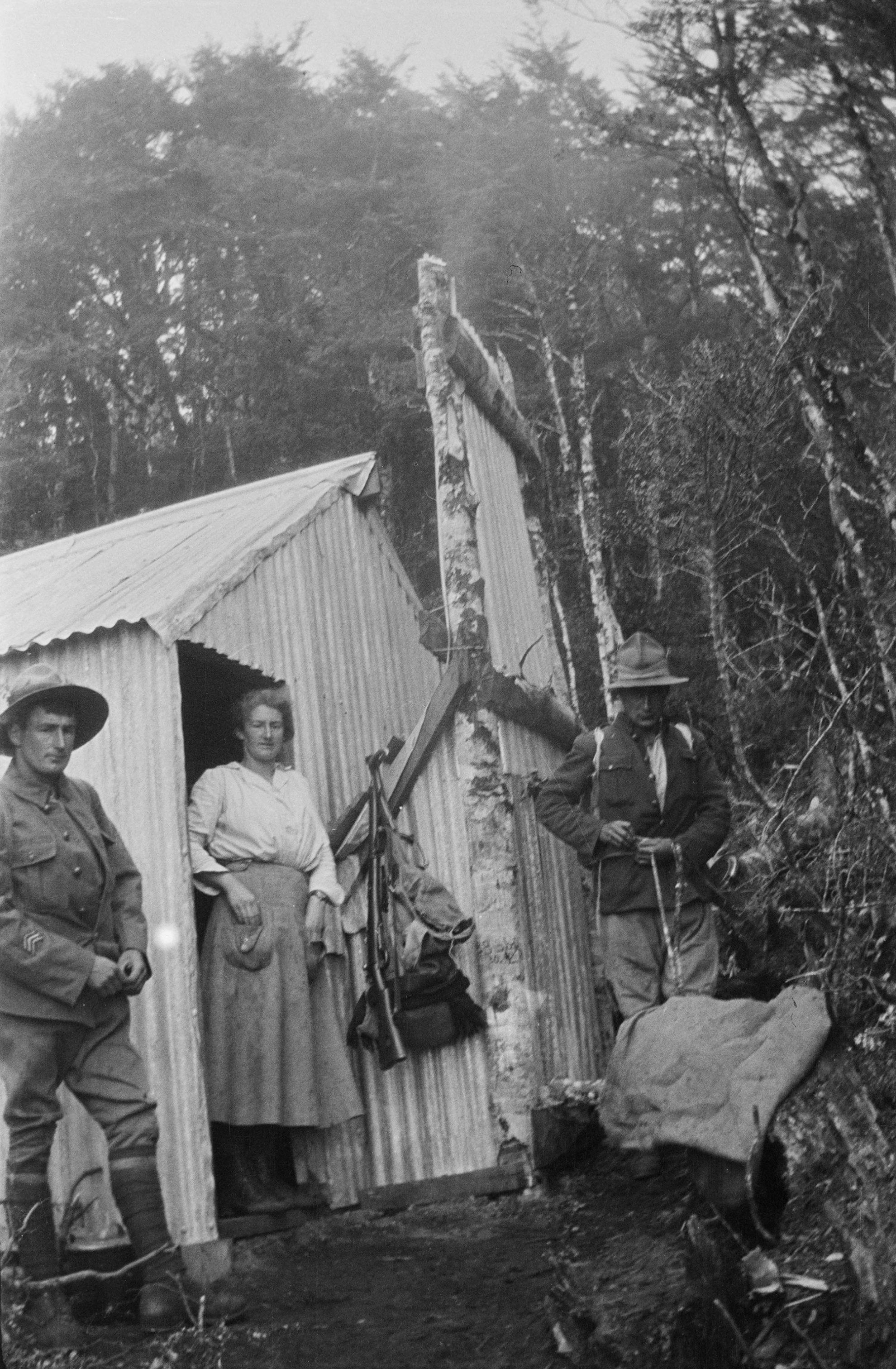
New Years Eve, 1919, and the small rabbiter’s whare on the steep eastern slopes of the Ruahine Ranges is packed with young people. Canvas has been slung outside as an additional sleeping shelter. The whare is full of smoke from the poor chimney draw, leading the group to name the hut Shuteye Shack.
In the morning three of the boys – Ted Bibby, 23, his brother Bruce, 21, and friend Edgar Swain, 20 – will set off on an epic crossing of the Ruahine Ranges. They have no map, there are no tracks and they have no guide. Their siblings have come up the mountain to wish them well on the journey.
Ted is a returned soldier. Bruce and Edgar also joined the army but the war has ended before they have seen overseas service. The Ruahine crossing will be their summer adventure before settling into civilian life.
Fast forward to last summer and a group of us are heading up the side of the mountain to re-enact their trek. I am 57, Neil is 67. We are Ted’s grandchildren. Hugh, 78, is Bruce’s son. We’ve grown up with the story of the Ruahine crossing. Bruce kept a diary of the walk, Ted wrote about it in his memoirs and they all took photographs. But they didn’t map their route, so we’re accompanied by a guide, expedition leader Graham Leech, who has a DOC concession for commercial guiding in Ruahine Forest Park.
Our route is from the North Block Road end via Armstrong Saddle to Top Maropea Hut, then to Maropea Forks Hut. From there we will climb Puketaramea and descend to Iron Bark Hut. Our final leg is outside of the park, across the Mokai Patea.
One and a half hours in and we are at the former site of Shuteye Shack. My grandfather described the hut as the ‘new’ rabbiter’s whare. The ‘old’ rabbiter’s whare was at the top of the mountain in Buttercup Hollow beside a small tarn. In 1983 Sunrise Hut was built beside the tarn and replaced both whares. These days Buttercup Hollow is dominated by buildings and a helicopter pad. On our visit the tarn was dry; there were panoramic views across Ruataniwha Plains.
It took an hour from Sunrise Hut to Top Maropea Hut, which is sheltered and allows fine views of the ranges we were yet to cross. That night we slept warmed by the fire, listening to the roar of stags in the distance. We marvelled that the three young men had walked across these mountains without a map, carrying their gear and food in flour bags, plagued by flies and with an oiled canvas for a tent.
Next day we went down the mountain track to the Maropea River through a fine stand of kaikawaka, New Zealand cedar. Berries were plentiful: the dark pink of Lobelia angulata and the little white fruits of the soft mingimingi shrubs. Bright orange clusters of karamū hung above the slate grey rocks and clear pools of the Maropea.
It was a leisurely five hours down the river to Maropea Forks Hut. We noted the lack of bird song and sightings. The river, which we crossed about 120 times, has a range of deep and shallow pools, small waterfalls and a pretty gorge. Several times it opens into sunny clear flats.
Maropea Forks Hut is sited on one such flat above the flood line. It’s a nice place to dry out after a day in the water.
On their first day the boys had trekked in a westerly direction off the mountain tops and down to a river. They walked until darkness fell and slept overnight on wet sand, waking cold when their fire burned down. Then they headed downstream, crossing and recrossing the river many times. Bruce described it as ‘jumping from boulder to boulder, scrambling up and down great pieces of rock in the riverbed, wet to the waist by the river and nearly wet to the skin with rain, which fell all day’.
In his memoirs, Ted said ‘the going was difficult’.
‘In one creek we found ourselves sliding down several waterfalls. We decided that one waterfall would slide us into a river walled in by cliff faces and had to climb back the way we had come down. This happened several times.’
Their second day, like ours, ended at the junction of a stream. However, it’s clear from their description that it was a different mountain stream to ours. They camped on a bed of wet fern between two large rocks, over which they slung their canvas fly. We agreed that we had enjoyed a better walk on our second day than had our forebears.
The boys’ third day would take them out of the Ruahine Ranges.
Our third day was the longest – seven hours to Iron Bark Hut. It was a cloudy, misty wet walk straight up from Maropea Forks to the top of Puketaramea (1338m), a stiff climb that we took at a slow even pace with plenty of rest stops.
When we emerged from the bush to cross the summit, the growling wind was sending mist scurrying across the top of Puketaramea, so it was a quick scramble to the bush on the other side. The contrast was astonishing – we suddenly found ourselves walking along soft grass paths beneath filtered light in pleasant conditions. The tops opened into a small clearing of tussock with large orange-lichened rocks.
The descent off Puketaramea goes through thick grassy groves of ancient beech trees with soft leaf litter that is pleasant to walk on. It’s stunning. Sometimes, a slight breeze would pick up the little leaves and flicker them over the ground. Ferns and mosses edged our path, and the grasses gave way to masses of waist-high fern as far as the eye could see. Scattered throughout were giant beech trees, so tall their crowns were out of sight. They fell away far below us into the mist. We stopped to measure one of the largest trees – its circumference was about 9m. We estimated the trees to be 40–50m tall.
Finally, some birds: in a patch of sunlight up in the boughs of a beech, a large flock of pōpokotea (whitehead) fluttered about, full of busy, noisy chatter. At our feet, two pure white butterflies, possibly the tarata flat moth (Nymphostola galactina), fluttered out of a mossy hollow.
On this section we encountered misleading signage. One sign suggested the hut was two and a half hours away. Several hours later, another sign repeated the same time to the hut. Furthermore, the track turn-off to Iron Bark Hut is much further down the spur than indicated on the topo map, and the swing bridge across Maropea River has been relocated closer to the hut. The track to it has been re-routed directly from Pt770. We were thankful to have Graham as our guide.
After a long slow descent we suddenly dropped steeply to the swing bridge and the vegetation changed to groves of ponga, lancewood, kōwhai and ongaonga. From the bridge, it’s 10 minutes to Iron Bark Hut.
Three hunters made room for us, stoking their fire and sharing hot water for a welcome brew. It was our third and final night in the Ruahine Range and we retold our forebears’ story, how they had made their way through the ranges more than 100 years ago.
Their last night in the mountains had been a sleepless one on the riverbed. Bruce spent most of it drying his clothes in front of the campfire. In the morning they left the river. Bruce wrote that they ‘struck up the bank’, and ‘for the next three hours we crawled, struggled and forced our way through wet bush and scrub until we reached a point from which we could see cleared land’. It took them two hours to walk off the ridge down to a river, which they followed to where it joined the Rangitikei River.
Their trek out of the mountains was remarkably like ours. From the river, we started with a steep climb for about two hours. This flank of the Ruahines was not-able for rimu and birdsong. We saw several kererū and I was convinced I heard a kōkako. Half an hour into our walk we came across a giant powelliphanta snail on the leafy track.
Our trek took us to the park boundary from where we could see cleared land. We had permission to cross the farm and took a route up a spur to a sunny sheltered spot on the edge of the bush. Here were fine views overlooking the Rangitikei River, with Ruapehu and Tongariro in the far distance and Aorangi nearby. A short walk through golden tussock led to the round drum of the Mokai-Patea. It took an hour and a half to get down to the DOC Ruahine Forest Park noticeboard, and from there it was a pleasant level walk to the Mokai Road end.
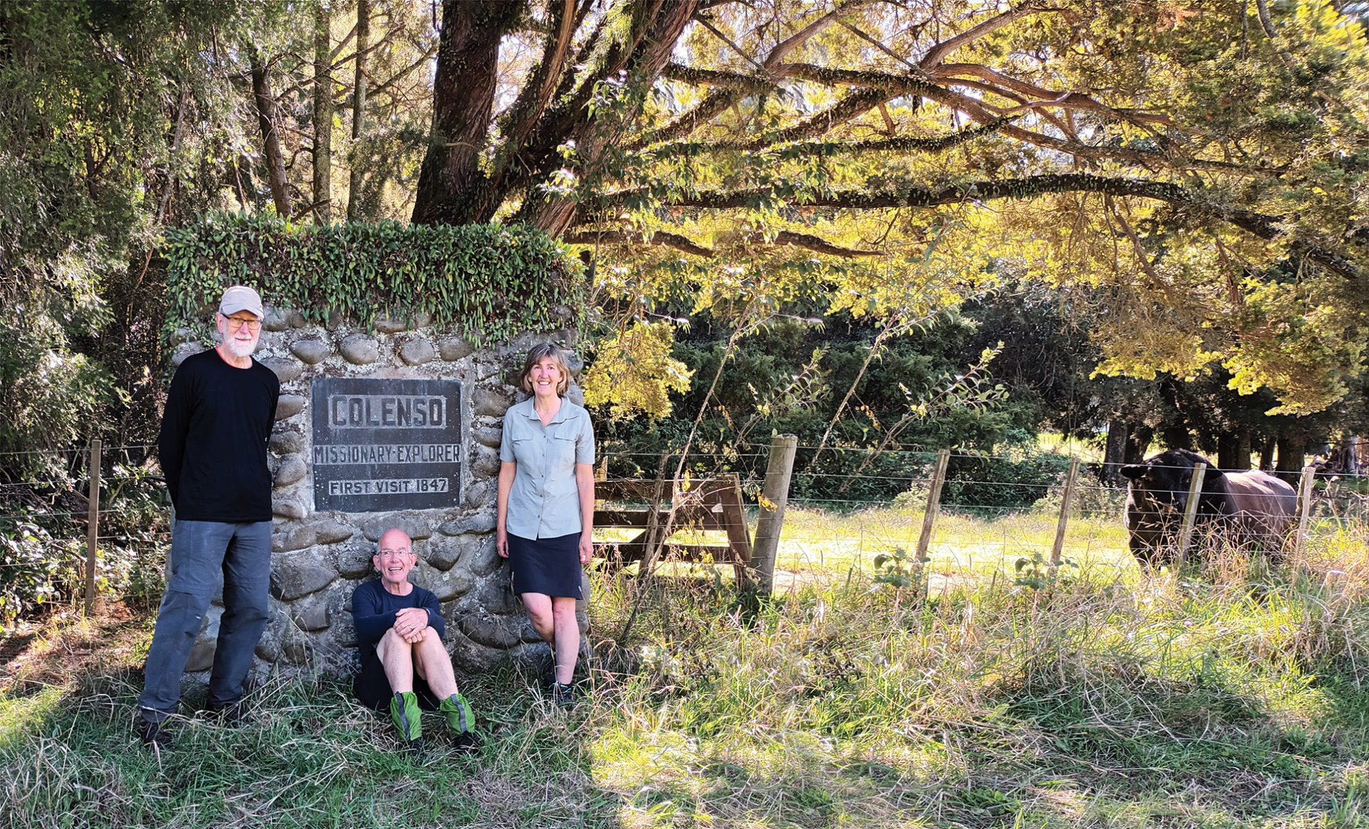
We took our end-of-trip photographs at the Colenso Memorial, erected to commemorate William Colenso’s 1847 Ruahine Crossing, before setting off to Gretna Hotel at Taihape for hot soup and a warm shower. Our forebears had stayed here, but had one more night of camping before they arrived. They slept on a bed of mān-uka and after breakfast called in at the first farmhouse they came upon. They learned that Taihape was 30km away and walked the distance in under five hours along the roads. The boys spent a few days in Taihape and Marton then took the train home to Waipawa.
After their 1920 crossing, Ted and Bruce farmed together on the family farm at Ongaonga for a few years, then Ted took on the farm himself. He married in 1926, and in 1964 was awarded the MBE for community service. Bruce became a dentist. He was Director Dental Hygiene for the NZ government and director of the School of Dental Nurses. He married in 1939. Edgar, a concert tenor, married a professional singer in 1925 and they sang professionally until his World War II service. He later became a mining investor and businessman in Australia, achieving multi-millionaire status.
In December 1922, brothers Bruce, Hugh and Basil Bibby and their friend Lionel Swain returned to the mountains and walked from the rabbiter’s whare along the length of the Ruahine Range to Ashhurst and Woodville, then caught the train home to Waipawa.
Reflecting on our walk, Graham said our fitness and preparation had served us well. One hundred years ago, without maps and tracks, it would have been much more difficult.
34 years of inspiring New Zealanders to explore the outdoors. Don’t miss out — subscribe today.

Questions? Contact us


