


Ticking off the squiggly tracks on a map, one by one, led this tramper to dream up her biggest trip yet: a multi-day traverse of the Richmond Range.
Most of my childhood was spent in the rural town of Brightwater, 20km southwest of Nelson. I walked to school with the peaks of the Richmond Range in front of me and, in time, Richmond Forest Park became my first tramping playground. The park map was the first I owned, the first to become graffitied with black lines as I marked off completed tracks.
I spent hours poring over that map. One possible trip stood out as the ultimate: a complete, solo traverse of the Richmond Range. I envisaged starting at Mt Riley, walking south along the range’s spine and finishing down the Red Hills Ridge near St Arnaud.
When I first started dreaming about this trip I wasn’t skilled in off-track navigation and I hadn’t done any solo tramping. Over the years the goal remained but for various reasons, it was never a priority. Then, 30 years later, I rediscovered my old map. Now, I had the necessary skills and experience, and my passion to embark on this life-long goal was reignited.
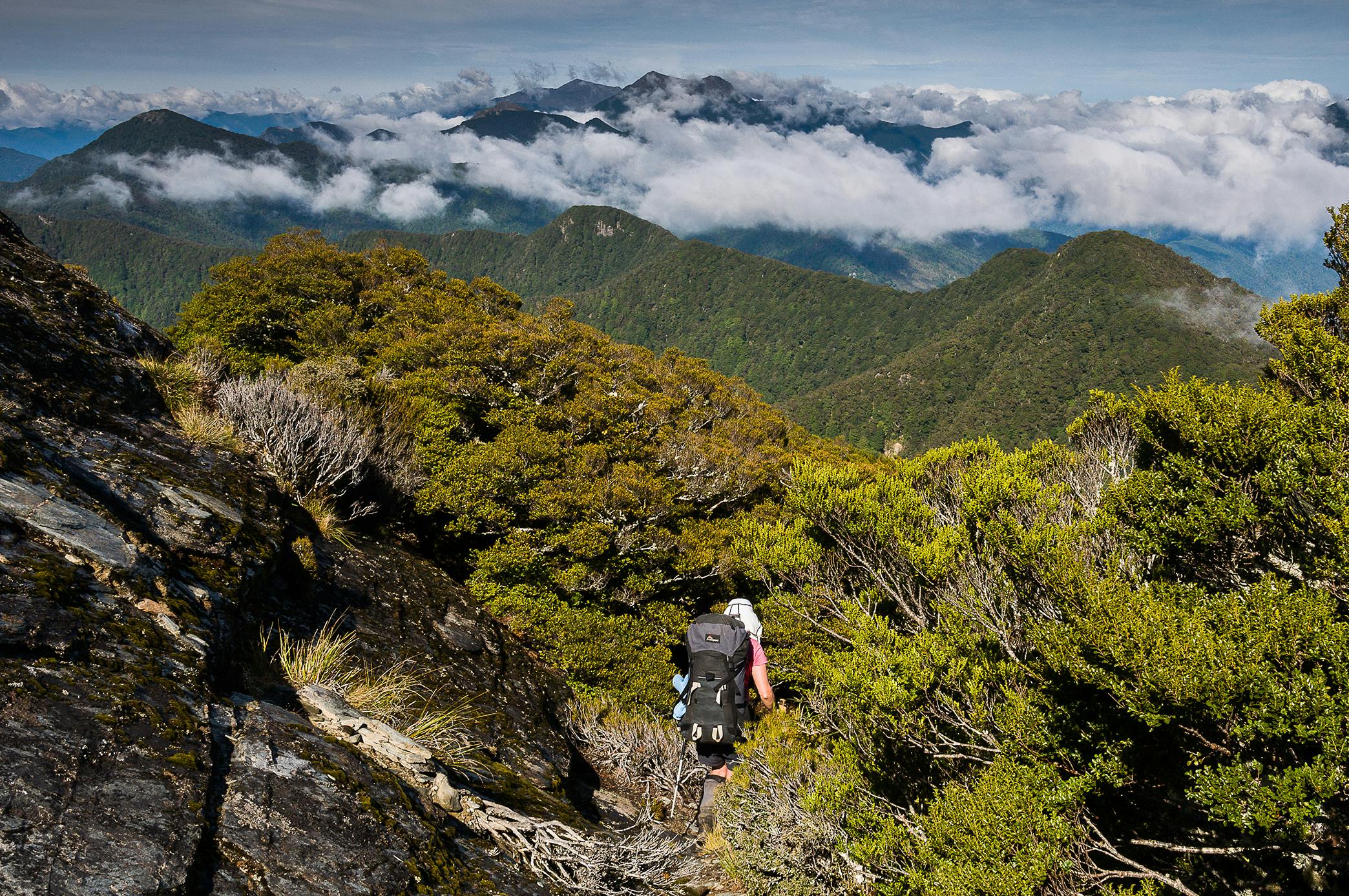
The Richmond Range is largely forested with just a few peaks above the bushline. The ridge is undulating with lots of altitude gain and loss but mostly stays above 1000m. The traverse would involve untracked travel along ridges, often in stunted subalpine beech forest, and some easy travel along tracks and across open tussock tops and rocky ridges. I’d need a tent or bivvy bag, but there were some huts along the way. There were many exit points along the range and much of the trip would have cellphone reception.
I had previously done the crux of the trip with my husband, across a gnarly ridgeline from Richmond Saddle to Ada Flat, and I remembered some thick bush-bashing, a few steep rocky knobs and one particularly scary and worrisome down-climb.
A big challenge would be water, but I would carry four litres so a camp without a water supply would be possible.
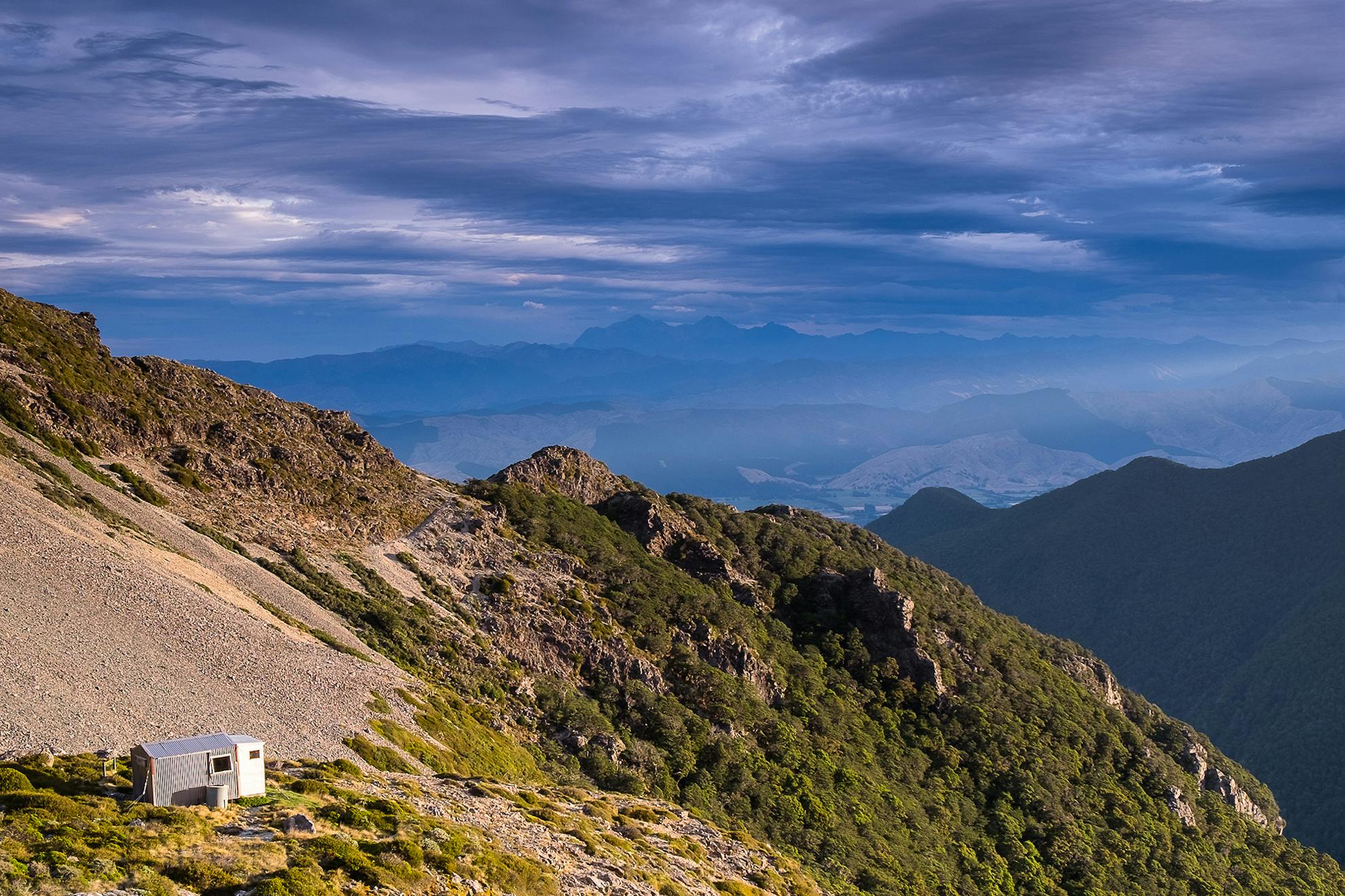
Brave but foolish is the best way to describe my first attempt in October 2015. I really did feel brave; I was on my way. But I didn’t get far. My pack was crippling. With my tent, camera equipment and food for 12 days, I knew within a couple of hours of starting the 1200m climb to Mt Riley that I wasn’t going to persevere – this time. There was none of the joy, excitement and pleasurable anticipation of my imagination. Instead, I had a burdensome, bulging pack weighing me down both physically and mentally. I berated myself for pretending I was a photographer (did I really need two lenses?), for bringing so much food (why did I allow 12 days?), for carrying a tent (why didn’t I bring my bivvy bag?) and for not being fit enough. By the time I arrived at Mt Sunday Bivouac I had talked myself out of continuing, and instead, before heading down, spent a couple of nights camped on Mt Sunday taking photos.
Four months later, I was much better prepared. I ditched the tent and carried a lightweight bivvy bag. I took only one camera lens and went lighter on the food. From Mt Sunday Bivvy I followed the easy bush ridge to Fosters Hut, where I spent three nights sheltering from rain and worsening weather, thus once again forfeiting my chance of completing the full traverse.

When the weather finally cleared I continued on over Mts Baldy, Royal and Fishtail to Fishtail Hut. A great bivvy camp along the way softened the blow of failure, as did gaining another black line for my map by walking out from Fishtail Hut to hitchhike back to my car.
It was a few years before I decided to give it another go. It was May, the days were short and cold. Was I setting myself up to fail again? I decided success relied on putting in a food dump and allowing two full weeks. Pack weight would be manageable, and there would be spare time in case of bad weather. It would be cold so I would take the tent, but I would leave the camera behind and use a phone instead. I would carry eight days’ food and have seven in the food dump.
This time, starting in heavy rain that was forecast to clear, I took the direct track to Mt Sunday rather than going via Mt Riley. I thought I could cope with the rain, but I couldn’t. I reached the biv and cried. It was Mother’s Day and I was alone, soaked and freezing. I thought I’d feel better in the morning, but I didn’t. With rain still falling I went back to sleep, questioning whether I could do this trip.
When I awoke the cloud was breaking and steam was rising from a pile of wet clothes. The weather continued to clear; the sun sucked all the moisture from my gear and removed any lingering doubts I had about my capability, determination and desire to do this traverse. Sometimes things are just hard. I realised that achieving this goal was about deciding to succeed. I had put in place the practical things for success. Now I needed the mental strength to commit to this journey.
With dry gear and a full stomach, another decision arose: should I go back to Mt Riley so I could claim the full traverse of the range in one go, or just get on my way? I’d been up Mt Riley on my previous attempts, so opted to leave it. I wanted to capitalise on my newfound optimism, and going backwards seemed counterproductive.
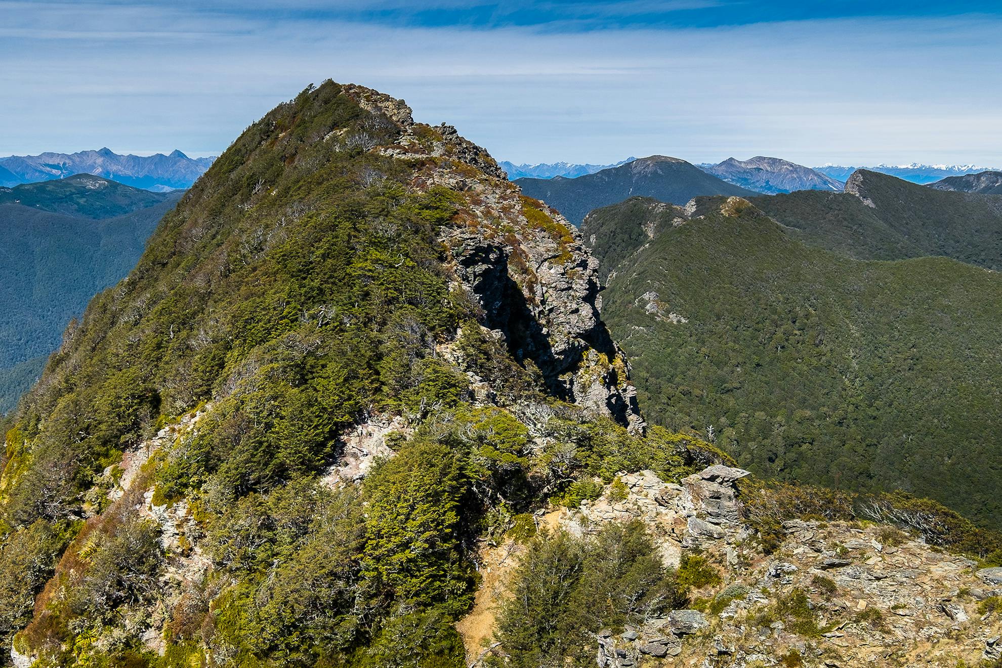
The next few days to Fishtail Hut were spent in familiar territory. It was new country beyond this and I felt apprehensive. It was slow going across an untracked bush ridge and stunted beech forest that had me swearing a couple of times. I arrived at Mt Fell Hut at dusk to a large pile of firewood. Things were working out well. As each day passed, I was becoming fitter and stronger and more confident that this would be third time lucky.
Snow fell below the bushline that night and careful footwork was required on the way up Mt Richmond. My feet, like the scree under them, froze solid on the descent through swirling cloud to Richmond Saddle Hut.
It was wet and misty next day, so I decided to have a pit day. I didn’t want to tackle the upcoming ridge to Ada Flat in bad weather.
The following morning I set off before dawn, carrying four litres of water so I could take my time and camp where it suited. It was a difficult section. There’s a series of short, sharp, rocky knolls in the stunted forest, some with clearings on top, others covered with dense beech. I approached each one with apprehension, nervously anticipating the down-climb that had scared me last time. I was constantly surprised though, as each knob had a route off the back – that is until the top of Pt1391. There in front of me lay the steep, bare slabs I’d been worrying about for the last week. I didn’t want to climb down on my own. I looked around and found a steep gravel chute not noticed the last time. Hanging from stunted beech, I gingerly went down. It was steep but it took me below the slabs. Phew, I had just completed the hardest part of the ridge.
With the crux behind me, I pitched the tent in a small mossy clearing and enjoyed the last of the sun.
I awoke with a temperature, a headache and a sore throat. Surely a developing virus wasn’t going to thwart me now? I was to pick up my food dump today but decided to spend a quiet couple of hours drinking tea and resting in the sun. Eventually, the allure of the food stash triumphed over the lethargy of my sickly body. I was particularly excited about a large packet of potato chips and a Braeburn apple, so headed up to Old Man Hut to retrieve my food.
I felt much better after a good night’s sleep. I re-sorted my food realising I had far too much for the rest of the traverse. Non-perishables were left behind in a plastic box. There was some extra good fare, including walnut crackers, peanut butter, tuna, muesli bars and a few freeze-dried meals. Someone was going to get lucky.
I now had a couple of days on Te Araroa Trail before heading off-track again to tackle the final high traverse over the Red Hills.
I left Te Araroa a short way after Tarn Hut and followed a bush ridge until nearly dark. It was my first campsite under the forest, and I ate dinner outside by candlelight. For the first time, I felt scared to be alone. I was constantly jumping at my own shadow and irrationally started worrying about pigs attacking me. I blew out the candle but it didn’t help, so I crawled into the tent. It was much better being cocooned inside than sitting out in the eerie forest alone.
It was a strange mixture of fear and excitement at the anticipation of finishing the traverse. Barring extremely bad luck, it seemed likely I would finally complete it.
The following morning I dropped through easy forest to Wards Pass, which, at 700m, was the lowest point of the last 12 days. Today I hoped to reach the highest peak of the journey, Maungakura / Red Hill (1791m). And so I began the last big climb through steep beech forest and onto the stunted shrublands of the infertile ultramafic rocks of the Red Hills.
As I climbed higher, tussock gave way to bouldery scree. It was terrain I enjoyed. The rock was grippy, but travel was slow. I was almost out of water and it was very cold. I changed my goal for the day and decided to set up camp by a small tarn in a basin under Maungakura/Red Hill. This was without a doubt the right thing to do as ice was already forming on the tarn when I arrived. Cocooned in my sleeping bag, I cooked dinner and contentedly watched the sublime sunset from my tent.
In the morning I waited for the sun to reach the tent before leaving to climb Maungakura. The Richmond Range stretched out behind and I could see Mt Richmond, which I had climbed in the cloud with frozen feet seven days ago. With lots of time and a clear sky, I would surely make Red Hills Hut today. But first I had a coffee spot to find. In my food dump I’d packed some real coffee to celebrate with when I felt confident of completing the traverse. Now was the time to enjoy it.
Later, as I weaved around the tarns and through the dense tussock of the Red Hills plateau, I wondered if I might have lingered too long over that celebratory coffee. A camp on the boggy plateau was starting to look likely, but luckily, some mountain bikers had lit an outdoor fire at the hut and that guided me in the near dark. Rather than cramp their style, I had my dinner then continued down the easy 4WD track to the road end.
A couple of things preyed on my mind as I wandered out under the starry sky. The trip had taken 13 days. Did I really need all that time? Some days I had only walked four hours and I had also left a lot of food behind at Old Man Hut. Could I have done it in one stretch, in fewer days with no food drop? Maybe. But then I remembered I had already tried that before and failed – twice.
Was this trip third time lucky? I certainly had some good luck along the way. The fire guiding me to Red Hills Hut was lucky; recovering from a virus overnight was lucky; having plenty of good weather seemed extremely lucky. But just as important was the mix of planning, patience, perseverance, determination and discipline it took to do it.
I had finally made the trip happen after dreaming about it for over 30 years. I could now fill in the last of the gaps on my old park map. My sense of pride was immense.
- Distance
- 100km approx.
- Total Ascent
- 8000m+
- Grade
- Difficult
- Time
- Up to 12 days
- Accom.
- Multiple huts and camping
- Access
- To Mt Riley Track – Follow Northbank Road (Wairau Valley), Onamalutu Road onto Briggs Road and Davies Road to car park (check DOC website for logging road closures)
- Map
- BQ26, BQ27, BR25, BR26
