
I have a confession to make.
Even though I’m A) in my 30s, B) have worked in outdoor recreation for more than a decade, and C) am a writer for an outdoors magazine, until very recently, I didn’t know how to navigate with a map and compass.
Whether it’s generational, geographical, or just laziness, I’ve somehow managed to enjoy the wilderness (and not get lost) without the very basic knowledge of how to use the most reliable navigational tools in a tramper’s arsenal.
I don’t believe my experience is unique; the art of navigating with a map and compass is something few of my tramping compadres can master. In the age of smartphones and pocket-size GPS devices, it’s a skill that may seem archaic to most millennials.
So, I decided it was time to go back to basics. I signed up for an introductory bushcraft course, or, as I came to call it, Tramping 101, and joined a group of students just starting out on their tramping journey.
The course was held in Tauranga and taught by Outdoor Training New Zealand instructor Gerry Purcell who has more than 20 years experience teaching outdoor skills.
The students participating in the course were going for their bronze Duke of Edinburgh, but the information and skills covered are what you would expect from most beginner bushcraft courses.
Managing risks
Purcell and co-teacher Robyn Denize began by splitting us into small groups. Each group was given a newspaper clipping with a story about a person who had an emergency in the outdoors.
The groups were asked to evaluate what happened in each scenario, and determine what went wrong. From stories about lost and stranded trampers to injuries on the trail, we pinpointed where the tramper made a mistake. Whether the person wasn’t prepared for conditions or had set off alone into unfamiliar territory, we identified the risk factors and talked about how to prevent “lemons”, or unfortunate predicaments, on a trip.
“Three lemons in the outdoors spell disaster,” Purcell said, and asked us to repeat over and over the phrase, “The bush is safe until I forget that it’s not.”
Managing risk factors would be a major element in the trip-planning portion of the training.
Denize then covered the importance of respecting Maori culture and heritage while tramping; for example, choosing not to stand directly on the summit of a mountain, as it is considered tapu. “It takes a bigger person to not walk those final five metres,” she said.
To be a leader
Purcell gave us a breakdown of what it means to be a leader in the bush. With a bit of brainstorming, we identified key characteristics of a good leader: supportive attitude, knowledge of the group members’ abilities, possessing relevant experience, good communication skills, and ability to delegate.
The instructors then introduced risk management to trip planning. Identifying causal factors that could create a loss – unskilled participants, faulty gear, or low fitness levels – helps a group leader to prepare in a way that manages, minimises, or eliminates the potential losses.
While it’s unlikely most adult tramping groups will develop a risk management plan for each and every outing, it’s important to, at the very least, consider causal factors that could lead to a trip-ruining incident.

Equipment
Then came the practical elements of bushcraft: stoves and fuel, food, and clothing. We covered the many types of cooking options, from solid fuel/hexamine tablet cookers to the small-but-mighty biofuel fed collapsible stoves.
Remembering my own mishaps with camping stoves, I told the students the story of when I once nearly burned down a picnic table after lighting a stove that had a leaky fuel line. I had been leading a kayak trip with a group of teenagers and I hadn’t noticed the leaking fuel while priming the stove. Upon lighting, whompf, the whole table caught on fire.
Denize then demonstrated how to use each type of stove, and allowed us to have a go at lighting each one.
Purcell then launched into a discussion about what food to bring on a tramp, highlighting the importance of choosing meals that will provide the right type of energy when you need it. For example, he recommended slow-release breakfast foods such as oats, and suggested quick-release snacks like trail mix and chocolate. For lunch and dinner, he said proteins can help repair muscles and provide energy, and fats such as cheese can be a great source for slow-release energy.
Denize then unloaded a pack full of clothes for the class to see the best options for tramping attire. The biggest lesson: don’t bring anything cotton – polypropylene and wool are the best for keeping you warm and dry.
River crossings and bush safety
With drowning being a leading cause of death in the backcountry, learning how to safely cross a river was always going to be on the cards.
OTNZ offers an entire course dedicated to this topic alone, but Purcell and Denize introduced the basics and demonstrated how it can be done safely in a group using the mutual support network, in which trampers link up and cross as a unit.
Asking for two volunteers, the four of them donned packs and put their arms around one another, underneath each other’s packs, holding onto the shoulder straps of the person next to them. The largest and strongest person should be positioned upstream, as they’ll be most able to withstand the current. The least experienced and smallest trampers should be in the middle. Walking as a unit, a group of two or more should be able to cross a river safely, as long as the water isn’t higher than mid-thigh, or flowing faster than walking pace.
The river crossing discussion led into survival information, for which the instructors had some key pieces of advice; leave your intentions by telling your friends or family where you’re going; always know where you are by carrying a map (and knowing how to use it); and carry a spare meal.
The instructors set out some guidelines for what to do if you do find yourself lost: try to conserve energy by staying in one spot; construct a shelter; build a fire, for warmth, as a morale booster and to send smoke signals for rescue parties.

Purcell stressed the importance of bringing a survival bag on every tramp, recounting the time he had an unexpected night out in the Kaimais and was fortunate enough to have a survival bag to sleep in. It kept him dry, warm and significantly reduced his chances of becoming hypothermic.
We finished the day with an introduction to the mountain radio. Finally, we were each given a map, pointing out key features in anticipation for the following day’s navigation instruction.
Navigation
On the second day, the heavens let loose, with heavy sheets of rain and teeth-shattering thunder promising a very wet and muddy day.
We met at a Mongolian yurt at the Summerhill Recreation Farm. The students, clad in a rainbow of wet weather gear, jumped into action, setting up tents. For some, it was the first time they’d done it, and a few were more than happy to hang out in their successfully constructed tent to escape the rain for a few minutes.
After setting up the tents, we each assumed buddy groups and attempted to find our location on a map, a task which proved rather difficult thanks to low-lying cloud obscuring nearby landmarks.
With buckets of rain coming down, Purcell and another instructor, Brent Martin, ushered us into the yurt to take shelter. It was the perfect opportunity to learn about weather; how to read a weather map, cloud identification, and how to spot an approaching front.
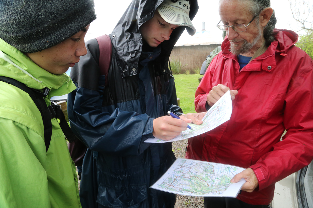
The torrent of rain subsided to a dull roar, so we took the opportunity to hop outside with our maps and compass.
Using a map of the farm, we first identified our current position. Purcell gave us the coordinates of a location just 500m away and told us to find our way there. The first step was to line up our current location and destination point, using the edge of the compass’s baseplate. Holding the baseplate still, we were then instructed to spin the adjustable dial on the compass so the orienting lines were parallel to the north/south eastings on the map. Then, keeping the bearing of the compass where it is, we took away the map, and spun ourselves so the magnetic needle pointed to 22 degrees, which is the magnetic variation for north in New Zealand. Keeping the magnetic needle pointed at 22 degrees, we picked a physical point that lined up with our direction of travel arrow (a tree, rock or other feature in your line of sight), and made our way to that point. Once there, we then picked another point in the path of the direction of travel arrow, and repeated the process until we reached our destination.
To further practice our newly-acquired navigation skills, we were split into three groups and given the coordinates for another yurt; this one hidden deeper in the bush.
Purcell made it a contest to see who could find the yurt first, so each group set out with a fervor that sent us sliding down muddy embankments, crashing through bush, and getting thoroughly soaked.
Our group of five followed the lead of Thomas Hoffart, who was particularly confident with his navigation skills. Down one hill and up the next we went, ignoring tracks and instead relying on the bearing we established before setting out.
After roughly 15 minutes of bush-bashing, we found ourselves back on an established track, with a very steep embankment posing an unappealing climb. Momentarily thrown off course, we recalculated our path, and again set off towards our previous bearing. We crossed a small stream and eventually sidled around one last hill before Hoffart spotted a clearing that could only mean one thing: we’d found the yurt, just moments before the second group arrived.
As a complete newbie to navigation, I was impressed by our success. I’ll admit that I wasn’t too convinced of our methods whilst bushwhacking, but with a constant bearing and repositioning, we found the yurt, albeit with a somewhat meandering path.
First aid
The rest of the afternoon was spent discussing basic first aid. Purcell taught us how to treat burns, and how to recognise the early stages of hypothermia. He said hypothermic individuals should be warmed slowly, and be given a warm, sugary drink if possible.
The debrief
A bushcraft course is important for all trampers, Purcell stressed. “You don’t know what you don’t know, and that can kill you. We told the students about a couple of the specific instances where people have either not known, or been inexperienced, or pushed themselves too far, and they don’t come back.
“It was a bit of a miserable day because of the weather, but in the outdoors you have to expect bad weather.”
Loretta Knights, another course participant, was all smiles after the course. As a member of the New Zealand Cadet Forces, she’s no stranger to tough outdoor training, and was happy to spend a couple of days learning bushcraft basics.
“I just wanted to get out there, be outdoors and get down and dirty. It’s such a good experience,” she said.
Purcell’s parting words for the students was encouraging but frank.
“You don’t know it all, yet,” he stated, “but by the time you‘ve done a couple of journeys, you’re going to know a lot more because you’re going to put into practice what we’ve been talking about the past two days.”
Indeed, the best way to learn is to get out there and amongst it.


