


- Area
- Dunedin
- Distance
- 6.23km
- Time
- 2.5-3 hours
- Grade
- Easy
- Access
- Signposted on Highcliff Rd, which runs along the spine of Otago Peninsula
- Map
- CE17
- Notes & Map
- Harbour Cone, Dunedin (pdf, 968 KB)
- GPX File
- Harbour cone Dunedin (gpx, yo 25 KB)
- Your device does not support GPX files. Please try a different device.
The purchase by the Dunedin City Council of a 328ha farm surrounding the visually impressive Harbour Cone has given a boost to walking opportunities on Otago Peninsula. This circular route takes in some of the best eh area has to offer.
Leaving from a sign on Highcliff Rd, 3km past the Pukehiki church, descend into Smith Creek, following marker poles. The route soon splits, with the left hand option dropping a little further before slogging up 140m towards Camp Road. It then sidles towards the ruins of Larnach’s model farm and carries on to join Camp Road.
Apparently, Larnach used this farm to experiment with some innovative farm practices. From here, those with time and a few dollars in their pockets can wander over to Larnach Castle.
Larnach’s self-deprecating name for his mansion was the Camp, hence the road name. It’s also possible to drop down the unformed portion of the road to the harbour side village of Broad Bay, where you can visit the first house built by the first Sir James Fletcher, on his way to building an empire, and then follow Portobello Rd to rejoin the tracks at Bacon St in Turnbull Bay.
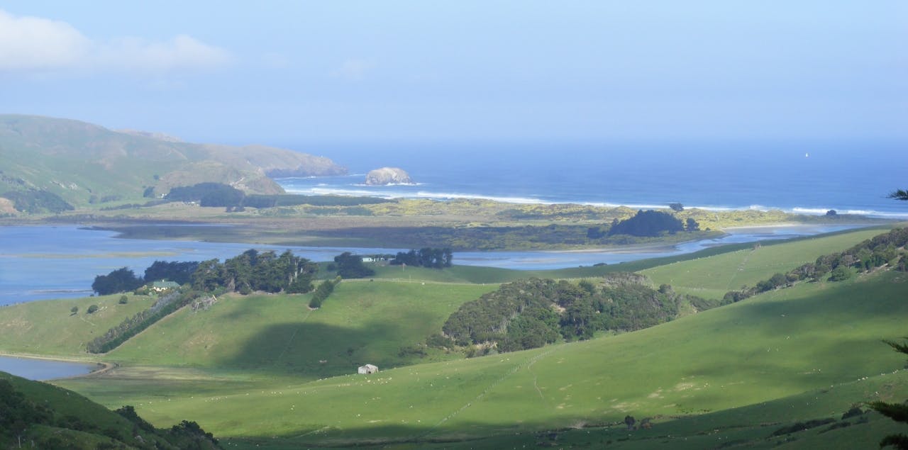
However, for this route, retrace your steps to Smiths Creek. The views on this section are outstanding and justify the detour. With Harbour Cone straight ahead, Aramoana and the mouth of Otago Harbour to the left, and Hoopers Inlet and the peninsula,s seaward beaches to the right.
Twenty years ago, veteran recreational activist Bruce Mason led a cunning campaign that pushed the Dunedin City Council to mark walking routes on nearly 20 unformed legal roads. These hidden treasures now form a useful track network.
Crossing Highcliff Rd, take the marked route that leads directly to the summit of Harbour Cone. If Bacon St Track has exhausted you, it,s possible to walk along the road for a bit over a kilometre back to your car, although a better option is to rejoin the tracks at a sign nearly halfway there and take the short climb to a ridge top with great views on the coastal side.
For years, Harbour Cone, a landmark featured in paintings by Grahame Sydney and Robin White amongst others, has been off limits to walkers. The summit boulder fields and the shape are reminders of its origins as a volcanic cone, an offshoot of the volcano that formed the peninsula and harbour.
Descending the steep legal road track that leads to Hoopers Inlet. It’s got a fixed rope at one point, and its only redeeming feature is that it used to provide the only public access between a couple of nice spots. The council’s purchase means that an alternative and more pleasant route now arcs around the side of a gully.
