The word ‘bog’ evokes ideas of a wet, dark and uninviting place. And Bog Inn Hut doesn’t sound entirely comfortable. But I had been wanting to visit this rustic hut close to Taupo for a while, and, to add more dankness to the whole trip, I chose to do it on a weekend near the shortest day of the year.
The 7km access road to Waihora Lagoon car park is signposted from Western Bays Road (SH32), west of Lake Taupo, and is in relatively good condition. Waihora
Lagoon sits on a short track from the car park and is well worth the detour. When we visited, the viewing platform was under water.
Starting near the car park, the Waihora Track follows an old logging road for the first 45 minutes or so, ending in a steep down-and-up-again section to cross a stream. Following this, markers are scarce but the track is not too difficult to follow. After a further 45 minutes an old wooden sign is reached that marks the intersection with the Hauhungaroa Track, most of which forms part of the Te Araroa Trail and is therefore well marked. The arrow pointing to the left indicates
Waihaha Hut, which can be reached in about four hours. The arrow pointing to the right indicates Weraroa (1088m) and beyond this is Bog Inn Hut.
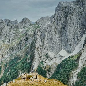
Heading towards Weraroa, we truly entered the ‘bearded forest’ that I associate with Pureora Forest. A thick layer of mosses, ferns and lichens covers nearly every surface, turning the landscape an intense dark green, made even darker in the gloom of an overcast day. The track is muddy in places and undulates for a time, crossing a few streams and passing by a sizeable wetland.

We stopped for lunch just before a short and sharp climb to Weraroa. As altitude is gained, the trees get smaller and the beards grow longer. The trig is a simple steel pipe rammed into the ground. There are no views from the summit because it falls just short of clearing the bushline. From here, the trail turns sharply to the north, and it’s a gradual and mostly uneventful trip down a broad ridge to a final intersection.
The Bog Inn Track links the road and the hut of the same name. Road access to the track is no longer permitted, but the trail is still marked to it. The intersection with the Hauhungaroa Track is not obvious and not signed, and care must be taken not to take a wrong turn. The hut is a further 15 minutes down the track.
Bog Inn Hut was built in 1960 by New Zealand Forest Research Institute scientists studying the nearby wetland known as ‘The Bog’. It was made by hand using timber harvested on-site. It still boasts the original walls, floorboards and roofing supports. In later years, DOC clad the exterior and roof with corrugated iron and added a wood burner, but a stay at the Bog Inn is still a draughty affair.
For those with alternate transport, it would be possible to walk north along the Timber Trail heading to Pureora (19km, 6-7hr), or to summit and traverse Mt
Pureora to Link Road (4hr). Since we only had one car, we opted to stay two nights at Bog Inn Hut, exploring the surrounds, the bog, and the flanks of Mt Pureora before returning to our car the way we came.
View all photos from this trip…


34 years of inspiring New Zealanders to explore the outdoors. Don’t miss out — subscribe today.

Questions? Contact us