


Every national park has its star attractions – the box office draw cards. Yet New Zealand’s 14 national parks combined cover an area the size of Otago and within that space hide scores of gems only those in the know will have enjoyed. And no-one is more in the know than a national park ranger. Matthew Pike gets to share a few of their best kept secrets….
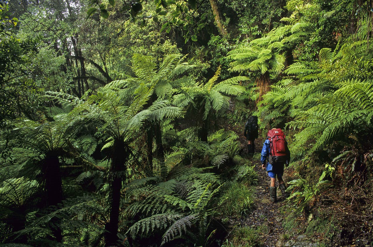
Nelson Lakes National Park
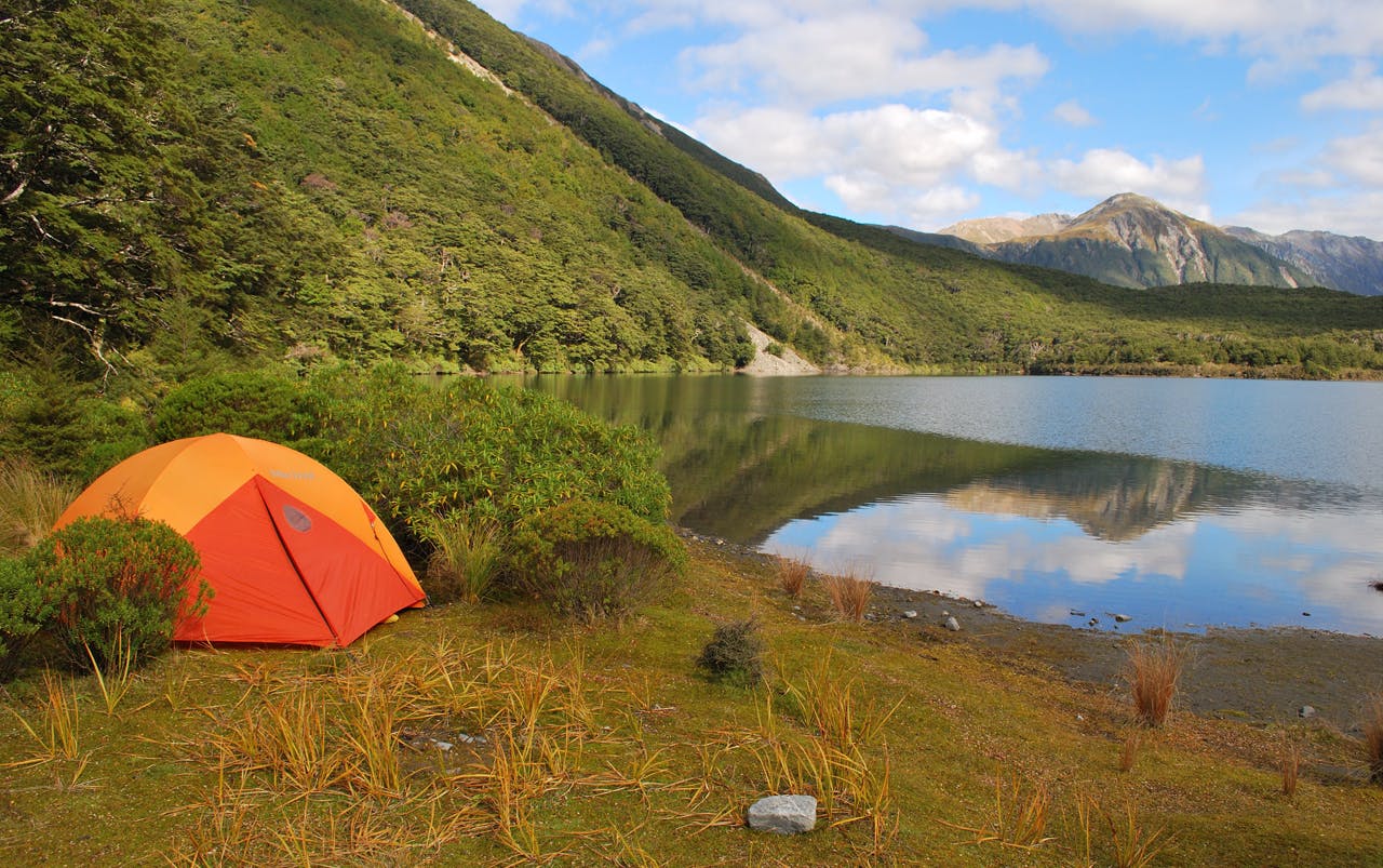
The secret: Hopeless Hut
Shared by: Kerry Parker, DOC ranger
“Hey hey! Now this is where it gets interesting,” said Kerry, his face beaming like a toddler looking at candy floss.
I looked around, knowing I should be amazed at something but struggling to work out what. We were in forest, though we had been since we set off, and the trees had become noticeably smaller since we gained altitude.
Kerry rushed over to a small silver beech. “These trees replace the big red beech trees at the valley floor. When we see these we know we’re getting to the good stuff.”
He motored on. I followed. I trusted his enthusiasm. Kerry Parker spends every working day maintaining tracks in Nelson Lakes National Park. Whether it’s a well-graded family-friendly loop walk or a remote alpine route connected only by cairns he’s been there, experienced it, improved it and loved it. He can’t get enough of it. When he’s not working in the park he’s there fitness training or enjoying a weekend in a hut with friends.
So when Kerry tells me we’re getting to the good stuff I believe him. I’d asked him to show me one of the best secrets in the park. And he was taking me up Hopeless Valley, alongside Hopeless Creek and heading to Hopeless Hut. The names don’t conjure images of grandeur and beauty. And on the map the route appears to lead to a dead end. A hopeless adventure perhaps? Certainly not a useful deviation for someone attempting the popular Travers-Sabine Circuit or heading for Angelus Hut. Needless to say the masses give it a wide berth.
“That’s part of the appeal,” said Kerry, springing from rock to rock. An avalanche path gives a taster of what’s to come, for it offers an opening in the trees which allows us to gawp at some of the rocky summits far above our heads. The hillsides on either side of the valley are so steep that there’s not much room for the sky in between.
Further up the valley the babbling water of Hopeless Creek disappears. You don’t notice until the stream is crossed. In one particularly dark section of forest the boulders of the dry riverbed are covered in an electric green moss that looks startlingly bright even in the shade. “I love this spot,” said Kerry. “When the sun’s shining that green looks incredible. Just don’t tell film maker Peter Jackson about it!” The water re-appears shortly after and it’s not long until the hut is reached.
Hopeless Hut is no oil painting. But it has history and the surroundings on its side. From the window you can see the result of an enormous avalanche – scree spewed from high right down to the creek in front of the hut (it is said to be the largest avalanche path in the country). Above this is a series of summits, each with their own procession of irregular rocky turrets. It’s as if you’re surrounded by 2000m-high unsurpassable fortresses.
And it’s this location Kerry is keen to share. “When I sit in this hut I feel like a small dot looking straight up at these huge mountains. I’m always trying to work out routes to the top and imagining what it’s like up there.
“Cupola Hut in the next valley across is surrounded by similar landscape, and that hut’s above the tree line. Both have extraordinary mountains towering above and both are off the main tracks so people tend not to see them.”
Though Hopeless Hut is still among the trees it’s just a short walk up to the huge open basin at the valley head where Kerry and I explore one of the many rocky gullies that provide excellent scrambling. We’re halted half way up by an enormous boulder lodged in between the gully walls. But the point had been proven – this landscape is a playground and you could spend days up here trying different routes.
Kerry points to a ridge. “That’s the route over to Sunset Saddle,” he said. “It’s a tough route which takes you to Angelus Hut, if you fancied turning this into a round walk.”
Time was running short for us and we headed back to the hut. Kerry told me some of the history of Hopeless Hut over a cup of tea. It was opened by Sir Edmund Hillary in 1967. Rumour has it he nailed up the commemorative plaque while standing on the floor – a feat that can only be appreciated when you see how high it is.
And for Kerry, the fact that Hillary stayed here adds another layer of fascination to the hut. “I look up and wonder which peaks he would have climbed and which way he would have gone. I wonder which bed he slept in and whether he’d have got up in the middle of the night to tend to the fire.”
Kerry then browsed the visitors’ book to see who’d visited the hut recently. He recognised the first name he came to: ““He works for DOC. Nice to see him making the trip up here… Oh, and she works for DOC too, over in Blenheim… so does she… and he does too. It’s great that so many of us are heading up here.”
This quick glance through the visitors’ book spoke volumes. Those in the know come here whenever they can. But this little gem is virtually unknown outside those who know the park very well and perhaps a few lucky enough to have stumbled on it by chance.
Te Urewera National Park
The secret: Manuoha Track to Lake Waikareiti – a three-day moderate tramp
Shared by: Anton Pompey, DOC Ranger Aniwaniwa Field Centre Te Urewera for 10 years
Tramping the Lake Waikareiti. Photo: Shaun Barnett
“This is a beautiful walk which gives you some of the best views of this part of the country and takes you to Lake Waikareiti – my favourite spot in the national park.
“The first hour is a real gut buster, but once you’re on top of the ridgeline the trees change from dense forest to open, mossy, goblin-like forest. Unfortunately there are no goblins here but trampers who have walked the walk seemed to enjoy the strange and mystical atmosphere up there with the moss hanging off the trees – like a scene from Lord of the Rings.
“It takes 6-8 hours to get to the top of Manuoha – the highest point in the park. On a good day you can see Tongariro and Ruahepu, Hawke’s Bay and to the north, the sacred mountain of Maungapohatu.
“The next day to Sandy Bay Hut, at Lake Waikareiti, is even longer – 8-10hr – but at least it’s mostly downhill.
“For me, Sandy Bay Hut is the best place to be. There’s a lovely beach and you can walk out into the lake for up to 100m before it reaches head height – it’s an awesome swimming spot. The water is so pristine and clear which also produces some good trout fishing for those who are keen and patient enough.
“Sandy Bay Hut can also be accessed from Aniwaniwa. It’s a short, sharp one-hour hike uphill to Lake Waikareiti where you can hire a rowing boat (prearranged at Aniwaniwa Visitor Centre). The boats are stored up at the Lake Waikareiti shelter and it is approximately a two-hour row to Sandy Bay Hut situated at the other side of the lake. You can visit one island on the lake – Rahui – where there’s a lake sitting on top of it. People like to see a lake on an island in a lake.”
Access: Aniwaniwa Visitor Centre at the northern end of SH38. Anton recommends parking your vehicle at the visitor centre (for security reasons) and taking a shuttle from Waikaremoana Motor Camp to the start of the track. For full shuttle service details, hire boat or hut bookings contact the Aniwaniwa Visitor Centre on (06) 8373803.
Tongariro National Park
The secret: Staying at the Oturere hut
Shared by: Jimmy Johnson, DOC ranger in the park for 21 years
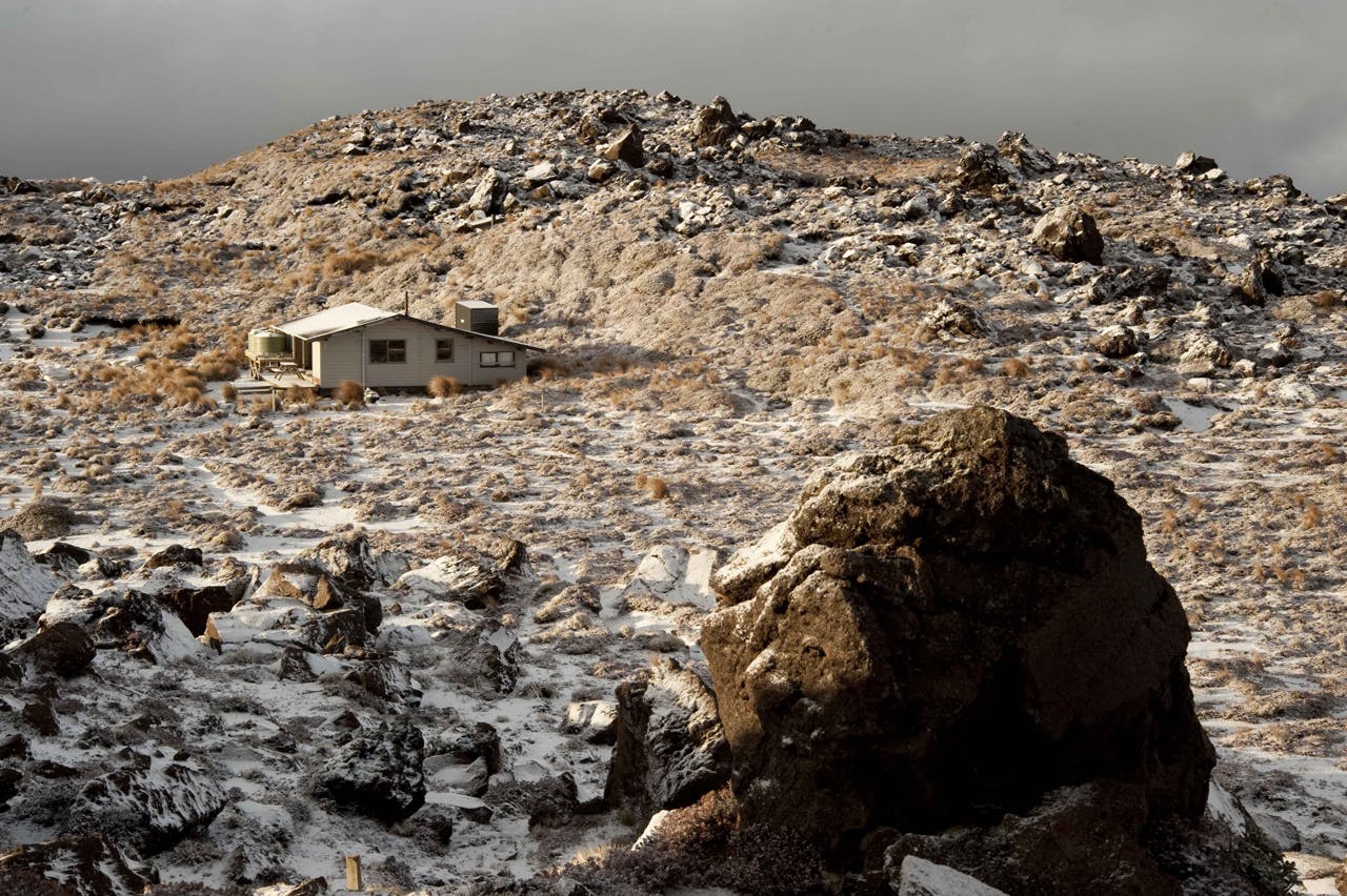
Oturere Hut is the quietest on the Northern Circuit and a base to explore the surrounding area from. Photo: Shaun Barnett
“Many walk through Oturere Valley but very few explore its assets. It’s covered with lava flows from thousands of years ago and walking through the weird lumps of jagged lava is a unique experience. “There are excellent views all around from the valley as far as the Kaimanawa Range to the east. “There is also a wonderful babbling stream running through which feeds the Oturere waterfall.
“The hut is the quietest on the Northern Circuit – people tend to cruise past either from or to Waihohonu. Yet staying there overnight gives you the best sunrises in the park during the summer season. A short 40m walk to the north provides fantastic sunrises across the Desert Road over the Kaimanawa Range. You can also see as far north as Putauaki (Mt Edgecumbe).
“A tip when waiting for the sun to come up is to turn around and look at Ngauruhoe, it gets the sun before you can see it. At the end of the day an easy walk up onto the ridge behind the hut gives excellent sunsets over Ruapehu.
“Stopping at the hut also gives you the chance to see the Oturere Waterfall – a short walk to the edge of the gorge in front of the hut offers great views of it.”
Access: On the Tongariro Northern Circuit between Emerald Lakes and Waihohonu Hut (off SH1).
Egmont National Park
The secret: The rough high country to the west of Mt Egmont/Taranaki
Shared by: Dave Rogers, DOC ranger for 36 years
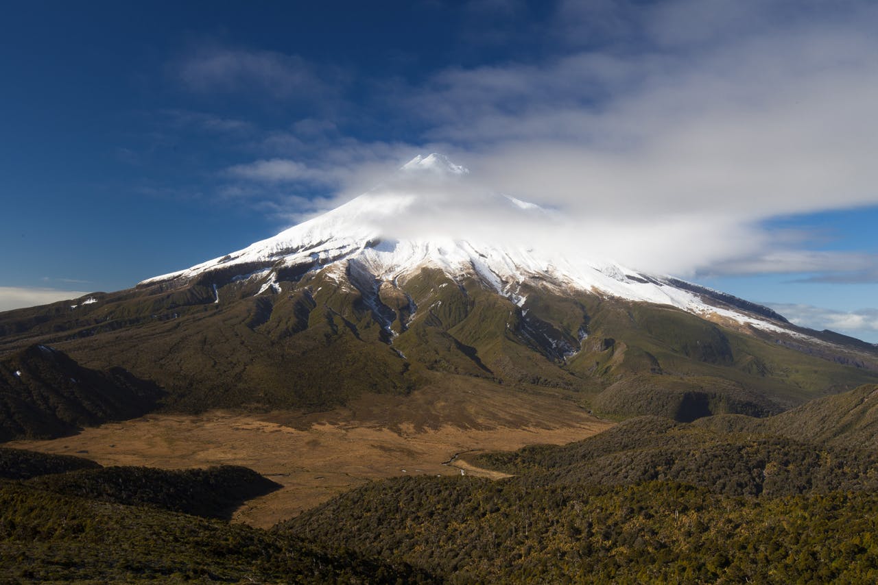
The sub alpine slopes on the western side of Mt Egmont/Taranaki are ‘magic’. Photo: Mark Watson
“I’d really recommend the rough country high up on the western side of the mountain. It’s not easy to get to because the section is susceptible to mass erosion but you can still get up there.
“It’s magic up high in the sub-alpine slopes once you clear the forest. You get great views of the unusual shapes of this weathered and sculpted region of the mountain.
“Exposed rocky ridges are high above and the shingle beds and scree slopes are very impressive.
“Fanthams Peak area and Bob’s Knob to the south west are particularly good spots to explore, as are the pyramids to the north west. And you often see great sunsets from up at this altitude.
“The Round the Mountain track used to reach this level but several years ago we had to close the section and lower it to forest level because of landslides. Because of this it’s steep in places and not many people tend to head up there. But it’s a great day walk – from the end of Kahui Road it’s about three hours up. It’s good to catch the sunset so bring your torch and leave the upper slopes until late afternoon.
“If you want to stay overnight there’s Syme Hut at the top of Fanthams Peak or Kahui Hut at the tree line.”
Access: A three hour walk to the alpine region from the end of Kahui Road.
Whanganui National Park
The secret: Matemateaonga Track, a three-day easy tramp
Shared by: Myles Gembitsky, DOC ranger at the park for more than 30 years
: Matemateaonga Track is often referred to as the milford track of the North Island. Photo: Shaun Barnett
“This track’s often referred to as the Milford Track of the North Island but is very underrated. There are some great views along the way, and you can incorporate a canoe journey or jet boat ride on the Whanganui River to begin or finish the walk.
“The tramp is pretty flat but the surrounding landscape is wild and rugged. The walk follows an old road built along a ridge in the early 1900s and features amazing birdlife and some lovely huts.
“You can often hear kiwi at night and you’ve a good chance of seeing robins, whiteheads and kakariki.
“Pouri Hut is a particularly amazing place to stay. In the mornings and evenings you can often see mist gathering in the distance with hill tops poking out above.
“Mount Humphreys is also a worthwhile detour – it’s a tough hike but once at the top you get stunning views of Whanganui, Egmont and Tongariro national parks.
“If you’re canoeing the Whanganui I’d really recommend the eastern end of this track as a day trip. You can leave your canoes by the river and head up to Puketotara Hut. It’s a bit of a climb and will take 1-2 hours but you get the kind of views of the river, Tieke Kainga and the surrounding landscape that you don’t get when you’re on the water. The hut’s a good spot for a picnic too.”
Access: From the Taranaki side, take SH43 from Stratford to Strathmore. Then turn right along Brewer Road and right again along Upper Mangaehu Road, parking at Kohi Saddle. From the Whanganui River side arrange a canoe trip or a jet boat ride from Pipiriki.
Abel Tasman National Park
The secret: The Gorge Creek, a half-day hike
Shared by: Greg Napp, ranger at the park for 18 years
The Gorge creek offers some of the best scenery in Abel Tasman National Park. Photo: Jiri Nehyba
“A truly spectacular walk is down The Gorge Creek, which flows out of Harwoods Hole, near East Takaka.
“The landscape here is mind-blowing – the most spectacular in Abel Tasman National Park in my opinion. It’s only a half day hike but you feel a million miles away from it all.
“The valley is deep with plenty of steep bluffs and rocky outcrops. There’s no track so you’ll need to be confident with navigation and have a reasonable level of fitness.
“There are a few river crossings with the water up to your thighs but the whole route is reasonably accessible so you won’t need any special gear to complete it. The best time to go is in summer when it’s not so slippery and the water levels are lower.
“Start from the Rameka Track – a popular mountain bike route – then head down through some bush to the creek. You want to hit the creek a few hundred metres down from the top.
“It’s normally dry here and it’s a bit like walking down steps. But at the resurgence you go instantly from no water to good creek flow and it’s just below here that you have your two deepest crossings.
“The water then becomes shallower as it disappears into holes at the side of the creek and, by the time you reach East Takaka Road, it’s normally dry again.”
Access: Park at Harwoods Hole car park off SH60.
Kahurangi National Park
The secret: Sand lava rock formations, Kahurangi Keepers Hut
Shared by: Mal Hansen, who has worked in the region for more than 40 years
Sand lava rock formations
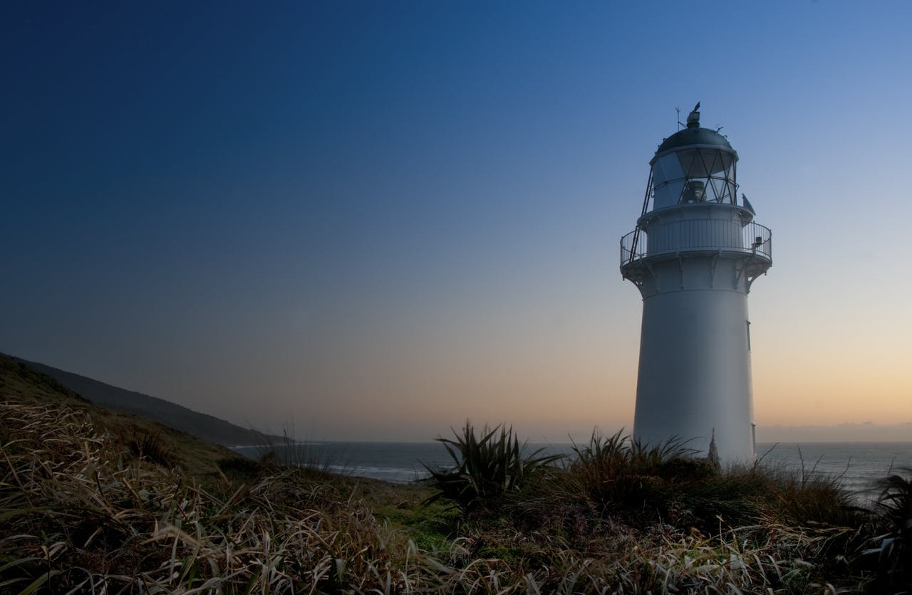
An end of the world feel at Kahurangi Point Lighthouse. Photo: Raymond Salisbury
“This is limestone that has eroded to form all sorts of odd shapes. The sand does actually look like lava and is formed by water running off the dunes. There’s a lighthouse here that has a great history to it and, nearby, is the old light keeper’s house, which is now a DOC hut.
“It’s a very special piece of coastline – I once spent a week here and got it all to myself. At certain times of the year there’s no-one there. To the south it has reverted back to native bush.
“Next to the hut there’s a bay which, at low tide, is great for swimming. At high tide the sea water forms a shallow lagoon which is also great for swimming, especially in summer when the sun warms the water up.
”You need to be careful on the way to the sand lava rocks. There are two rivers which can be dangerous if you cross at the wrong place, at high tide or after high rainfall. Anaweka River needs to be crossed at the beach, but with Big River you normally need to head up the estuary. Make sure you check tide times before you go.”
Access: Turn left at Seaford up Pakawau Bush Road. Follow round to the left, where it becomes Dry Road. Then continue along Cowin Road and park at the car park at Anatori. It’s a two-hour tramp to the sand lava rock formations and lighthouse. It passes through private property. Speak to the Takaka DOC office for permission.
Paparoa
The secret: Cave Creek Resurgence and Taurus Major Submergence
Shared by: Robin Reid, recently retired ranger of 33 years
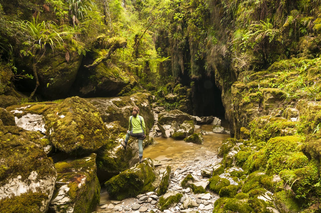
Cave creek with massive, moss covered rocks near Punakaiki and hiker. Photo: Petr Hlavacek
“This is a fascinating landmark where people tend not to go after the horrific accident there (a viewing platform collapsed in 1995, killing 14). But since then, the track there has been well looked after and it’s a marvellous example of geology.
“The 6km drive up the rough Bullock Creek Road from SH6 is a great experience in itself. If you park at the farm gate and continue walking up the track you soon meet a junction of tracks. Head left and you’ll see Bullock Creek captured by the cave system. The water disappears into the Taurus Major Submergence.
“Then, if you head back past the junction you’ll see the water re-emerge at the Cave Creek Resurgence. It’s a real spectacle and it’s so easy to reach. The tracks are well maintained and it takes no more than an hour to get there.
“There’s more to this region than Pancake Rocks and the resurgence is a must-see.”
Access: Park at end of Bullock Creek Road (prone to flooding) and two-three hour easy return walk.
Arthur’s Pass National Park
The secret: Lake Minchin
Shared by: Chris Stewart, who has worked in the park for four years and has walked in the area for 40 years
Lake Minchin is a perfect, quiet, place to camp. Photo: Matt Gwynne
“A beautiful lake set right in the mountains at the head of the Poulter Valley. It takes two days to get to it from the Mt White Road, with an overnight stay at Casey Hut next to the Poulter River recommended.
“Casey Hut is a popular destination but not many people take the extra half day to get to Lake Minchin, which is a shame because it’s such a perfect spot and a great place to camp.
“The lake takes you by surprise as you tramp up the Minchin Stream from the Poulter River junction. It looks spectacular with the surrounding beech forest. Mountains include the Snow Cup Range and Mt Scarface. There are good camping spots at either end of the lake and good fishing in the lake.
“The walk in is relatively easy with well-marked tracks to Casey Hut and on to Lake Minchin. Beyond the lake, trampers can cross Minchin Pass to the Taramakau River. This was used as a route over to the West Coast, but it’s tough and requires a bit more experience.”
Access: Start at the Poulter River junction on Mt White Road (off SH73). Moderate tramp which you need at least three days to complete.
Westland Tai Poutini National Park
The secret: Okarito Lagoon
Shared by: Sarah-Jane Luoni, DOC’s community relations ranger
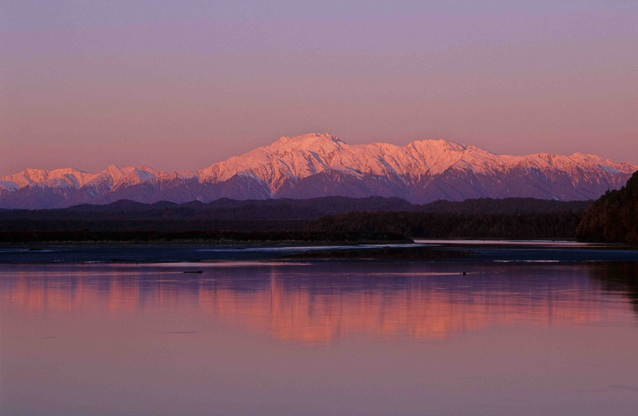
Views of the Alps from Okarito Lagoon. Photo: Steve Baker
“The lagoon is best explored by kayak or boat and offers amazing birdlife and gorgeous views. It’s a feeding ground for many species, the kotuku (or white heron) is a common sight, as are royal spoonbills, shags, stilts and, during summer, the eastern bar tailed godwit.
“Low tide, when the mudflats are exposed, is the best time to see birds out feeding. Fern birds and bitterns are about and are occasionally seen by keen eyes around the edges of the wetland.
“There are also a couple of must-do walks in the area, too. The Okarito Trig and the Three Mile lagoon walk, or just a wander along the beach here is beautiful. If you sit quietly atop the Okarito Trig Track at dusk you have a chance of hearing rowi – New Zealand’s rarest kiwi species.
“A self-guided kayak trail across the lagoon has also just opened. It’s 7km long and is well worth exploring.
“DOC looks after the Okarito School house which can sleep up to 12 people. There is also an excellent campground which is run by the community association.
“Okarito is beautiful whatever the weather. On a clear day the views are amazing, but it can be just as much fun to layer up and head out into the elements on a wild West Coast day.”
Access: The lagoon is next to the town of Okarito, with a turn-off between Franz Josef Glacier and Whataroa.
Aoraki/Mount Cook National Park
The secret: Wakefield Ridge
Shared by: Ray Bellringer, community relations ranger
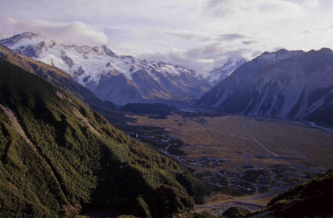
Mt Cook Village with Wakefiled Ridge on the right. Photo: Shaun Barnett
“This is the eastern end of the Mount Cook Range so if you keep going you could eventually reach Aoraki/Mount Cook!
“It’s a great way to get panoramic views without needing crampons and an ice axe. There’s nothing technical or steep here – just a great day trip for tramping types.
“The stunning views include Sefton, Hooker Glacier and Copland Pass to the west, the south face of Aoraki and the Hillary Ridge to the north and the Tasman Valley, Nuns Veil and the upper Tasman Glacier to the north-east.
“There is a reasonably well formed track but it is considered a route. Go as far as you like within personal capability and return the same way. Note that Mt Wakefield itself is a deceptively long way along the ridge.
“The reason this route is not well known is because it’s not formal in any way – it doesn’t appear in DOC brochures or in any climbing guides.
“The only way visitors normally hear about this trip is by word of mouth or, having completed a number of local tracks over several days, return to our visitor centre looking for more of a challenge, in which case it is an option offered by visitor centre staff.”
Access: Tasman Valley Road, east of Mount Cook Village.
Mount Aspiring National Park
The secret: Upper Wilkin Valley
Shared by: Dave Grieve, ranger visitor assets
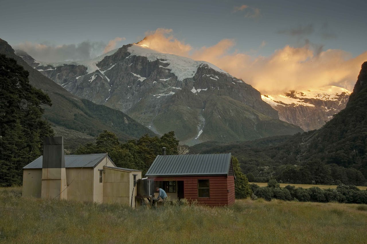
Top Forks Hut with dawn light on Mt Pollux. Photo: Shaun Barnett
“The remoteness and stunning scenery makes this area so special. The north branch with the alpine lakes Diana, Lucidus and Castalia are a draw card – and I’m more often than not treated to the sight of rock wrens and the New Zealand falcon.
“Spring is a great time to explore the area – you can swim in the lakes with icebergs! The area is suitable for day walkers, trampers or climbers – a great place to escape.
“Top Forks Huts at the forks of the North and South branches is an ideal place to base yourself in inclement weather although camping under rock bivvies near Lake Lucidus is my preference – they nestle in sub alpine vegetation.
“Lake Lucidus, a spectacular moraine lake, is 20 minutes away from Diana across the alpine meadows. Further up the north branch the track to Lake Castalia follows a snow grass terrace leading to the lake’s outlet. It’s an unspoilt mountain valley with huge waterfalls and awesome campsites that never disappoints.
“Trampers have a choice of two ‘Top Forks’ huts. One is a classic old deer culler’s hut that was milled out of local timber – you can still see the chainsaw cuts in the timber frames. With an open fire and six bunks this 52-year-old hut has real character. The adjacent newer hut has a slightly more modern feel with a wood burner stove and 10 bunks. Castor and Pollux – peaks of over 2500m – dominate the skyline from the hut.
“From the huts it’s a day walk to the lakes – the furthest being a three-hour hike – or you can explore the South Branch leading to the Rabbit Pass Route.”
Access: From Makarora, jet boat up the Wilkin River to Kerin Forks then it’s a six-hour hike to the hut or you can fly into the Jumboland airstrip, from which it’s a one-hour hike to the hut
Fiordland National Park
The secret: Mt Memphis Tarns
Shared by: Pania Dalley, DOC’s operations ranger for the past eight years
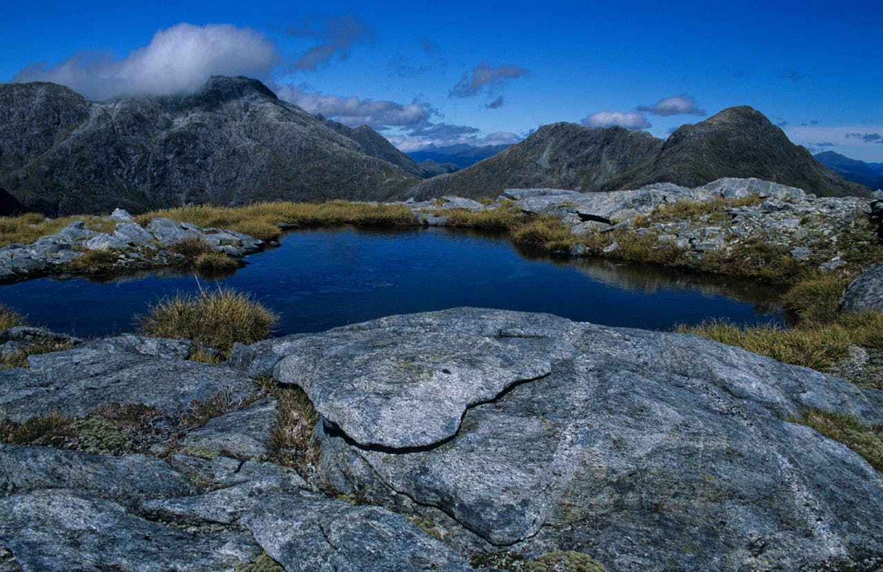
Memphis tarns are easily reached from the Dusky Track. Photo: Shaun Barnett
“If you’re tramping the Dusky Track you don’t want to miss this detour. It’s only an hour or two up from Centre Pass but is the sort of place you want to stay for a while.
“A lot of the Dusky Track is through old deer stalking country in forest on the valley floor. But if you miss the track up to the tarns you’re missing a major attraction. The climb gets you above the bushline and suddenly Fiordland opens up in front of you.
“You have a great choice of tarns (though the water’s often very cold!); some are 50m across and 10m deep, others are like bath tubs.
“And the great thing is you can easily reach this spot in a weekend trip. You can get to Upper Spey Hut by the first afternoon. Then you can head up the mountain that day if you have time, or leave Upper Spey Hut early in the morning to arrive at the tarns by lunchtime.
“The Dusky Track is a really wild, remote track. The whole area here is just stunning and is worth a few days even if you don’t plan to complete the whole track. You start with a boat trip across the Manapouri which is beautiful, and bus drivers will carry you for 10 minutes to the start of the track. Then you’re straight into the Spey Valley with the yellowbirds, kea and kiwi.”
Access: Two-hour climb from Centre Pass on Dusky Track.
Rakiura National Park
The secret: Doughboy Bay
Shared by: Sharon Pasco, who has worked on the island since the early 1980s
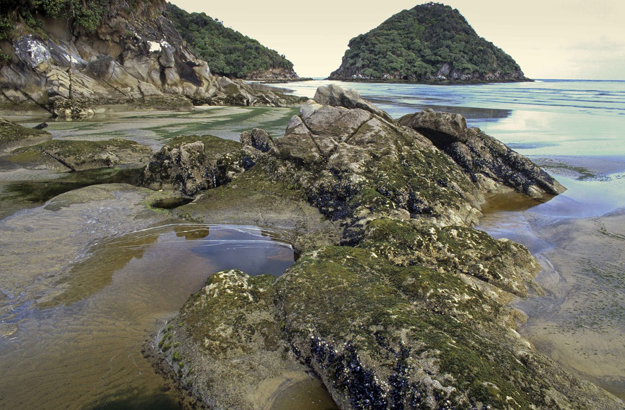
Low tide, Doughboy Bay, Rakiura National Park, Stewart Island
“This is a special place for me. It’s a remote, exposed sandy beach with huge waves and is one of the best places for spotting kiwi. In fact, kiwi often come down to the beach in the evening to flick among the kelp. I’ve lain on the beach before and had kiwi come and peck at me. If you don’t move they probably won’t notice you’re there.
“There’s an old hut on the beach and a small cave that’s a good spot for camping. At the northern end there’s a point that’s good for fishing and you feel like you’re at the edge of the world. There’s not much beyond!
“DOC has spent a lot of time controlling the marram on the dunes and re-introducing pingao. This gives the dunes a nice reddy glow that’s particularly beautiful in early evening light. There’s also the chance to see penguins, white tail deer and the occasional sea lion.
“People incorporate the beach into the southern circuit and when you reach Doughboy it’s best to stay a couple of nights to really enjoy it. Whether you head from Mason Bay or from Rakeahua Hut, you’ll head through a variety of eco-systems with beautiful forest and semi-alpine plants.
“The whole of the west coast is special and I’d thoroughly recommend a tramp from Christmas Bay Village, round the north of the island and down the west coast to Doughboy. You need a few days but the feeling of seclusion is unbeatable. There are also examples of where man has tried to shape the environment, but in the end the environment won.
“In the 1970s, a Japanese lady who loved Doughboy Bay marched over there from Halfmoon Bay towing a wheeled suitcase behind her. She wanted to live there but in the end the authorities had to take her away. She did well lugging that thing across the island because it’s pretty muddy!
“To tramp to Doughboy you need to be experienced, fit and prepared with extra supplies in case the weather closes in and you become stranded for a few days.”
Access: From Halfmoon Bay it’s a four-day difficult tramp to Doughboy or you can reach it via water taxi or helicopter.
