Image of the February 2015 Wilderness Magazine Cover Read more from the
February 2015 Issue
Home / Articles / The Life List

50 best tramper’s peaks: mountains M-P

A party high on the north east ridge of Mt Manakau. Photo: Geoff Spearpoint

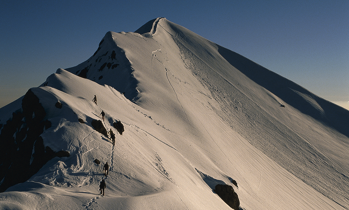
Mt Manakau, 2608m

Mt Manakau Scenic Reserve, Canterbury

The Kaikouras are a young and active range featuring fractured rock and a barren landscape. Yet these very features bring their own uniqueness and charm. The attractions begin with the access up the Hapuku Gorge, where high greywacke bluffs tower over the gravelly riverbed.

A sidle track leads through wonderful podocarp stands here, mainly totara. Beyond the gorge, follow the true left branch and climb up to Stace Saddle. Surveyor Spur keeps the climb honest, until, as you reach 2000m, the angle eases. Some camp in these upper basins, but water can be short in autumn.

From the saddle, scramble up the ridge, sidling pinnacles on the Clarence side if you need to. Some may like the support of a rope here. From the range crest, the Clarence country spreads out below, revealing the huge scale of the area. On the other side of the range, the Pacific Ocean rolls off to the horizon while the Kaikoura Peninsula spreads out like a map below. The views are fantastic, but Manakau is also memorable to me for another reason.

In 1971, when I was young and sillier, my school friend Lauchie and I made our first trip to climb the peak. We hitched a ride from Picton over a long weekend. The ascent proved straightforward, with fresh snow dusting the upper slopes.

Lauchie and I were never ones for retracing our steps, and it being mid-afternoon in late May, we decided to traverse to Mt Uwerau, a 2213m outlier to the south, to make a round trip of it. Part-way across we stopped in the dark at a rocky section to wait out the night. I have never experienced such cold.

We had no bivvy gear. My only clothes were shorts and a thin jersey under my windproofs. We lay huddled on the gravel in a tube of plastic as the frost crystals grew longer around us. For dinner we shared a tube of condensed milk. With over 12 hours’ darkness, all eternity passed that night.

With sunrise we continued our traverse and descended to the Hapuku. Not having water bottles on the climb, we then had our first drink in 27 hours.

I’ve been up Manakau a few times since, when it is mantled in winter snow, and camped high up. Great trips all, but not quite as memorable as the first time.

– Geoff Spearpoint

Time 2-3 days Grade Moderate

Mitre, 1571m

Tararua Forest Park, Wellington

The highest peak in the Tararuas can be reached from the Upper Waingara Road-end via Mitre Flats Hut. Head up through beech-podocarp forest and, on reaching the tree line, scramble up a rocky slope to Peggy’s Peak, then up to Mitre itself. Ruapehu, Mt Taranaki and Tapuae-o-Uenuku can all be seen from the summit on a clear day.

Time 12hr Grade Moderate

Mt Ngauruhoe is not your usual summit. Photo: Neil Silverwood

Mt Ngauruhoe is not your usual summit. Photo: Neil Silverwood

Mt Ngauruhoe, 2287m

Reader Neil Silverwood describes the summer and winter contrasts on Mt Ngauruhoe

Aside from its geological history, what makes Mt Ngauruhoe so special is the dramatic change in the landscape between summer and winter. Dry and barren in summer, its slopes are covered by loose scree. On a nice day it’s a straightforward climb. In winter, though, the mountain changes dramatically, its slopes blanketed by snow, ice and sastrugi and the climb becomes a serious challenge for trampers.

In both seasons, the best route begins from the southern edge of the South Crater then climbs directly up.

In summer, the climb is popular and achievable, though there is an inherent risk of rockfall. It takes about two hours to reach the top.

It’s not your usual summit. At the northern edge of the rim you look down into a massive crater. Often plumes of acidic smoke leach out from beneath rocks. Some areas have been undercut, leaving small caves behind. It’s an eerie scene. A place where one has the feeling of standing on top of a sleeping dragon that could stir to life at any moment.

During winter, the climb becomes a more difficult undertaking. Trampers will need to carry ice axes and crampons. The mountain often undergoes a melt-freeze cycle. Sun during the day melts the top layer of the snowpack, creating corn snow. Then at night it refreezes.

One great way to experience Ngauruhoe is to camp on the plateau east of the crater. The view of Mt Ruapehu and sunset is stunning. This is only an option in good weather as the top is extremely exposed. Water is also an issue, especially in autumn.

A summer tramp up Ngauruhoe is a cool way to get away from the crowds, while a winter ascent is challenging and something you will remember for a lifetime.

Time 4hr car park to crater Grade Moderate

Ohuinga, 1686m

Ruahine Forest Park, Hawke’s Bay

The approach to Ohuinga is what makes this trip a classic. Sawtooth Ridge is an infamous section of the Ruahine Range, named for its serrated profile when viewed from the east. While not an easy undertaking in the wrong weather, or in snow-plastered conditions, in summer it’s a reasonably straightforward tramp to traverse over its length, climbing Tiraha and Ohuinga en route.

The steepest section is probably approaching the summit of Ohuinga itself from Black Ridge, so it’s perhaps advisable for those who may be nervous of the exposure to do this in the uphill direction.

While the ridge crest of the main Sawtooth is indeed narrow, a well-worn trail sidles any small crags, and the footing is good. Tarn Biv or Howletts Hut make good places to spend a night, and in summer the area abounds with native flowers.

The approach to either hut up the Tukituki River requires normal river levels; it can become a difficult beast to ford when in high flow.

Time Ohuinga summit via Rosvalls Track, Tarn Biv and Black Ridge 6-8hr. Out via Sawtooth Ridge, Howletts Hut and Tukituki River 6-9hr Grade Moderate

Mt Owen, 1875m

Kahurangi National Park, Tasman

Climbing Kahurangi National Park’s highest summit is a unique experience due to the unusual karst landscape. Millions of years of intense pressure has turned the limestone rock into marble. Tramping over these giant slabs and jumping over rock crevasses becomes a major feature of the climb. Many climbers from the northern side stay at Granity Pass Hut, from which it’s a three-hour climb to the summit.

Time 2-3 days Grade Easy

Mt Ollivier stands high over Mueller Hut – a great sight after a steep climb from the valley. Photo: Mark Watson

Mt Ollivier stands high over Mueller Hut – a great sight after a steep climb from the valley. Photo: Mark Watson

Mt Ollivier, 1933m

Aoraki/Mt Cook National Park, Canterbury

For the classic view of New Zealand’s tallest mountain, take the popular route to Mueller Hut, via Sealy Tarns. The tarns mirror Aoraki and Sefton beautifully and the hut is like having a front-row seat. From there it’s just a 30min climb to the summit. The climb also rewards with great views of the dramatic ice falls on Mt Sefton and overlooking the Mueller Glacier as it winds its way towards Mt Burns.

Time 9hr Grade Moderate

Mt Patriarch, 1701m

Kahurangi National Park, Tasman

This fine peak is more often viewed than climbed, as its shapely wedge dominates the horizon to the north from Mt Owen.

Mt Patriarch has at least one advantage over its more popular neighbour: a perfect two or three-day round trip is possible, including a couple of classic old six-berth huts and there’s a real 1700m summit to climb along the way.

It was late one May when I finally got around to a trip on the north side of the Wangapeka.

Starting from Rolling Junction car park, the initial three hours followed the broad, well-maintained Wangapeka Track along the river.

At a footbridge over the main river, the Wangapeka is left behind and the well-graded, old miner’s track heads north alongside the lushly vegetated Kiwi Stream.

Kiwi Saddle Hut in a forest clearing at around the 1000m contour is a delightful place to overnight, complete with an open fireplace and views westward to the Mt Luna Range.

With the temperature outside dropping below zero, a glowing fire along with an after-dinner mug of port made this hut a home from home.

Morning arrived fine and frosty for the 700m climb to the top of Mt Patriarch. Steep in places, the track threads through a subalpine array of neinei and twisted tree daisy before reaching the bushline and open tussocklands above.

Dumping our heavy packs at the start of a side track to the summit, it took about 45min to reach the first, and highest, of the three tops.

At 1701m, there are extensive views in all directions over a large chunk of Kahurangi National Park. So many peaks and ranges to identify, but it is the sprawling massif of Mt Owen across the Wangapeka Valley that dominates the southern skyline.

Retracing our steps to our packs, we continued along open tops with the peaks of Baldy, Gomorrah and Sodom stretched out to the north-east.

Chummies Track lies at the eastern end of the Patriarch massif, with a steep descent through scrub to John Reid Hut. As the day was wearing thin, we settled down for a second night of ‘six-bunk luxury’, with a blazing fire soon completing the scene.

The following morning our knees felt the almost 1000m descent down Chummies Track back to the main river, which was easily forded in autumnal low-flow.

Time 2-3 days Grade Moderate

Trampers traverse Mt Philistine’s ridge with The Slide and Otira Face of Mt Rolleston creating a dramatic backdrop. Photo: Mark Watson

Trampers traverse Mt Philistine’s ridge with The Slide and Otira Face of Mt Rolleston creating a dramatic backdrop. Photo: Mark Watson

Mt Philistine, 1967m

Arthur’s Pass National Park, Canterbury

Mt Philistine is a neighbouring peak of Mt Rolleston and is a moderately challenging climb, particularly the access route to the upper basin and summit slopes through the bluffs.

The normal route heads up the Otira River Track, crosses on the footbridge and then heads directly up through scrub, scree and tussock to the high shoulder west of Warnocks Knob.

The bluffs are climbed from the west end of the shoulder, at their lowest point, to the basin above. A rough ground trail will be found and some cairns. Take special care not to stray too far to the north or south of the main route up, as very steep terrain awaits and there have been some fatalities here. In mist, or with snow and ice on the route, you should perhaps postpone the climb for a better day.

The summit view is spectacular, with grand views of Mt Rolleston and Westland. Take care again on the descent to find the exact spot at the top of the bluffs (marked by a cairn) to make a safe return.

Time 3hr Grade Difficult

Mt Pfeifer, 1704m

Arthur’s Pass National Park, West Coast

This peak is in a wonderful isolated corner of Westland wilderness that can be approached from near Otira.

Stand on the summit at sunset, watching the warmth of the evening sun strike the mountains surrounding the Otehake, bathing them with bold golden rays of intense light before the valleys plunged into darkness. Far below, rivers murmured in the depths.

The basin beneath Pfeifer has a relatively new bivvy, and as the dew fell we retreated to its warmth.

The peak is best approached from the Deception Swingbridge over the Otira and climbing up Paratu Stream to Waharoa Saddle where volunteers Frank and Honora have helped keep the marked route up to the tops usable. Cross east over the range at about 1480m and sidle across pleasant basins to the bivvy and up to the peak.

Time Two days Grade Moderate

Pirongia Mountain, 959m

Pirongia Forest Park

This forest-covered ancient volcano (activity ceased 2.5 million years ago) dominates the western-Waikato skyline and a viewing tower at the summit provides panoramic views over the district – even sighting Mt Taranaki on a good day.

The Tirohanga Track provides the most popular route to the top, becoming narrower as it gets higher, eventually climbing over great rocky tors.

The Link Track provides a good return trip and Pahautea Hut (20 bunks – due to be re-opened by early 2015) sits close to the summit.

Time 3-5hr to summit Grade Moderate

Pouakai, 1400m

Egmont National Park, Taranaki

An accessible year-round peak with spectacular views of Mt Taranaki. Many of the classic shots of its larger neighbour have been taken from the summit of Pouakai or thereabouts. Can be a day walk or overnighter, or part of the 2-3 day Pouakai Circuit.

Time 6-7hr Grade Moderate