
July: Cape Brett Hut, Northland
Many people might be thinking of an island escape at this time of year, but a far healthier and cheaper option is to head to the ‘winterless’ north where you can stay in one of the region’s few backcountry huts.
The launching point for this Northland track is Te Rawhiti, 30km from Russell. Many do the tramp in one of two ways; either walk in and get a water taxi back or taxi in and walk out – which is popular because you carry lighter packs due to having eaten your dinner before beginning the tramp. Budget trampers, or those made of harder stuff, will walk both ways.
In 1908, a lighthouse and three homes were built at the end of the cape, where a succession of lighthouse keepers’ families lived. The settlement was staffed until
1978 when an automated light was installed. DOC took over the management of the lighthouse in 2005.
The peninsula is co-managed by the Te Rawhiti 3B2 Trust, DOC, and Cape Brett Walkways and walkers must pay a fee of $30 ($15 for children) to walk the section to Deep Water Cove.
The walk covers 16km and while the trail is well-formed and easy to navigate, there are few stretches of level ground. It’s all up and down so there is not much advantage in choosing to walk in one direction or the other. Walking in, the scramble to the last high point before the end of the track is particularly steep, but the resulting first views of the lighthouse will provide the motivation to tumble down the final steps to the picturesque Cape Brett Hut.
The hut is sited just metres from the jagged cliffs of the cape’s final reaches and is full of the character you’d expect from a former lighthouse keeper’s home.
Hardwood floors line the interior and broad windows provide views to the sea.
The water taxi meets walkers near the hut (or Deep Water Cove in poor weather or large swells) and the boats will often tour the Hole in the Rock before heading back to Rawhiti.
Wild File
Access Rawhiti Road end
Grade Moderate
Time 6-8hr
August: Te Puia Lodge, Kaweka Forest Park
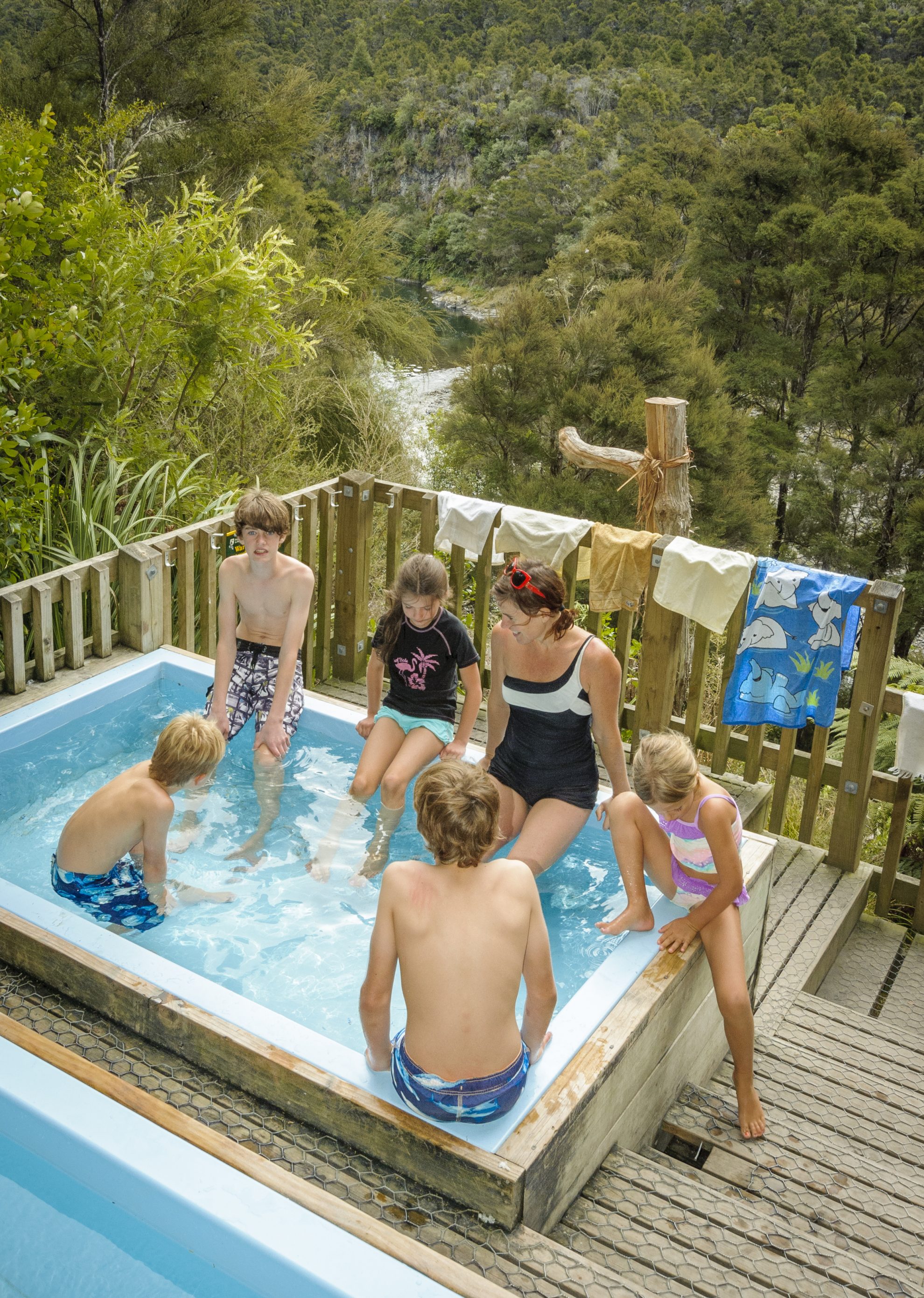
A large hut, a sizeable river, pleasant forest and natural hot springs – what more could you want? This easy tramp in Kaweka Forest Park is made for a luxurious weekend, and the hot springs are a real treat, especially during the winter. The best thing about the trip is the chance to soak in hot pools at the beginning and the end of each day’s tramp – something no other New Zealand walk offers.
From the car park and camping area at the end of Makahu Road, a five-minute walk leads to the well-developed Mangatutu Hot Springs, where two tubs are partially sunk into a wooden deck (note: keep your head above water to prevent any chance of contracting Amoebic meningitis). After a pleasant soak, you can begin your tramp up the Mohaka Valley feeling warmed and relaxed.
The Mohaka is one of the principal rivers of the Kaweka Range and is well known for its excellent trout fishing and rafting. Considering the rather precipitous nature of the valley, the track is generally easy, although it does have a couple of high sidles to avoid bluffs.
Te Puia Lodge is set on a flat near a substantial river bend. As the largest hut in Kaweka Forest Park, it’s naturally popular – although often quieter during winter. After a break at the hut, take the track up-valley, cross the Makino River on the footbridge, then sidle along to the
Mangatainoka Hot Springs, set in a clearing surrounded by rimu, matai and kahikatea, where it’s possible to camp. The natural hot springs here are piped into two tubs, with room for a dozen or so people. Soak until evening, and perhaps sup some wine as you listen to the ruru or even – if you’re lucky – a North Island Brown kiwi.
Wild file
Access ‘The Gums’ campsite and car park on Makahu Road
Grade Easy
Times To Te Puia Lodge, 2.5-3hr; To Mangatainoka Hot Springs 40-50min
– SB
September: Salisbury Lodge, Kahurangi National Park
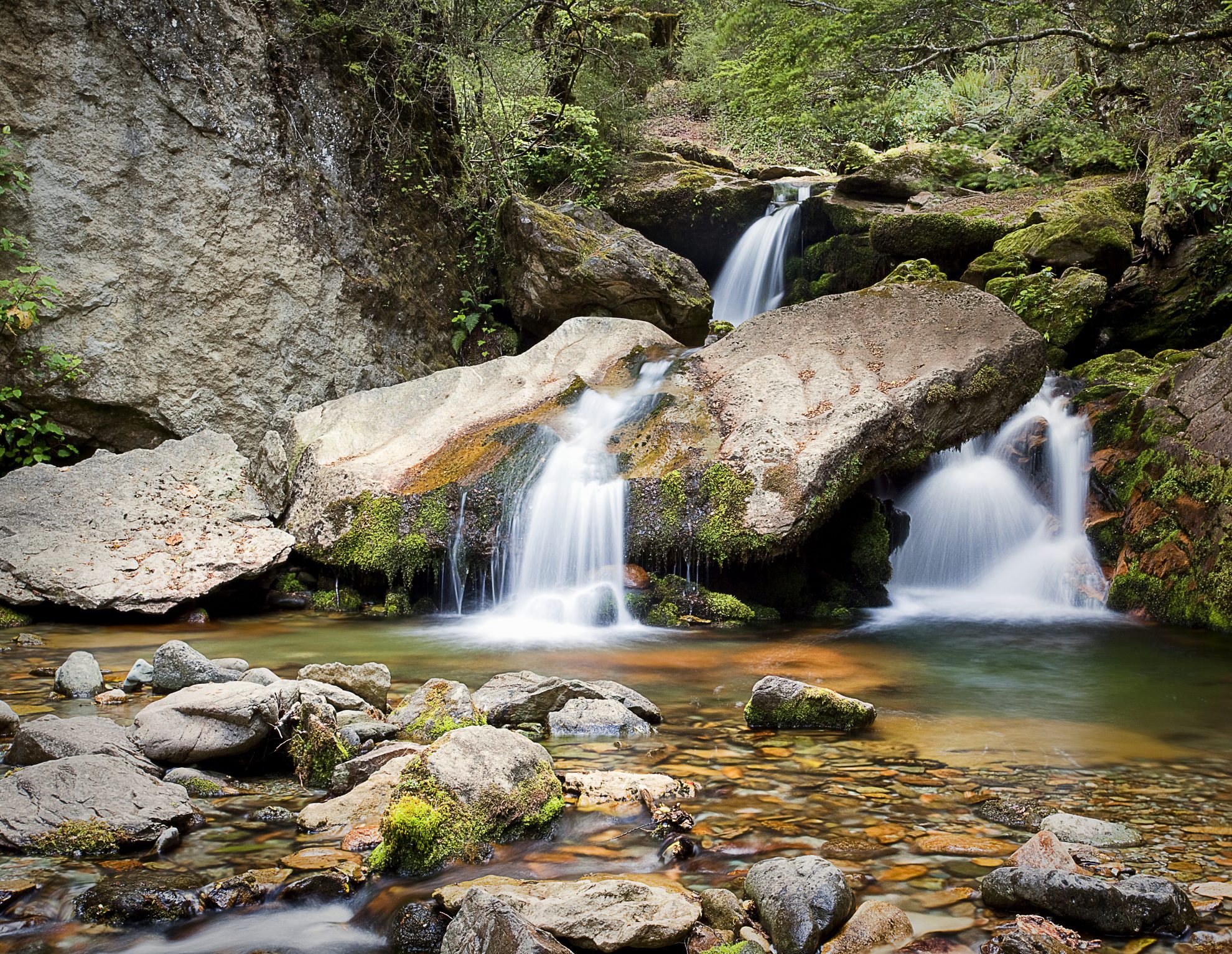
This easy jaunt behind Mt Arthur showcases the incredible biodiversity found in Kahurangi National Park. From the limestone escarpments above the country’s deepest cave systems to head-high tussock on the Tableland to lush native forest – it’s all here. There’s also a generous range of accommodation, from earthen rock shelters to prospector’s shanties to historic huts. It seems that the Tablelands are a veritable time capsule. And at the end of winter, you’ll have this primordial place all to yourself.
Setting off from Flora Saddle, skirt the flanks of Mt Arthur on a vehicle track that leads to the twin-roomed Flora Hut – the hut dates back to the 1920s when men and women had separate sleeping quarters.
Later, you’ll be enchanted by Gridiron Rock Shelters. Climb a steep trail to discover the quaint, corrugated-iron hut at Upper Gridiron, eclipsed by an overhanging rock. If you’re travelling with kids, you must overnight here and enjoy an evening around a blazing outdoor fire listening for kiwi.
The bulldozed road merges into a miner’s track, wide and well-worn. Look out for whistling whio in the Flora Stream. Push on through lush beech forest to emerge on to Salisbury Open, named after Thomas Salisbury who scouted the area in 1863 and found the first gold.
Further on, through tall tussock and stunted silver beech, is Salisbury Lodge. Spending a day here to explore the caves and mining relics of the Tableland is recommended.
For the fit, a day trip to climb Mt Peel; for the adventurous, an excursion southward to a few glowworm grottos, where graffiti on the walls dates to 1880; for the curious, an outing scouting Cundys Creek will give a glimpse into the jumbled geography of this much-loved landscape.
A return journey can be made over the rugged ridges of Gordons Pyramid to the potholed flanks of Mt Arthur. However, at this time of year snow and ice make this more difficult.
Wild File
Access Flora Saddle at the end of Graham
Valley Road
Grade Easy
Time 2-3 days. Car park to Salisbury Lodge, 4hr; To Mt Peel, 6hr return
– RS

October: Mavora Walkway, Southland
The magnificent Mavora Lakes is a landscape par excellence, resonating an archetype of New Zealand mountain scenery.
One of the best ways to see this region is on the Mavora Walkway which links the lakes to the lower Greenstone Valley. The walkway is also part of the Te Araroa Trail.
Over 3-4 days, the track follows the shore of North Mavora Lake and heads along the plains of the Mararoa River before entering mature red beech forest and following the Pass Burn to the Greenstone Valley. This is an easy tramp – the landscape is very forgiving, height gain is minimal and the track and vehicle trails are easy to follow – yet set amidst the fantastic landscape of the Livingstone and Thomson mountains there is space, grandeur and peace in abundance.
Although you can drive to North Mavora Lake, it is best to start at the swingbridge over the Mararoa River, downstream of South Mavora Lake. This gives a better appreciation of the pristine and exceptionally beautiful red beech forest that crowds the lake’s southern and western shores.
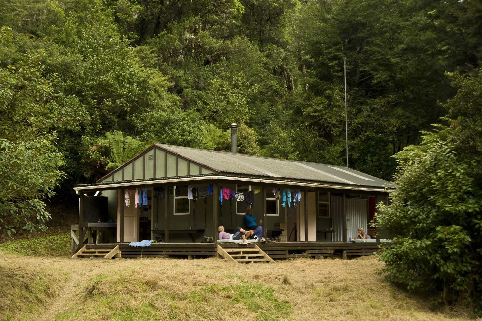
There are several huts to break the journey – Careys, Boundary, and Taipo, all quite small at 4-6 bunks. There are two additional campsites, one at each of the lakes.
Once the Greenstone is reached, Greenstone Hut provides accommodation before you consider your options for carrying on down to Elfin Bay on Lake Wakatipu, or up the Greenstone and over The Divide to the Milford Road.
Wild File
Access Mavora Lakes Road off SH94
Grade Easy
Time 3-4 days. Kiwi Burn access track to South Mavora Lake, 4hr; To Careys Hut, 4hr; To Boundary Hut, 2hr; To Taipo Hut, 3-4hr; To Greenstone Hut, 4hr; To Elfin Bay, 4hr
– PB
November: Whirinaki-Mangamate Circuit, Whirinaki Forest Park
Late Spring is a suitable time to walk this easy 25km circuit, albeit with a ‘wet-boot’ section that gives you practice at navigation and river crossing. This popular little loop has been used for end-of-year school tramps, to get tired teenagers out of the classroom. Hence, it is family friendly with ample room to camp, go eeling or trap possums.
Beginning beneath some of the best podocarp giants in the country, this trail is full of surprises. Following the Whirinaki River, the spectacular bridge spanning Te Whaiti Nui A Toi Canyon is soon reached. Here, languid waters swirl through a narrow defile, while centuries-old kahikatea tower 65m above. Pause here and listen out for kākā.
An hour in, note the smaller tributary flowing in from the left – that’s where you’ll appear on the third day. Another kilometre on, the placid
Whirinaki River changes character, disappearing over an 8m cliff into a frothing cauldron of whitewater. This is a superb spot for lunch.
From here, it’s a heads-down slog alongside the river. The shelter at Verns Camp makes for a suitable stop, then the track ducks through a tunnel before arriving at the spacious 25-bunk Central Whirinaki Hut. At dusk, look out for whio in the water and long-tailed bats flying overhead.
Next day, head further south. At the Taumutu swingbridge, drop your packs and visit a massive cave. After this 60-minute detour, it’s a slow stream-bash up the Kakaiti Stream, then over a small saddle into the Kakanui Stream. A short, sharp climb up to nine-bunk Mangamate Hut ends an adventurous but cruisy day.
The last leg descends into the Mangamate, following this down to the confluence with the Whirinaki River, crisscrossing at will. Water levels are usually low.
Before you can say ‘Whirinaki Te Pua-a-Tane Conservation Park,’ you have come full circle. The temperate lowland rainforest has worked its magic on your mind, and you’ll feel refreshed.
Wild file
Access 20km south of Murapara, turn off SH38 at Te Whaiti, past Minginui to River Road
Grade Easy
Time Three days. To Central Whirinaki Hut, 4-5hr; To Mangamate Hut, 4-5hr; To car park, 4hr
– RS
December: Brass Monkey Bivouac, Lewis Pass Tops, Canterbury/West Coast
According to legend, the expression ‘cold enough to freeze the balls off a brass monkey’ originates from the idea that in exceptionally cold conditions, ship cannonballs would fall off the brass monkey (tray) when the metal contracted. However, like many a good story, it’s unlikely to be true. According to the Oxford English Dictionary, the original expression was ‘tail’ rather than balls. Further, ‘monkey’ was not a term used for the tray and even a very cold snap could not produce the reputed effect. So much for legend.
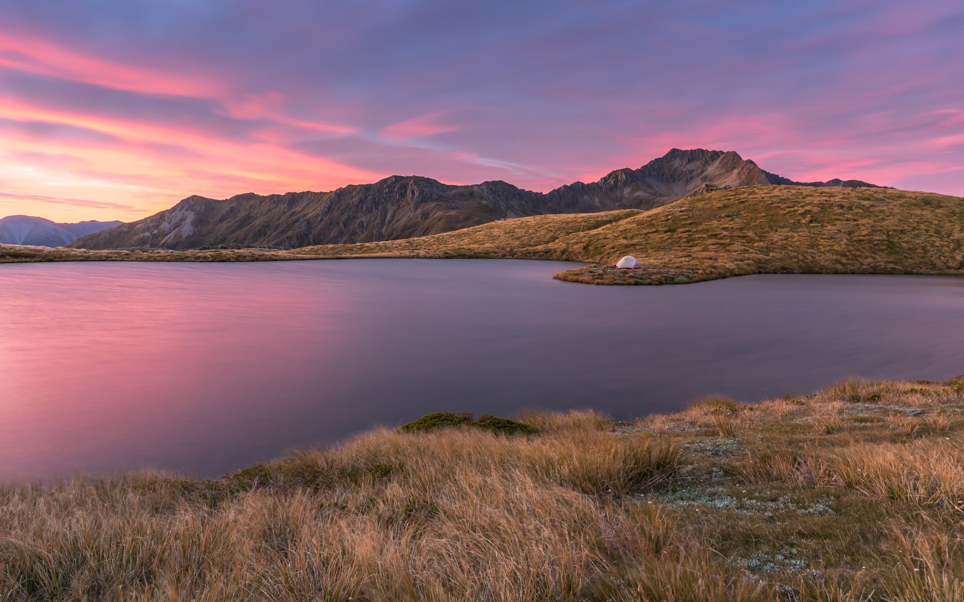
No matter, Brass Monkey Bivouac makes a legendary tramping destination all the same. The small hut probably gets the moniker from its lofty and exposed position on the Lewis Pass Tops. Situated at 1380m means the basic two bunk shelter often gets snow-plastered during winter. I’ve been there once when all the surrounding tarns froze solid and we skated on the ice. Fun as that was, summer is the best season for a visit.
Highlight? Probably the tarn-strewn Lewis Pass tops. It’s easy to use such descriptions flagrantly, but these tops boast so many tarns that it would be difficult to count them all. They range in size from paddling pool to bigger than a swimming pool.
Access is on the Lewis Tops Track, which climbs through a short section of stunted beech forest to the bush edge. Beyond, the undulating tops make for excellent rambling terrain, meandering among the tarns. Mt Technical, with its bold, leading ridges, draws the eye, as do the peaks of the nearby Victoria Range and Nelson Lakes. In December, the alpine flowers are at their best.
Beyond the tarns at the head of Lucretia Stream, the tramping begins to get a bit more demanding. Over the summit of Lucretia, narrow, rocky ridge travel ensues. After traversing a couple more knolls, the route descends to the appealing basin of Brass Monkey Biv. Built in 1971, the hut offers space for two.
It’s worth allowing an extra day to explore the surrounds.
Wild file
Access From Lewis Pass, SH7
Grade Moderate-difficult
Time 6-9hr to Brass Monkey Bivouac
– SB
34 years of inspiring New Zealanders to explore the outdoors. Don’t miss out — subscribe today.

Questions? Contact us


