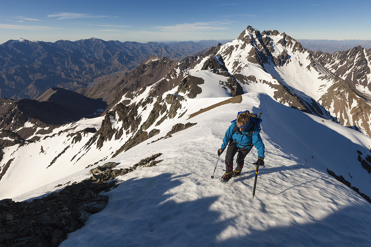
Tapuae O Uenuku Scenic Reserve, Canterbury
Tapuae-o-Uenuku, or Tappy, as it’s more colloquially known, translates to Footsteps of the Rainbow God – a poetic title if ever there was one, but to set foot on it is to discover a mountain quite unlike any other peak in New Zealand.
Standing higher than any other mountain north of Aoraki/Mount Cook National Park and separated from other South Island ranges by a considerable distance, Tappy is an outlier and standing on its summit the view stretches unimpeded for 360-degrees.
In summer, the top is attainable by those with basic ice axe and crampon skills and good route finding ability. Winter requires a greater degree of experience due to avalanche risk.
The journey feels like an expedition with a windy and dusty drive following the Awatere River up the Molesworth Valley.
River crossings are mandatory and you soon lose count as you zigzag dozens of times back and forth across the Hodder River, deep in its incised canyon. The wet feet and the toil upstream are worth it though when you emerge on the pleasant terrace of the Hodder Huts with the summit now in reach.
An early start is advisable to catch any remaining snow while it’s still firm and axe, crampons and helmet should be used.
Time 2-3 days Grade Moderate
Coromandel Forest Park
The inland jewel of the Coromandel, The Pinnacles is a marvellous destination and accessible to all ages, especially with the 80-bunk Pinnacles Hut situated at its base. The walk to the hut is through forest, following an old packhorse route, and is of a mostly easy grade.
From the hut it’s a 45min hike up countless steps along what, at one time, must have been a scary, exposed scramble to the lookout.
The Pinnacles look dramatic and the views of the surrounding steep-sided forested hills and the distant ocean and islands don’t disappoint, either.
Time 6hr Grade Easy
Lake Sumner Forest Park, Canterbury
On a good day, the undulating terrain of the Lewis Tops must be just about a tramper’s paradise. Reached on a short track through beech forest, these are some of the most easily accessible tops in the country, and with dozens of tarns, there’s no shortage of water and swimming holes on a hot summer’s day.
While traversing these undulating tussocklands makes for an easy stroll, for the tramping peak-bagger, there’s the added advantage of a significant challenge ahead: Mt Technical. At 1870m, the peak forms the highest summit in the immediate vicinity, a craggy monolith rising above the tussock apron on its lower flanks.
Several possible routes lead to the summit, all requiring a reasonable head for heights. The route I chose is the west ridge, which begins from a saddle near another peak called The Apprentice.
Travel on the west ridge is easy enough at first, with the occasional crag to sidle on either side, before the route rears up more steeply, and the scrambling proper begins.
The rock offers nothing harder than about grade 8–10, and is generally good by New Zealand standards with just a few loose sections to be careful on. As I was climbing solo, I made particular attention to keep three points of contact, and found the exposure exhilarating.
Where the west ridge joins the north ridge, the gradient eases, but the route finding is not over. There’s more scrambling, and a couple of crevices to negotiate. A battered wooden trig beacon marks the summit, which has extensive views of the encircling mountains.
Happily, for I never like a steep descent, there’s an easier route off the summit ridge, descending a scree gully. From there you can pick a reasonably direct line over rocky ledges on the Lucretia side of the ridge, and make your way back to the Lewis Tops over the saddle near The Apprentice.
While climbing Mt Technical in one day is possible, most parties will opt for a camp en route, or a stay at Brass Monkey Biv (two bunks). Through-trips to Lucretia Stream, or Duchess Stream, both of which lead down into the Nina Valley, offer interesting alternatives back to the Lewis Pass Highway.
Note: if you have any doubts about your ability to tackle the scrambling required for either the north or west ridges, it’s probably best to ascend the scree route normally used on the descent.
Time 8-12hr Grade Difficult

Tararua Forest Park, Wellington
A thrilling peak in the Tararua Range. It’s steep, jagged and requires a good head for heights. At one point a metal ladder is provided and, at another, a rope helps you around Tuiti. Anyone who enjoys climbing fun rocky terrain will enjoy it.
Time 2-3 days Grade Moderate
Reader Sarah Smith explains why Mt Titiroa is a photographer’s dream
Situated in eastern Fiordland, Mt Titiroa protrudes distinctly out of the Hunter Mountains. Although not the highest peak in the range, it glistens in the sun and attracts the attention of many travelling the road south to Te Anau and Lake Manapouri.
Its conspicuous glint often prompts the question, ‘is that snow on the top?’ In winter, the answer would mostly likely be yes. In summer, however, the reflective shine can be attributed to the white sands of the mountain itself.
Noted to be a photographer’s nirvana, I only recently summited this peak, after having it on my radar for a number of years.
On top, the alpine scrub gives way to coarse white sand, dotted with infrequent plant life. Emerging from the desolate sand, monumental granite boulders, in all shapes and forms, scatter across the ridge. Standing, like sentinels, they survey the land.
Below, the cobalt waters of Lake Manapouri and its meandering shore, shrouded in cloud and mist, paint a picture that is distinctly Fiordland; forever changing, damp and mysterious.
To wander around this rare and unique environment is a privilege, the granite boulders and rocky landscape resembling something from another planet. Hours can be spent meandering among the rocks, imagining all sorts of objects and photographing the views.
An awe-inspiring, geological marvel, Mt Titiroa’s desolation and starkness offer a contrast to the dense, wet rainforest typical of Fiordland. Despite this though, it still remains; Fiordland.
Time 18hr (two days) Grade Difficult

Ruahine Forest Park, Manawatu
This is a significant summit on the main spine of the Ruahine Range, and a peak often viewed from the tops above the popular Sunrise Hut. From this eastern angle, it appears formidable, with steep, ragged scree slopes falling away from the summit crags.
However, the peak is easily traversed on its western slopes and makes a good destination for a weekend round-trip, with a night at Sunrise Hut. On a good day, the summit offers fine views eastward over Hawke’s Bay and north and south along the crest of the Ruahine Range.
Time North Block Road to Te Atuaoparapara summit via Waipawa Saddle 3.5-5hr; summit to North Block Road via Sunrise Hut 4-5hr Grade Moderate
Nelson Lakes National Park, Tasman
The highest tramper-accessible peak in the park and a wonderful climb, either as part of the Travers-Sabine circuit or as a return trip from St Arnaud, staying at John Tait Hut for two nights and maybe treating yourself to a boat trip across Lake Rotoiti.
The most accessible route is from the Upper Travers Track, following Summit Creek up to loose scree and rock which is a steep, but manageable scramble to the summit ridge.
Time 3-4 days Grade Hard
Mt Aspiring National Park, Otago
The upper West Matukituki is surrounded by fine mountains and if you climb steeply up the scarp to Cascade Saddle, then a different view unfolds where permanent ice and glaciers roll off a long and undulating ridge above the Dart Glacier.
Head south from here, up the slopes of Mt Tyndall. The climb finishes with an easy scramble and you’re rewarded with wonderful views south and east across the Shotover and West Matukituki valleys.
To the west and north stand Mt Aspiring and the numerous proud peaks towering over the Dart Glacier.
Time Two days Grade Difficult

Editor Alistair Hall recounts his favourite experience on Mt Tongariro
Tongariro is the easiest of the three major Central Plateau volcanoes and can be easily done as a diversion on the Tongariro Alpine Crossing – adding an hour or two to the total walking time.
My all-time favourite experience of the mountain was when I snowshoed my way to the summit one winter and then went off the beaten track on my return to the car park.
I fairly raced along the kilometres of boardwalk in the Mangatepopo Valley, only pausing to catch my breath on the Devil’s Staircase – somewhat tamed after track upgrades – before reaching South Crater and shin-deep snow.
Out came the snow shoes for the plod along the crater and up to Red Crater where poles marked the Mt Tongariro Summit Route.
Other hikers in crampons were already on the route. A girl dropped her walking pole and we watched in silence as it skittered down the steep slope to South Crater. It was a disheartening retrieval for her, but she eventually caught back up with her friends.
The firm snow crunched beneath my snowshoes and though the broad ridge doesn’t provide the thrill of exposure found on knife-edge ridges it’s a magnificent place to be with the flat expanses of Central and North craters on one side, South Crater and the ever-impressive Ngauruhoe on the other. Everything, everywhere blanketed in pristine snow.
From the summit interesting new routes become available. I watched some people descend the northern slope to shortcut their way over Central Crater to rejoin the Tongariro Alpine Crossing on their way to Ketetahi. I was heading back to Mangatepopo car park, so dropped down the eastern side and took Hardmans Ridge (unnamed on topos) down the Mangatepopo Valley. On the way I spied several good campsites.
You’re meant to come off the ridge at Mangatepopo Hut for the final stretch back to the car, but I mistakenly thought the ridge would be quicker. A brutal scrub bash and twice having to leap the Mangatepopo Stream left me utterly exhausted.
But what a day.
Time 6-8hr Grade Moderate
Fourteen-year-old reader Ben Mitchell remembers hot chocolate and bolting down scree slopes on Mt Wakefield
Mt Wakefield is not technically difficult, but it offers superb panoramic views from your first steps including many of Mt Cook National Park’s giants. In fact, if you kept following the ridge past the summit you’d find yourself beyond Ball Pass and at the summit of Aoraki!
Wakefield has really easy access: park the car by the bridge that crosses the Hooker River and start climbing. After an hour you are past the alpine scrub and ready to pop out on the rocky ridge, puffing appreciation of your surroundings.
Further up, huge scree slopes drop from the left of the ridge and provide an exhilarating scree-run to the car on the return.
A few false summits later, leave the ridge and sidle off to a flattish section on the right. Another half-hour upwards and you slip back over the ridge and down into the camping area with a few small tarns (1680m), swimmable in summer and skate-able in winter.
The summit lies an hour onwards, and the view is stunning. You can easily get up and down in a single day in summer, but I prefer the camp-in-snow option. Treat yourself to a hot chocolate at sunset sitting on the high ledges overlooking the Hermitage, Mueller Lake, Mt Sefton and the lower Hooker Glacier.
Time 7-9hr Grade Moderate


34 years of inspiring New Zealanders to explore the outdoors. Don’t miss out — subscribe today.

Questions? Contact us


