- Area
- Arthur's Pass National Park
- Distance
- 27.6km
- Time
- 10-12hr
- Grade
- Moderate
- Accom.
- Upper deception Hut, 6 bunks; Goat Pass Hut, 20 bunks; Mingha Bivouac; Camping beside Lake Mavis
- Access
- Morrison Footbridge (Otira River) or Edwards/Mingha Car park (Bealey River), SH73
- Map
- BV20
- GPX File
- Lake Mavis (gpx, yo 25 KB)
- Your device does not support GPX files. Please try a different device.
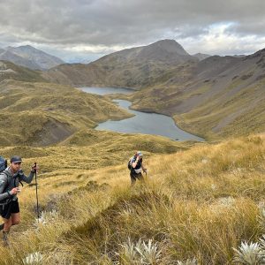
Though positioned at just 1582m, Lake Mavis, nestled in an alpine basin on the side of Mt Oates, is as close as any lake gets to the Main Divide. Those who make the effort to become acquainted with the lake are amply rewarded by spectacular vistas, a pristine environment, and a pervasive sense of peace.
From the Morrison Footbridge on SH73 near Otira, enter the Deception River Valley. A note of warning: this can only be traversed in good weather and low flows.
It begins benignly enough, but after 3-4 hours the boulders gradually increase in size and the walk becomes a scramble. There is no real trail, and the way forward can be hard to detect in places, but as long as you follow the river you cannot go far wrong.
Continue past Upper Deception Hut and on to Goat Pass Hut. From here head 500m up the slope to Lake Mavis. If you have time, camping here is a great experience.
Once down from the lake, continue down the Mingha River. Unlike the Deception, there are numerous boardwalks in the upper reaches and a defined trail most of the way down. It should take around 4-5hr to walk this section to the road end.