Waipakihi Hut via Waipakihi River, Kaimanawa Forest Park
My billy simmered gently on the MSR stove. I could already taste the hard-earned cup of tea. I was chilled and my clothes were wet through, but Waipakihi Hut was warm, a welcome shelter. Outside, snow flakes the size of 20 cent coins fell heavily, building deep drifts.
I had set out with a typical forecast for the Central North Island: showers turning to rain, then the freezing level lowering to 900m, snow and gale force winds. The trip had begun with a 600m climb to Mt Urchin – a good honest grind – and the track was well graded. With the clear weather, the view of the Tongariro National Park mountains from the summit was spectacular.
Beyond Urchin, I began the knee-quivering descent into the Waipakihi and camped beside the river. The trip between the road end and Waipakihi Hut can be completed in a day, but I had decided to take my time.
The Waipakihi is the source of the Tongariro River and below my tent site it meandered through open tussock flats. The peaceful waters here are a contrast to the turbulence and wild white water down-river.
The next morning the weather was dismal; gentle rain with cloud hanging off the tops. I trudged up-valley in the drizzle, with my head down, reminding myself to look around and enjoy the beauty and peace of the place. Even in wet weather the upper Waipakihi River has a certain charm. The banks were surrounded by beech forest broken up by tussock-filled clearings.
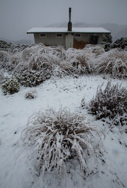
Water slowly soaked through my coat and by late afternoon every layer was wet and I was glad to finally reach the shelter of the oddly-shaped hut. With 12 bunks, Waipakihi is not your usual forest service design. It has a large middle section and two separate bunk rooms on either side, likely added sometime after the completion of the original. It’s cosy enough with an enclosed fire. There’s even running water. Pure luxury.
A map on the wall outlined the complex but interesting land ownership. The mountain range has been carved up and is owned by different groups. DOC administers the lion’s share while the rest is divided between the Helisika Charter Company, NZ Defence Force and a Maori Land Trust. From a tramper’s perspective, I couldn’t help but feel like it was a shame there were so many owners, which makes access to the area more complicated – or impossible in some parts.
After a relaxed night I joined the Umukarikari Track, following red marker poles. The walk was gruelling, the fresh new snow was over my boots and at times I passed through drifts a metre deep. Eventually, late in the afternoon, I reached the road end. The 13km walk had taken seven hours.
Reflecting on the trip, the Waipakihi River is one the most impressive valleys I’ve visited in the North Island. It’s worth taking three days to immerse yourself in the beauty of the place. If you’re looking for an alternative to the busy Tongariro National Park and want to get away from it all, I would highly recommend it.